The Mountains, Peaks, Tops and Hills in The Dark Peak Area of The Peak District, Derbyshire, Greater Manchester, West Yorkshire and South Yorkshire with all the tops you have already bagged in first & then the ones you are yet to climb second.
The Dark Peak Area of The Peak District National Park, Derbyshire, Greater Manchester, West Yorkshire and South Yorkshire is area within the National Park boundary north of the A6 from Hazel Grove to Chapel-en-le-Frith, the A623 to Sparrowpit, the minor road from Sparrowpit along Rushup Edge to Castleton and the A6187 from Castleton to Sheffield.
If you count only the Mountains (Hewitts) there are 2 tops to climb, bag & conquer and the highest point is Kinder Scout at 636m (2,087ft).
To see these Mountains, Peaks, Tops and Hills displayed in different ways - see the options in the left-hand column and towards the bottom of this page.
![]() Your Personal Bagging Record for The Dark Peak Area of The Peak District
Your Personal Bagging Record for The Dark Peak Area of The Peak District
LOG ON and RELOAD this page to show which Mountains, Peaks, Tops and Hills you have already climbed, bagged & conquered [. . . more details]
Scroll down this list of mountains, peaks, tops & hills below and tap/click on each name (in blue) to locate it on the map above.
See this list in: Alphabetical Order‡ | Height Order
To reverse the order select the link again.
Mountain, Peak, Top or Hill already bagged:
Bagged
Top yet to be climbed, bagged & conquered:
Bagged

![]()
1. Bleaklow Head (Bleaklow Hill)
633m (2077ft)
Mountain (Hewitt)
See more details, photos, trip reports and easy-to-follow walks up Bleaklow Head (Bleaklow Hill)
![]()
2. Kinder Scout
636m (2087ft)
Mountain (Hewitt)
See more details, photos, trip reports and easy-to-follow walks up Kinder Scout
![]() Your Personal Bagging Record for The Dark Peak Area of The Peak District
Your Personal Bagging Record for The Dark Peak Area of The Peak District
LOG ON and RELOAD this page to show which Mountains, Peaks, Tops and Hills you have already climbed, bagged & conquered [. . . more details]
View these 2 Mountains, Peaks, Tops and Hills:
- On a Downloadable PDF you can Print or Save to your Phone#
- On an Interactive Google Map (loads faster)
- On an Interactive Google Map with a list of tops below it.
(makes it easier to locate a particular top) - On a Detailed List in:
Alphabetical Order | Height Order - On one page with 'yet-to-be-bagged' listed 1st & then 'already-bagged' tops listed 2nd in:
Alphabetical Order | Height Order - On one page with 'already-bagged' tops listed 1st & then 'yet-to-be-bagged' tops listed 2nd in:
Alphabetical Order | Height Order
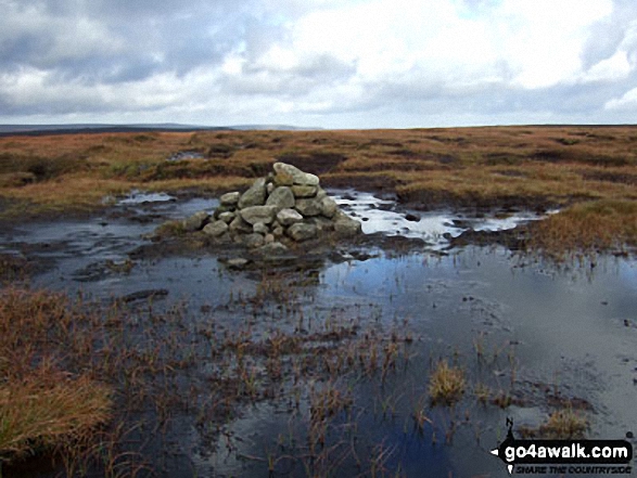 The summit of Kinder Scout in The Dark Peak Area area of The Peak District
Photo: Ben Lockett
# Whether you print a copy or download it to your phone, this Peak Baggers' Map will prove incredibly useful if you want to know what's what when you are up in the mountains and cannot get a phone signal.
Is there a Mountain, Peak, Top or Hill missing from the above google map or list?


