All the Little Hills with a Big, Big View as a detailed list

Walk Little Hills with Big, Big views
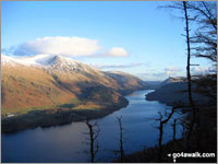
Thirlmere from the summit of Raven Crag
Photo: Ron Anderson

Not everyone wants to walk up huge mountains all of the time.

Indeed, some of Britain's smaller hills offer just as good a view, take less energy to conquer and are not so likely to be shrouded in mist when you get to the summit.

Which, to be honest, would be a bonus!

If you have children and want to take them for a walk, then some of the UK's smaller hills are the perfect way to get your kids smitten by the walking bug and enjoy a healthy day out in the English, Scottish or Welsh countryside.

So here are suggestions for some hills in England, Scotland and Wales with great views that all the family can enjoy.

On our $titleFacebook and $titleTwitter Pages we have been regularly suggesting Little Hills with Big, Big Views for a while now. However, not everyone has access to Facebook or Twitter so here's a list of all of them.

It is not a definitive list - but a growing one. If you have a suggestion for a Little Hill with a Big, Big View that you think all those Mums, Dads, Aunties, Uncles, Boys, Girls, Grandads, Grandmas and the whole the family out there would enjoy walking - then let us know and we will try and add it our our collection.

Oh - and don't forget to upload your photos to our $titleFacebook Wall so we can everyone see them. Enjoy . . .

If you include all the Little Hills with Big, Big Views that are also Wainwrights, Deweys, Wainwright Outlying Fells, Marilyns, Bridgets (Hills) and all the Mountains, Tops, Peaks and Hills with a Trig Point on them there are 102 tops to climb, bag & conquer and the highest point is Tudhope Hill at 599m (1,966ft).


Use these checkboxes to show or hide Mountains, Peaks, Hills and Tops below:-

Wainwright
6/0
Wainwrights

Dewey
30/0
Deweys

Wainwright Outlying Fell
2/0
Wainwright
Outlying Fells

marilyn
27/0
Marilyns

Bridget
48/0
Bridgets

Trig Point
50/0
Trig
Points


To see all Mountains, Peaks, Tops and Hills displayed in different ways - see the options in the left-hand column and towards the bottom of this page.


LOG ON and RELOAD this page to show which Mountains, Peaks, Tops and Hills you have already climbed, bagged & conquered [. . . more]


Page 1 of 4    Go to page: 1 2 3 4


See this list in: Alphabetical Order | Height Order
To reverse the order select the link again.


Mountain, Peak, Top or Hill:

Bagged


1. Tudhope Hill

599m (1,966ft)

  • Bridget
  • OS Trig Point

  • To walk, climb & bag Tudhope Hill use either of these easy to follow walks:

    Google Maps Icon
    See the location of Tudhope Hill and walks up it on a google Map

    Tudhope Hill is on interactive maps:

  • OS Explorer (Orange Covers): 324
  • OS Landranger (Pink Covers): 79

  • A go4awalk.com Peak Bagging Map and Hill Tick List featuring Tudhope Hill will be available soon.


    2. Sugar Loaf (Y Fal)

    596m (1,956ft)

  • Dewey (18th in Wales, 31st in England & Wales)
  • Marilyn (57th in Wales, 776th in GB)
  • OS Trig Point

  • We hope to have walks that climb & bag Sugar Loaf (Y Fal) very soon

    Google Maps Icon
    See the location of Sugar Loaf (Y Fal) and walks up it on a google Map

    Sugar Loaf (Y Fal) is on interactive maps:

  • OS Explorer (Orange Covers): OL13
  • OS Landranger (Pink Covers): 161

  • Sugar Loaf (Y Fal) is on Peak Bagging Map and Hill Tick List:


    3. Kensgriff

    574m (1,883ft)

  • Dewey (36th in England, 80th in England & Wales)

  • To walk, climb & bag Kensgriff use either of these easy to follow walks:

    Google Maps Icon
    See the location of Kensgriff and walks up it on a google Map

    Kensgriff is on interactive maps:

  • OS Explorer (Orange Covers): OL19
  • OS Landranger (Pink Covers): 98

  • Kensgriff is on Peak Bagging Map and Hill Tick List:


    4. Low Kop

    572m (1,877ft)

  • Bridget

  • To walk, climb & bag Low Kop use this easy to follow walk:

    Google Maps Icon
    See the location of Low Kop and walks up it on a google Map

    Low Kop is on interactive maps:

  • OS Explorer (Orange Covers): OL5
  • OS Landranger (Pink Covers): 90

  • Low Kop is on Peak Bagging Map and Hill Tick List:

    *Version including the walk routes marked on it that you need to follow to Walk all 214 Wainwrights in just 59 walks.


    5. Roan Fell

    568m (1,864ft)

  • Marilyn (706th in Scotland, 827th in GB)

  • To walk, climb & bag Roan Fell use either of these easy to follow walks:

    Google Maps Icon
    See the location of Roan Fell and walks up it on a google Map

    Roan Fell is on interactive maps:

  • OS Explorer (Orange Covers): 324
  • OS Landranger (Pink Covers): 79

  • A go4awalk.com Peak Bagging Map and Hill Tick List featuring Roan Fell will be available soon.


    6. Pant y Creigiau

    565m (1,854ft)

  • Dewey (59th in Wales, 106th in England & Wales)
  • OS Trig Point

  • To walk, climb & bag Pant y Creigiau use any of these easy to follow walks:

    Google Maps Icon
    See the location of Pant y Creigiau and walks up it on a google Map

    Pant y Creigiau is on interactive maps:

  • OS Explorer (Orange Covers): OL12
  • OS Landranger (Pink Covers): 160

  • Pant y Creigiau is on Peak Bagging Map and Hill Tick List:


    7. Shining Tor

    559m (1,835ft)

  • Dewey (54th in England, 124th in England & Wales)
  • Marilyn (59th in England, 851st in GB)
  • OS Trig Point
  • Shining Tor is the highest point in the county of Cheshire.


    To walk, climb & bag Shining Tor use any of these easy to follow walks:

    Google Maps Icon
    See the location of Shining Tor and walks up it on a google Map

    Shining Tor is on interactive maps:

  • OS Explorer (Orange Covers): OL24
  • OS Landranger (Pink Covers): 118

  • Shining Tor is on Peak Bagging Map and Hill Tick List:


    8. Pendle Hill (Beacon or Big End)

    557m (1,828ft)

  • Dewey (58th in England, 134th in England & Wales)
  • Marilyn (60th in England, 854th in GB)
  • OS Trig Point

  • To walk, climb & bag Pendle Hill (Beacon or Big End) use any of these easy to follow walks:

    Google Maps Icon
    See the location of Pendle Hill (Beacon or Big End) and walks up it on a google Map

    Pendle Hill (Beacon or Big End) is on interactive maps:

  • OS Explorer (Orange Covers): OL21 and OL41
  • OS Landranger (Pink Covers): 103

  • Pendle Hill (Beacon or Big End) is on Peak Bagging Map and Hill Tick List:


    9. Aye Gill Pike

    556m (1,824ft)

  • Dewey (60th in England, 139th in England & Wales)
  • Marilyn (61st in England, 856th in GB)
  • OS Trig Point

  • To walk, climb & bag Aye Gill Pike use either of these easy to follow walks:

    Google Maps Icon
    See the location of Aye Gill Pike and walks up it on a google Map

    Aye Gill Pike is on interactive maps:

  • OS Explorer (Orange Covers): OL2
  • OS Landranger (Pink Covers): 98

  • Aye Gill Pike is on Peak Bagging Map and Hill Tick List:


    10. Moel Famau

    555m (1,821ft)

  • Dewey (79th in Wales, 141st in England & Wales)
  • Marilyn (66th in Wales, 860th in GB)
  • OS Trig Point
  • Moel Famau is the highest point in the county of Flintshire.


    To walk, climb & bag Moel Famau use this easy to follow walk:

    Google Maps Icon
    See the location of Moel Famau and walks up it on a google Map

    Moel Famau is on interactive maps:

  • OS Explorer (Orange Covers): 265
  • OS Landranger (Pink Covers): 116

  • A go4awalk.com Peak Bagging Map and Hill Tick List featuring Moel Famau will be available soon.


    11. Crug Mawr

    550m (1,805ft)

  • Bridget
  • OS Trig Point

  • To walk, climb & bag Crug Mawr use this easy to follow walk:

    Google Maps Icon
    See the location of Crug Mawr and walks up it on a google Map

    Crug Mawr is on interactive maps:

  • OS Explorer (Orange Covers): OL13
  • OS Landranger (Pink Covers): 161

  • Crug Mawr is on Peak Bagging Map and Hill Tick List:


    12. Black Hag (Hethpool)

    549m (1,801ft)

  • Dewey (73rd in England, 169th in England & Wales)

  • To walk, climb & bag Black Hag (Hethpool) use this easy to follow walk:

    Google Maps Icon
    See the location of Black Hag (Hethpool) and walks up it on a google Map

    Black Hag (Hethpool) is on interactive maps:

  • OS Explorer (Orange Covers): OL16
  • OS Landranger (Pink Covers): 74

  • A go4awalk.com Peak Bagging Map and Hill Tick List featuring Black Hag (Hethpool) will be available soon.


    13. Lord's Seat (Rushup Edge)

    546m (1,791ft)

  • Dewey (80th in England, 184th in England & Wales)

  • To walk, climb & bag Lord's Seat (Rushup Edge) use any of these easy to follow walks:

    Google Maps Icon
    See the location of Lord's Seat (Rushup Edge) and walks up it on a google Map

    Lord's Seat (Rushup Edge) is on interactive maps:

  • OS Explorer (Orange Covers): OL1
  • OS Landranger (Pink Covers): 110

  • Lord's Seat (Rushup Edge) is on Peak Bagging Map and Hill Tick List:


    14. Mill Hill (Ashop Head)

    544m (1,785ft)

  • Dewey (86th in England, 197th in England & Wales)

  • To walk, climb & bag Mill Hill (Ashop Head) use any of these easy to follow walks:

    Google Maps Icon
    See the location of Mill Hill (Ashop Head) and walks up it on a google Map

    Mill Hill (Ashop Head) is on interactive maps:

  • OS Explorer (Orange Covers): OL1
  • OS Landranger (Pink Covers): 109

  • Mill Hill (Ashop Head) is on Peak Bagging Map and Hill Tick List:


    15. Outer Edge

    541m (1,775ft)

  • Bridget
  • OS Trig Point

  • To walk, climb & bag Outer Edge use any of these easy to follow walks:

    Google Maps Icon
    See the location of Outer Edge and walks up it on a google Map

    Outer Edge is on interactive maps:

  • OS Explorer (Orange Covers): OL1
  • OS Landranger (Pink Covers): 110

  • Outer Edge is on Peak Bagging Map and Hill Tick List:


    16. Brown Clee Hill (Abdon Burf)

    540m (1,772ft)

  • Dewey (93rd in England, 212th in England & Wales)
  • Marilyn (66th in England, 895th in GB)
  • OS Trig Point
  • Brown Clee Hill (Abdon Burf) is the highest point in the county of Shropshire


    To walk, climb & bag Brown Clee Hill (Abdon Burf) use this easy to follow walk:

    Google Maps Icon
    See the location of Brown Clee Hill (Abdon Burf) and walks up it on a google Map

    Brown Clee Hill (Abdon Burf) is on interactive maps:

  • OS Explorer (Orange Covers): 217
  • OS Landranger (Pink Covers): 137 and 138

  • Brown Clee Hill (Abdon Burf) is on Peak Bagging Map and Hill Tick List:


    17. Cuns Fell

    539m (1,769ft)

  • Dewey (94th in England, 215th in England & Wales)

  • To walk, climb & bag Cuns Fell use this easy to follow walk:

    Google Maps Icon
    See the location of Cuns Fell and walks up it on a google Map

    Cuns Fell is on interactive maps:

  • OS Explorer (Orange Covers): OL31
  • OS Landranger (Pink Covers): 91

  • Cuns Fell is on Peak Bagging Map and Hill Tick List:


    18. Great Mis Tor

    539m (1,768ft)

  • Dewey (95th in England, 216th in England & Wales)

  • To walk, climb & bag Great Mis Tor use any of these easy to follow walks:

    Google Maps Icon
    See the location of Great Mis Tor and walks up it on a google Map

    Great Mis Tor is on interactive maps:

  • OS Explorer (Orange Covers): OL28
  • OS Landranger (Pink Covers): 191

  • Great Mis Tor is on Peak Bagging Map and Hill Tick List:


    19. Back Tor (Derwent Edge)

    538m (1,766ft)

  • Dewey (96th in England, 219th in England & Wales)
  • OS Trig Point

  • To walk, climb & bag Back Tor (Derwent Edge) use any of these easy to follow walks:

    Google Maps Icon
    See the location of Back Tor (Derwent Edge) and walks up it on a google Map

    Back Tor (Derwent Edge) is on interactive maps:

  • OS Explorer (Orange Covers): OL1
  • OS Landranger (Pink Covers): 110

  • Back Tor (Derwent Edge) is on Peak Bagging Map and Hill Tick List:


    20. Ellson Fell

    537m (1,762ft)

  • Marilyn (758th in Scotland, 900th in GB)

  • To walk, climb & bag Ellson Fell use either of these easy to follow walks:

    Google Maps Icon
    See the location of Ellson Fell and walks up it on a google Map

    Ellson Fell is on interactive maps:

  • OS Explorer (Orange Covers): 323
  • OS Landranger (Pink Covers): 79

  • A go4awalk.com Peak Bagging Map and Hill Tick List featuring Ellson Fell will be available soon.


    21. Castle Knott

    536m (1,759ft)

  • Dewey (102nd in England, 237th in England & Wales)

  • To walk, climb & bag Castle Knott use this easy to follow walk:

    Google Maps Icon
    See the location of Castle Knott and walks up it on a google Map

    Castle Knott is on interactive maps:

  • OS Explorer (Orange Covers): OL2
  • OS Landranger (Pink Covers): 97

  • Castle Knott is on Peak Bagging Map and Hill Tick List:


    22. Titterstone Clee Hill

    533m (1,749ft)

  • Dewey (106th in England, 247th in England & Wales)
  • Marilyn (69th in England, 912th in GB)
  • OS Trig Point

  • To walk, climb & bag Titterstone Clee Hill use this easy to follow walk:

    Google Maps Icon
    See the location of Titterstone Clee Hill and walks up it on a google Map

    Titterstone Clee Hill is on interactive maps:

  • OS Explorer (Orange Covers): 217
  • OS Landranger (Pink Covers): 137 and 138

  • Titterstone Clee Hill is on Peak Bagging Map and Hill Tick List:


    23. Steeperton Tor

    532m (1,746ft)

  • Dewey (110th in England, 258th in England & Wales)

  • To walk, climb & bag Steeperton Tor use either of these easy to follow walks:

    Google Maps Icon
    See the location of Steeperton Tor and walks up it on a google Map

    Steeperton Tor is on interactive maps:

  • OS Explorer (Orange Covers): OL28
  • OS Landranger (Pink Covers): 191

  • Steeperton Tor is on Peak Bagging Map and Hill Tick List:


    24. High Snockrigg

    526m (1,726ft)

  • Dewey (121st in England, 282nd in England & Wales)

  • To walk, climb & bag High Snockrigg use either of these easy to follow walks:

    Google Maps Icon
    See the location of High Snockrigg and walks up it on a google Map

    High Snockrigg is on interactive maps:

  • OS Explorer (Orange Covers): OL4
  • OS Landranger (Pink Covers): 89 and 90

  • High Snockrigg is on Peak Bagging Map and Hill Tick List:

    *Version including the walk routes marked on it that you need to follow to Walk all 214 Wainwrights in just 59 walks.


    25. Crookstone Knoll (Kinder Scout)

    521m (1,710ft)

  • Bridget

  • To walk, climb & bag Crookstone Knoll (Kinder Scout) use this easy to follow walk:

    Google Maps Icon
    See the location of Crookstone Knoll (Kinder Scout) and walks up it on a google Map

    Crookstone Knoll (Kinder Scout) is on interactive maps:

  • OS Explorer (Orange Covers): OL1
  • OS Landranger (Pink Covers): 110

  • Crookstone Knoll (Kinder Scout) is on Peak Bagging Map and Hill Tick List:


    26. Brownber Hill

    519m (1,703ft)

  • Dewey (141st in England, 322nd in England & Wales)

  • To walk, climb & bag Brownber Hill use either of these easy to follow walks:

    Google Maps Icon
    See the location of Brownber Hill and walks up it on a google Map

    Brownber Hill is on interactive maps:

  • OS Explorer (Orange Covers): OL19
  • OS Landranger (Pink Covers): 91

  • Brownber Hill is on Peak Bagging Map and Hill Tick List:


    27. Dunkery Beacon

    519m (1,703ft)

  • Dewey (140th in England, 319th in England & Wales)
  • Marilyn (72nd in England, 940th in GB)
  • OS Trig Point
  • Dunkery Beacon is the highest point in the county of Somerset.


    To walk, climb & bag Dunkery Beacon use either of these easy to follow walks:

    Google Maps Icon
    See the location of Dunkery Beacon and walks up it on a google Map

    Dunkery Beacon is on interactive maps:

  • OS Explorer (Orange Covers): OL9
  • OS Landranger (Pink Covers): 181

  • A go4awalk.com Peak Bagging Map and Hill Tick List featuring Dunkery Beacon will be available soon.


    28. Broadhope Hill

    517m (1,696ft)

  • Dewey (146th in England, 335th in England & Wales)

  • To walk, climb & bag Broadhope Hill use this easy to follow walk:

    Google Maps Icon
    See the location of Broadhope Hill and walks up it on a google Map

    Broadhope Hill is on interactive maps:

  • OS Explorer (Orange Covers): OL16
  • OS Landranger (Pink Covers): 74 and 75

  • A go4awalk.com Peak Bagging Map and Hill Tick List featuring Broadhope Hill will be available soon.


    29. Mam Tor

    517m (1,696ft)

  • Dewey (145th in England, 334th in England & Wales)
  • OS Trig Point

  • To walk, climb & bag Mam Tor use any of these easy to follow walks:

    Google Maps Icon
    See the location of Mam Tor and walks up it on a google Map

    Mam Tor is on interactive maps:

  • OS Explorer (Orange Covers): OL1
  • OS Landranger (Pink Covers): 110

  • Mam Tor is on Peak Bagging Map and Hill Tick List:


    30. North Hessary Tor

    517m (1,696ft)

  • Dewey (147th in England, 336th in England & Wales)
  • OS Trig Point

  • To walk, climb & bag North Hessary Tor use either of these easy to follow walks:

    Google Maps Icon
    See the location of North Hessary Tor and walks up it on a google Map

    North Hessary Tor is on interactive maps:

  • OS Explorer (Orange Covers): OL28
  • OS Landranger (Pink Covers): 191

  • North Hessary Tor is on Peak Bagging Map and Hill Tick List:


    Page 1 of 4    Go to page: 1 2 3 4


    View all 0 Mountains, Peaks, Tops and Hills in Little Hills with a Big, Big ViewDartmoor:


    Is there a Mountain, Peak, Top or Hill missing from the above google map or list?

    Let us know an we will add it to our database.


    Follow go4awalk.com on Twitter Follow go4awalk.com on Facebook


    Home


    Find new Friends to go walking with

    Walk all 214 Wainwrights in just 59 Walks. Download GPS Waypoints - Great Walks you must not miss!

    Walk The Yorkshire Three Peaks Challenge Walk - All the Latest Route Information, GPS Waypoints and Split Times to keep you on Schedule

    Walk The British Three Peaks Challenge Walk - All the Latest Route Information and GPS Waypoints

    See our pick of The Best Walks in The Lake District - Great Walks you must not miss!

    Walk our pick of the Best Lake District Ridge Walks - Great Walks you must not miss!

    Walk our pick of the Best Lake District Walks to do in the rain - Great Walks you must not miss!

    Walk our pick of The Best Walks in Snowdonia - Great Walks you must not miss!

    Walk our pick of The Best Ridge Walks in Wales - Walks you must not miss!

    Walk our pick of The Best Walks in The Brecon Beacons - Great Walks you must not miss!

    Walk our pick of The Best Walks in The Yorkshire Dales - Walks you must not miss!

    Walk our pick of The Best Walks in The Peak District - Walks you must not miss!

    Walk our pick of The Best Walks in The Forest of Bowland - Walks you must not miss!

    Walk our pick of The Best Walks in Shropshire - Walks you must not miss!

    Walk our pick of The Best Walks in Cheshire - Walks you must not miss!

    Walk our pick of The Best Walks in Lancashire - Walks you must not miss!

    Not sure where to walk next? Try Peak Bagging - Great Walks you must not miss!

    Not sure where to walk next? Walk part of a National Trail - Great Walks you must not miss!

    Walks with Downloadable and Uploadable GPS Waypoint Data

    Walking Kit and Gear Tested by Walkers

    Full Site Search