The Mountains, Peaks, Tops and Hills in Bannau Brycheiniog (The Brecon Beacons National Park), Carmarthenshire, Merthyr Tydfil, Monmouthshire, Powys, Rhondda Cynon Taff with all the tops you have already bagged in first & then the ones you are yet to climb second.
Bannau Brycheiniog (The Brecon Beacons National Park), Carmarthenshire, Merthyr Tydfil, Monmouthshire, Powys, Rhondda Cynon Taff is located in South Wales covering part of the counties of Blaenau Gwent, Caerphilly, Carmarthenshire, Merthyr Tydfil, Monmouthshire, Powys, Rhondda Cynon Taf and Torfaen.
If you count only the Deweys there are 21 tops to climb, bag & conquer and the highest point is Mynydd Troed at 609m (1,999ft).
To see these Mountains, Peaks, Tops and Hills displayed in different ways - see the options in the left-hand column and towards the bottom of this page.
![]() Your Personal Bagging Record for Bannau Brycheiniog (The Brecon Beacons National Park)
Your Personal Bagging Record for Bannau Brycheiniog (The Brecon Beacons National Park)
When logged on, you can mark each Mountain, Peak, Top or Hill as 'bagged' by either:
- if you opt to display the tops in this area using a google map, click or tap on its symbol on the map below. This will open a text window. Click or tap on the 'Record [mountain name] as Bagged, Climbed & Conquered' link towards the bottom of the text window, or
- if you opt to display the tops in this area as a list, click or tap on the red 'not yet' symbol to the right of the name of each 'top'
Either method will open a new page where you can complete all your details such as:
- when you bagged the Mountain, Peak, Top or Hill;
- which route you took
- who you went with
- what the weather was like
- any other comment that will remind you of the day
Once you have completed your details and click or tap the submit button, you will automatically return to this page and the top you bagged will show with a green tick.
NB. None of the above fields are 'mandatory' - you can leave them blank if you wish.
NNB. You also have the option whether to display your peak bagging exploits to other users of this site or keep them private so only you can see them when you are logged on.
Furthermore, since you can also access your Personal Mountain & Hill Bagging Record via go4awalk Mobile you can quickly & easily record, edit and view your achievements - whether you are at home/work on your desktop computer or in the pub/at the top of a mountain with your Mobile Phone. (You can even download your Personal Mountain & Hill Bagging Record as a .csv file for importing into and saving with spreadsheet software like Excel or NeoOffice!)
This facility costs one credit to initially access your personal bagging record. Once accessed, all other interactions, such as recording other Mountains, Peaks, Tops and Hills as 'bagged' or altering an existing bagging record, are free.
Click REGISTER to register and purchase credits.
LOG ON and RELOAD this page to show which Mountains, Peaks, Tops and Hills you have already climbed, bagged & conquered. [ . . . remove this text]
Scroll down this list of mountains, peaks, tops & hills below and tap/click on each name (in blue) to locate it on the map above.
See this list in: Alphabetical Order | Height Order‡
To reverse the order select the link again.
Mountain, Peak, Top or Hill already bagged:
Bagged
Top yet to be climbed, bagged & conquered:
Bagged

![]()
1. Mynydd Troed
609m (1999ft)
Dewey
See more details, photos, trip reports and easy-to-follow walks up Mynydd Troed
![]()
2. Yr Allt (Forest Fawr)
604m (1982ft)
Dewey
See more details, photos, trip reports and easy-to-follow walks up Yr Allt (Forest Fawr)
![]()
3. Foel Fraith
602m (1975ft)
Dewey
See more details, photos, trip reports and easy-to-follow walks up Foel Fraith
![]()
4. Sugar Loaf (Y Fal)
596m (1956ft)
Dewey
See more details, photos, trip reports and easy-to-follow walks up Sugar Loaf (Y Fal)
![]()
5. Moel Feity
591m (1939ft)
Dewey
See more details, photos, trip reports and easy-to-follow walks up Moel Feity
![]()
6. Pant y Creigiau
565m (1854ft)
Dewey
See more details, photos, trip reports and easy-to-follow walks up Pant y Creigiau
![]()
7. Bryn (Waun Rydd)
562m (1844ft)
Dewey
See more details, photos, trip reports and easy-to-follow walks up Bryn (Waun Rydd)
![]()
8. Waun Leuci (Cefn Cul)
562m (1844ft)
Dewey
See more details, photos, trip reports and easy-to-follow walks up Waun Leuci (Cefn Cul)
![]()
9. Blorenge (Blorens)
561m (1841ft)
Dewey
See more details, photos, trip reports and easy-to-follow walks up Blorenge (Blorens)
![]()
10. Carreg Goch
558m (1831ft)
Dewey
See more details, photos, trip reports and easy-to-follow walks up Carreg Goch
![]()
11. Mynydd Llangynidr
557m (1828ft)
Dewey
See more details, photos, trip reports and easy-to-follow walks up Mynydd Llangynidr
![]()
12. Cefn y Cylchau
556m (1825ft)
Dewey
See more details, photos, trip reports and easy-to-follow walks up Cefn y Cylchau
![]()
13. Tor y Foel
551m (1808ft)
Dewey
See more details, photos, trip reports and easy-to-follow walks up Tor y Foel
![]()
14. Disgwylfa (Waun Fignen Felen)
544m (1785ft)
Dewey
See more details, photos, trip reports and easy-to-follow walks up Disgwylfa (Waun Fignen Felen)
![]()
15. Bryniau Gleision (Talybont Reservoir)
538m (1766ft)
Dewey
![]()
16. Carreg Cadno
538m (1765ft)
Dewey
See more details, photos, trip reports and easy-to-follow walks up Carreg Cadno
![]()
17. Carn Pen-rhiw-ddu
534m (1752ft)
Dewey
See more details, photos, trip reports and easy-to-follow walks up Carn Pen-rhiw-ddu
![]()
18. Hatterrall Hill
531m (1742ft)
Dewey
See more details, photos, trip reports and easy-to-follow walks up Hatterrall Hill
![]()
19. Twr Pen-cyrn (Mynydd Llangattwg)
529m (1736ft)
Dewey
See more details, photos, trip reports and easy-to-follow walks up Twr Pen-cyrn (Mynydd Llangattwg)
![]()
20. Mynydd Llangorse
515m (1690ft)
Dewey
See more details, photos, trip reports and easy-to-follow walks up Mynydd Llangorse
![]()
21. Allt Forgan
513m (1684ft)
Dewey
See more details, photos, trip reports and easy-to-follow walks up Allt Forgan
![]() Your Personal Bagging Record for Bannau Brycheiniog (The Brecon Beacons National Park)
Your Personal Bagging Record for Bannau Brycheiniog (The Brecon Beacons National Park)
When logged on, you can mark each Mountain, Peak, Top or Hill as 'bagged' by either:
- if you opt to display the tops in this area using a google map, click or tap on its symbol on the map below. This will open a text window. Click or tap on the 'Record [mountain name] as Bagged, Climbed & Conquered' link towards the bottom of the text window, or
- if you opt to display the tops in this area as a list, click or tap on the red 'not yet' symbol to the right of the name of each 'top'
Either method will open a new page where you can complete all your details such as:
- when you bagged the Mountain, Peak, Top or Hill;
- which route you took
- who you went with
- what the weather was like
- any other comment that will remind you of the day
Once you have completed your details and click or tap the submit button, you will automatically return to this page and the top you bagged will show with a green tick.
NB. None of the above fields are 'mandatory' - you can leave them blank if you wish.
NNB. You also have the option whether to display your peak bagging exploits to other users of this site or keep them private so only you can see them when you are logged on.
Furthermore, since you can also access your Personal Mountain & Hill Bagging Record via go4awalk Mobile you can quickly & easily record, edit and view your achievements - whether you are at home/work on your desktop computer or in the pub/at the top of a mountain with your Mobile Phone. (You can even download your Personal Mountain & Hill Bagging Record as a .csv file for importing into and saving with spreadsheet software like Excel or NeoOffice!)
This facility costs one credit to initially access your personal bagging record. Once accessed, all other interactions, such as recording other Mountains, Peaks, Tops and Hills as 'bagged' or altering an existing bagging record, are free.
Click REGISTER to register and purchase credits.
LOG ON and RELOAD this page to show which Mountains, Peaks, Tops and Hills you have already climbed, bagged & conquered. [ . . . remove this text]
View these 21 Mountains, Peaks, Tops and Hills:
- On Two Downloadable PDFs you can print or save to your phone covering:
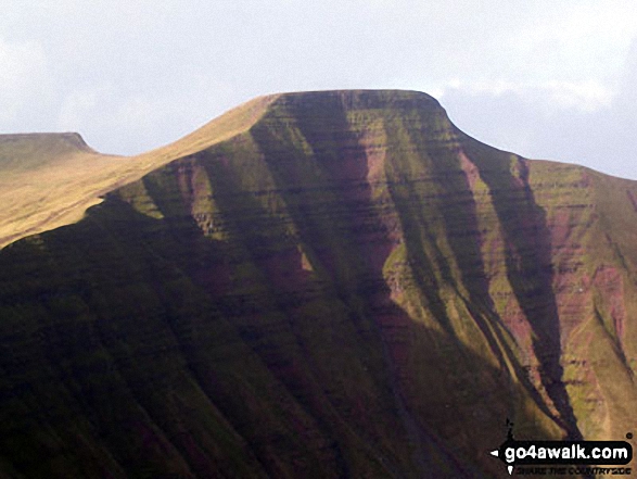 Pen y Fan in Bannau Brycheiniog (The Brecon Beacons)
Photo: Paul Holroyd
- On an Interactive Google Map (loads faster)
- On an Interactive Google Map with a list of tops below it.
(makes it easier to locate a particular top) - On a Detailed List in:
Alphabetical Order | Height Order - On one page with 'yet-to-be-bagged' listed 1st & then 'already-bagged' tops listed 2nd in:
Alphabetical Order | Height Order - On one page with 'already-bagged' tops listed 1st & then 'yet-to-be-bagged' tops listed 2nd in:
Alphabetical Order | Height Order
Is there a Mountain, Peak, Top or Hill missing from the above google map or list?


