Dewey & Marilyn Icon

Tor y Foel
551m (1808ft)


The Black Mountains, The Brecon Beacons, Powys, Wales

The summit of Tor y Foel is marked by a cairn..


Record Tor y Foel as Bagged, Climbed & Conquered

Welsh Dewey Icon

Welsh Dewey
88th in Wales,
156th in England & Wales

Welsh Marilyn Icon

Welsh Marilyn
68th highest in Wales,
871st highest in Great Britain

Walk Tor y Foel walking UK Mountains in The Black Mountains The Brecon Beacons National Park Powys, Wales

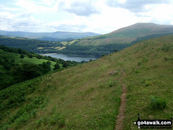
Tor y Foel beyond Talybont Reservoir from the lower slopes of Twyn Du (Waun Rydd)

Photo: Jan Bowkler


Not familiar with this top?

How is Tor y Foel classified?

See the location of Tor y Foel on an interactive Google Map

See the location of Tor y Foel on an interactive Google Bagging Map

See downloadable Bagging Map in PDF format that includes Tor y Foel

Read walk reports from hikers who have already bagged Tor y Foel

View more photographs & pictures of views from, on or of Tor y Foel


We will be adding easy-to-follow route maps up Tor y Foel very soon.

See Tor y Foel and the surrounding tops on our free-to-access 'Google Style' Peak Bagging Maps:

Find Google Maps Peak Bagging Map Icon

The Whole of Bannau Brycheiniog (The Brecon Beacons National Park)

Find Google Maps Peak Bagging Map Icon

The Black Mountains Area of Bannau Brycheiniog (The Brecon Beacons National Park)


See Tor y Foel and the surrounding tops on our downloadable Peak Bagging Map in PDF format:

Find PDF Peak Bagging Map Icon

The Black Mountains Area area of Bannau Brycheiniog (The Brecon Beacons National Park)

NB: Whether you print off a copy or download it to your phone, this PDF Peak Baggers' Map might prove incredibly useful when your are up there on the tops and you cannot get a phone signal.


You can find Tor y Foel & all the walks that climb it on these unique free-to-access Interactive Walk Planning Maps:

The Brecon Beacons National Park


1:25,000 scale OS Explorer Map (orange/yellow covers):

OS Explorer OL13 Brecon Beacons National Park - Eastern area


1:50,000 scale OS Landranger Map (pink/magenta covers):

OS Landranger 161 Abergavenny & The Black Mountains


Other walkers who hiked, climbed, bagged and summited Tor y Foel Fellow go4awalkers who have already walked, climbed, summited & bagged Tor y Foel

Sion Britton walked up on January 5th, 2022 [from/via/route] O Maes Parcio Blaen y Glyn Uchaf. [with] Solo [weather] Oer/ Eira

Richard Penney climbed it on January 16th, 2013 [from/via/route] From dam at Talybont. Forestry has closed several paths so diverted & followed Usk Valley walk but then went off-piste directly up NW face in snow. Steep, rough terrain, no paths & quite hard work. [weather] Dry, cold, clear, snow. - Brilliant.

Pamela French, Jospeh Seddon, Paul Roddam and Michael Rygol have all walked, climbed & bagged Tor y Foel.

To add (or remove) your name and experiences on this page - Log On and edit your Personal Mountain Bagging Record


More Photographs & Pictures of views from, on or of Tor y Foel

A snow capped Tor Y Foel from Talybont Reservoir Dam

A snow capped Tor Y Foel from Talybont Reservoir Dam

Photo: Richard Penney (1)


Send us your photographs and pictures on, of, or from Tor y Foel

If you would like to add your walk photographs and pictures featuring views from, on or of Tor y Foel to this page, please send them as email attachments (configured for any computer) along with your name to:


and we shall do our best to publish them.

(Guide Resolution = 300dpi. At least = 660pixels (wide) x 440 pixels (high).)

Send us your photographs and pictures on, of, or from Tor y Foel via Facebook

You can also submit photos via our Facebook Page.

NB. Please indicate where each photo was taken.


Not familiar with this top?

How is Tor y Foel classified?

See the location of Tor y Foel on an interactive Google Map

See the location of Tor y Foel on an interactive Google Bagging Map

See downloadable Bagging Map in PDF format that includes Tor y Foel

Read walk reports from hikers who have already bagged Tor y Foel

View more photographs & pictures of views from, on or of Tor y Foel


Follow go4awalk.com on Twitter Follow go4awalk.com on Facebook


Home


Find new Friends to go walking with

Walk all 214 Wainwrights in just 59 Walks. Download GPS Waypoints - Great Walks you must not miss!

Walk The Yorkshire Three Peaks Challenge Walk - All the Latest Route Information, GPS Waypoints and Split Times to keep you on Schedule

Walk The British Three Peaks Challenge Walk - All the Latest Route Information and GPS Waypoints

See our pick of The Best Walks in The Lake District - Great Walks you must not miss!

Walk our pick of the Best Lake District Ridge Walks - Great Walks you must not miss!

Walk our pick of the Best Lake District Walks to do in the rain - Great Walks you must not miss!

Walk our pick of The Best Walks in Snowdonia - Great Walks you must not miss!

Walk our pick of The Best Ridge Walks in Wales - Walks you must not miss!

Walk our pick of The Best Walks in The Brecon Beacons - Great Walks you must not miss!

Walk our pick of The Best Walks in The Yorkshire Dales - Walks you must not miss!

Walk our pick of The Best Walks in The Peak District - Walks you must not miss!

Walk our pick of The Best Walks in The Forest of Bowland - Walks you must not miss!

Walk our pick of The Best Walks in Shropshire - Walks you must not miss!

Walk our pick of The Best Walks in Cheshire - Walks you must not miss!

Walk our pick of The Best Walks in Lancashire - Walks you must not miss!

Not sure where to walk next? Try Peak Bagging - Great Walks you must not miss!

Not sure where to walk next? Walk part of a National Trail - Great Walks you must not miss!

Walks with Downloadable and Uploadable GPS Waypoint Data

Walking Kit and Gear Tested by Walkers

Full Site Search