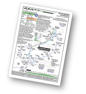
12 easy-to-follow circular walk route maps of all grades in The Far Eastern Marches area of The Lake District
Twelve easy-to-follow, hand-crafted walks including routes from Demings Moss, Shap, Huck's Bridge & Wythmoor Farm that climb Great Yarlside (the highest point), Wasdale Pike, Ancrow Brow, High Wether Howe, Seat Robert, Capplebarrow & Grayrigg Forest amongst others. More details about each walk can be found below the map.
The Far Eastern Marches area of The Lake District National Park is the area enclosed by:
- An imaginary line from Ambleside through Troutbeck, Kentmere and Sadgill to the Eastern tip of Haweswater Reservoir and then Pooley Bridge to the West
- The A592 to Penrith to the North
- The M6 South & then the A684 to Kendal to the East
- The A591 from Kendal to Ambleside to the South
Tap/mouse over a coloured circle (1-3 easy walks, 4-6 moderate walks, 7-9 hard walks) and click to select.
You can use these checkboxes to show only the grades of walk you are interested in:-
Scroll down the list of walks below & click on each walk title (in blue) to locate it on the map above.
See this list of walks, routes & maps in:
Grade Order | Length Order | Time Order | Walk Number or Start Location Order
NB. To reverse (toggle) this order, click Grade Order again
   |
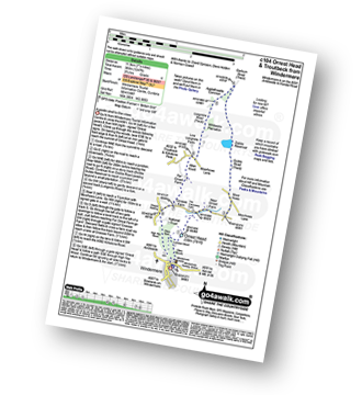
Vital Statistics:
| Length: | 11 miles (17.5 km) |
| Ascent: | 2,655ft (809m) |
| Time: | 6.75hrs |
| Grade: |  |
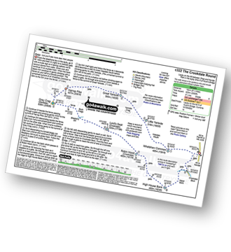
Route Summary:
Swindale - Swindale Foot Farm - Swindale Beck - Starling Gill - Stubby Hest - Bracken Howe - Thiefstead - Langhowe Pike - High Katelade - Rowantree Crag - Blea Moss - Stone Howe - Glede Howe - Willy Winder Hill - Haskew Beck - Fewling Stones - Swindale Common - Mosedale Beck (Swindale) - Nabs Moor - Nabs Crag - Howes (Mosedale) - Captain Whelter Bog - Branstree (North East Top) - Branstree (Artlecrag Pike) - Swirle Crag - Selside Pike - High Blake Dodd - Selside End - High Birkin Knott - Low Birkin Knott - Old Corpse Road - Thorny Knott - Swindale Head Farm - Truss Gap - Swindale Foot Farm - Swindale
|
Vital Statistics:
| Length: | 9.5 miles (15 km) |
| Ascent: | 2,050ft (625m) |
| Time: | 5½ hrs |
| Grade: |  |
Route Summary:
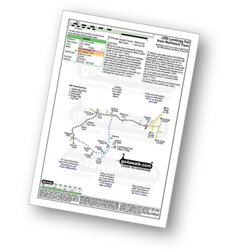
Demings Moss - Shap - Whatshaw Common - Little Yarlside - Great Yarlside - Harrop Pike - Grey Crag (Sleddale) - Lord's Seat (Crookdale) - Robin Hood (Crookdale) - High House Bank - Demings Moss - Shap.
|
Vital Statistics:
| Length: | 8.5 miles (13.5 km) |
| Ascent: | 1,952ft (595m) |
| Time: | 5 hrs |
| Grade: | |
Route Summary:
Swindale - Swindale Foot Farm - Swindale Beck - Starling Gill - Stubby Hest - Bracken Howe - Thiefstead - Langhowe Pike - High Katelade - Rowantree Crag - Blea Moss - Stone Howe - Glede Howe - Willy Winder Hill - Haskew Beck - Fewling Stones - Swindale Common - Mosedale Beck (Swindale) - Nabs Moor - Nabs Crag - Howes (Mosedale) - Nabs Crag - Nabs Moor - Dodd Bottom - Hobgrumble Gill - Swindale Head Farm - Truss Gap - Swindale Foot Farm - Swindale
|
Vital Statistics:
| Length: | 11.25 miles (18 km) |
| Ascent: | 1,614ft (492m) |
| Time: | 5.75hrs |
| Grade: | |
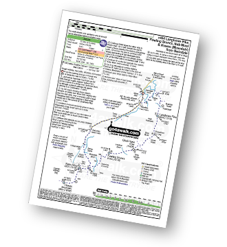
Route Summary:
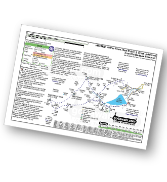
Wet Sladdale Reservoir - Poor Hag Wood - Poorhag Gill - Wetsleddale Moor Lunch House - Howe Gill - The Shap Fells - Gray Bull - Sherry Gill - Sleddale Pike - Wasdale Pike - Great Yarlside - Great Saddle Crag - Ulthwaite Rigg - Scam Matthew - High Wether Howe - Haskew Tarn - Seat Robert - Gambling Crag - Willy Winder Hill - Great Ladstones - Bleak Hill - Willy Fold - White Crag - Michael Moss - Sleddale Hall - Sleddale Beck - Wet Sladdale Reservoir.
|
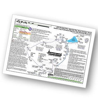
Vital Statistics:
| Length: | 8.25 miles (13 km) |
| Ascent: | 1,572ft (479m) |
| Time: | 4½ hrs |
| Grade: |  |
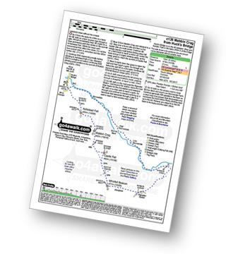
Route Summary:
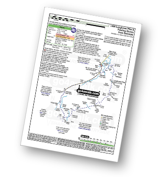
Huck's Bridge - Ashstead Fell - Mabbin Crag - Castle Fell - Whinfell Beacon - Low Borrowdale - Borrow Beck - High Borrowdale - Borrowdale - Huck's Bridge
|
Vital Statistics:
| Length: | 10.5 miles (17 km) |
| Ascent: | 1,411ft (430m) |
| Time: | 2.25hrs |
| Grade: | |
Route Summary:
Wet Sleddale Reservoir - Poor Hag Wood - Poorhag Gill - Wetsleddale Moor Lunch House - Howe Gill - The Shap Fells - Gray Bull - Sherry Gill - Sleddale Pike - Wasdale Pike - Great Yarlside - Great Saddle Crag - Ulthwaite Rigg - Sleddale Hall - Michael Moss - Sleddale Beck - Wet Sleddale Reservoir
|
Vital Statistics:
| Length: | 7.75 miles (12.5 km) |
| Ascent: | 1,483ft (452m) |
| Time: | 4½ hrs |
| Grade: | |
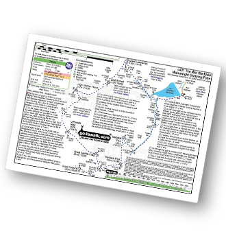
Route Summary:
Hazel Shaw Parking Area - Rosgill Moor - Scalebarrow Knott - Harper Hills - Low Goat Gill - Long Rigg - Powley's Hill - Hare Shaw - Woodhowe Moss - Kit Crag (Naddle Forest) - Wallow Crag (Naddle Forest) - Hugh's Laithes Pike - Hugh's Laithes Pike (North East Top) - Highfield Crag - Naddle Farm - Naddle Beck - Mirkside Wood - Scalebarrow Knott - Hazel Shaw Parking Area
|
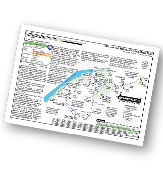
Vital Statistics:
| Length: | 7.25 miles (11.5 km) |
| Ascent: | 1,247ft (380m) |
| Time: | 3.75hrs |
| Grade: |  |
Route Summary:
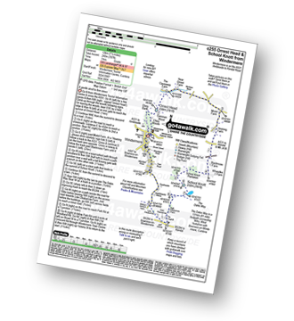
Windermere - Orrest Head - Moorhowe - Dubbs Road - Garburn Road - Longmire Road - Far Orrest Farm - Orrest Head - Windermere
|
Vital Statistics:
| Length: | 7.5 miles (12 km) |
| Ascent: | 787ft (240m) |
| Time: | 3½ hrs |
| Grade: | |
Route Summary:
Windermere - Ellery Woods - Orrest Head - Near Orrest Farm - Mislet Farm - Heaning Farm - Blackmoss Farm - School Knott Plantation - School Knott - The Dales Way - High Cleabarrow Farm - Matson Ground - Heaththwaite Manor - Windermere
|
Vital Statistics:
| Length: | 6.25 miles (10 km) |
| Ascent: | 1,352ft (412m) |
| Time: | 3.75hrs |
| Grade: | |
Route Summary:
Swindale - Swindale Foot Farm - Swindale Beck - Starling Gill - Stubby Hest - Bracken Howe - Thiefstead - Langhowe Pike - High Katelade - Rowantree Crag - Blea Moss - Stone Howe - Glede Howe - Willy Winder Hill - Haskew Beck - Fewling Stones - Swindale Common - Mosedale Beck (Swindale) - Dodd Bottom - Hobgrumble Gill - Swindale Head Farm - Truss Gap - Swindale Foot Farm - Swindale
|
Vital Statistics:
| Length: | 7.75 miles (12.5 km) |
| Ascent: | 1,168ft (356m) |
| Time: | 4 hrs |
| Grade: | |
Route Summary:
Wet Sleddale Reservoir - Selside Beck - Michael Moss - Selside Hall - Scam Matthew - High Wether Howe - Haskew Tarn - Seat Robert - Great Ladstones - Bleak Hill - Willy Fold - White Crag - Peat Hill - Stackhouse Brow - Green Farm - Throney Bank Farm - River Lowther - Cooper Green Farm - eddale Reservoir.
|
Vital Statistics:
| Length: | 5.25 miles (8.5 km) |
| Ascent: | 899ft (274m) |
| Time: | 3 hrs |
| Grade: |  |
See this list of walks, routes & maps in:
Grade Order | Length Order | Time Order | Walk Number or Start Location Order
NB. To reverse (toggle) this order, click Grade Order again


