UK Postcode IV4 - The 30 nearest easy-to-follow, circular walk route maps to you
The thirty nearest easy-to-follow, circular walk route maps to you in UK Postcode IV4 in Walk Grade Order
The UK cities, towns and villages in Highland, Scotland that have IV4 in their UK Postcode include:
• Ardnagrask • Balmore • Beauly • Belladrum • Camault Muir • Cannich • Carnoch • Cougie • Craigdhu • Crask of Aigas • Crelevan • Culburnie • Culligran • Druimkinnerras • Erchless Castle • Eskadale • Fasnakyle • Foxhole • Glassburn • Kilmorack • Kiltarlity • Knockfin • Mauld • Muchrachd • Oldtown of Aigas • Rheindown • Ruilick • Struy • Tomich • Tomnacross •
Not familiar with the area around IV4?
See these 30 nearest walks to UK Postcode IV4 on a google map
   |
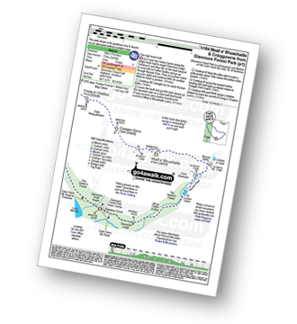
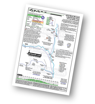
Vital Statistics:
| Length: | 16.5 miles (26.5 km) |
| Ascent: | 5,415ft (1,045m) |
| Time: | 11½ hrs |
| Grade: |  |
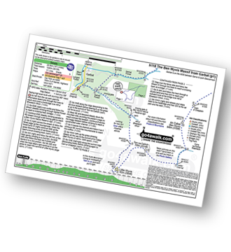
Route Summary:
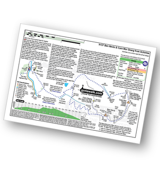
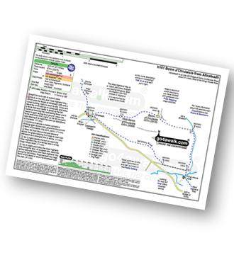
Garbat - Garbat Forest - Allt a' Bhealaich Mhoir - Ben Wyvis Nature Reserve - Little Wyvis - Tom na Caillich - Coire na Feithe Riabhaich - An Cabar (Ben Wyvis) - Carn a' Chaiptein - Ben Wyvis (Glas Leathad Mor) - Coire Nan Con - Bealach Tom a' Choinnich - Glas Choire - Choire Mhic Fhearchair - Choire Lochain - Glas Leathad Beag (Ben Wyvis) - Choire Lochain - Choire Mhic Fhearchair - Tom a' Choinnich (Ben Wyvis) - Coire Dubh - Allt a' Choire Dhuibh - Garbat Forest - Garbat
|
Vital Statistics:
| Length: | 2.5 miles (4 km) |
| Ascent: | 407ft (124m) |
| Time: | 1½ hrs |
| Grade: |  |
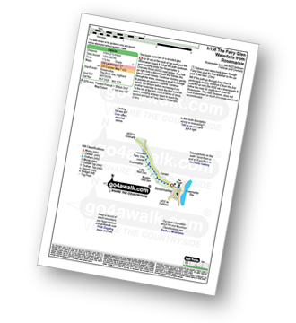
Route Summary:
Rosemarkie - The Black Isle - Rosemarkie Burn - Fairy Glen - Muckle Red Den - Little Red Den - Drummarkie - Fairy Glen Waterfalls - Drummarkie - Little Red Den - Muckle Red Den - Fairy Glen - Rosemarkie Burn - Rosemarkie - The Black Isle.
|
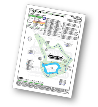
Vital Statistics:
| Length: | 4.75 miles (7.5 km) |
| Ascent: | 197ft (60m) |
| Time: | 2 hrs |
| Grade: | |
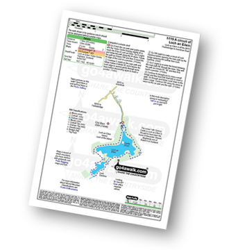
Route Summary:
Loch An Eilein Visitor Centre - Rothiemurchus Loch an Eilein - Loch Gamhna - Loch An Eilein Visitor Centre - Rothiemurchus.
|
Vital Statistics:
| Length: | 5.25 miles (8.5 km) |
| Ascent: | 1,666ft (508m) |
| Time: | 3.75hrs |
| Grade: |  |
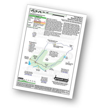
Route Summary:
Glenmore Forest Park Visitor Centre - Meall a' Bhuachaille - Ryvoan Bothy - An Lochan Uaine - Glenmore Lodge - Glenmore Forest Park Visitor Centre
|
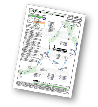
Vital Statistics:
| Length: | 10 miles (16 km) |
| Ascent: | 2,425ft (739m) |
| Time: | 6 hrs |
| Grade: |  |
Route Summary:
Glenmore Forest Park Visitor Centre - Glenmore Lodge - Allt na Feithe Duibhe - An Lochan Uaine - Ryvoan Pass - Ryvoan Bothy - Meall a' Bhuachaille - Creagan Gorm - Coire Beag-ghleann - Creag a' Chaillich - Craiggowrie - The Queen's Forest - Badaguish - Loch Morlich - Glenmore Forest Park Visitor Centre
|
Vital Statistics:
| Length: | 8.25 miles (13 km) |
| Ascent: | 745ft (244m) |
| Time: | 3.75hrs |
| Grade: | |
Route Summary:
Glenmore Forest Park Visitor Centre - Abhainn Ruigh-eunachan - Loch Morlich - River Luineag - The Queen's Forest - Badaguish Outdoor Centre - Glenmore Forest Park Visitor Centre
|
Vital Statistics:
| Length: | 15 miles (24 km) |
| Ascent: | 3,052ft (930m) |
| Time: | 8½ hrs |
| Grade: |  |
Route Summary:
Glenmore Lodge - Allt na Feithe Duibhe - An Lochan Uaine - Ryvoan Pass - River Nethy - Bynack Stable - Bynack More - Little Barns of Bynack - A' Choinneach (Bynack More) - Allt a' Choire Dherg - Bynack Beg (Bynack More) - Strath Nethy - Bynack Stable - Ryvoan Pass - Glenmore Lodge
|
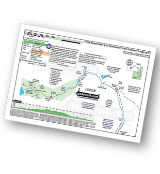
Vital Statistics:
| Length: | 11 miles (17.5 km) |
| Ascent: | 1,159ft (353m) |
| Time: | 5 hrs |
| Grade: |  |
Route Summary:
Glenmore Lodge - Allt na Feithe Duibhe - An Lochan Uaine - Ryvoan Pass - Loch a' Gharbh-choire - Bynack Stable - River Nethy - Abernethy Forest - Ryvoan Bothy - Ryvoan Pass - Glenmore Lodge
|
Vital Statistics:
| Length: | 8.5 miles (13.5 km) |
| Ascent: | 571ft (174m) |
| Time: | 3.75hrs |
| Grade: |  |
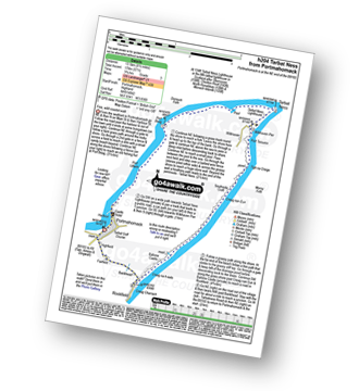
Route Summary:
Portmahomack - Port Uilleim - Port Beag - Tarbat Ness - Tarbetness Lighthouse - Wilkhaven Pier - Port Tarsuinn - Tigh na Creige - Creag Nan Eun - Ballone Castle - Creag na H-eala - Rockfield - Bankhead - Fairfield (Tarbat Ness) - Highfield - Portmahomack
|
Vital Statistics:
| Length: | 4 miles (6.5 km) |
| Ascent: | 2,104ft (641m) |
| Time: | 3.75hrs |
| Grade: | |
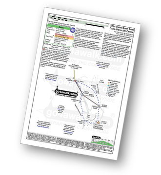
Route Summary:
Cairn Gorm Ski Centre - Shieling Station - Fiacaill a' Choire Chais - Cairn Gorm (Cairngorms) - Ptarmigan Station - Sron An Aonaich - Cairn Gorm Ski Centre
|
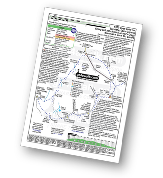
Vital Statistics:
| Length: | 7.25 miles (11.5 km) |
| Ascent: | 2,609ft (795m) |
| Time: | 5.25hrs |
| Grade: | |
Route Summary:
Cairn Gorm Ski Centre - Shieling Station - Fiacaill a' Choire Chais - Stob Coire an t-Sneachda (Cairn Gorm) - Fiacaill Choire an t-Sneachda - Cairn Lochan - Miadan Creag An Lech-choin - Creag An Leth-choin (Lurcher's Crag) - Cairn Gorm Ski Centre
|
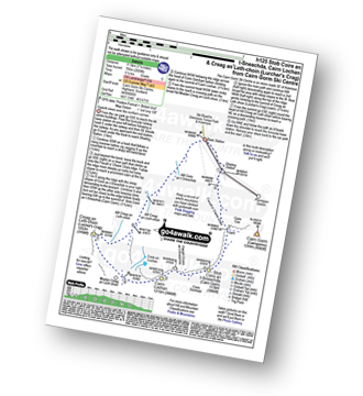
Vital Statistics:
| Length: | 8.75 miles (14 km) |
| Ascent: | 3,036ft (925m) |
| Time: | 6.25hrs |
| Grade: | |
Route Summary:
Cairn Gorm Ski Centre - Sron An Aonaich - Ptarmigan Station - Cnap Coire na Spreidhe (Cairn Gorm) - Cairn Gorm (Cairngorms) - Coire Cas - Fiacaill a' Choire Chais - Stob Coire an t-Sneachda (Cairn Gorm) - Fiacaill Choire an t-Sneachda - Cairn Lochan - Miadan Creag An Lech-choin - Creag An Leth-choin (Lurcher's Crag) - Cairn Gorm Ski Centre
|
Vital Statistics:
| Length: | 12.75 miles (20.5 km) |
| Ascent: | 3,243ft (988m) |
| Time: | 8 hrs |
| Grade: | |
Route Summary:
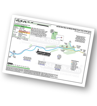
Corrour Bothy - Lairig Ghru - River Dee - Glen Dee - Coachan Roibidh - Coire Coachan Roibidh - Beinn Bhrotain (East Top) - Coire an t-Sneachda - Beinn Bhrotain - Core Cath Nam Fionn - Leac Ghorm - Monadh Mor - Allt Luineas - Loch Nan Stuirteng - Allt Clais an t-Sabhail - Allt A`Coire Cath Nam Fionn - Glen Geusachan - Geusachan Burn - River Dee - Corrour Bothy - Lairig Ghru.
|
Vital Statistics:
| Length: | 11.5 miles (18.5 km) |
| Ascent: | 4,260ft (1,298m) |
| Time: | 8½ hrs |
| Grade: | |
Route Summary:
Corrour Bothy - Lairig Ghru - Allt a' Coire Odhar - Coire Odhar - The Devil's Point - Stob Coire an t-Saighdeir (Cairn Toul) - Cairn Toul (Carn an t-Sabhail) - Coire An an t-Sabhail - Sgor An Lochain Uaine (The Angel's Peak) - Garbh Core Mor - Carn na Criche (Braeriach) - Clais Luinneag - Loch Nan Stuirteng - Allt Clais an t-Sabhail - Allt a' Core Cath Nam Fionn - Glen Geusachan - Geusachan Burn - River Dee - Corrour Bothy - Lairig Ghru.
|
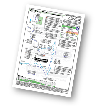
Vital Statistics:
| Length: | 11.5 miles (18.5 km) |
| Ascent: | 3,919ft (1,194m) |
| Time: | 8½ hrs |
| Grade: | |
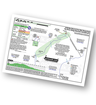
Route Summary:
The Nevis Range Mountain Gondola - Sgurr Finnisg-aig - Carn Beag Dearg (Carn Mor Dearg) - Carn Dearg Meadhonach (Carn Mor Dearg) - Carn Mor Dearg - Carn Mor Dearg Arete (CMD Arete) - Ben Nevis - Carn Dearg (Ben Nevis) (North West Top) - The Ben Nevis Tourist Path - Coire Ghaimhnean (Five Finger Gully) - Lochan Meall an t-Suidhe - Leanachan Forest - The Nevis Range Mountain Gondola
Not familiar with the area around IV4?
See these 30 nearest walks to UK Postcode IV4 on a google map
|
Vital Statistics:
| Length: | 10.25 miles (16.5 km) |
| Ascent: | 4,424ft (1,348m) |
| Time: | 8½ hrs |
| Grade: | |
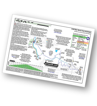
Route Summary:
Fort William - Achintee - Glen Nevis - The Ben Nevis Tourist Path - The Pony Track - Allt na H-Urchaire (Red Burn) - Lochan Meall an t-Suidhe - Coire Ghaimhnean (Five Finger Gully) - Ben Nevis - The Ben Nevis Tourist Path - Achintee - Fort William
|
Vital Statistics:
| Length: | 12.25 miles (19.5 km) |
| Ascent: | 5,333ft (1,625m) |
| Time: | 10 hrs |
| Grade: | |
Route Summary:
Fort William - Achintee - Glen Nevis - The Ben Nevis Tourist Path - The Pony Track - Allt na H-Urchaire (Red Burn) - Lochan Meall an t-Suidhe - Allt a' Mhuilinn - Carn Dearg Meadhonach (Carn Mor Dearg) - Carn Mor Dearg - Carn Mor Dearg Arete (CMD Arete) - Ben Nevis - Ben Nevis Tourist Path - Coire Ghaimhnean (Five Finger Gully) - Lochan Meall an t-Suidhe - Achintee - Fort William
|
Vital Statistics:
| Length: | 7 miles (11 km) |
| Ascent: | 610ft (186m) |
| Time: | 3.25hrs |
| Grade: | |
|
Vital Statistics:
| Length: | 8.25 miles (13 km) |
| Ascent: | 1,113ft (339m) |
| Time: | 4 hrs |
| Grade: | |
Route Summary:
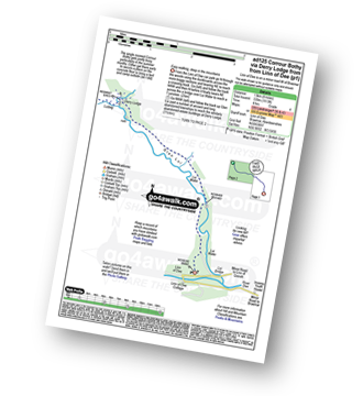
Linn of Dee - Lui Water - Glen Lui - Derry Lodge - Luibeg - Glen Luibeg - Luibeg Bridge - Allt Preas Nam Meirleach - River Dee - Corrour Bothy - Lairig Ghru.
|
Vital Statistics:
| Length: | 6 miles (9.5 km) |
| Ascent: | 712ft (217m) |
| Time: | 3 hrs |
| Grade: | |
Route Summary:
Glenfinnan - Ghlean Fhionnainn - Glenfinnan Monument - Lochan Port na Creige - Torran Glubhals - Loch Shiel - Rubha Nan Gamhna - Allt na H-Innse Buidhe - Guesachan - Allt Coire Ghiubhsachain - Loch Shiel - Rubha Nan Gamhna - Glenfinnan Monument - Glenfinnan
|
Vital Statistics:
| Length: | 5 miles (8 km) |
| Ascent: | 414ft (126m) |
| Time: | 2½ hrs |
| Grade: |  |
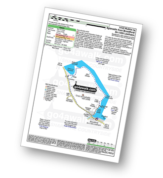
Route Summary:
Broadford/ an t-Ath Leathann - Isle of Skye - Rubh' An Eireannaich - Rubha na Sgianadin - Camas na Sgianadin - Broadford/ an t-Ath Leathann - Isle of Skye.
|
Vital Statistics:
| Length: | 6.25 miles (10 km) |
| Ascent: | 1,158ft (353m) |
| Time: | 3½ hrs |
| Grade: | |
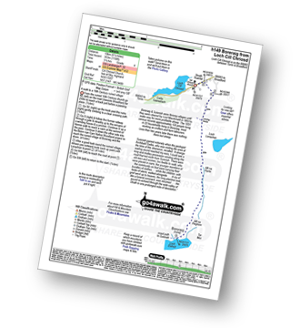
Route Summary:
Loch Cill Chriosd - Isle of Skye - Cill Chriosd Church - Strath Surreal - Loch Lonachan - Allt na Pairte - Allt na Pighinn - Boreraig (ruined Village) - Loch Lonachan - Strath Surreal - Loch Cill Chriosd - Isle of Skye.
|
Vital Statistics:
| Length: | 10.75 miles (17 km) |
| Ascent: | 4,398ft (426m) |
| Time: | 5.25hrs |
| Grade: | |
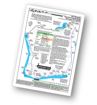
Route Summary:
Loch Cill Chriosd - Isle of Skye - Cill Chriosd Church - Strath Surreal - Loch Lonachan - Allt na Pairte - Allt na Pighinn - Boreraig (ruined Village) - Loch Eishort - Leoid (Carn Dearg) - Suisnish (ruined Village) - Glen Boreraig. Loch Slapin - Camas Malag - Coille Gaireallach - Loch Cill Chriosd - Isle of Skye.
|
Vital Statistics:
| Length: | 8.75 miles (14 km) |
| Ascent: | 4,050ft (1,234m) |
| Time: | 7½ hrs |
| Grade: |  |
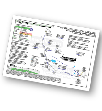
Route Summary:
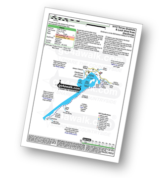
Lairig Unapool - Allt Sgiathaig - Spidean Coinich (Quinag) - Lochan Ruadh - Bealach A Connaich - Sail Ghorm (Quinag) - Bealach A Connaich - Sail Gharbh (Quinag) - Lochan Bealach Connaich - Allt Sgiathaig - Lairig Unapool
|
Vital Statistics:
| Length: | 6.5 miles (10.5 km) |
| Ascent: | 2,227ft (679m) |
| Time: | 4½ hrs |
| Grade: | |
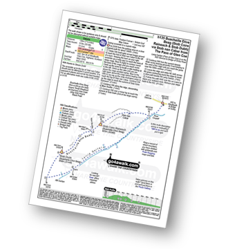
Route Summary:
Altnafeadh - The Pass of Glen Coe - Stob Beinn a' Chrulaiste - Beinn a' Chrulaiste - The Kings House Hotel - The Old Military Road - The West Highland Way - Altnafeadh - The Pass of Glen Coe.
|
Vital Statistics:
| Length: | 4.25 miles (6.5 km) |
| Ascent: | 2,491ft (759m) |
| Time: | 4 hrs |
| Grade: | |
Route Summary:
Altnafeadh - The Pass of Glencoe - Lagangarbh Cottage - Allt Coire na Tulaich - Coire na Tulaich - Buachaille Etive Mor (Stob Dearg) - Coire na Tulaich - Allt Coire na Tulaich - Lagangarbh Cottage - The Pass of Glencoe - Altnafeadh.
|
Vital Statistics:
| Length: | 8.25 miles (13 km) |
| Ascent: | 3,814ft (1,162m) |
| Time: | 7 hrs |
| Grade: | |
Route Summary:
The Pass of Glencoe - A82 - Altnafeadh - Lagangarbh Cottage - Allt Coire na Tulaich - Coire na Tulaich - Buachaille Etive Mor (Stob Dearg) - Feadan Ban (Buachaille Etive Mor) - Stob na Doire (Buachaille Etive Mor) - Stob Coire Altruim (Buachaille Etive Mor) - Stob na Broige (Buachaille Etive Mor) - Lairig Gartain - A82 The Pass of Glencoe.
|
Vital Statistics:
| Length: | 8.25 miles (13 km) |
| Ascent: | 2,993ft (912m) |
| Time: | 6 hrs |
| Grade: | |
Route Summary:
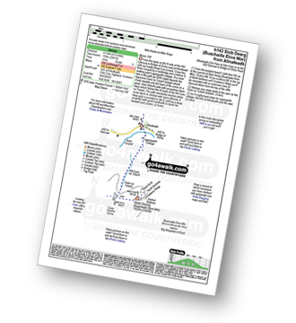
The Pass of Glencoe - Stob Coire Raineach (Buachaille Etive Beag) - Buachaille Etive Beag (Stob Dubh) - Lairig Gartain - The Pass of Glencoe
|
Vital Statistics:
| Length: | 7.5 miles (12 km) |
| Ascent: | 3,016ft (919m) |
| Time: | 6½ hrs |
| Grade: | |
Route Summary:
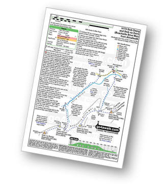
The Pass of Glencoe - Stob Nan Cabar - Stob Coire Raineach (Buachaille Etive Beag) - Buachaille Etive Beag (Stob Dubh) - Lairig Gartain - The Pass of Glencoe
|
Vital Statistics:
| Length: | 10.25 miles (16.5 km) |
| Ascent: | 3,929ft (1,197m) |
| Time: | 7.75hrs |
| Grade: | |
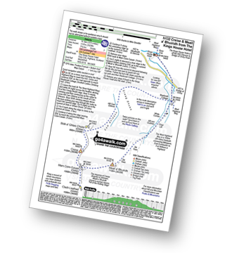
Route Summary:
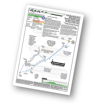
The Pass of Glencoe - The Kings House Hotel - Blackrock Cottage - Cam Ghleann - Stob a' Ghlais Choire (Creise) - Creise - Mam Coire Easain (Creise) - Clach Leathad (Creise) - Meall a' Bhuiridh - Allt Nan Giubhas - White Corries - Blackrock Cottage - The Kings House Hotel - The Pass of Glencoe
Not familiar with the area around IV4?
See these 30 nearest walks to UK Postcode IV4 on a google map


