
![]()
Tom a' Choinnich (Ben Wyvis)
953m (3128ft)
The Easter Ross & Cromarty Firth Hills, Ullapool to The Moray Firth, Highland, Scotland

Not familiar with this top?
You can walk/hike to the top of Tom a' Choinnich (Ben Wyvis) by using this easy‑to‑follow route map:
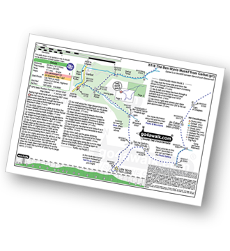
Walk h118 The Ben Wyvis Massif from Garbat
Testing high level route with stunning 360º views
   |
|---|
Vital Statistics:
| Length: | 16.5ml (26.5km) |
|---|---|
| Ascent: | 5,415ft (1,045m) |
| Time: | 11½ hrs |
| Grade: |  (Very Hard) (Very Hard) |
Route Summary:
Garbat - Garbat Forest - Allt a' Bhealaich Mhoir - Ben Wyvis Nature Reserve - Little Wyvis - Tom na Caillich - Coire na Feithe Riabhaich - An Cabar (Ben Wyvis) - Carn a' Chaiptein - Ben Wyvis (Glas Leathad Mor) - Coire Nan Con - Bealach Tom a' Choinnich - Glas Choire - Choire Mhic Fhearchair - Choire Lochain - Glas Leathad Beag (Ben Wyvis) - Choire Lochain - Choire Mhic Fhearchair - Tom a' Choinnich (Ben Wyvis) - Coire Dubh - Allt a' Choire Dhuibh - Garbat Forest - Garbat
See Tom a' Choinnich (Ben Wyvis) and the surrounding tops on our free-to-access 'Google Style' Peak Bagging Maps:
The Easter Ross & Cromarty Firth Hills area of Scottish Region 15: Ullapool to The Moray Firth
Less data - quicker to download
Scottish Region 15: Ullapool to The Moray Firth
Less data - quicker to download
A go4awalk.com downloadable Peak Bagging Map in PDF format featuring Tom a' Choinnich (Ben Wyvis) should be available soon.
Free-to-access Interactive Walk Planning Maps:
1:25,000 scale OS Explorer Map (orange/yellow covers):
An Interactive Walk Planning Map for OS Explorer 437 Ben Wyvis & Strathpeffer is not currently available
1:50,000 scale OS Landranger Map (pink/magenta covers):
An Interactive Walk Planning Map for OS Landranger 20 Beinn Dearg & Loch Broom, Ben Wyvis is not currently available
 Fellow go4awalkers who have already walked, climbed, scaled, summited, hiked & bagged Tom a' Choinnich (Ben Wyvis)
Phyllis Mcgibbon has walked, climbed & bagged Tom a' Choinnich (Ben Wyvis).
To add (or remove) your name and experiences on this page - Log On and edit your Personal Mountain Bagging Record
Send us your photographs and pictures on, of, or from Tom a' Choinnich (Ben Wyvis)
If you would like to add your walk photographs and pictures to this page, please send them as email attachments (configured for any computer) along with your name to:
and we shall do our best to publish them.
(Guide Resolution = 300dpi. At least = 660pixels (wide) x 440 pixels (high).)

You can also submit photos via our Facebook Page.
NB. Please indicate where each photo was taken and whether you wish us to credit your photos with a Username or your First Name/Last Name.


