35 easy-to-follow walk, route maps of all grades on OS Landranger Map 109 Manchester, Bolton & Warrington
Thirty-five easy-to-follow walk, route maps of all grades on OS Landranger Map 109 Manchester, Bolton & Warrington in Walk Grade OrderTap/mouse over a coloured circle (1-3 easy walks, 4-6 moderate walks, 7-9 hard walks) and click to select.
You can use these checkboxes to show only the grades of walk you are interested in:-
Thirty-five easy-to-follow walk, route maps of all grades on OS Landranger Map 109 Manchester, Bolton & Warrington in Walk Grade Order
Scroll down the list of walks below & click on each walk title (in blue) to locate it on the map above.
See this list of walks, routes & maps in:
Grade Order | Length Order | Time Order | Walk Number or Start Location Order
NB. To reverse (toggle) this order, click Grade Order again
   |
Vital Statistics:
| Length: | 11 miles (17.5 km) |
| Ascent: | 269ft (82m) |
| Time: | 4½ hrs |
| Grade: |  |
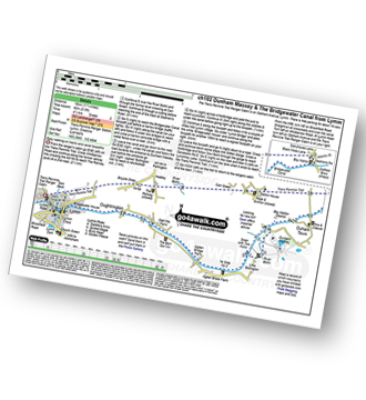
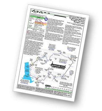
Route Summary:
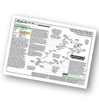
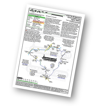
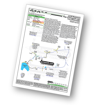
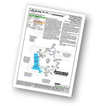
The Trans Pennine Trail (Lymm) - Lymm - Carr Green - Oldfield Brow - Altrincham - The Bridgewater Canal - The Cheshire Ring Canal Walk - Dunham Town - Dunham Massey - Little Bollington - The Bridgewater Canal - The Cheshire Ring Canal Walk - Agden Bridge - Oughtrington - Lymm Village - Slitten Gorge - The Trans Pennine Trail - Lymm.
|
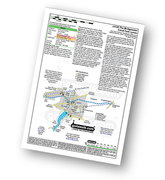
Vital Statistics:
| Length: | 8.5 miles (13.5 km) |
| Ascent: | 453ft (138m) |
| Time: | 3½ hrs |
| Grade: | |
Route Summary:
Hale (near Altrincham) - The River Bollin - The Bollin Valley Way - Coppice Farm - Ryecroft Farm - Birkin Farm - Birtles Farm - New Mills - Breach House Farm - Higherhouse Farm - The River Bollin - Ross Mill - Hale.
|
Vital Statistics:
| Length: | 5.25 miles (8.5 km) |
| Ascent: | 246ft (75m) |
| Time: | 2.25hrs |
| Grade: |  |
Route Summary:
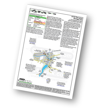
The Trans Pennine Trail (Lymm) - Lymm - The Bridgewater Canal - The Cheshire Ring Canal Walk - Lymm Village - The Dingle - Lymm Dam - The Bongs - Crosfield Bridge - Oughtrington - The Bridgewater Canal - The Cheshire Ring Canal Walk - Rushgreen - Slitten Gorge - The Trans Pennine Trail - Lymm.
|
Vital Statistics:
| Length: | 6.75 miles (11 km) |
| Ascent: | 370ft (110m) |
| Time: | 3 hrs |
| Grade: | |
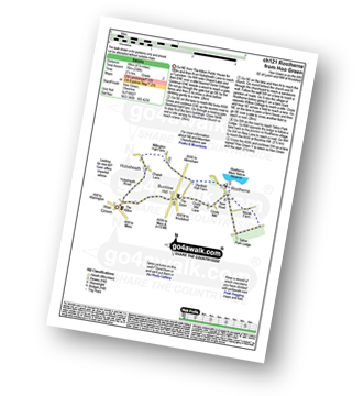
Route Summary:
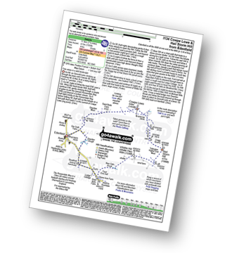
Hoo Green - Hulseheath - Gorse Barn - Millington Brook - Agden Brook - Denfield Hall Farm - Rostherne Brook - Rostherne - Rostherene Mere Nature Reserve - Marsh Farm - Rostherne - Cicely Mill - Bucklow Hill - Hulseheath - Hoo Green
|
Vital Statistics:
| Length: | 6.5 miles (10.5 km) |
| Ascent: | 167ft (51m) |
| Time: | 2.75hrs |
| Grade: | |
Route Summary:
Lindow Common - Wilmslow - Lindow Moss - Morley Green - Rossmere - Saltersley Hall Farm - Mobberley Golf Club - Graveyard Farm - Knolls Green - Paddockhill - Plough and Flail - Racecourse Farm - Lindow Common - Wilmslow.
|
Vital Statistics:
| Length: | 3.75 miles (6 km) |
| Ascent: | 204ft (62m) |
| Time: | 2 hrs |
| Grade: |  |
Route Summary:
The Trans Pennine Trail (Lymm) - Lymm - The Bridgewater Canal - The Cheshire Ring Canal Walk - Lymm Village - The Dingle - Lymm Dam - The Bongs - Crosfield Bridge - Lymm Dam - The Dingle - Lymm Cross - The Bridgewater Canal - The Cheshire Ring Canal Walk - Slitten Gorge - The Trans Pennine Trail - Lymm.
|
Vital Statistics:
| Length: | 5.5 miles (9 km) |
| Ascent: | 499ft (152m) |
| Time: | 2.75hrs |
| Grade: | |
Route Summary:
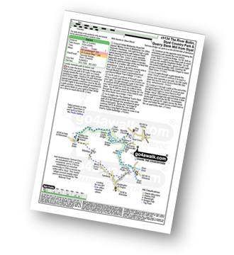
Twinnies Bridge - Wilmslow - Moss Grove Farm - Morely - The River Bollin - Styal Country Park - Giant's Castle Bridge - Oxbrow Bridge - Kingfisher Bridge - Norcliffe Church - Styal Cross - Styal - Quarry Bank Mill - Twinnies Bridge - Wilmslow.
|
Vital Statistics:
| Length: | 5.5 miles (8.5 km) |
| Ascent: | 158ft (48m) |
| Time: | 2.25hrs |
| Grade: | |
Route Summary:
Arley - Arley Hall - Arley Brook - Hollies Farm - Antrobus - Budworth Heath - Great Budworth - Stockley Farm - Arley
|
Vital Statistics:
| Length: | 6.25 miles (10 km) |
| Ascent: | 400ft (122m) |
| Time: | 2.75hrs |
| Grade: | |
Route Summary:
Higher Walton - The Bridgewater Canal - Hillfoot Farm - The Mersey Valley Way - Bellfield Farm - Dennow Cottage - Dennow Farm - Hatton - Blue Coat Farm - Row's Wood - Moore - The Bridgewater Canal - Walton Hall - Higher Walton
|
Vital Statistics:
| Length: | 9.75 miles (15.5 km) |
| Ascent: | 9ft (409m) |
| Time: | 5 hrs |
| Grade: |  |
Route Summary:
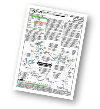
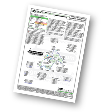
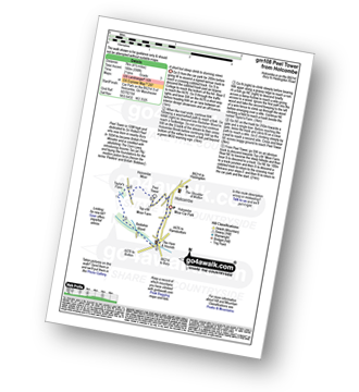
Nelson Pit Visitors Centre - Higher Poynton - The Macclesfield Canal - The Cheshire Ring Canal Walk - Wood Lanes - Adlington Basin - Lockgate Farm - The North Cheshire Way - Harrop Brow - Birchencliff Farm - Keeper's Cottage - Dale Top - Sponds Moor - The Gritstone Trail - Sponds Hill - Bowstonegate Farm - Bow Stones - Higher Moor - Lyme Park Country Park - Lantern Wood - The Cage - Lyme Hall - Fallow Deer Park - The Lime Avenue - Lyme Park Car Park - Windgather Farm - Haresteads Farm - Nelson Pit Visitors Centre - Higher Poynton.
|
Vital Statistics:
| Length: | 4.5 miles (7 km) |
| Ascent: | 190ft (58m) |
| Time: | 1.75hrs |
| Grade: | |
Route Summary:
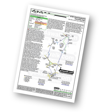
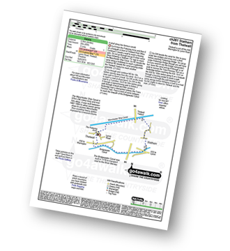
Thelwall - Manchester Ship Canal - Thelwall Viaduct - Statham - The Bridgewater Canal - The Cheshire Ring Canal Walk - Thelwall
|
Vital Statistics:
| Length: | 7 miles (11 km) |
| Ascent: | 824ft (251m) |
| Time: | 3.25hrs |
| Grade: |  |
Route Summary:
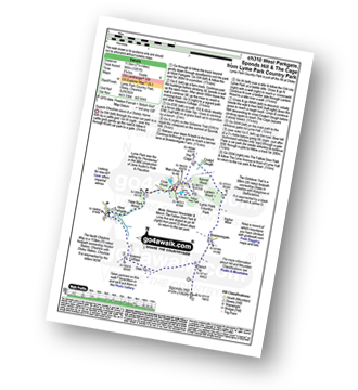
Nelson Pit Visitors Centre - Higher Poynton - The Macclesfield Canal - The Cheshire Ring Canal Walk - Wood Lanes - Adlington Basin - Lockgate Farm - The North Cheshire Way - Harrop Brow - West Parkgate - Lyme Park Country Park - Lyme Park Car Park - The Cage - Lyme Hall - Fallow Deer Park - The Lime Avenue - Lyme Park Car Park - Windgather Farm - Haresteads Farm - Nelson Pit Visitors Centre - Higher Poynton.
|
Vital Statistics:
| Length: | 4.5 miles (7 km) |
| Ascent: | 715ft (218m) |
| Time: | 2½ hrs |
| Grade: | |
Route Summary:
Lyme Park Car Park - Lyme Park Country Park - Pursefield Wood - Paddock Cottage,Knightslow Wood, - Higher Moor - Lantern Wood - The Cage - The North Cheshire Way - Lyme Hall - Lyme Park Car Park
|
Vital Statistics:
| Length: | 7.25 miles (11.5 km) |
| Ascent: | 1,201ft (366m) |
| Time: | 3.75hrs |
| Grade: | |
Route Summary:
Lyme Park Car Park - Crow Wood - Hase Bank Wood - West Parkgate - The North Cheshire Way - Keepers' Cottage - Dale Top - Sponds Moor - The Gritstone Trail - Sponds Hill - Bow Stones - Bowstonegate Farm - Lyme Park Country Park - Lantern Wood - The Cage - Fallow Deer Park - The Lime Avenue - Lyme Park Car Park
|
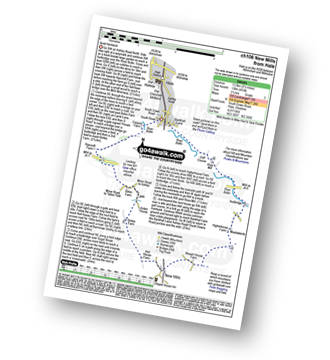
Vital Statistics:
| Length: | 9.5 miles (15 km) |
| Ascent: | 1,696ft (517m) |
| Time: | 5.25hrs |
| Grade: |  |
Route Summary:
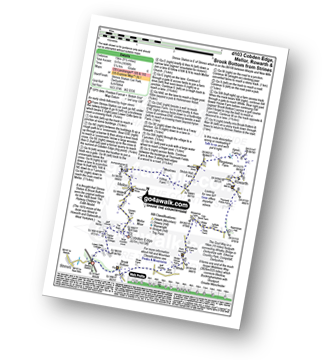
Strines Station - Lower Cliffe Cottage - Higher Banks Cottage - Cobden Edge - Mellor Moor - Mellor - Mellor Church - Hilltop Farm - Shiloh Hall Farm - Ringstones Farm - Ayton Farm - Rowarth - Thornsett Fields Farm - New Mills - Whitle - Brook Bottom - The Goyt Way - The Midshires Way - Strines Station
|
Vital Statistics:
| Length: | 6 miles (9.5 km) |
| Ascent: | 236ft (72m) |
| Time: | 2½ hrs |
| Grade: | |
Route Summary:
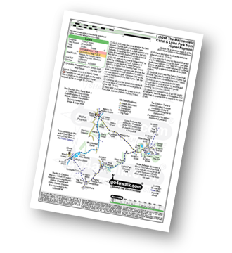
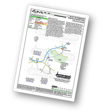
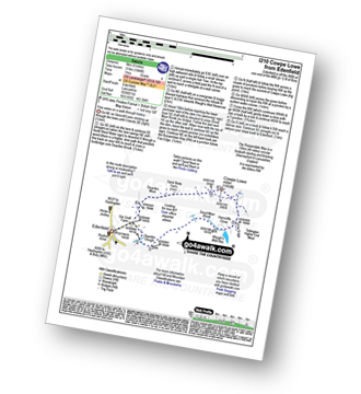
Dunham Town - The Bridgewater Canal - The Cheshire Ring Canal Walk - Agden Bridge - Agden Brook Farm - Arthill Farm - Reddy Lane Cottage - Little Bollington - Dunham Massey Park - Dunham Park - Dunham Town
|
Vital Statistics:
| Length: | 6.25 miles (10 km) |
| Ascent: | 1,017ft (310m) |
| Time: | 3½ hrs |
| Grade: | |
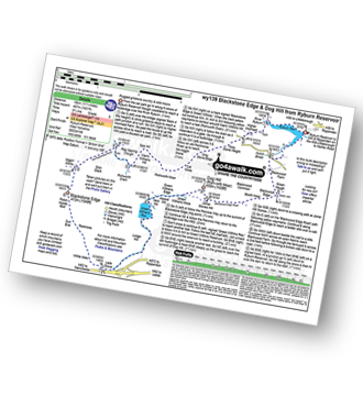
Route Summary:
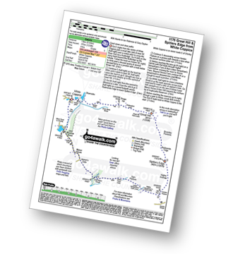
Hollingworth Lake Car Park - Ealees Brook - Brearley - Whittaker Golf Club - Lydgate - Blackstone Edge Pasture - The Pennine Way - Aiggin Stone - Blackstone Edge - Robin Hood Bed - Broad Head Drain - Hoar Edge - Clegg Moor - Dry Moor - Benny Hill - Syke Nab - Hollingworth Lake.
|
Vital Statistics:
| Length: | 4 miles (6.5 km) |
| Ascent: | 590ft (180m) |
| Time: | 2.25hrs |
| Grade: | |
Route Summary:
Holcombe Moor Car Park - Branch Rd - Top O'th' Moor Farm - Peel Tower - Taylor's Farm - Redisher Wood - Holcombe Brook - Holcombe Moor Car Park
|
Vital Statistics:
| Length: | 10 miles (16 km) |
| Ascent: | 1,115ft (340m) |
| Time: | 4½ hrs |
| Grade: | |
Route Summary:
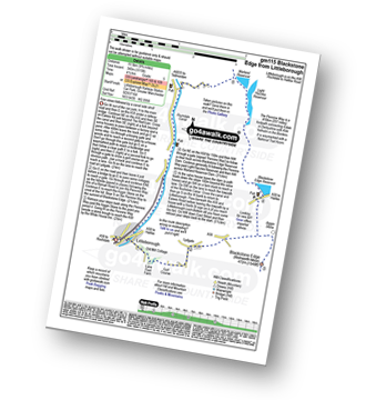
Littleborough - Rochdale Way - Ealees Road - Ealees Brook - Brearley - Whittaker Colf Club - Lydgate - Blackstone Edge Pasture - Aiggin Stone - The Pennine Way - Blackstone Edge Moor - Blackstone Edge Reservoir - Chelburn Moor - Utley Edge - Light Hazzles Reservoir - Warland Reservoir - Warland - Rochdale Canal - Summit - Timbercliffe - Claderbrook - Littleborough
|
Vital Statistics:
| Length: | 8.5 miles (13.5 km) |
| Ascent: | 1,549ft (472m) |
| Time: | 4.75hrs |
| Grade: | |
Route Summary:
Watergrove Reservoir - Wardle - Ramsden Road - The Pennine Bridleway - Crook Moor - Higher Slack Brook - Rough Hill (Shore Moor) - Freeholds Top - Trough Edge End - The Rossendale Way - Trough Edge - Deacon Pasture - Hades Hill - Hades - Middle Hill (Whitworth) - Brown Wardle Hill - Long Shoot Clough - Watergrove Reservoir - Wardle.
|
Vital Statistics:
| Length: | 7 miles (11 km) |
| Ascent: | 1,615ft (492m) |
| Time: | 4.25hrs |
| Grade: | |
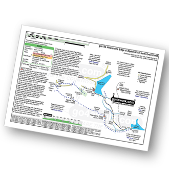
Route Summary:
Dove Stone Reservoir - Greenfield - The Oldham Way - Chew Brook - Chew Reservoir - Stable Stones Brow (Hoarstone Edge) - Alphin Pike - Dove Stone Reservoir
|
Vital Statistics:
| Length: | 9 miles (14.5 km) |
| Ascent: | 131ft (40m) |
| Time: | 3½ hrs |
| Grade: | |
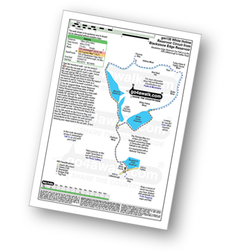
Route Summary:
Blackstone Edge Reservoir - The Pennine Way - Cow Head - Byron Edge - Light Hazzles Edge - White Holme Reservoir - Farther Hill - Little Moor Stone - White Holme Drain - Blake Moor - Middle Moor - Cloven Stone - Turley Moor - Higher House Moor - Bird Nest Hill - Withins Moor - Warland Drain - The Pennine Way - Withins Clough Head - Warland Reservoir - Light Hazzles Reservoir - Utley Edge - Chelburn Moor - Blackstone Edge Reservoir
|
Vital Statistics:
| Length: | 6.75 miles (11 km) |
| Ascent: | 1,050ft (320m) |
| Time: | 3.75hrs |
| Grade: | |
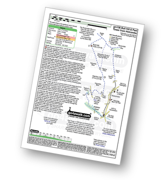
Route Summary:
Holcombe Moor Car Park - Holcombe - Higher Tops - Chatterton Close Farm - Buckden Wood - The Rossendale Way - Beetle Hill - Bull Hill (Holcombe Moor) - Pilgrim's Cross - Harcles Hill - Peel Tower - Taylor's Farm - Redisher Wood - Holcombe Brook - Holcombe Car Park.
|
Vital Statistics:
| Length: | 5.25 miles (8.5 km) |
| Ascent: | 686ft (210m) |
| Time: | 2.75hrs |
| Grade: | |
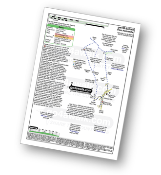
Route Summary:
Holcombe Moor Car Park - Holcombe - Higher Tops - Chatterton Close Farm - Buckden Wood - The Rossendale Way - Beetle Hill - Bull Hill (Holcombe Moor) - Pilgrim's Cross - Harcles Hill - Peel Tower - Top o'th'Moor Farm - Branch Road - Holcombe Moor Car Park
|
Vital Statistics:
| Length: | 4.5 miles (7 km) |
| Ascent: | 893ft (272m) |
| Time: | 2½ hrs |
| Grade: | |
Route Summary:
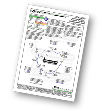
Great House Information Centre - Rivington Hall - Rivington Cottage - Rivington Upper Barn - Pigeon Tower (Rivington Moor) - Rivington Pike - Brown Hill (Rivington Moor) - Higher Knoll - Rivington Lane Car Park - Lever Park - The Castle (Lower Rivington Reservoir) - Lower Rivington Reservoir - Great House Information Centre
|
Vital Statistics:
| Length: | 7.25 miles (11.5 km) |
| Ascent: | 1,355ft (413m) |
| Time: | 4 hrs |
| Grade: | |
Route Summary:
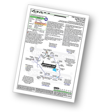
Edenfield - Gin Croft Lane - Dearden Moor - Sand Beds Farm - Cowpe Lowe - The Rossendale Way - Foe Edge - Cowpe Moss - Cragg Quarry - Hail Storm Hill - Tottington Higher End Moor - Whittle Hill - New Gate Brook - Fecit Delf Endm Scout Moss - Turn - Dearden Clough - Edenfield
|
Vital Statistics:
| Length: | 6.25 miles (10 km) |
| Ascent: | 879ft (268m) |
| Time: | 3.25hrs |
| Grade: | |
Route Summary:
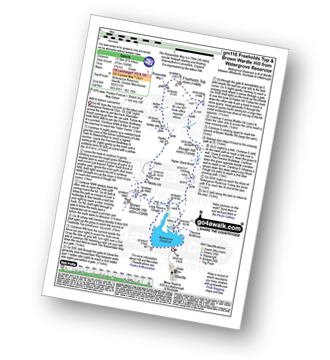
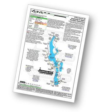
Lower Rivington Reservoir - Rivington - Upper Rivington Reservoir - Pilkington Wood - Street Wood - Yarrow Reservoir - Bradley Wood - Anglezarke Reservoir - High Bullough Reservoir - John Meadow Wood - Heapey Waterman's Cottage - Grey Heights Wood - Heapey Fold Lane - Kays Farm - Waring Fram - Lane Ends (Adlington) - Upper Rivington Reservoir - Lower Rivington Reservoir
|
Vital Statistics:
| Length: | 8.5 miles (13.5 km) |
| Ascent: | 1,753ft (534m) |
| Time: | 4.75hrs |
| Grade: | |
Route Summary:
Cowpe - Greenbridge Car Park - Lenchfold Farm - The Rossendale Way - Cowpe Lowe - Sand Beds Farm - Dearden Moor - Gin Croft Lane - Dearden Clough - Scout Moor Brook - Waugh's Well Reservoir - Horncliffe Close - Foe Edge - Cragg Quarry - Hail Storm Hill - Cowpe Moss - Cragg High Level Tank - Brandwood Moor - Higher Boarsgreave Moor - Lower Boarsgreave Moor - Cowpe,.
|
Vital Statistics:
| Length: | 5.5 miles (8.5 km) |
| Ascent: | 1,113ft (339m) |
| Time: | 3.25hrs |
| Grade: | |
Route Summary:
Rivington Upper Barn - Pigeon Tower (Rivington Moor) - Catter Nab - Noon Hill Slack - Moor Bottom - Winter Hill (Rivington Moor) - Crooked Edge Hill - Two Lads (Rivington Moor) - Pike Cottage - Brown Hill (Rivington Moor) - Rivington Pike - Pigeon Tower (Rivington Moor) - Rivington Upper Barn
|
Vital Statistics:
| Length: | 5.5 miles (8.5 km) |
| Ascent: | 1,093ft (333m) |
| Time: | 3 hrs |
| Grade: | |
Route Summary:
Cowpe - Greenbridge Car Park - Lenchfold Farm - The Rossendale Way - Cowpe Lowe - Cragg Quarry - Hail Storm Hill - Cowpe Moss - Cragg High Level Tank - Brandwood Moor - Higher Boarsgreave Moor - Lower Boarsgreave Moor - Cowpe,.
|
Vital Statistics:
| Length: | 8.25 miles (13 km) |
| Ascent: | 1,230ft (375m) |
| Time: | 4 hrs |
| Grade: | |
Route Summary:
White Coppice - Wheelton Moor - Withnell Moor - Great Hill - Redmonds Edge - Spitlers Edge - Horden Pasture - Lead Mines Clough - Anglezarke Reservoir - White Coppice
|
Vital Statistics:
| Length: | 5 miles (8 km) |
| Ascent: | 1,044ft (318m) |
| Time: | 3 hrs |
| Grade: | |
Route Summary:
Edenfield - Gin Croft Lane - Dearden Moor - Sand Beds Farm - Cowpe Lowe - The Rossendale Way - Foe Edge - Horncliffe Close - Waugh's Well Reservoir - Scout Moor Brook - Dearden Clough - Edenfield
|
Vital Statistics:
| Length: | 7.75 miles (12.5 km) |
| Ascent: | 1,536ft (468m) |
| Time: | 4½ hrs |
| Grade: | |
Route Summary:
Rivington Lane Car Park - Lever Park - The Castle (Lower Rivington Reservoir) - Lower Rivington Reservoir - Great House Information Centre - Rivington Hall - Rivington Cottage - Rivington Upper Barn - Pigeon Tower (Rivington Moor) - Catter Nab - Noon Hill Slack - Moor Bottom - Winter Hill (Rivington Moor) - Crooked Edge Hill - Two Lads (Rivington Moor) - Pike Cottage - Brown Hill (Rivington Moor) - Rivington Pike - Higher Knoll - Rivington Lane Car Park
|
Vital Statistics:
| Length: | 11.25 miles (18 km) |
| Ascent: | 1,631ft (497m) |
| Time: | 5.75hrs |
| Grade: | |
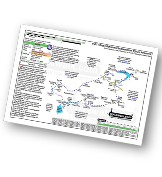
Route Summary:
Ryburn Reservoir - River Ryburn - Higher Wormaid - Grey Stone Height - Cat Moss - Rishworth Moor - Warm Withens Hill - Rishworth Drain - Rag Sapling Clough - Blackstone Edge Moor - Old Packhorse Road - Dick Slack - The Aiggin Stone - The Pennine Way - Blackstone Edge - Robin Hoods Bed - Sun End - Redmires - White Isles - Lads Grave - M62 - Green Withens Reservoir - Green Withens Edge - Dog Hill (Rishworth Moor) - Blackwood Edge - Blackwood Farm - Hutch Brook - Ryburn Reservoir
|
Vital Statistics:
| Length: | 7.5 miles (12 km) |
| Ascent: | 1,241ft (378m) |
| Time: | 4 hrs |
| Grade: | |
Route Summary:
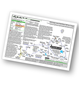
Ryburn Reservoir - River Ryburn - Higher Wormaid - Grey Stone Height - Cat Moss - Rishworth Moor - Warm Withens Hill - Rishworth Drain - Sam Hill - Green Withens Reservoir - Green Withens Moss - Dog Hill (Rishworth Moor) - Blackwood Edge - Blackwood Farm - Hutch Brook - Ryburn Reservoir
See this list of walks, routes & maps in:
Grade Order | Length Order | Time Order | Walk Number or Start Location Order
NB. To reverse (toggle) this order, click Grade Order again


