26 easy-to-follow circular walk route maps of all grades in Dartmoor
Dartmoor National Park is located in the county of Devon, South West England.
Tap/mouse over a coloured circle (1-3 easy walks, 4-6 moderate walks, 7-9 hard walks) and click to select.
You can use these checkboxes to show only the grades of walk you are interested in:-
Scroll down the list of walks below & click on each walk title (in blue) to locate it on the map above.
See this list of walks, routes & maps in:
Grade Order | Length Order | Time Order | Walk Number or Start Location Order
NB. To reverse (toggle) this order, click Grade Order again
Walk de101 Higher White Tor and Rough Tor from Two Bridges
Wild moorland walking
   |
Vital Statistics:
| Length: | 8.25 miles (13 km) |
| Ascent: | 1,027ft (313m) |
| Time: | 4 hrs |
| Grade: |  |
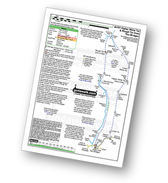
Route Summary:
Two Bridges - Parson's Cottage - Crockern Tor - Littaford Tors - Longaford Tor - Higher White Tor - Lower White Tor - Brown's House - West Dart River - Rough Tor - West Dart River - Cockern Farm - Two Bridges
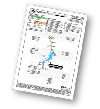
Walk de102 A circuit of Meldon Reservoir
Delightful lakeside stroll
|
Vital Statistics:
| Length: | 2.75 miles (4.5 km) |
| Ascent: | 696ft (212m) |
| Time: | 2 hrs |
| Grade: |  |
Walk de103 The Teign Gorge from Dogmarsh Bridge
Popular gorge walk - and with good reason
|
Vital Statistics:
| Length: | 5.25 miles (8.5 km) |
| Ascent: | 912ft (278m) |
| Time: | 3 hrs |
| Grade: |  |
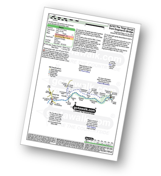
Route Summary:
Dogmarsh Bridge - The River Teign - The Teign Gorge - Sharp Tor - Fingle Bridge - Drewston Wood - Drewston Common - Hunting Gate - Piddletown Common - Castle Drogo - Hunter's Tor - Coombe - The River Teign - Dogmarsh Bridge
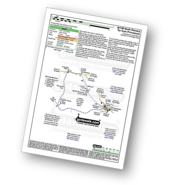
Walk de104 South Hessary Tor and Black Tor from Princetown
Easy moorland walk
|
Vital Statistics:
| Length: | 7.75 miles (12.5 km) |
| Ascent: | 643ft (196m) |
| Time: | 3½ hrs |
| Grade: | |
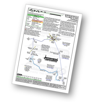
Route Summary:
Princetown - South Hessary Tor - Siward's Cross - Nun's Cross - Devonport Leat - Raddick Hill - River Meavey - Black Tor (Walkhampton Common) - The Dartmoor Way - Princetown
Walk de107 Bellever Tor, Laughter Tor and Dartmeet from Postbridge
High moorland & pretty valleys - simply fantastic
|
Vital Statistics:
| Length: | 9.75 miles (15.5 km) |
| Ascent: | 1,457ft (444m) |
| Time: | 5 hrs |
| Grade: |  |
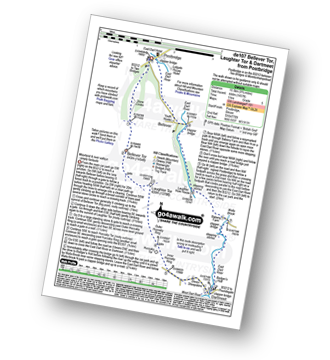
Route Summary:
Postbridge - Bellever Tor - Laughter Tor - Huccaby Tor - Dartmeet - West Dart River - East Dart River - Walla Brook - Bellever - Postbridge
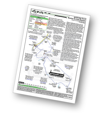
Walk de110 Great Links Tor and Kitty Tor from Sourton
High moorland walk to superb views
|
Vital Statistics:
| Length: | 9.5 miles (15.5 km) |
| Ascent: | 1,638ft (499m) |
| Time: | 5.25hrs |
| Grade: |  |
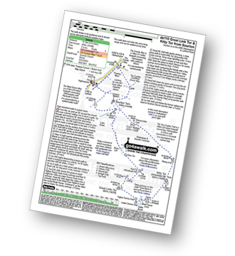
Route Summary:
Sourton - Sourton Church - River Lyd - Gren Tor - Hunt Tor - Woodcock Hill - Great Links Tor - Higher Dunna Goat - Lower Dunna Goat - Rattle Brook - Green Tor - Kitty Tor (Amicombe Hill) - Amicombe Hill - Steng-a-tor - Corn Ridge - Branscombe Loaf - Sourton Tors - Two Castles Trail - The West Devon Way - Prewley Moor - The Granite Way - Sourton Church.
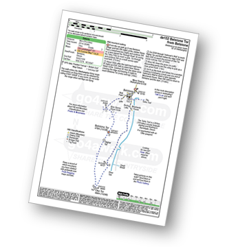
Walk de114 Belstone Cleave and The East Okement River from Belstone
Stunning river valley walk
|
Vital Statistics:
| Length: | 7 miles (11 km) |
| Ascent: | 1,185ft (361m) |
| Time: | 3.75hrs |
| Grade: | |
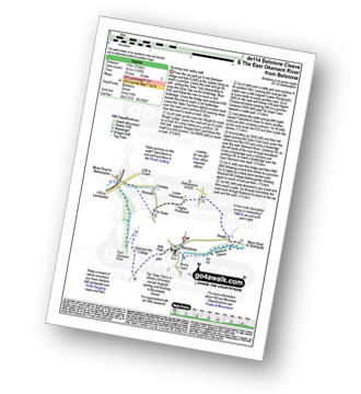
Route Summary:
Belstone - The Tarka Trail - Belstone Cleave - Skaigh - Tor Down The East Okement River - Watchett Hill Cottage - Well Park - Belstone
Walk de117 Steeperton Tor from Belstone
Wild moorland walking
|
Vital Statistics:
| Length: | 7.5 miles (12 km) |
| Ascent: | 1,141ft (348m) |
| Time: | 3½ hrs |
| Grade: | |
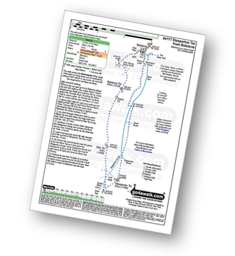
Route Summary:
Belstone - The Tarka Trail - Nine Stones Stone Circle - Belstone Tor - Higher Tor - Okehampton Army Firing Range - Oke Tor - Steeperton Tor - Steeperton Gorge - River Taw - Belstone
Walk de121 Hare Tor and Tavy Cleave from Lanehead
Wild moorland followed by a gorge
|
Vital Statistics:
| Length: | 4.5 miles (7 km) |
| Ascent: | 870ft (265m) |
| Time: | 2½ hrs |
| Grade: | |
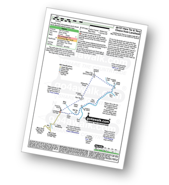
Route Summary:
Lanehead - Ger Tor - Willsworthy Army Firing Range - Hare Tor - Rattle Brook - River Tavy - Watern Oke - Tavy Cleave - Mine Leat - Nattor Farm - Lanehead
Walk de122 North Hessary Tor, Great Mis Tor and Great Staple Tor from Princetown
High Moorland walk
|
Vital Statistics:
| Length: | 11 miles (17.5 km) |
| Ascent: | 1,526ft (476m) |
| Time: | 5½ hrs |
| Grade: | |
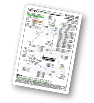
Route Summary:
Princetown - North Hessary Tor - Rundlestone - Little Mis Tor - Great Mis Tor - Merrivale Army Firing Range - Greena Ball - River Walkham - Langstone Mor Stone Circle - Petertavy Great Common - Roos Tor - Great Staple Tor - Middle Staple Tor - Grimstone and Sortridge Leat - River Walkham - Yellowmeade Farm - Foggintor Quarry - The Dartmoor Way - Princetown
Walk de123 Sourton Tors and Meldon Reservoir from Sourton
High moorland walk to superb views
|
Vital Statistics:
| Length: | 6.5 miles (10.5 km) |
| Ascent: | 1,188ft (362m) |
| Time: | 3.75hrs |
| Grade: | |
Route Summary:
Sourton - Sourton Church - Two Castles Trail - The West Devon Way - Sourton Tors - Vellake Brook - West Okement River - Vellake Weir - Meldon Reservoir - Downside - The Granite Way - Prewley Moor - Sourton Church.
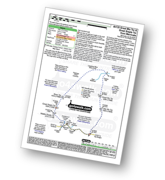
Walk de133 Laughter Tor from Dartmeet
Lovely valley and open moorland
|
Vital Statistics:
| Length: | 7.25 miles (11.5 km) |
| Ascent: | 1,247ft (380m) |
| Time: | 3.25hrs |
| Grade: | |
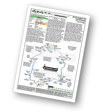
Route Summary:
Dartmeet - East Dart River - Stepping Stones - Walla Brook - Babeny Farm - East Dart River - Stepping Stones - Laughter Hole Farm - Laughter Tor - Dunnabridge Pound - West Dart River - River Swincombe - Hexworthy - Dartmeet
Walk de135 Great Mis Tor and Great Staple Tor from Merrivale
High Moorland walk
|
Vital Statistics:
| Length: | 6.25 miles (10 km) |
| Ascent: | 1,139ft (347m) |
| Time: | 3½ hrs |
| Grade: | |
Route Summary:
Merrivale - Little Mis Tor - Great Mis Tor - Merrivale Army Firing Range - Greena Ball - River Walkham - Langstone Moor Stone Circle - Petertravy Great Common - Roos Tor - Great Staple Tor - Middle Staple Tor - Grimstone and Sortridge Leat - River Walkham - Merrivale
Walk de138 Hound Tor (Bonehill Down) and Bowerman's Nose from Swallerton Gate
Lovely moorland walk to a famous feature
|
Vital Statistics:
| Length: | 6.25 miles (10 km) |
| Ascent: | 1,132ft (345m) |
| Time: | 3½ hrs |
| Grade: | |
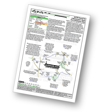
Route Summary:
Swallerton Gate - Hound Tor (Bonehill Down) - Hundaford Village - Greator Rocks - Becka Brook - Leighton Farm - Beckaford Bridge - New Bridge - Water - Hayne Cross - Hayne Down - Bowerman's Nose - Swine Down - Jay's Grave - Moorhayes Farm - Swallerton Gate
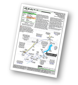
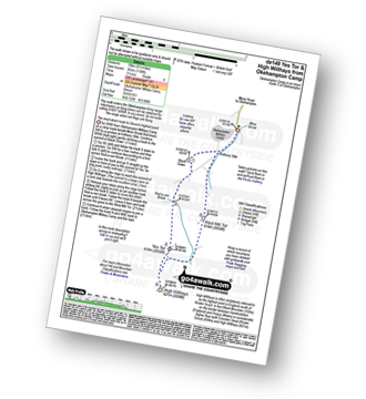
Walk de139 Yes Tor, High Willhays and Black Tor from Meldon Reservoir
Dartmoor's (& Devon's) highest point
|
Vital Statistics:
| Length: | 6.25 miles (10 km) |
| Ascent: | 1,621ft (494m) |
| Time: | 4 hrs |
| Grade: | |
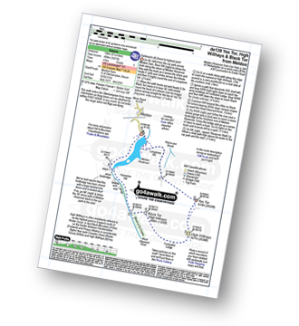
Route Summary:
Meldon Reservoir - Longstone Hill - Okehampton Army Firing Range - Yes Tor - High Willhays - Black Tor - West Okement River - Vellake Weir - Meldon Reservoir
Walk de143 Steeperton Tor and Cosdon Tor from Belstone
Wild moorland walking on two of Dartmoor's highest
|
Vital Statistics:
| Length: | 10.25 miles (16.5 km) |
| Ascent: | 1,664ft (507m) |
| Time: | 5½ hrs |
| Grade: | |
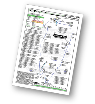
Route Summary:
Belstone - The Tarka Trail - Nine Stones Stone Circle - Belstone Tor - Irishman's Wall - Higher Tor - Okehampton Army Firing Range - Oke Tor - The River Taw - Steeperton Tor - Steeperton Brook - Wild Tor - Hound Tor - White Moor Stone Circle - Little Hound Tor - South Tawton Common - Cosdon Hill (Cawsand Hill) - Skaigh Warren - The River Taw - Belstone
Walk de144 Great Mis Tor from Merrivale
High Moorland walk
|
Vital Statistics:
| Length: | 5 miles (8 km) |
| Ascent: | 748ft (228m) |
| Time: | 2.75hrs |
| Grade: | |
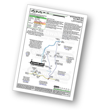
Route Summary:
Merrivale - Little Mis Tor - Great Mis Tor - Merrivale Army Firing Range - Greena Ball - River Walkham - Blowing House - Merrivale
Walk de145 Kitty Tor and Sourton Tor from Sourton
High moorland walk to superb views
|
Vital Statistics:
| Length: | 8.25 miles (13 km) |
| Ascent: | 1,375ft (419m) |
| Time: | 4½ hrs |
| Grade: | |
Route Summary:
Sourton - Sourton Church - River Lyd - Gren Tor - Hunt Tor - Woodcock Hill - Rattle Brook - Kitty Tor (Amicombe Hill) - Amicombe Hill - Sten-a-tor - Corn Ridge - Sourton Tors - Two Castles Trail - The West Devon Way - Prewley Moor - The Granite Way - Sourton Church.
Walk de146 North Hessary Tor from Princetown
Easy walk to fine views in all directions
|
Vital Statistics:
| Length: | 4.75 miles (7.5 km) |
| Ascent: | 525ft (160m) |
| Time: | 2.25hrs |
| Grade: | |
Route Summary:
Princetown - North Hessary Tor - Rundlestone - Yellowmeade Farm - Foggintor Quarry - The Dartmoor Way - Princetown
Walk de149 Yes Tor and High Willhays from Okehampton Camp
Dartmoor's (& Devon's) highest point
|
Vital Statistics:
| Length: | 6 miles (9.5 km) |
| Ascent: | 1,188ft (362m) |
| Time: | 3½ hrs |
| Grade: | |
Route Summary:
Okehampton Camp - Anthony Stile - Black Down - Red-a-ven Brook - Okehampton Army Firing Range - Yes Tor - High Willhays - West Mill Tor - Okehampton Camp
Walk de152 Belstone Tor from Belstone
Wild moorland walking
|
Vital Statistics:
| Length: | 5.75 miles (9 km) |
| Ascent: | 824ft (251m) |
| Time: | 3 hrs |
| Grade: | |
Route Summary:
Belstone - Nine Stones Stone Circle - Okehampton Army Firing Range - Belstone Tor - Higher Tor - Oke Tor - River Taw - Birchy Lake - The Tarka Trail - Belstone
Walk de166 Higher White Tor from Two Bridges
Wild moorland walking
|
Vital Statistics:
| Length: | 5 miles (8 km) |
| Ascent: | 794ft (242m) |
| Time: | 2.77hrs |
| Grade: | |
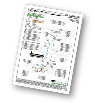
Route Summary:
Two Bridges - Parson's Cottage - Crockern Tor - Littaford Tors - Longaford Tor - Higher White Tor - Wistman's Wood - West Dart River - Two Bridges
Walk de171 Lynch Tor and Fur Tor from Lanehead
Wild moorland and a dramatic ravine
|
Vital Statistics:
| Length: | 9 miles (14.5 km) |
| Ascent: | 1,398ft (426m) |
| Time: | 4.75hrs |
| Grade: | |
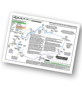
Route Summary:
Lanehead Car Park - Higher Willsworthy - Crouster Farm - Merrivale Army Firing Range - Lynch Tor - Oakhampton Army Firing Range - Fur Tor - Amicombe Brook - Watern Oke - River Tavy - Tavy Cleave - Wilsworthy Army Firing Range - Mine Leat - Nattor Farm - Lanehead Car Park.
Walk de177 Yes Tor and High Willhays from Meldon Reservoir
Dartmoor's (& Devon's) highest point
|
Vital Statistics:
| Length: | 9.5 miles (15 km) |
| Ascent: | 1,687ft (514m) |
| Time: | 5 hrs |
| Grade: | |
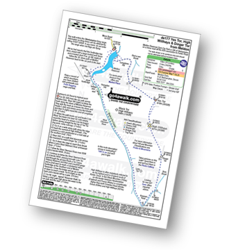
Route Summary:
Meldon Reservoir - Longstone Hill - Yes Tor - High Willhays - Dinger Tor - Brim Beck - Kneeset Nose - Sandy Ford - West Okement River - Black-a-Tor Copse - Vellake Weir - Meldon Reservoir
Walk de183 Devil's Tor from Two Bridges
Wild moorland walking
|
Vital Statistics:
| Length: | 8.25 miles (13 km) |
| Ascent: | 1,201ft (366m) |
| Time: | 4.25hrs |
| Grade: | |

Route Summary:
Two Bridges - Beardown Farm - Devonport Leat - Beardown Tors - West Dart River - Mothern Brook - Merrivale Army Firing Range - Devil's Tor - Cowsic River - Two Bridges
Walk de202 Bellever Tor and Laughter Tor from Postbridge
Fine views and an ancient clapper bridge
|
Vital Statistics:
| Length: | 5.25 miles (8.5 km) |
| Ascent: | 821ft (250m) |
| Time: | 2.75hrs |
| Grade: | |
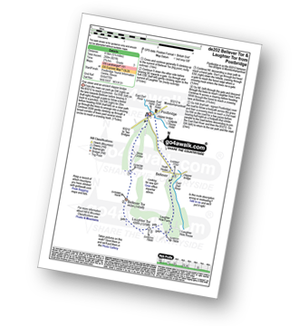
Route Summary:
Postbridge - East Dart River - Bellever Tor - Laughter Tor - Laughter Hole Farm - Bellever - Postbridge
See this list of walks, routes & maps in:
Grade Order | Length Order | Time Order | Walk Number or Start Location Order
NB. To reverse (toggle) this order, click Grade Order again