36 walks in Northumberland
Northumberland National Park is located in North East England and wholly within the county of Northumberland.
To see interactive maps and list of Mountains, Tops, Peaks and Hills to climb in the area, see Peak Bagging the Lake District.
Interactive Map of Walks in Northumberland
![]() How to Load this interactive map: Due to usage restrictions, you must be Registered and Logged-On to go4awalk.com to view and use the interactive Google Map below. You do not need to purchase any credits, but you must be Registered and Logged-On.
How to Load this interactive map: Due to usage restrictions, you must be Registered and Logged-On to go4awalk.com to view and use the interactive Google Map below. You do not need to purchase any credits, but you must be Registered and Logged-On.

You can use these checkboxes to show only the grades of walk you are interested in:-
Thirty-six easy-to-follow, circular, walk route maps in Northumberland in Walk Grade Order
See this list of walks, routes & maps in:
Grade Order | Length Order | Time Order | Walk Number or Start Location Order
NB. To reverse (toggle) this order, click Grade Order again
Scroll down the list of walks below & click on each walk title (in blue) to locate it on the map above.
   |
Vital Statistics:
| Length: | 8.25 miles (13 km) |
| Ascent: | 1,460 ft (445 m) |
| Time: | 4½ hrs |
| Grade: |  |

Route Summary:
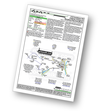
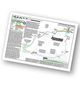
Housteads Visitor Centre - Chapel Hill - Housesteads - Vercovicium Fort - The Hadrian's Wall Path - Housesteads Crags - Cuddy's Crag - The Pennine Way - Hotbank Crags - Hotbank - Crag Lough - Highshield Crags - Steel Rigg - Peel Crags - Peel - Once Brewed - Brackies Burn - Smith's Shield - Causeway House - Vindolanda Roman Fort - Chesterholm - Barcombe - East Crindledykes Farm - Green Brae - Little Shield - Deafley Rigg - Housteads Visitor Centre
|
Vital Statistics:
| Length: | 7 miles (11 km) |
| Ascent: | 2,022 ft (616 m) |
| Time: | 4½ hrs |
| Grade: | |

Route Summary:
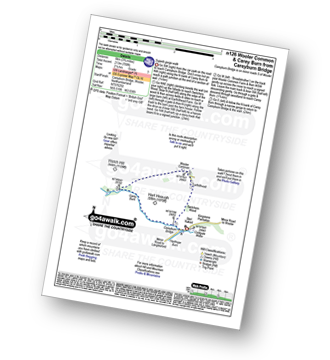
Harthope Burn Valley - Hawsen Burn Parking Area - New Burn - Scald Hill - The Cheviot - Scald Hill - New Burn - Hawsen Burn Parking Area.
|
Vital Statistics:
| Length: | 4 miles (6.75 km) |
| Ascent: | 732 ft (223 m) |
| Time: | 2½ hrs |
| Grade: |  |

Route Summary:
Harbottle Castle - Drake Stone - West Wood - Harbottle Lake - Angryhaugh - Low Winton - River Coquet - Harbottle - Harbottle Castle
|
Vital Statistics:
| Length: | 9.5 miles (15 km) |
| Ascent: | 1,378 ft (420 m) |
| Time: | 4.75 hrs |
| Grade: | |
Route Summary:
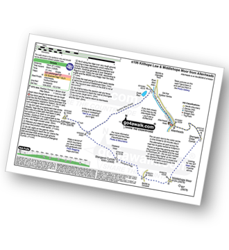
Allenheads - Dirt Pots - The Weardale Way - Killhope Law - Stangend Currick - Middlehope Moor - Shorngate Cross - Allenheads
|
Vital Statistics:
| Length: | 7.5 miles (12 km) |
| Ascent: | 1,257 ft (383 m) |
| Time: | 4½ hrs |
| Grade: | |

Route Summary:
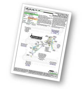
Wooler - The St Cuthbert's Way - Waud House - Kenterdale Hill - Wooler Common - Switcher Wood - Earlhillhead Farm - Carey Burn - Careyburn Bridge - Harthope Burn - Colgate Water (High Level Route) - Happy Valley - Middleton Old Town - North Middleton - Colgate Mill - Colgate Water - Earle Mill - Wooler Water - Wooler
|
Vital Statistics:
| Length: | 7.5 miles (12 km) |
| Ascent: | 1,753 ft (534 m) |
| Time: | 4½ hrs |
| Grade: | |

Route Summary:
Rowhope Burn Bridge - River Coquet - Hindside Knowe - The Street - Swineside Law - Black Braes - Windy Rigg Top - Windy Gyle - Trows Burn - Rowhope Burn - Rowhope Burn Bridge
|
Vital Statistics:
| Length: | 7.25 miles (11.5 km) |
| Ascent: | 1,165 ft (355 m) |
| Time: | 3.75 hrs |
| Grade: |  |
Route Summary:
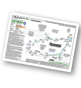
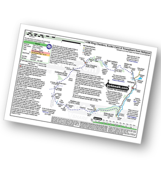
Hethpool - The St Cuthbert's Way - Elsdon Burn - Elsdonburn Farm - Shank's Sike - Scaldhill Shank - Tom's Knowe - Tuppie's Sike - Eccles Cairn - England / Scotland Border - The Pennine Way - Tuppie's Grave - The Tongue - Maddie's Well - Madam Law - Wideopen Head - Trowup Burn - Trowupburn - College Valley - College Burn - Hethpool
|
Vital Statistics:
| Length: | 10.5 miles (17 km) |
| Ascent: | 2,614 ft (797 m) |
| Time: | 6½ hrs |
| Grade: |  |

Route Summary:
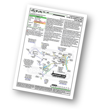
Harthope Burn Valley - Cold Law - Broadhope Hill - Scald Hill - The Cheviot - The Pennine Way - Harthope Burn - Langleeford Hope - Langleeford - Harthope Burn Valley
|
Vital Statistics:
| Length: | 4.75 miles (7.5 km) |
| Ascent: | 985 ft (300 m) |
| Time: | 2.75 hrs |
| Grade: | |
Route Summary:
Wooler - Gallowlaw Gallowlaw Hill - Humbleton - Humbleton Hill - Brown's Law - Wooler Common And Woodland Park - Wooler
|
Vital Statistics:
| Length: | 8.5 miles (13.5 km) |
| Ascent: | 2,114 ft (644 m) |
| Time: | 5½ hrs |
| Grade: |  |

Route Summary:
Harthope Burn Valley - Hawsen Burn Parking Area - New Burn - Scald Hill - The Cheviot - Cairn Hill (Scotsmans Cairn) - Harthope Burn - Hrthope Linn - Langleeford Hope - Cat Loup - Ray Burn - Langleeford Farm - Hawsen Burn Parking Area.
|
Vital Statistics:
| Length: | 8.5 miles (13.5 km) |
| Ascent: | 804 ft (245 m) |
| Time: | 4 hrs |
| Grade: | |

Route Summary:
Haltwhistle - Wydon Farm - Wydon Eals Farm - River South Tyne - Featherstone Castle - Lambley Viaduct Nature Trail - Thorneyhole Wood - Featherstone Rowfoot - Park Village - Broomhouse Farm - Haltwhistle
|
Vital Statistics:
| Length: | 3.75 miles (6 km) |
| Ascent: | 700 ft (213 m) |
| Time: | 2.25 hrs |
| Grade: | |
Route Summary:
Careyburn Bridge - Carey Burn - Switcher Wood - Earlhillhead Farm - Wooler Common - Carey Burn - Careyburn Bridge
|
Vital Statistics:
| Length: | 5.25 miles (8.5 km) |
| Ascent: | 512 ft (156 m) |
| Time: | 2½ hrs |
| Grade: | |

Route Summary:
Bamburgh - Bamburgh Castle - The Wynding - Harkess Rocks - Bamburgh Lighthouse - Blackrocks Point - Hare Law - Kittling Hill - Budle Point - Heather Cottages - Kiln Point - Budle - East Hill - Warren Camping and Caravan Park - Drawkiln Hill - Shada Plantation - Gallinheugh Bank - Bamburgh
|
Vital Statistics:
| Length: | 9.5 miles (15 km) |
| Ascent: | 2,009 ft (612 m) |
| Time: | 5½ hrs |
| Grade: | |

Route Summary:
Wedder Leap - River Coquet - Rowhope Burn - Trows Burn - Windy Gyle - The Pennine Way - Hazely Law - Hepden Burn - Clennel St - Middle Hill - Fairhaugh - Barrow Burn - Barrowburn.
|
Vital Statistics:
| Length: | 8.5 miles (13.5 km) |
| Ascent: | 1,450 ft (442 m) |
| Time: | 4.75 hrs |
| Grade: | |
Route Summary:
Rothbury - The St Oswald's Way - Whitton - Whittondean Farm - Garleigh Moor - Lordenshaws Car Park - The Beacon - Dove Crag - Old stell Crag - Simonside - Bob Pyle's Studdie - Joe's Wood - Great Tosson - The Old Pumphouse - River Coquet - Anton's Letch - Rothbury
|
Vital Statistics:
| Length: | 4.75 miles (7.5 km) |
| Ascent: | 735 ft (225 m) |
| Time: | 2½ hrs |
| Grade: | |

|
Vital Statistics:
| Length: | 9.5 miles (15.5 km) |
| Ascent: | 2,800 ft (853 m) |
| Time: | 6½ hrs |
| Grade: | |

Route Summary:
Harthope Burn Valley - Hawsen Burn Parking Area - New Burn - Scald Hill - The Cheviot - Cairn Hill (Scotsmans Cairn) - Harthope Burn - Comb Fell - Hedgehope Hill - Long Crags - Housey Crags - Hawsen Burn Parking Area.
|
Vital Statistics:
| Length: | 17 miles (27 km) |
| Ascent: | 3,463 ft (1,055 m) |
| Time: | 9½ hrs |
| Grade: |  |
Route Summary:
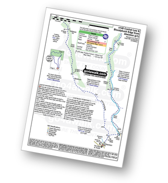
Alwinton - River Alwin - Alwindale - Kidland Forest - Yoke Burn - Cushat Law - Bloodybush Edge - Uswayford Farm - Usway Burn - Nettlehope Hill - Flesh Shank - Wholehope - Clennell Street - Howedon Burn - Alwinton
|
Vital Statistics:
| Length: | 5 miles (8 km) |
| Ascent: | 1,021 ft (311 m) |
| Time: | 3 hrs |
| Grade: | |

Route Summary:
Hethpool - The St Cuthbert's Way - White Hill (Hethpool) - East Laddie's Knowe - Laddie's Knowe or Betsy's Cairn - Black Bog (Haddon Hill) - Haddon Hill - Ring Chesters - Elsdonburn Farm - Elsdon Burn - The St Cuthbert's Way - Hethpool
|
Vital Statistics:
| Length: | 5.5 miles (9 km) |
| Ascent: | 1,138 ft (347 m) |
| Time: | 3½ hrs |
| Grade: | |
Route Summary:
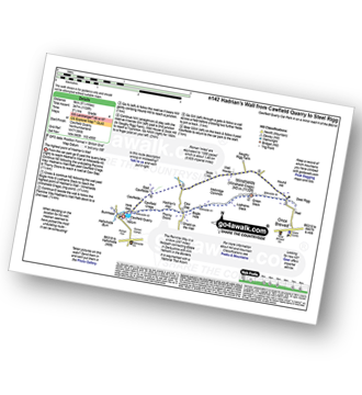
Cawfield Quarry Car Park - Hadrian's Wall - The Pennine Way - The Hadrian's Wall Path - Cawfield Crags - Thorny Doors - Caw Gap - Bogle Hole - Lodhams Slack - Winshields (Winshield Crags) - Green Slack - Steel Rigg - Hound Hill - Melkridge Common - East Cawfields - Cawfields - Cawfield Quarry Car Park
|
Vital Statistics:
| Length: | 5.75 miles (9 km) |
| Ascent: | 1,214 ft (370 m) |
| Time: | 3½ hrs |
| Grade: | |
Route Summary:
Wooler - Gallowlaw Gallowlaw Hill - Humbleton - Humbleton Hill - Brown's Law - Wooler Common and Woodland Park - The St Cuthbert's Way - Kenterdale Hill - Waud House - Wooler
|
Vital Statistics:
| Length: | 10.5 miles (16.5 km) |
| Ascent: | 2,244 ft (684 m) |
| Time: | 6 hrs |
| Grade: | |

Route Summary:
Alnham - Salter's Road - Northfieldhead - White Gate - High Knowes - Ewartly Shank - Shank Burn - Little Dod - Shill Moor - Breamish Valley - Meggrim's Knowe - Alnhammoor Farm - Rowhope Burn - Leafield Edge - Deb Cleugh - Northfieldhead - Alnham
|
Vital Statistics:
| Length: | 6.5 miles (10.5 km) |
| Ascent: | 1,043 ft (318 m) |
| Time: | 3½ hrs |
| Grade: | |

Route Summary:
Wooler - The St Cuthbert's Way - Waud House - Kenterdale Hill - Wooler Common - Switcher Wood - Earlhillhead Farm - Carey Burn - Careyburn Bridge - Harthope Burn - Colgate Water (Low Level Route) - Skirl Naked - Grimping Haugh - Broom Crook Plantation - Happy Valley - Careyburn Bridge - Colgate Mill - Earle Mill - Wooler Water - Wooler
|
Vital Statistics:
| Length: | 12.75 miles (20.5 km) |
| Ascent: | 1,759 ft (536 m) |
| Time: | 6½ hrs |
| Grade: | |

Route Summary:
Allenheads - Dirt Pots - The Weardale Way - Killhope Law - Shivery Hill - Carshield Moor - Scum Hill - Hartley Moor - Nan Davison's Cleugh - Philipson's Fold - Knockshield Moor - Black Way (Track) - Swinhope Shield - High Knock Shield - Knock Shield - Knockburn Farm - River East Allen - Low Sipton Shield - Sipton Terrace - Teedham Green - Corn Mill - Low Huntwell - Dirt Pots - Allenheads
|
Vital Statistics:
| Length: | 11.25 miles (18 km) |
| Ascent: | 2,311 ft (704 m) |
| Time: | 6½ hrs |
| Grade: | |

Route Summary:
Wedder Leap - River Coquest - Rowhope Burn - Hindside Knowe - The Street - Swineside Law - Black Braes - Windy Rigg Top - Windy Gyle - Hazely Law - Usway Burn - Middle Hill - Fairhaugh - Barrow Burn - Barrowburn.
|
Vital Statistics:
| Length: | 7.5 miles (12 km) |
| Ascent: | 1,316 ft (401 m) |
| Time: | 4 hrs |
| Grade: | |

Route Summary:
Hethpool - The St Cuthbert's Way - White Hill (Hethpool) - East Laddie's Knowe - Laddie's Knowe or Betsy's Cairn - Black Bog (Haddon Hill) - Haddon Hill - Ring Chesters - Sheepfold - Eccles Cairn - England / Scotland Border - Elsdonnurn Farm - Elsdon Burn - The St Cuthbert's Way - Hethpool
|
Vital Statistics:
| Length: | 3.25 miles (5 km) |
| Ascent: | 525 ft (160 m) |
| Time: | 1.75 hrs |
| Grade: |  |
Route Summary:
Wooler - The St Cuthbert's Way - Waud House - Kenterdale Hill - Wooler Common and Woodland Park - Wooler
|
Vital Statistics:
| Length: | 16.5 miles (26.5 km) |
| Ascent: | 3,144 ft (958 m) |
| Time: | 9.25 hrs |
| Grade: | |

Route Summary:
Hethpool - College Valley - Whitehall - Fleehope - Mounthooly - Birnie Brae - The Pennine Way - Red Cribs - Auchope Cairn - Cairn Hill - The Cheviot - Scald Hill - Goldcleugh - Lambden Burn - Dunsdale - Coldburn - Southernknowe - Whitehall - Hethpool
|
Vital Statistics:
| Length: | 10.25 miles (16.5 km) |
| Ascent: | 1,182 ft (360 m) |
| Time: | 5 hrs |
| Grade: | |

Route Summary:
Wooler - The St Cuthbert's Way - Weetwood Bank - Weetwood Moor - River Till - Weetwood Bridge - Weetwood Hall - Weetwood Hill - Broomy Knowe - Shepherds House - Dod Law (Doddington Moor) - Doddington Moor - Doddington - River Till - St Cuthbert's Bridge - Milfield Plain - River Glen - Bridge End - Bowchester - Low Humbleton - Gallowlaw Hill - Gallowlaw - Wooler
|
Vital Statistics:
| Length: | 13.5 miles (21.5 km) |
| Ascent: | 2,504 ft (763 m) |
| Time: | 7½ hrs |
| Grade: | |

Route Summary:
Alwinton - Hosedon Burn - The Creel - Clennelstreet Farm - Clennell Street (Track) - Cross Dyke - Uplaw Knowe - Hare Sheds - Wholehope - Wholehope Knowe - Saughy Hill - Nettlehope Hill - Usway Burn - The Middle - Middle Hill - Fairhaugh - Hoseden Law - The Castles - Batailshiel Haugh - Shillmoor - The Knocks - Pass Peth - Alwinton
|
Vital Statistics:
| Length: | 8.5 miles (13.5 km) |
| Ascent: | 988 ft (301 m) |
| Time: | 4.25 hrs |
| Grade: | |

Route Summary:
Eglingham - Tarry - Eglingham Moor - Curleheugh - Hare Crag - Ceteran Hill - Ceteran Meadows Moss - Blawearie - Bewick Moor - Tick Law - Harehope Hill - Harehope Farm - Ticket Hill - Eglingham
|
Vital Statistics:
| Length: | 8.5 miles (13.5 km) |
| Ascent: | 945 ft (288 m) |
| Time: | 4 hrs |
| Grade: | |

Route Summary:
Hawkhope Car Park - Starsley Burn - Falstone Mine - Flastone Forest - Belling Burn - Goodwell Syke - Soney Gap - Plashetts Incline Jetty - Kielder Water - Benny Shanks Jetty - Pot Burn - Cock Soor - Whinny Hill - Belling Burn - The Belling - Bastle - Kielder Water Dam - Hawkhope Car Park
|
Vital Statistics:
| Length: | 8.25 miles (13 km) |
| Ascent: | 1,483 ft (452 m) |
| Time: | 4½ hrs |
| Grade: | |
Route Summary:
Hethpool - The St Cuthbert's Way - White Hill (Hethpool) - East Laddie's Knowe - Laddie's Knowe or Betsy's Cairn - Black Bog (Haddon Hill) - Haddon Hill - Ring Chesters - Sheepfold - Eccles Cairn - England / Scotland Border - The Pennine Way - Tuppie's Grave - The Tongue - Maddie's Well - Madam Law - Wideopen Head - Trowup Burn - Trowupburn - College Valley - College Burn - Hethpool
|
Vital Statistics:
| Length: | 13.75 miles (22 km) |
| Ascent: | 2,665 ft (812 m) |
| Time: | 7.75 hrs |
| Grade: | |

Route Summary:
Hethpool - The St Cuthbert's Way - Elsdon Burn - Elsdonburn Farm - Shank's Sike - Scaldhill Shank - Tom's Knowe - Tuppie's Sike - Eccles Cairn - England / Scotland Border - The Pennine Way - White Law - Steel Rig - Black Hag (Hethpool) - The Schil - Birnie Brae - Red Cribs - Mounthooly - Fleehope - Whitehall - College Valley - Hethpool
|
Vital Statistics:
| Length: | 10.75 miles (17 km) |
| Ascent: | 1,746 ft (532 m) |
| Time: | 5.75 hrs |
| Grade: | |

Route Summary:
Wooler - The St Cuthbert's Way - Waud House - Kenterdale Hill - Wooler Common - Carey Burn - Broadstruthers Burn - Commonburn House - Wackerage Cairn - Tom Tallon's Crag - The St Cuthbert's Way - Gleadscleugh - Akeld Burn - Humbleton - Gallowlaw - Wooler
|
Vital Statistics:
| Length: | 4.5 miles (7 km) |
| Ascent: | 781 ft (238 m) |
| Time: | 2½ hrs |
| Grade: | |

Route Summary:
Careyburn Bridge - Carey Burn - Harthope Burn - Middleton Old Town - North Middleton - Colgate Mill - Colgate Water (Low Level Route) - Happy Valley - Broom Crook Plantation - Grimping Haugh - Skirl Naked - Careyburn Bridge
See this list of walks, routes & maps in:
Grade Order | Length Order | Time Order | Walk Number or Start Location Order
NB. To reverse (toggle) this order, click Grade Order again


