UK Postcode TA7 - The 30 nearest easy-to-follow, circular walk route maps to you
The thirty nearest easy-to-follow, circular walk route maps to you in UK Postcode TA7 in Walk Grade Order
The UK cities, towns and villages in Somerset, England that have TA7 in their UK Postcode include:
• Ashcott • Athelney • Bawdrip • Burrow Bridge • Burtle • Catcott • Chedzoy • Chilton Polden • Cossington • Edington • Greinton • Greylake • Hedging • Huntworth • Knowle Hall • Middlezoy • Moorlinch • North Newton • Northmoor Green or Moorland • Nythe • Othery • Pathe • Pedwell • Puriton • River Bridge • Shapwick • Stathe • Stawell • Sutton Mallet • Thorngrove • Westham • Westonzoyland • Woolavington •
Not familiar with the area around TA7?
See these 30 nearest walks to UK Postcode TA7 on a google map
   |
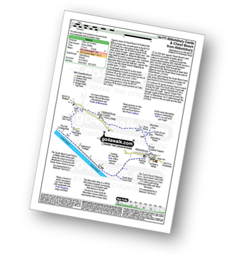
Vital Statistics:
| Length: | 7.5 miles (12 km) |
| Ascent: | 656ft (200m) |
| Time: | 3.25hrs |
| Grade: |  |
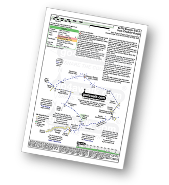
Route Summary:
Cheddar Gorge - Black Rock Nature Reserve - Long Wood Nature Reserve - Tyning's Farm - Beacon Batch (Mendip Hills) - Charterhouse - Velvet Bottom Nature Reserve - Black Rock Nature Reserve - Cheddar Gorge
|
Vital Statistics:
| Length: | 7.75 miles (12.5 km) |
| Ascent: | 1,264ft (385m) |
| Time: | 4.25hrs |
| Grade: |  |
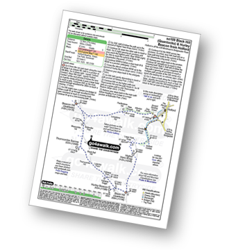
Route Summary:
Holford - Holford Combe - Lower Hare Knap - Higher Hare Knap - Black Hill (Quantocks) - Hurley Beacon - Halsway Soggs - Halsway Post - Thorncombe Hill - Black Ball Hill - Thorncombe Barrow - Weacombe Hill - Bicknoller Post - Beacon Hill (Quantocks) - Longstone Hill - Alfoxton Park - Holford
|
Vital Statistics:
| Length: | 5.75 miles (9.5 km) |
| Ascent: | 600ft (183m) |
| Time: | 2.75hrs |
| Grade: | |
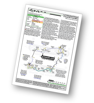
Route Summary:
Mells - Wadbury Hill Fort - Mells Stream - Wadbury Valley - Great Elm - The Macmillan Way - Buckland Brook - Buckland Dinham - Clareham Lane - Hill House Farm - Conduit Bridge - Mells
|
Vital Statistics:
| Length: | 5 miles (8 km) |
| Ascent: | 558ft (170m) |
| Time: | 2½ hrs |
| Grade: | |
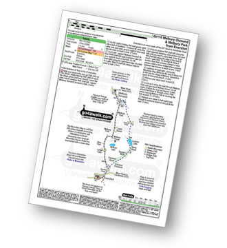
Route Summary:
Evershot - Paradise Wood - Evershot Plantation - Banger's Moor - Sares Wood - Lucerne Lake - Melbury Park - The Macmillan Way - Melbury Osmond - Lower Barton - Melbury House - Evershot
|
Vital Statistics:
| Length: | 5.5 miles (8.5 km) |
| Ascent: | 722ft (220m) |
| Time: | 2.75hrs |
| Grade: | |
Route Summary:
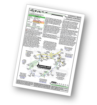
Easton-in-Gordano - The Gordano Round - Hails Wood - The Bottoms - Summer House Wood - Windmill Hill - Buddings Wood - Downs School - Charlton Farm Children's Hospice - Prior's Wood - Portbury - Portbury Standing Stone - Gordano Services - Easton-in-Gordano
|
Vital Statistics:
| Length: | 5.75 miles (9 km) |
| Ascent: | 1,083ft (330m) |
| Time: | 3.25hrs |
| Grade: |  |
Route Summary:
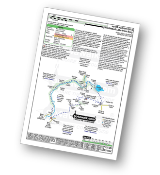
Bury - River Haddeo - Hartford Bottom - Hartford Lodge - Pulham River - Upton Dam - Wimbleball Lake - Haddon Hill - Hadborough (Haddon Hill) - Hadborough Plantation - Haddon Farm - Bury
|
Vital Statistics:
| Length: | 9.5 miles (15 km) |
| Ascent: | 2,038ft (621m) |
| Time: | 5½ hrs |
| Grade: |  |
Route Summary:
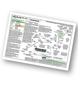
Luccombe - Luccombe Plantation - Webbers Post - Dicky's Path - Hollow Combe - Dunkery Beacon - Little Rowbarrow - Great Rowbarrow - Lang Combe Head - Cloutsham Gate - Stoke Pero Church - Prickslade - Cloutsham Farm - East Water Valley - Webbers Post - Horner Plantataion - Luccombe
|
Vital Statistics:
| Length: | 6.75 miles (11 km) |
| Ascent: | 1,254ft (382m) |
| Time: | 3.75hrs |
| Grade: | |
Route Summary:
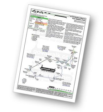
Webbers Post - Dicky's Path - Hollow Combe - Dunkery Beacon - Little Rowbarrow - Great Rowbarrow - Lang Combe Head - Cloutsham Gate - Cloutsham Farm - East Water Valley - Webbers Post
|
Vital Statistics:
| Length: | 5.5 miles (9 km) |
| Ascent: | 630ft (192m) |
| Time: | 2.75hrs |
| Grade: | |
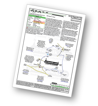
Route Summary:
Askerswell - South Eggardon Farm - North Eggardon Farm - Eggardon Hill Fort - Eggardon Hill - Haydon Down - Stancombe Farm - Askerswell Down - Nallers Farm - Askerswell
|
Vital Statistics:
| Length: | 6 miles (9.5 km) |
| Ascent: | 1,408ft (429m) |
| Time: | 3½ hrs |
| Grade: | |
Route Summary:
Bossington - Allerford - Selworthy - Selworthy Beacon - The South West Coast Path - Hurlstone Combe - Hurlstone Point - Porlock Bay - Bossington
|
Vital Statistics:
| Length: | 8.75 miles (14 km) |
| Ascent: | 1,634ft (498m) |
| Time: | 4.75hrs |
| Grade: | |
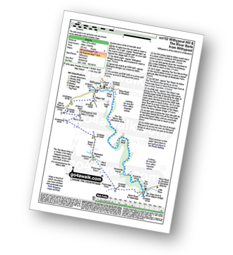
Route Summary:
Withypool - The Two Moors Way - Withypool Hill - Westwater Farm - Parsonage Down - River Barle - Tarr Steps - Knaplock Wood - Withypool
|
Vital Statistics:
| Length: | 4.75 miles (7.5 km) |
| Ascent: | 811ft (247m) |
| Time: | 2½ hrs |
| Grade: | |
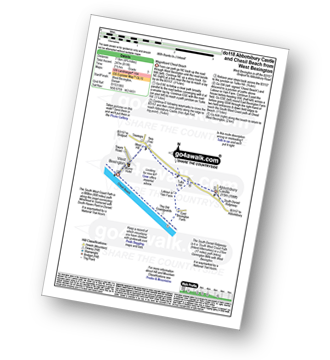
Route Summary:
West Bexington - Tulks Hill - Abbotsbury Castle (Iron Age Fort) - The South West Coast Path - Chesil Beach - West Bexington
|
Vital Statistics:
| Length: | 7 miles (11 km) |
| Ascent: | 1,037ft (316m) |
| Time: | 3½ hrs |
| Grade: | |
Route Summary:
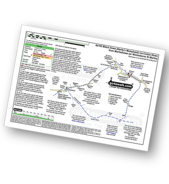
Martinstown (or Winterborne St Martin) - Grove Hill Bottom - Great Hill - South Dorset Ridgeway - Corton Down - Bronkham Hill - Jubilee Trail - Blackdown - Smitten Corner - Black Down (Hardy Monument) - Bronkham Hill - Pen Barn Farm - Grove Hill Bottom - Martinstown (or Winterborne St Martin)
|
Vital Statistics:
| Length: | 7.25 miles (11.5 km) |
| Ascent: | 847ft (258m) |
| Time: | 3½ hrs |
| Grade: | |
Route Summary:
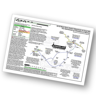
Martinstown (or Winterborne St Martin) - Four Barrows Farm - Great Hill - South Dorset Ridgeway - Corton Down - Bronkham Hill - Jubilee Trail - Blackdown - Smitten Corner - Black Down (Hardy Monument) - East Rew Farm - Rew Manor - Martinstown (or Winterboune St Martin).
|
Vital Statistics:
| Length: | 8.25 miles (13 km) |
| Ascent: | 1,070ft (326m) |
| Time: | 4 hrs |
| Grade: | |
Route Summary:
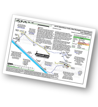
Abbotsbury - The Macmillan Way - Abbotsbury Plain - The South Dorset Ridgeway - Abbotsbury Castle (Iron Age Fort) - Tulks Hill - West Bexington - The South West Coast Path - Chesil Beach - Abbotsbury
Not familiar with the area around TA7?
See these 30 nearest walks to UK Postcode TA7 on a google map
|
Vital Statistics:
| Length: | 7.25 miles (11.5 km) |
| Ascent: | 1,158ft (353m) |
| Time: | 3.75hrs |
| Grade: | |
Route Summary:
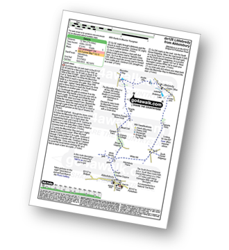
Abbotsbury - The Macmillan Way - Abbotsbury Plains - Borad Coppice - Gorwell Farm - Kingstone Russel Stone Circle - Tenants Hill - Littlebredy - Topparts Dairy - The South Dorset Ridgeway - White Hill (Abbotsbury) - Abbotsbury
|
Vital Statistics:
| Length: | 6.25 miles (10 km) |
| Ascent: | 994ft (303m) |
| Time: | 3.25hrs |
| Grade: | |
Route Summary:
Abbotsbury - The Macmillan Way - Abbotsbury Plain - The South Dorset Ridgeway - Abbotsbury Castle (Iron Age Fort) - Tulks Hill - Labour in Vain Farm - East Bexington Farm - The South West Coast Path - Chesil Beach - Abbotsbury
|
Vital Statistics:
| Length: | 4.75 miles (7.5 km) |
| Ascent: | 499ft (152m) |
| Time: | 2.25hrs |
| Grade: |  |
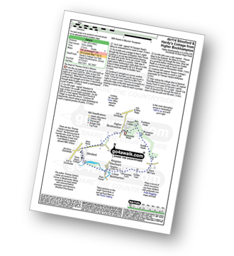
Route Summary:
Higher Bockhampton - Stinsford - Lower Bockhampton - Kingston Maurward - Duddle Heath - Bhompston Heath - Puddleton Heath - Hardy's Cottage (Thomas Hardy's Birthplace) - Thorncombe Wood - Higher Bockhampton
|
Vital Statistics:
| Length: | 5 miles (8 km) |
| Ascent: | 561ft (171m) |
| Time: | 2½ hrs |
| Grade: | |
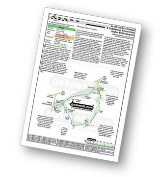
Route Summary:
Higher Bockhampton - Thorncombe Wood - Hardy's Cottage (Thomas Hardy's Birthplace) - Bhompston Heath - Duddle Heath - Castle Hill - Beacon Corner - Beacon Hill - Puddletown Forest - Hardy's Cottage (Thomas Hardy's Birthplace) - Higher Bockhampton
|
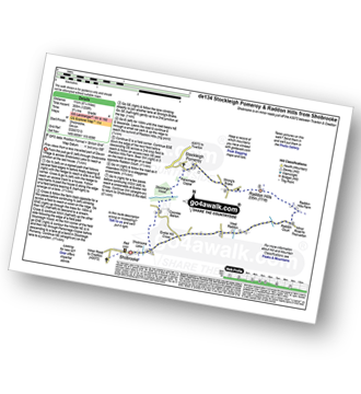
Vital Statistics:
| Length: | 7.25 miles (11.5 km) |
| Ascent: | 643ft (196m) |
| Time: | 3.25hrs |
| Grade: | |
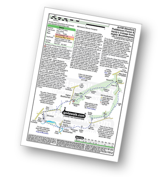
Route Summary:
Higher Bockhampton - Stinsford - Lower Bockhampton - Kingston Maurward - River Frome - Duddle Heath - Castle Hill - Beacon Corner - Beacon Hill - Puddletown Forest - Hardy's Cottage (Thomas Hardy's Birthplace) - Higher Bockhampton
|
Vital Statistics:
| Length: | 5.25 miles (8.5 km) |
| Ascent: | 322ft (98m) |
| Time: | 2.25hrs |
| Grade: | |
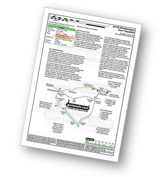
Route Summary:
Tolpuddle - Southover Heath - Clyff Copse - Tincleton Hang - Cowpound Wood - Athelhamton - Park Farm - Tolpuddle
|
Vital Statistics:
| Length: | 6.75 miles (11 km) |
| Ascent: | 1,208ft (368m) |
| Time: | 3.75hrs |
| Grade: | |
Route Summary:
Shobrooke - Shobrook Lake - Coombe Barton - Stockleigh Wood - Parsonage Copse - Stockleigh Pomeroy - Stong's Brake - Raddon Hills - Raddon Court - West Raddon - Exeter Hill Cross - Shobrooke
|
Vital Statistics:
| Length: | 5 miles (8 km) |
| Ascent: | 1,708ft (521m) |
| Time: | 3.75hrs |
| Grade: | |
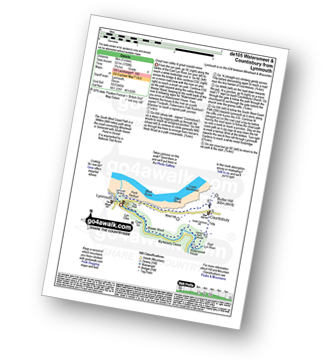
Route Summary:
Lynmouth - The East Lyn River - Wester Wood - Horner's Neck Wood - Watersmeet - Watersmeet House - Trilly - Countisbury - Butter Hill - The Sought West Coast Path - Lower Blackhead - Sillery Sands - Black Rocks - Point Perilous - Lynmouth
|
Vital Statistics:
| Length: | 5.5 miles (8.5 km) |
| Ascent: | 1,493ft (455m) |
| Time: | 3½ hrs |
| Grade: | |
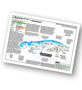
Route Summary:
Lynton - The Danes Or Valley Of Rocks - Six Acre Wood - The South West Coast Path - Lee Bay - Lee Abbey - Castle Rock - Rugged Jack - Wringcliff Bay - Ruddy Ball - Lynmouth - Lynton
|
Vital Statistics:
| Length: | 5.5 miles (9 km) |
| Ascent: | 768ft (234m) |
| Time: | 3 hrs |
| Grade: | |
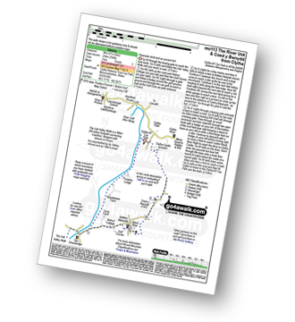
Route Summary:
Clytha National Trust Car Park - The River Usk - Afon Wysg - The Usk Valley Walk - Bettws Newydd - Coed y Bwnydd (fort) - Clytha Hill - Great House Farm - Hillgrove Farm - Clytha - Clytha National Trust Car Park
|
Vital Statistics:
| Length: | 10.5 miles (17 km) |
| Ascent: | 374ft (114m) |
| Time: | 4.25hrs |
| Grade: | |
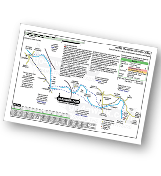
Route Summary:
Clytha National Trust Car Park - The River Usk - The Usk Valley Walk - Pant-y-Goitre - Llangatwg Dyffryn Wysg - Llanellen - Llanover - Pant-y-Goitre - Clytha National Trust Car Park
|
Vital Statistics:
| Length: | 5.25 miles (8.5 km) |
| Ascent: | 1,234ft (376m) |
| Time: | 3.25hrs |
| Grade: | |
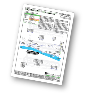
Route Summary:
Durdle Door Car Park - Daggers Gate - The Warren - Chaldon Down - The South West Coast Path - West Bottom - Middle Bottom - Bat's Hole - Bat's Head - The Jurassic Coast - Swyre Head - Scratchy Bottom - Durdle Door - Durdle Door Car Park
|
Vital Statistics:
| Length: | 9 miles (14.5 km) |
| Ascent: | 1,191ft (363m) |
| Time: | 4½ hrs |
| Grade: | |
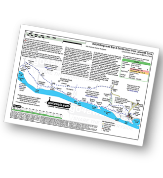
Route Summary:
Lulworth Cove - West Lulworth - Durdle Door Caravan Park - Newlands Farm - Daggers Gate - The Warren - Chaldon Down - Ringstead Bay - The Jurassic Coast - The South West Coast Path - White Nothe - Whitenothe Cottage - West Bottom - Middle Bottom - Bats Hole - Bats Head - Swyre Head - Scratchy Bottom - Durdle Door - St Oswald's Bay - Hambury Tout - Dungy Head - Stair Hole - Lulworth Cove
|
Vital Statistics:
| Length: | 4.75 miles (7.5 km) |
| Ascent: | 1,405ft (428m) |
| Time: | 3.25hrs |
| Grade: | |
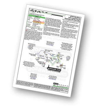
Route Summary:
Uley - Uley Bury Hill Fort - Cliff Wood - Crawley Barns - The Cotswolds Way - Hodgecombe Farm - Cam Long Down - Peaked Down - Uleyfield - Downham Hill (Smallpox Hill) - Hydegate - Uley Bury Hill Fort - Uley
|
Vital Statistics:
| Length: | 2.25 miles (3.5 km) |
| Ascent: | 164ft (50m) |
| Time: | 1 hrs |
| Grade: |  |
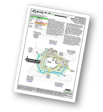
Route Summary:
Salisbury - Poultry Cross - High Street Gate - Choristers Square - Salisbury Cathedral - The River Avon - Churchill Gardens - St Martin's Church - Salisbury
Not familiar with the area around TA7?
See these 30 nearest walks to UK Postcode TA7 on a google map


