
![]()
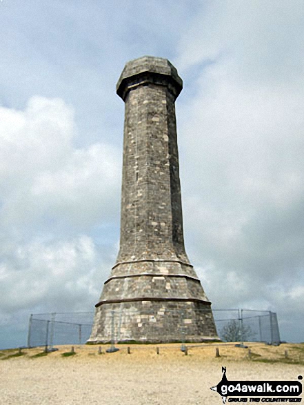
Black Down (Hardy Monument)
239m (784ft)
The Dorset Downs, Dorset, England
The summit of Black Down (Hardy Monument) is marked by an Ordnance Survey Trig Point & a tall tower.
Not familiar with this top?
   |
|---|
Vital Statistics:
| Length: | 7ml (11km) |
|---|---|
| Ascent: | 1,037ft (316m) |
| Time: | 3½ hrs |
| Grade: |  (Moderate) (Moderate) |
Route Summary:
Martinstown (or Winterborne St Martin) - Grove Hill Bottom - Great Hill - South Dorset Ridgeway - Corton Down - Bronkham Hill - Jubilee Trail - Blackdown - Smitten Corner - Black Down (Hardy Monument) - Bronkham Hill - Pen Barn Farm - Grove Hill Bottom - Martinstown (or Winterborne St Martin)
|
|---|
Vital Statistics:
| Length: | 7.25ml (11.5km) |
|---|---|
| Ascent: | 847ft (258m) |
| Time: | 3½ hrs |
| Grade: | (Moderate) |
Route Summary:
Martinstown (or Winterborne St Martin) - Four Barrows Farm - Great Hill - South Dorset Ridgeway - Corton Down - Bronkham Hill - Jubilee Trail - Blackdown - Smitten Corner - Black Down (Hardy Monument) - East Rew Farm - Rew Manor - Martinstown (or Winterboune St Martin).
A go4awalk.com downloadable Peak Bagging Map in PDF format featuring Black Down (Hardy Monument) should be available soon.
Free-to-access Interactive Walk Planning Maps:
 Fellow go4awalkers who have already walked, climbed, summited & bagged Black Down (Hardy Monument)
To add (or remove) your name and experiences on this page - Log On and edit your Personal Mountain Bagging Record
Send us your photographs and pictures on, of, or from Black Down (Hardy Monument)
If you would like to add your walk photographs and pictures featuring views from, on or of Black Down (Hardy Monument) to this page, please send them as email attachments (configured for any computer) along with your name to:
and we shall do our best to publish them.
(Guide Resolution = 300dpi. At least = 660pixels (wide) x 440 pixels (high).)

You can also submit photos via our Facebook Page.
NB. Please indicate where each photo was taken and whether you wish us to credit your photos with a Username or your First Name/Last Name.
Not familiar with this top?


