UK Postcode SK17 - The 30 nearest easy-to-follow, circular walk route maps to you
The thirty nearest easy-to-follow, circular walk route maps to you in UK Postcode SK17 in Walk Grade Order
The UK cities, towns and villages in Derbyshire, England that have SK17 in their UK Postcode include:
• Biggin • Blackwell • Brund • Burbage • Buxton • Chelmorton • Coplow Dale • Crowdecote • Dove Holes • Earl Sterndale • Ecton • Fairfield • Fawfieldhead • Flagg • Flash • Gradbach • Great Hucklow • Grindlow • Harpur Hill • Hartington • Heathcote • Hollinsclough • Hulme End • King Sterndale • Little Hucklow • Litton • Longnor • Miller's Dale • Newtown • Peak Dale • Peak Forest • Pilsbury • Sheen • Sparrowpit • Taddington • Tideswell • Upper Elkstone • Upper End • Wardlow • Warslow • Wheston • Wormhill •
Not familiar with the area around SK17?
See these 30 nearest walks to UK Postcode SK17 on a google map
   |
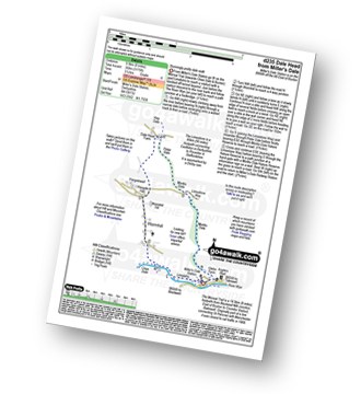
Vital Statistics:
| Length: | 5.25 miles (8.5 km) |
| Ascent: | 939ft (286m) |
| Time: | 3 hrs |
| Grade: |  |
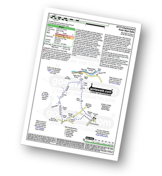
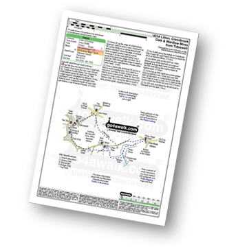
Route Summary:
Wye Dale - Topley Pike Quarry - Deep Dale - Horseshoe Dale - Bullhay Dale - Chelmorton - The Midshires Way - Marl Dale - Wye Dale
|
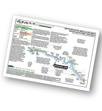
Vital Statistics:
| Length: | 8.5 miles (13.5 km) |
| Ascent: | 1,812ft (555m) |
| Time: | 5 hrs |
| Grade: |  |
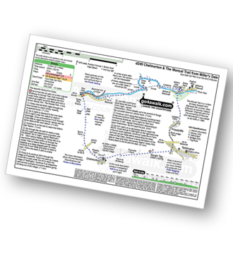
Route Summary:
Wye Dale - Blackwell Junction - The Monsal Trail - Chee Dale - Miller's Dale Station - Miller's Dale - Priestcliffe - Taddington - Sough Top - Chelmorton - The Midshires Way - Burrs Farm - Marl Dale - Topley Pike Quarry - Wye Dale
|
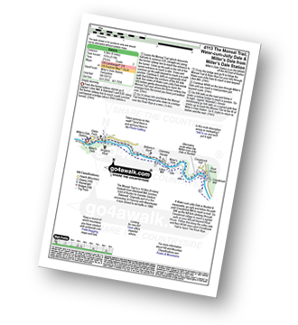
Vital Statistics:
| Length: | 15.25 miles (24.5 km) |
| Ascent: | 1,759ft (536m) |
| Time: | 7.25hrs |
| Grade: |  |
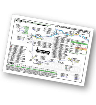
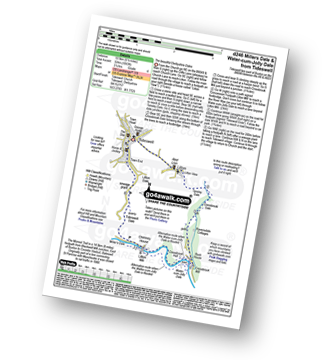
Route Summary:
Wye Dale - The River Wye - Blackwell Junction - The Monsal Trail - Chee Dale - Miller's Dale Station - Miller's Dale - Litton Mill - Water-cum-Jolly Dale - Cressbrook - Monsal Dale - White Lodge - Deep Dale - Taddington - Sough Top - Chelmorton - Burrs Farm - Marl Dale - Wye Dale
|
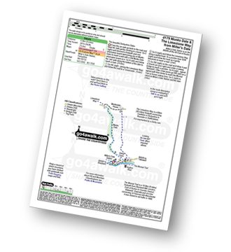
Vital Statistics:
| Length: | 4.75 miles (7.5 km) |
| Ascent: | 689ft (210m) |
| Time: | 2½ hrs |
| Grade: | |
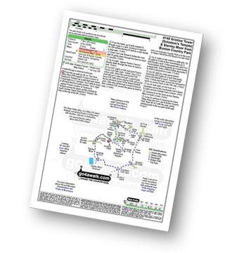
Route Summary:
Buxton and Poole's Cavern Country Park - The Dane Valley Way - Grinlow Tower - Solomon's Temple - Grin Plantation - Poole's Cavern - Fern House - Countess Cliff Farm - Stanley Moor - Stanley Moor Reservoir - Buxton and Poole's Cavern Country Park
|
Vital Statistics:
| Length: | 10.5 miles (16.5 km) |
| Ascent: | 1,287ft (392m) |
| Time: | 5 hrs |
| Grade: | |
Route Summary:
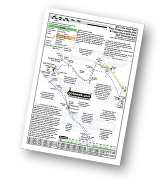
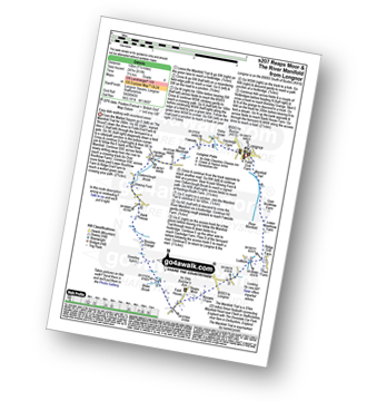
Earl Sterndale - Hindlow Quarry - Dowlow Works - The Midshires Way - The High Peak Trail - Pomeroy - Hurdlow - Parsley Hay - Darley Farm - Vincent House - Pilsbury - Pilsbury Castle Hills - Upper Dove Dale - Bridge End Farm - Crowdecote - Meadow Farm - Underhill Farm - Hitter Hill - Earl Sterndale
|
Vital Statistics:
| Length: | 7.25 miles (11.5 km) |
| Ascent: | 1,657ft (505m) |
| Time: | 4.25hrs |
| Grade: | |
Route Summary:
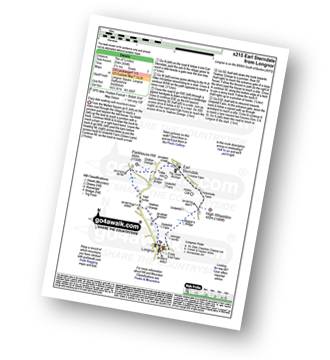
Earl Sterndale - Glutton Grange - Hatch-a-way - Dowel Dale - Owl Hole - Greensides Farm - Stoop Farm - Booth Farm - Leycote Farm - Packhorse Bridge - Moorside Farm - Hollinsclough - Swallow Brook - Parkhouse Hill - Hitter Hill - Earl Sterndale
|
Vital Statistics:
| Length: | 6.5 miles (10.5 km) |
| Ascent: | 1,283ft (391m) |
| Time: | 3.75hrs |
| Grade: |  |
Route Summary:
Buxton (Burbage Church) - Burbage Edge Plantation - Burbage Edge - Berry Clough - Goyt's Clough - Goyt's Moss - Goytsclough Quarry - The Goyt Valley - Wild Moor - Wildmoorstone Brook - Watford Moor - Beet Wood - Buxton (Burbage Church)
|
Vital Statistics:
| Length: | 9.75 miles (15.5 km) |
| Ascent: | 1,431ft (436m) |
| Time: | 5 hrs |
| Grade: | |
Route Summary:
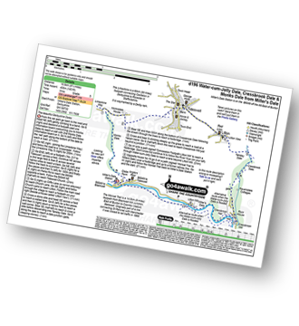
Miller's Dale Station - Monks Dale - The Limestone Way - Tideswell - Litton - Tansley Dale - Cressbrook Dale - Cressbrook - The Monsal Trail - Water-cum-Jolly Dale - Litton Mill - Miller's Dale - Miller's Dale Station
|
Vital Statistics:
| Length: | 6 miles (9.5 km) |
| Ascent: | 1,175ft (358m) |
| Time: | 3½ hrs |
| Grade: | |
Route Summary:
Miller's Dale Station - The Monsal Trail - River Wye - Wormhill - Dale Head - Peter Dale - Monk's Dale - Miller's Dale - Miller's Dale Station
|
Vital Statistics:
| Length: | 7.75 miles (12.5 km) |
| Ascent: | 840ft (256m) |
| Time: | 3.75hrs |
| Grade: | |
Route Summary:
Miller's Dale Station - The Monsal Trail - The River Wye - Miller's Dale - Water-cum-Jolly Dale - Monsal Head Viaduct - Monsal Head - Upperdale - Cressbrook Mill - The River Wye - Water-cum-Jolly Dale - Litton Mill - Bellamy's Bank - Miller's Dale Station
|
Vital Statistics:
| Length: | 6 miles (9.5 km) |
| Ascent: | 515ft (157m) |
| Time: | 2.75hrs |
| Grade: | |
Route Summary:
Miller's Dale Station - The Monsal Trail - The River Wye - Miller's Dale - Water-cum-Jolly Dale - Cressbrook Mill - The River Wye - Water-cum-Jolly Dale - Litton Mill - Bellamy's Bank - Miller's Dale Station
|
Vital Statistics:
| Length: | 4 miles (6.5 km) |
| Ascent: | 942ft (287m) |
| Time: | 2½ hrs |
| Grade: | |
Route Summary:
Miller's Dale Station - Monks Dale - The Limestone Way - Monksdale House - The River Wye - Millers Dale - The Monsal Trail - Miller's Dale Station
|
Vital Statistics:
| Length: | 7 miles (11 km) |
| Ascent: | 1,395ft (425m) |
| Time: | 4 hrs |
| Grade: | |
Route Summary:
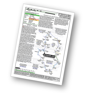
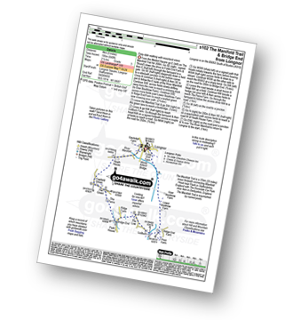
Hollinsclough - The New Farm - The Manifold Trail - Hardings Booth - Shining Ford - Holly Grove Farm - Oakenclough Brook - Oakenclough Hall Farm - Blackstone Edge - Bradshaw Farm - High Ash Farm - The River Manifold - Heathylee House - Hollinsclough Moor - Wilshaw Bottom - Wilshaw Farm - Moorside Farm - Hollinsclough
|
Vital Statistics:
| Length: | 7.5 miles (12 km) |
| Ascent: | 880ft (268m) |
| Time: | 3.75hrs |
| Grade: | |
Route Summary:
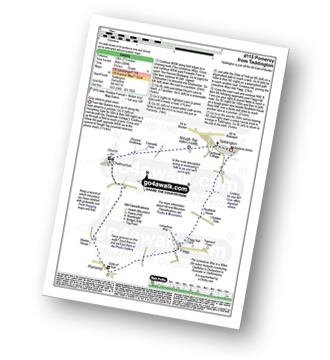
Taddington - Humphrey Gate - Slough Top - Chelmorton - The Midshires Way - Pomeroy - Flagg - Taddington.
|
Vital Statistics:
| Length: | 4.5 miles (7 km) |
| Ascent: | 538ft (164m) |
| Time: | 2.25hrs |
| Grade: |  |
Route Summary:
Longnor - The Manifold Trail - Moss Carr Farm - Hollinsclough - Swallow Brook - Yewtree Grange - Under The Hill - Longnor
Not familiar with the area around SK17?
See these 30 nearest walks to UK Postcode SK17 on a google map
|
Vital Statistics:
| Length: | 11.5 miles (18.5 km) |
| Ascent: | 1,487ft (453m) |
| Time: | 2.75hrs |
| Grade: |  |
Route Summary:
Longnor - The Manifold Trail - Gauledge Farm - Fawside Farm - The River Manifold - Hardings Booth - Shining Ford - Holly Grove Farm - Newtown - Lady Edge - Round Knowl - Noon Sun Farm - Blake Mere (Merryton Low) - Blake Brook - Lower Fleetgreen Farm - Little Fernyford Farm - The Manifold Trail - Brund Mill - Pool Farm - Lower Boothlow Farm - Over Boothlow Farm - Folds End Farm - Longnor
|
Vital Statistics:
| Length: | 5 miles (8 km) |
| Ascent: | 640ft (195m) |
| Time: | 2½ hrs |
| Grade: | |
Route Summary:
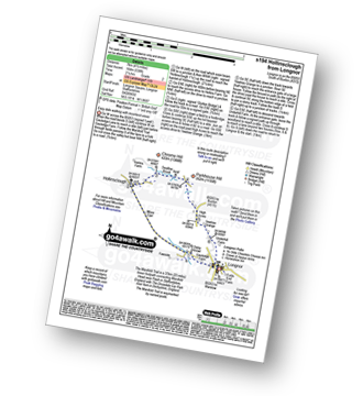
Longnor - The Manifold Trail - River Manifold - Lower Boothfold Farm - Ludburn Farm - Bridge End - The Ferns Farm - Heath House - Longnor
|
Vital Statistics:
| Length: | 4.75 miles (7.5 km) |
| Ascent: | 659ft (201m) |
| Time: | 2½ hrs |
| Grade: | |
Route Summary:
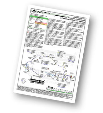
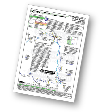
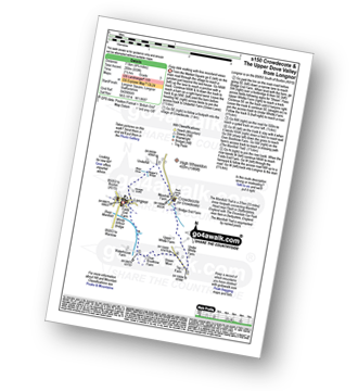
Longnor - Beggar's Bridge - River Dove - Crowdecote (Crowdicote) - Bridge End Farm - Under Wwhitle Farm - Over Boothlow Farm - The Manifold Trail - River Manifold - Longnor.
|
Vital Statistics:
| Length: | 7 miles (11 km) |
| Ascent: | 1,090ft (332m) |
| Time: | 3.75hrs |
| Grade: | |
Route Summary:
Longnor - The Manifold Trail - Gauledge Farm - Fawside Farm - The River Manifold - Hardings Booth - Hollinsclough Moor - Hollinsclough - Swallow Brook - Earl Sterndale - Abbotside Farm - Green Lane - Beaggar's Bridge - Longnor
|
Vital Statistics:
| Length: | 11 miles (17.5 km) |
| Ascent: | 1,342ft (409m) |
| Time: | 5.25hrs |
| Grade: | |
Route Summary:
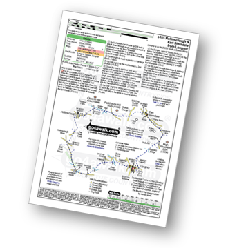
Longnor - River Manifold - The Manifold Trail - Over Boothlow Farm - Lower Boothlow Farm - Hill End Farm - Sheen Hill - Slate House Farm - Sheen - Brund - River Manifold - Brund Mill - New Road Farm - Field House Farm - Reaps Moor - Black Brook - Smedley Sytch - Boosley Grange - Fawfield Head - Bank House - Shining Ford - The Manifold Trail - Hardings Booth - Fawside Farm - Gauledge Farm,Longnor.
|
Vital Statistics:
| Length: | 7.5 miles (12 km) |
| Ascent: | 811ft (247m) |
| Time: | 3½ hrs |
| Grade: | |
Route Summary:
Longnor - The Manifold Trail - River Manifold - Lower Boothfold Farm - Ludburn Farm - Reaps Moor - Blake Brook - Boosley Grange - Bank House Farm - Shining Ford Farm - Hardings Booth Farm - Fawside Farm - Gualedge Farm - Longnor
|
Vital Statistics:
| Length: | 4.5 miles (7 km) |
| Ascent: | 834ft (254m) |
| Time: | 2½ hrs |
| Grade: | |
Route Summary:
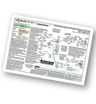
Longnor - River Dove - Beggar's Bridge - High Wheeldon - Abbotside Farm - Earl Sterndale - Hitter Hill - Parkhouse Hill - High Acres - Yewtree Grange - Underhill Farm - Longnor
|
Vital Statistics:
| Length: | 14.5 miles (23.5 km) |
| Ascent: | 3,049ft (929m) |
| Time: | 8½ hrs |
| Grade: | |
Route Summary:
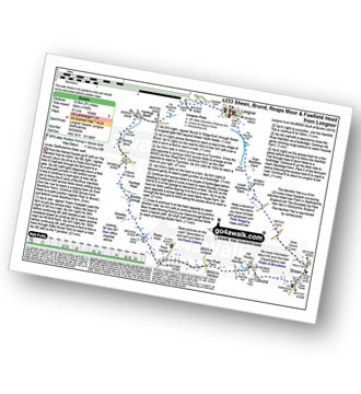
Longnor - The Manifold Trail - Gauledge Farm - Fawside Farm - The River Manifold - Hardings Booth - Ball Bank Farm - The River Manifold - Heathylee House - Hollinsclough Moor - Wilshaw Bottom - Wilshaw Farm - Moorside Farm - Hollinsclough - Hollins Farm - Swallow Brook - Parkhouse Hill - Hitter Hill - Earl Sterndale - Abbots Grove - Wheeldon Trees - High Wheeldon - Crowdecote - Bridge End Farm - Pilsbury Castle Hills - Pilsbury - Sheen Lane Farm - Ridge End Farm - The Manifold Trail - Lower Boothlow Farm - Folds End Farm - Longnor
|
Vital Statistics:
| Length: | 15 miles (24 km) |
| Ascent: | 1,831ft (558m) |
| Time: | 7.25hrs |
| Grade: | |
Route Summary:
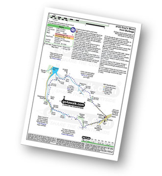
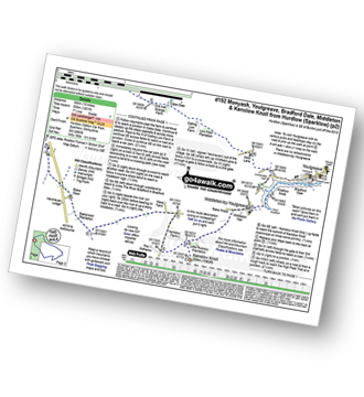
Hurdlow - Sparklow - The High Peak Trail - Hutmoor Butts - The Limestone Way - Monyash - One Ash Grange Farm - Calling Low Farm - Cales Dale - Moor Lane - Youlgreave - Lomberdale Hall - Middleton-by-Youlgreave - Rake Wood - Little Rookery Plantation - Kenslow Farm - Kenslow Knoll - Ringham Low (Friden) - Mere Farm - Green Lane (Friden) - The High Peak Trail - Sparklow - Hurdlow
|
Vital Statistics:
| Length: | 4 miles (6.5 km) |
| Ascent: | 942ft (287m) |
| Time: | 2½ hrs |
| Grade: | |
Route Summary:
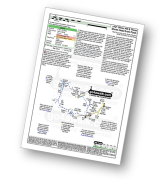
Flash - Oliver Hill - Knotbury Farm - Panniers Pool - Three Shires Head - The Dane Valley Way - River Dane - Wicken Walls Farm - Axe Edge Green Farm - Flash
|
Vital Statistics:
| Length: | 5 miles (8 km) |
| Ascent: | 991ft (302m) |
| Time: | 2.75hrs |
| Grade: | |
Route Summary:
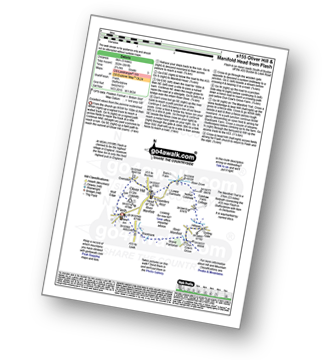
Flash - Oliver Hill - Oxensitch - River Manifold Head - River Dove - Nether Colshaw Farm - Golling Gate Farm - Dun Cow's Grove Farm - The Manifold Trail - Blackbank Farm - Flash
|
Vital Statistics:
| Length: | 10 miles (16 km) |
| Ascent: | 1,953ft (595m) |
| Time: | 5.75hrs |
| Grade: | |
Route Summary:
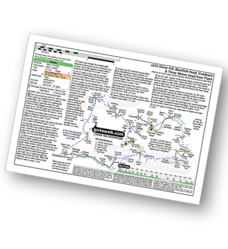
Flash - Oliver Hill - Oxensitch - River Manifold Head - River Dove - Nether Colshaw Farm - Golling Gate Farm - Dun Cow's Grove Farm - The Manifold Trail - Blackbank Farm - Wilson Knowl Farm - Lower House Farm - Culvert Farm - Tollbridge Cottage - Gradbach - The Dane Valley Way - Dane View House - River Dane - Three Shires Head - Panniers Pool - Knotbury Farm - Wolf Edge - Flash
|
Vital Statistics:
| Length: | 7.25 miles (11.5 km) |
| Ascent: | 1,411ft (430m) |
| Time: | 4 hrs |
| Grade: | |
Route Summary:
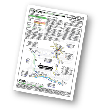
Tideswell - The Limestone Way - Monksdale House - Monks Dale - Miller's Dale Station - The Monsal Trail - Miller's Dale - The River Wye - Litton Mill - Tideswell Dale - Tideswell
|
Vital Statistics:
| Length: | 5.25 miles (8.5 km) |
| Ascent: | 709ft (216m) |
| Time: | 2.75hrs |
| Grade: | |
Route Summary:
Tideswell - Litton Dale - Litton - Tansley Dale - Cressbrook Dale - Peter's Stone - Wardlow Mires - Litton Edge - Lane Head - Tideswell
|
Vital Statistics:
| Length: | 6.5 miles (10.5 km) |
| Ascent: | 1,063ft (324m) |
| Time: | 3½ hrs |
| Grade: | |
Route Summary:
Tideswell - Litton - Tansley Dale - Cressbrook Dale - Cressbrook - The Monsal Trail - Water-cum-Jolly Dale - Litton Mill - Tideswell Dale - Litton Dale - Tideswell
Not familiar with the area around SK17?
See these 30 nearest walks to UK Postcode SK17 on a google map


