UK Postcode PE12 - The 30 nearest easy-to-follow, circular walk route maps to you
The thirty nearest easy-to-follow, circular walk route maps to you in UK Postcode PE12 in Walk Grade Order
The UK cities, towns and villages in Lincolnshire, England that have PE12 in their UK Postcode include:
• Aswick Grange • Chapelgate • Cowbit • Dawsmere • Fleet • Fleet Hargate • Gedney • Gedney Broadgate • Gedney Drove End • Gedney Dyke • Gedney Hill • Guy's Head • Holbeach • Holbeach Bank • Holbeach Clough • Holbeach Drove • Holbeach Hurn • Holbeach St Johns • Holbeach St Marks • Holbeach St Matthew • Little London • Long Sutton • Loosegate • Lutton • Moulton • Moulton Chapel • Moulton Seas End • Saracen's Head • Shepeau Stow • Sutton Bridge • Sutton Crosses • Sutton St Edmund • Sutton St James • Weston • Weston Hills • Whaplode • Whaplode Drove • Whaplode St Catherine •
Tap/mouse over a coloured circle (1-3 easy walks, 4-6 moderate walks, 7-9 hard walks) and click to select.
Scroll down the list of walks below & click on each walk title (in blue) to locate it on the map above.
   |
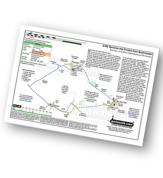
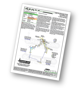
Vital Statistics:
| Length: | 7.25 miles (11.5 km) |
| Ascent: | 515ft (157m) |
| Time: | 3 hrs |
| Grade: |  |
|
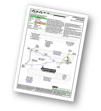
Vital Statistics:
| Length: | 8.75 miles (14 km) |
| Ascent: | 36ft (11m) |
| Time: | 3 hrs |
| Grade: |  |
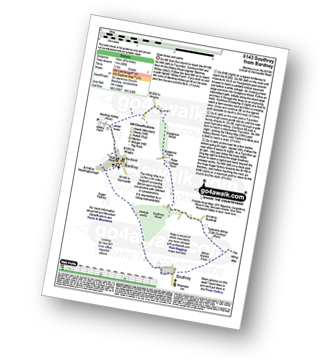
Route Summary:
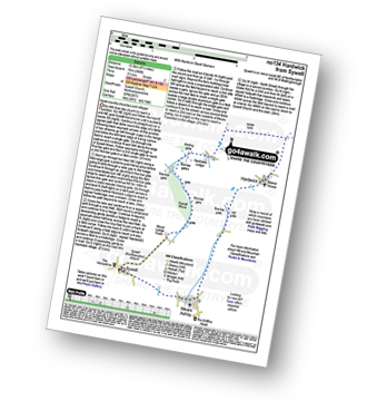
Bardney - Bardney Abbey - Young Wood - Southrey Wood - Tupholme Abbey - Southrey - The Viking Way - Bardney
|
Vital Statistics:
| Length: | 4.5 miles (7 km) |
| Ascent: | 295ft (90m) |
| Time: | 2 hrs |
| Grade: |  |
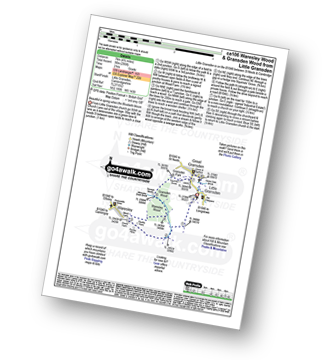
Route Summary:
Little Gransden - Waresley - Waresley Wood - Waresley Dean Brook - Gransden Wood - Squirrels' Grove - Gransden Park - Great Gransden - Home Dole Brook - Little Gransden
|
Vital Statistics:
| Length: | 6.5 miles (10 km) |
| Ascent: | 82ft (25m) |
| Time: | 2½ hrs |
| Grade: | |
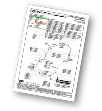
Route Summary:
Fulbourn - Harcamlow Way - Cole's Bridge - New Cut Drain - Hawk Mill Farm - Little Wilbraham - Great Wilbraham - Fleam Dyke - Fulbourn
|
Vital Statistics:
| Length: | 7.5 miles (12 km) |
| Ascent: | 252ft (77m) |
| Time: | 3 hrs |
| Grade: | |
Route Summary:
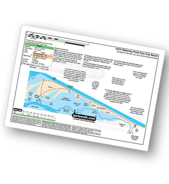
Cley Beach Car Park - The Marrams - Watch House (Halfway House) - The Hood - Blakeney Point - Lifeboat House - East Bar - Blakeney Point - The Hood - Watch House (Halfway House) - The Marrams - Cley Beach Car Park
|
Vital Statistics:
| Length: | 8.5 miles (13.5 km) |
| Ascent: | 246ft (75m) |
| Time: | 3½ hrs |
| Grade: | |
|
Vital Statistics:
| Length: | 6.5 miles (10 km) |
| Ascent: | 328ft (100m) |
| Time: | 2½ hrs |
| Grade: | |
Route Summary:
Turvey - Turvey Abbey - Priory Farm - Grotto Plantation - Hill Spinney - Ramacre Wood - Gorewell - The Milton Keynes Boundary Walk - Gullet Wood - Keepers (Church's) Cottage - Woodside - Turvey
|
Vital Statistics:
| Length: | 5.5 miles (9 km) |
| Ascent: | 670ft (204m) |
| Time: | 2.75hrs |
| Grade: | |
Route Summary:
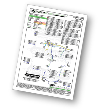
Sheringham - The Peddars Way and Norfolk Coast Path - Life Boat Station - Golf Course - Coast Watch Lookout Station - Sheringham Park - Oak Wood - Gazebo View Point - Sheringham Wood - Sheringham Temple - Hall Farm - Upper Sheringham - Sheringham
|
Vital Statistics:
| Length: | 6 miles (9.5 km) |
| Ascent: | 322ft (98m) |
| Time: | 2½ hrs |
| Grade: | |
Route Summary:
Felbrigg Hall - Felbrigg Park - Felbrigg Park Church - The Belt - Metton Carrs - Metton - The Weavers Way - Glen Farm Big Fen Plantation - Little Fen Plantation - Sustead Common - Brickfields - Allotment Plantation - Common Plantation - Felbrigg Pond - Roundwood Hill - Fellbrigg Hall.
|
Vital Statistics:
| Length: | 3.5 miles (5.5 km) |
| Ascent: | 98ft (30m) |
| Time: | 1½ hrs |
| Grade: | |
Route Summary:
- Norwich (The Forum) - The River Wensum - Fye Bridge - Cow Tower - Bishop's Bridge - Pulls Ferry - The Compleat Angler - Foundry Bridge - Millennium Bridge - Lady Julian Bridge - Carrow Bridge - The Devil's Tower (Eastern Boom Tower) - King Street - Wensum Lodge (a.k.a. The Music House) - Dragon Hall - St Peter of Parmentergate church - St Julian's Church - Novi Sad Friendship Bridge - Timber Hills - The Gardeners Arms (a.k.a. The Murderers) - The Lamb - St Peter Mancroft Church - The Guildhall - Norwich (The Forum)
|
Vital Statistics:
| Length: | 5.25 miles (8.5 km) |
| Ascent: | 292ft (89m) |
| Time: | 2.25hrs |
| Grade: | |
|
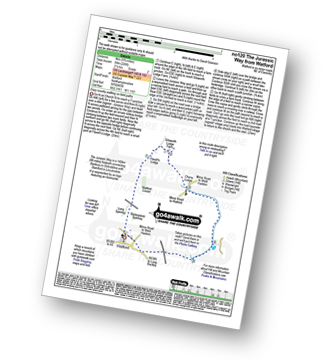
Vital Statistics:
| Length: | 6.5 miles (10.5 km) |
| Ascent: | 338ft (103m) |
| Time: | 2.75hrs |
| Grade: | |
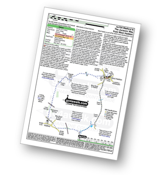
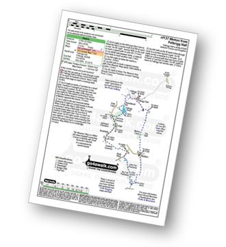
Route Summary:
West Haddon - Foxhill Farm - Watford - The Jurassic Way - Barleypiece Spinney - Long Spinney - Flavell's Lodge - Silsworth Lodge Farm - West Haddon
|
Vital Statistics:
| Length: | 5 miles (8 km) |
| Ascent: | 345ft (105m) |
| Time: | 2.25hrs |
| Grade: | |
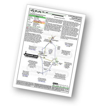
Route Summary:
Great Brington - Nobottle Wood - The Midshires Way - Nobottle - The Macmillan Way - Little Brington - Great Brington
|
Vital Statistics:
| Length: | 4.5 miles (7 km) |
| Ascent: | 407ft (124m) |
| Time: | 2 hrs |
| Grade: | |
Route Summary:
Clumber Park - Clumber Lake - Nursery Wood - Clumber Bridge - South Lawn - Five Thorns Plantation - Boat House Plantation - Tank Wood - Hardwick Grange - Hardwick Village - White Pleasant Wood - Ash Tree Wood - Clumber Park
|
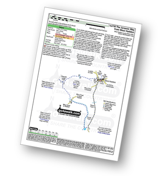
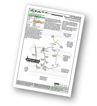
Vital Statistics:
| Length: | 5.75 miles (9 km) |
| Ascent: | 226ft (69m) |
| Time: | 2½ hrs |
| Grade: | |
Route Summary:
Watford - The Jurassic Way - Barleypiece Spinney - Long Spinney - Watford Covert - Flavell's Lodge - Silsworth Lodge Farm - Cherry Lodge - Watford
|
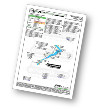
Vital Statistics:
| Length: | 4.25 miles (6.5 km) |
| Ascent: | 157ft (2,348m) |
| Time: | 1.75hrs |
| Grade: | |
Route Summary:
Worstead - Worstead Belt - Worstead Hall Farm - Chestnut Belt - Gothic Wood - Upper Street - Carman's Lane - Mucklefield Plantation - Dairyhouse Barn - Green Lane - Berard's Road - Worstead
|
Vital Statistics:
| Length: | 9 miles (14.5 km) |
| Ascent: | 33ft (10m) |
| Time: | 3½ hrs |
| Grade: | |
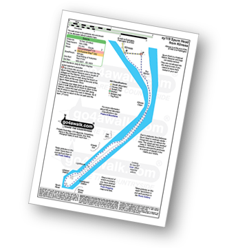
Route Summary:
Kilnsea - Spurn Head Peninsula - The Warren - Kilnsea Clays - Old Den - Greedy Gut - Low Light Lighthouse - Spurn Head - High Light Lighthouse - Stony Binks - Kilnsea
|
Vital Statistics:
| Length: | 6.25 miles (70 km) |
| Ascent: | 240ft (73m) |
| Time: | 2½ hrs |
| Grade: | |

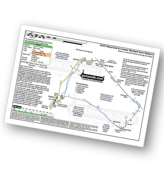
Route Summary:
Ardeley - Wood End - Roman Road - Hare Street - Roman Road - Hare Street - Cromer Windmill - Ardeley
|
Vital Statistics:
| Length: | 7.5 miles (12 km) |
| Ascent: | 315ft (96m) |
| Time: | 3 hrs |
| Grade: | |
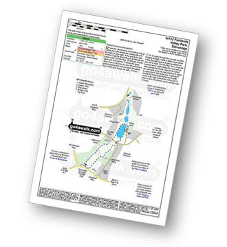
|
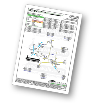
Vital Statistics:
| Length: | 4.75 miles (7.5 km) |
| Ascent: | 249ft (76m) |
| Time: | 2 hrs |
| Grade: | |

|
Vital Statistics:
| Length: | 2.25 miles (3.5 km) |
| Ascent: | 72ft (22m) |
| Time: | 1 hrs |
| Grade: | |
|
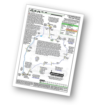
Vital Statistics:
| Length: | 7.75 miles (12.5 km) |
| Ascent: | 135ft (41m) |
| Time: | 3 hrs |
| Grade: | |
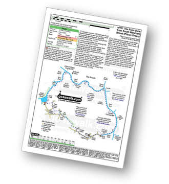
Route Summary:
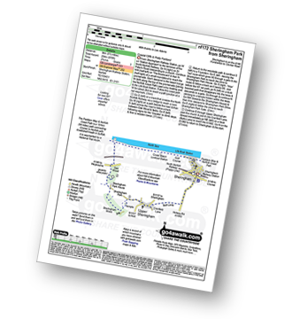
South Walsham Broad - Fleet Dike - Ward Marsh - St Benet's Abbey - River Bure - South Walsham Marshes - Thurne Mouth - Upton Marshes - Upton Black Drainage Mill - Ashby Oby Drainage & sawmill - Clippesby Mill - Upton Dyke - Palmer's Mill - Upton - Duckboards in Upton Broad and Marshes Nature Reserve - Cargate Green - Pilson Green - South Walsham Broad
|
Vital Statistics:
| Length: | 4.75 miles (7 km) |
| Ascent: | 394ft (120m) |
| Time: | 2 hrs |
| Grade: | |
|
Vital Statistics:
| Length: | 5.5 miles (9 km) |
| Ascent: | 499ft (152m) |
| Time: | 2½ hrs |
| Grade: | |
|
Vital Statistics:
| Length: | 7 miles (11 km) |
| Ascent: | 771ft (235m) |
| Time: | 3.25hrs |
| Grade: |  |
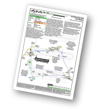
Route Summary:
Badby - Knightley Way - Badby Wood - Badby Down - Fawsley Hall - Everdon Hill - Everdon - Little Everdon - The Nene Way - River Nene - Newnham - Badby
|
Vital Statistics:
| Length: | 5.25 miles (8.5 km) |
| Ascent: | 43ft (13m) |
| Time: | 2 hrs |
| Grade: | |
Route Summary:
Ludham - Lovers Lane - Whitegates - How Hill National Nature Reserve - River Ant - Turf Fen Drainage Mill - Boardman's Drainage Mill - Clayrack Drainage Mill - The Mill House - Crome's Farm - Crome's Broad - Grove Farm - Waterpiece Lane - Catfield Road - Ludham
|
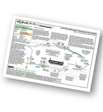
Vital Statistics:
| Length: | 6 miles (9.5 km) |
| Ascent: | 331ft (101m) |
| Time: | 2½ hrs |
| Grade: | |
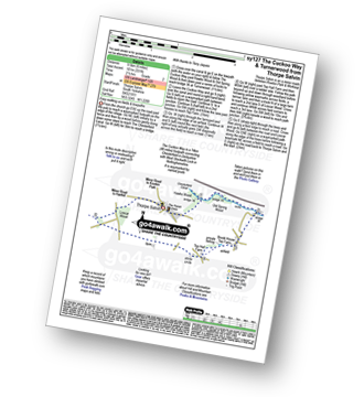
Route Summary:
Thorpe Salvin - Hawks Wood - The Cuckoo Way - Chesterfield Canal - Old Spring Wood - Turnerwood - Crow Wood - Thorpe Salvin
|
Vital Statistics:
| Length: | 9 miles (14.5 km) |
| Ascent: | 256ft (78m) |
| Time: | 3.75hrs |
| Grade: | |
Route Summary:
Takeley - Hope End Green - Cow Common - Hellman's Cross - Taverners Green - Hatfield Broad Oak - Three Forests Way - Pincy Brook - Bush End - Harcamlow Way - The Flitch Way - Takeley
|
Vital Statistics:
| Length: | 8.25 miles (13 km) |
| Ascent: | 404ft (123m) |
| Time: | 3½ hrs |
| Grade: | |
Route Summary:
Harthill - Woodall - The Cuckoo Way - Kiveton Waters - Chesterfield Canal - Kiveton - Kiveton Park - Hawks Wood - Thorpe Salvin - Loscar Wood - Crow Wood - Harthill
|
Vital Statistics:
| Length: | 10 miles (16 km) |
| Ascent: | 515ft (157m) |
| Time: | 4½ hrs |
| Grade: | |
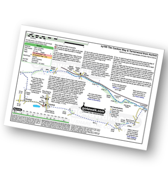
Route Summary:
Harthill - Woodall - The Cuckoo Way - Kiveton Waters - Chesterfield Canal - Kiveton - Kiveton Park - Hawks Wood - Old Spring Wood - Turnerwood - Brook House Top Farm - Top Hall Farm - Crow Wood - Harthill


