   |
Vital Statistics:
| Length: | 6mls (9.5km) |
| Ascent: | 322ft (98m) |
| Time: | 2½hrs |
| Grade: |  |
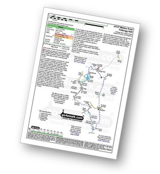
Route outline for walk nf137:
Felbrigg Hall - Felbrigg Park - Felbrigg Park Church - The Belt - Metton Carrs - Metton - The Weavers Way - Glen Farm Big Fen Plantation - Little Fen Plantation - Sustead Common - Brickfields - Allotment Plantation - Common Plantation - Felbrigg Pond - Roundwood Hill - Fellbrigg Hall.
National Trails & Long Paths included on this walk:
Part of this walk follows a section of The Weavers Way, a 90km (56 miles) linear footpath connecting Cromer in Norfolk, England with Great Yarmouth in Norfolk, England. The Weavers Way is waymarked by named posts. For more walks that include a section of this trail see The Weavers Way.
Free-to-access Interactive Walk Planning Maps:
1:25,000 scale OS Explorer Map (orange/yellow covers):
An Interactive Walk Planning Map for OS Explorer 252 Norfolk Coast East is not currently available
1:50,000 scale OS Landranger Map (pink/magenta covers):
An Interactive Walk Planning Map for OS Landranger 133 North East Norfolk, Cromer & Wroxham is not currently available
Send us your photographs and pictures from your walks and hikes
We would love to see your photographs and pictures from walk nf137 Metton from Felbrigg Hall. Send them in to us as email attachments (configured for any computer) along with your name and where the picture was taken to:
and we shall do our best to publish them.
(Guide Resolution = 300dpi. At least = 660 pixels (wide) x 440 pixels (high).)

You can also submit photos from walk nf137 Metton from Felbrigg Hall via our Facebook Page.
NB. Please indicate where each photo was taken.


