UK Postcode IP20 - The 30 nearest easy-to-follow, circular walk route maps to you
The thirty nearest easy-to-follow, circular walk route maps to you in UK Postcode IP20 in Walk Grade Order
The UK cities, towns and villages in Norfolk, England that have IP20 in their UK Postcode include:
• Alburgh • Denton • Great Green • Harleston • Homersfield • Mendham • Metfield • Needham • Piccadilly Corner • Redenhall • St Cross South Elmham • St Margaret South Elmham • Starston • Withersdale Street • Wortwell •
Tap/mouse over a coloured circle (1-3 easy walks, 4-6 moderate walks, 7-9 hard walks) and click to select.
Scroll down the list of walks below & click on each walk title (in blue) to locate it on the map above.
   |
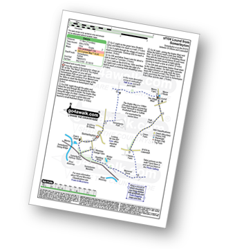
Vital Statistics:
| Length: | 7 miles (11 km) |
| Ascent: | 141ft (43m) |
| Time: | 3 hrs |
| Grade: |  |
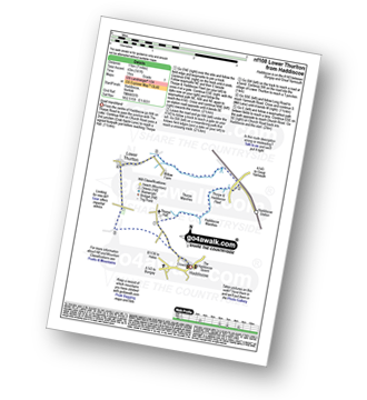
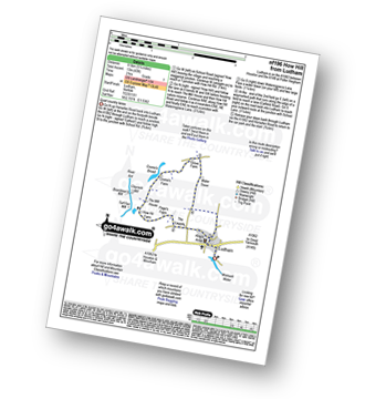
Route Summary:
Haddiscoe - Thorpe Road - Thorpe Hall - Haddiscoe Marshes - Thorpe Marshes - Thorpe and Haddiscoe Fleet - Haddiscoe Cut Bridge - Willow Farm - Marsh Farm - Lower Thurlton - Haddiscoe
|
Vital Statistics:
| Length: | 12.5 miles (20 km) |
| Ascent: | 347ft (106m) |
| Time: | 4.75hrs |
| Grade: |  |
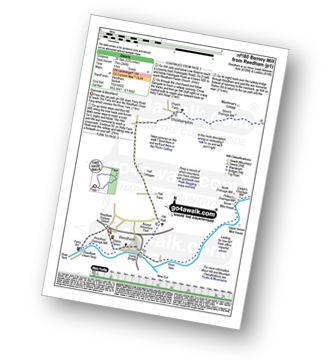
Route Summary:
Reedham - Reedham Chain Ferry - Wherryman's Way - Reedham Drainage Mill - River Yare - Reedham Marshes - Seven Mile House - Polkey's Drainage Mill - Cadge's Drainage Mill - Berney Arms Reach - Berney Arms Mill - The Weavers Way - Berney Marshes - Berney Arms Railway Station - Stone's Drainage Mill - Wickhampton Marshes - Wickhampton - Halvergate Road - Reedham Parish Church - Damgate - Holly Farm Road - Reedham
|
Vital Statistics:
| Length: | 3.5 miles (5.5 km) |
| Ascent: | 98ft (30m) |
| Time: | 1½ hrs |
| Grade: | |
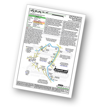
Route Summary:
- Norwich (The Forum) - The River Wensum - Fye Bridge - Cow Tower - Bishop's Bridge - Pulls Ferry - The Compleat Angler - Foundry Bridge - Millennium Bridge - Lady Julian Bridge - Carrow Bridge - The Devil's Tower (Eastern Boom Tower) - King Street - Wensum Lodge (a.k.a. The Music House) - Dragon Hall - St Peter of Parmentergate church - St Julian's Church - Novi Sad Friendship Bridge - Timber Hills - The Gardeners Arms (a.k.a. The Murderers) - The Lamb - St Peter Mancroft Church - The Guildhall - Norwich (The Forum)
|
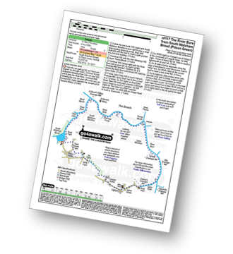
Vital Statistics:
| Length: | 5.5 miles (9 km) |
| Ascent: | 118ft (36m) |
| Time: | 2 hrs |
| Grade: | |
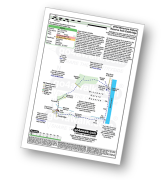
Route Summary:
Eastbridge - Sandpytle Plantation - The Sluice - Minsmere Nature Reserve - Coastguard Cottages - Dunwich Heath - Eastbridge
|
Vital Statistics:
| Length: | 7.25 miles (11.5 km) |
| Ascent: | 197ft (60m) |
| Time: | 3 hrs |
| Grade: |  |
Route Summary:
Somerleyton - The Angles Way - Somerleyton Park - Lound - Green Lane - Waddling Lane - The Angles Way - Wicker Well - Waddling Wood - Somerleyton Railway Station - Somerleyton
|
Vital Statistics:
| Length: | 9.25 miles (14.5 km) |
| Ascent: | 229ft (70m) |
| Time: | 3½ hrs |
| Grade: | |
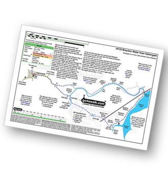
Route Summary:
Halvergate - The Weavers Way - Wickhampton Marshes - Berney Arms Railway Station - Berney Arms Mill - Berney Arms Reach - Breydon Water - Reedham Marshes - Beighton Marshes - Breydon Pump - The Fleet - Halvergate
|
Vital Statistics:
| Length: | 9 miles (14.5 km) |
| Ascent: | 125ft (38m) |
| Time: | 3½ hrs |
| Grade: | |
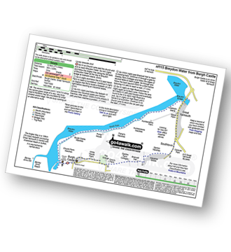
Route Summary:
Burgh Castle - Burgh Castle Roman Fort - The Angles Way - Breydon Water - Burgh Castle Marshes - Breydon Water Pump House - Fisher's Marshes - Humberstone Marshes - Breydon Bridge - Cobholm Island - Great Yarmouth - Southtown - Ganton Marshes - Bradwell Hall - Burgh Castle
|
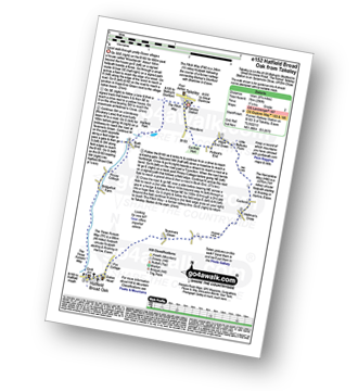
Vital Statistics:
| Length: | 7.75 miles (12.5 km) |
| Ascent: | 135ft (41m) |
| Time: | 3 hrs |
| Grade: | |
Route Summary:
South Walsham Broad - Fleet Dike - Ward Marsh - St Benet's Abbey - River Bure - South Walsham Marshes - Thurne Mouth - Upton Marshes - Upton Black Drainage Mill - Ashby Oby Drainage & sawmill - Clippesby Mill - Upton Dyke - Palmer's Mill - Upton - Duckboards in Upton Broad and Marshes Nature Reserve - Cargate Green - Pilson Green - South Walsham Broad
|
Vital Statistics:
| Length: | 5.25 miles (8.5 km) |
| Ascent: | 43ft (13m) |
| Time: | 2 hrs |
| Grade: | |
Route Summary:
Ludham - Lovers Lane - Whitegates - How Hill National Nature Reserve - River Ant - Turf Fen Drainage Mill - Boardman's Drainage Mill - Clayrack Drainage Mill - The Mill House - Crome's Farm - Crome's Broad - Grove Farm - Waterpiece Lane - Catfield Road - Ludham
|
Vital Statistics:
| Length: | 4.25 miles (6.5 km) |
| Ascent: | 157ft (2,348m) |
| Time: | 1.75hrs |
| Grade: | |
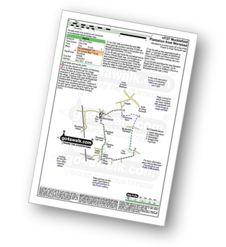
Route Summary:
Worstead - Worstead Belt - Worstead Hall Farm - Chestnut Belt - Gothic Wood - Upper Street - Carman's Lane - Mucklefield Plantation - Dairyhouse Barn - Green Lane - Berard's Road - Worstead
|
Vital Statistics:
| Length: | 6 miles (9.5 km) |
| Ascent: | 128ft (39m) |
| Time: | 2½ hrs |
| Grade: | |
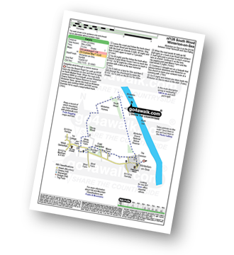
Route Summary:
Winterton-on-Sea - Winterton Dunes National Nature Reserve - South Wood - Decay Wood - White House Farm - East Somerton - Winterton-on-Sea
|
Vital Statistics:
| Length: | 9 miles (14.5 km) |
| Ascent: | 151ft (46m) |
| Time: | 3½ hrs |
| Grade: | |
Route Summary:
Winterton-on-Sea - Winterton Dunes National Nature Reserve - South Wood - Bramble Hill - Crinkle Hill - Horsey - Horsey Mill - Hundred Stream - Martham Broad National Nature Reserve - Martham Broad - West Somerton Mill - West Somerton - East Somerton - Winterton-on-Sea
|
Vital Statistics:
| Length: | 4.5 miles (7 km) |
| Ascent: | 207ft (63m) |
| Time: | 2 hrs |
| Grade: | |
Route Summary:
Wherstead - Wherstead Hall - Suffolk Food Hall - Redgate Farm - Freston Brook - The Stour and Orwell Walk - Freston Wood - Freston - Bond Hall Farm - Broom Knoll - Cutler's Wood - Stalls Valley - Valley Farm - Park Farm - Wherstead
|
Vital Statistics:
| Length: | 3.5 miles (5.5 km) |
| Ascent: | 91ft (28m) |
| Time: | 1½ hrs |
| Grade: | |
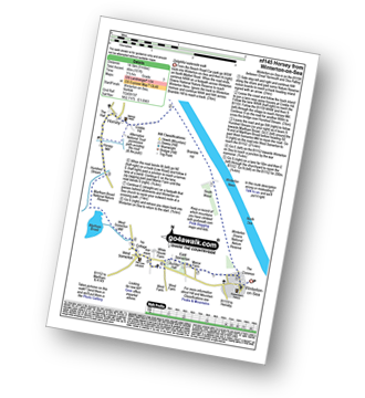
Route Summary:
Horsey Mill - Horsey Mere - Waxham New Cut - Brograve Drainage Mill - Horsey Corner - Horsey church - Horsey - National Trust Permissive Path - Horsey Mill
|
Vital Statistics:
| Length: | 6 miles (9.5 km) |
| Ascent: | 322ft (98m) |
| Time: | 2½ hrs |
| Grade: | |
Route Summary:
Felbrigg Hall - Felbrigg Park - Felbrigg Park Church - The Belt - Metton Carrs - Metton - The Weavers Way - Glen Farm Big Fen Plantation - Little Fen Plantation - Sustead Common - Brickfields - Allotment Plantation - Common Plantation - Felbrigg Pond - Roundwood Hill - Fellbrigg Hall.
|
Vital Statistics:
| Length: | 5.5 miles (9 km) |
| Ascent: | 670ft (204m) |
| Time: | 2.75hrs |
| Grade: | |
Route Summary:
Sheringham - The Peddars Way and Norfolk Coast Path - Life Boat Station - Golf Course - Coast Watch Lookout Station - Sheringham Park - Oak Wood - Gazebo View Point - Sheringham Wood - Sheringham Temple - Hall Farm - Upper Sheringham - Sheringham
|
Vital Statistics:
| Length: | 7.5 miles (12 km) |
| Ascent: | 252ft (77m) |
| Time: | 3 hrs |
| Grade: | |
Route Summary:
Cley Beach Car Park - The Marrams - Watch House (Halfway House) - The Hood - Blakeney Point - Lifeboat House - East Bar - Blakeney Point - The Hood - Watch House (Halfway House) - The Marrams - Cley Beach Car Park
|
Vital Statistics:
| Length: | 6.5 miles (10 km) |
| Ascent: | 82ft (25m) |
| Time: | 2½ hrs |
| Grade: | |
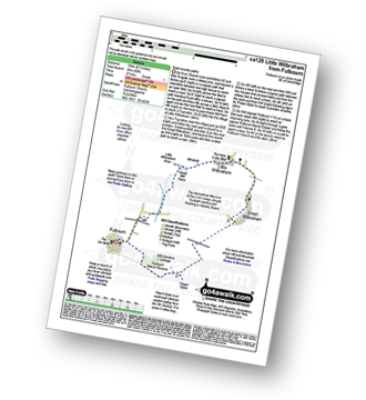
Route Summary:
Fulbourn - Harcamlow Way - Cole's Bridge - New Cut Drain - Hawk Mill Farm - Little Wilbraham - Great Wilbraham - Fleam Dyke - Fulbourn
|
Vital Statistics:
| Length: | 9 miles (14.5 km) |
| Ascent: | 256ft (78m) |
| Time: | 3.75hrs |
| Grade: | |
Route Summary:
Takeley - Hope End Green - Cow Common - Hellman's Cross - Taverners Green - Hatfield Broad Oak - Three Forests Way - Pincy Brook - Bush End - Harcamlow Way - The Flitch Way - Takeley
|
Vital Statistics:
| Length: | 4.5 miles (7 km) |
| Ascent: | 295ft (90m) |
| Time: | 2 hrs |
| Grade: | |
Route Summary:
Little Gransden - Waresley - Waresley Wood - Waresley Dean Brook - Gransden Wood - Squirrels' Grove - Gransden Park - Great Gransden - Home Dole Brook - Little Gransden
|
Vital Statistics:
| Length: | 6.25 miles (70 km) |
| Ascent: | 240ft (73m) |
| Time: | 2½ hrs |
| Grade: | |
Route Summary:
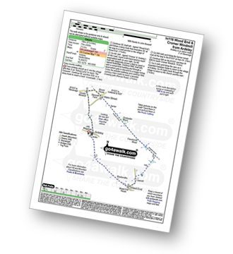
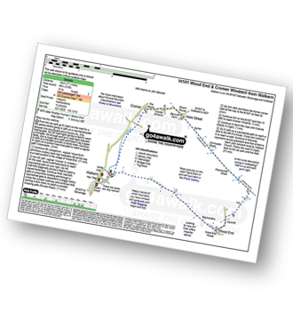
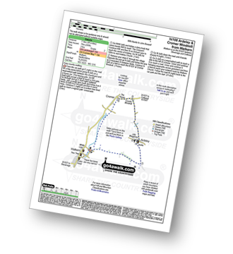
Ardeley - Wood End - Roman Road - Hare Street - Roman Road - Hare Street - Cromer Windmill - Ardeley
|
Vital Statistics:
| Length: | 7.5 miles (12 km) |
| Ascent: | 315ft (96m) |
| Time: | 3 hrs |
| Grade: | |
|
Vital Statistics:
| Length: | 4.75 miles (7.5 km) |
| Ascent: | 249ft (76m) |
| Time: | 2 hrs |
| Grade: | |
|
Vital Statistics:
| Length: | 7 miles (11 km) |
| Ascent: | 650ft (198m) |
| Time: | 3.25hrs |
| Grade: | |
Route Summary:
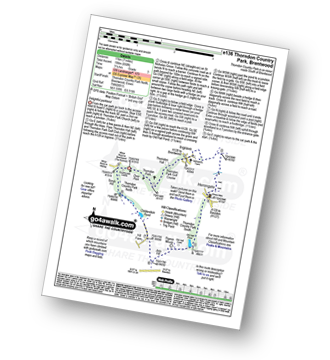
Thorndon Country Park North - Thorndon Park - Thorndon Hall - Ingrave - Herongate - Thorndon Country Park South - Old Hall Pond - Pigeon Mount - Jury Hill - Childerditch Pond - Scrub Hill - Countryside Centre - Thorndon Country Park North
|
Vital Statistics:
| Length: | 3.75 miles (6 km) |
| Ascent: | 161ft (49m) |
| Time: | 1½ hrs |
| Grade: | |
Route Summary:
Garlinge - Westbrook - Nr Margate - Minster Rd - Shottendane Rd - Woodchurch - Archer Farm - Hengrove Farm - Garlinge
|
Vital Statistics:
| Length: | 2.25 miles (3.5 km) |
| Ascent: | 72ft (22m) |
| Time: | 1 hrs |
| Grade: | |
|
Vital Statistics:
| Length: | 6.5 miles (10 km) |
| Ascent: | 328ft (100m) |
| Time: | 2½ hrs |
| Grade: | |
Route Summary:
Turvey - Turvey Abbey - Priory Farm - Grotto Plantation - Hill Spinney - Ramacre Wood - Gorewell - The Milton Keynes Boundary Walk - Gullet Wood - Keepers (Church's) Cottage - Woodside - Turvey
|
Vital Statistics:
| Length: | 5.25 miles (8.5 km) |
| Ascent: | 407ft (124m) |
| Time: | 2.25hrs |
| Grade: | |
|
Vital Statistics:
| Length: | 6.5 miles (10.5 km) |
| Ascent: | 637ft (194m) |
| Time: | 3 hrs |
| Grade: | |
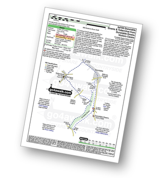
Route Summary:
Dunstable Downs Visitors Centre - The Icknield Way - Five Knolls - Drovers Way - Totternhoe - Well Head - Bison Hill - Dunstable Downs Visitors Centre
|
Vital Statistics:
| Length: | 7.25 miles (11.5 km) |
| Ascent: | 840ft (256m) |
| Time: | 3½ hrs |
| Grade: |  |
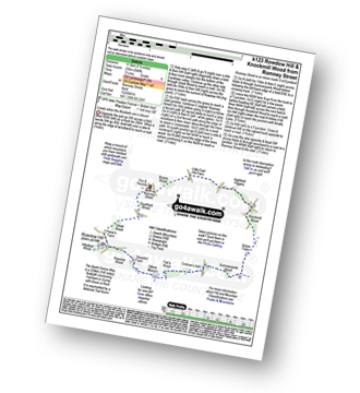
Route Summary:
Romney Street - Courtfield Wood - Eastdown - Great Wood - Paine's Farm - Rowdon Hill - The North Downs Way - Rowdow Wood - Shorehill Farm - Otford Manor - Fab's Wood - Cotman's Ash - Summeryards Wood - Knockmill Wood - Highfield Piggery - Little East Hill Farm - Broom Wood - Romney Street


