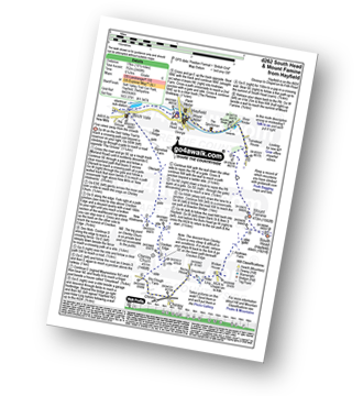
Eleven easy to follow pub walks from The Pack Horse, Hayfield, The Peak District, Derbyshire, England
To reach The Pack Horse, Hayfield, in-car SatNav users should select the Latitude/Longitude (Lat Lon) screen and enter:
Lat = N53.38054 and Lon = W 1.94601
Not familiar with this pub?
Eleven easy to follow pub walks from The Pack Horse, Hayfield, The Peak District, Derbyshire, England
Scroll down the list of walks below & click on each walk title (in blue) to locate it on the map above.
   |
Vital Statistics:
| Length: | 4.75 miles (7.5 km) |
| Ascent: | 899ft (274m) |
| Time: | 2.75hrs |
| Grade: |  |
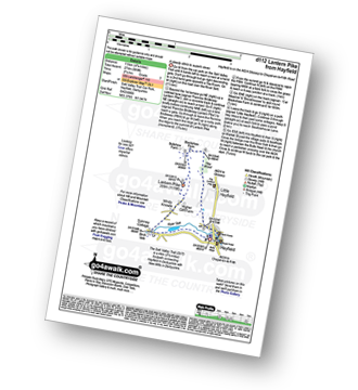
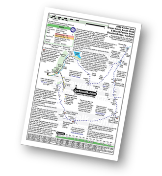
Route Summary:
Hayfield - Sett Valley Trail - Birch Vale - The River Sett - The Pennine Bridleway - Lantern Pike - Hey Wood - Little Hayfield - Sett Valley Trail - Hayfield
|
Vital Statistics:
| Length: | 4.75 miles (7.5 km) |
| Ascent: | 843ft (257m) |
| Time: | 2.75hrs |
| Grade: | |
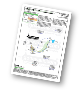
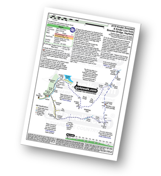
Route Summary:
Hayfield - Sett Valley Trail Car Park - Valley Road - Bowden Bridge Car Park - Kinder Road - Kinder Reservoir - White Brow - Middle Moor (Hayfield) - Snake Path - Sett Valley Trail Car Park - Hayfield
|
Vital Statistics:
| Length: | 7.5 miles (12 km) |
| Ascent: | 1,808ft (551m) |
| Time: | 4½ hrs |
| Grade: |  |
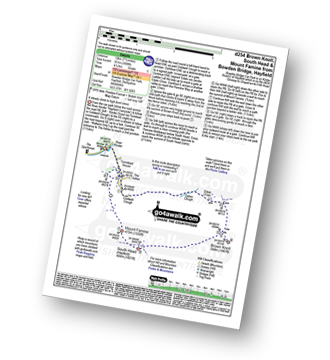
Route Summary:
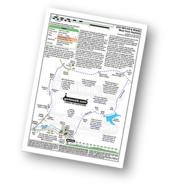
Bowden Bridge - Hayfield - Turnstead House - Coldwell Clough - Oaken Clough - Edale Cross - Brown Knoll (Edale) - South Head (Hayfield) - Mount Famine - Elle Bank - The Pennine Bridleway - Tunstead House - Bowden Bridge - Hayfield
|
Vital Statistics:
| Length: | 8.75 miles (14 km) |
| Ascent: | 1,861ft (567m) |
| Time: | 5 hrs |
| Grade: |  |
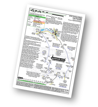
Route Summary:
Hayfield - Sett Valley Trail - Birch Vale - Morland Road - Ollersett - New Allotments - Chinley Churn - Cracken Edge - Chinley - Vorposten - Hayfield
|
Vital Statistics:
| Length: | 10.75 miles (17 km) |
| Ascent: | 2,242ft (683m) |
| Time: | 6.25hrs |
| Grade: | |
Route Summary:
Bowden Bridge - Hayfield - Booth Sheepwash - Farlands - Broad Clough - Kinderlow End - Three Knolls - Cluther Rocks - Red Brook - The Pennine Way - Kinder Downfall - Kinder Low (Kinder Scout) - Brown Knoll (Edale) - South Head (Hayfield) - Mount Famine - Elle Bank - The Pennine Bridleway - Tunstead House - Hayfield
|
Vital Statistics:
| Length: | 8.75 miles (14 km) |
| Ascent: | 1,851ft (564m) |
| Time: | 5 hrs |
| Grade: | |
Route Summary:
Bowden Bridge - Hayfield - Booth Sheepwash - Farlands - Broad Clough - Kinderlow End - Three Knolls - Cluther Rocks - Red Brook - The Pennine Way - Kinder Downfall - Kinder Low (Kinder Scout) - Edale Cross - Oaken Clough - Coldwell Clough - Bowden Bridge - Hayfield
|
Vital Statistics:
| Length: | 10.5 miles (17 km) |
| Ascent: | 2,055ft (626m) |
| Time: | 6 hrs |
| Grade: | |
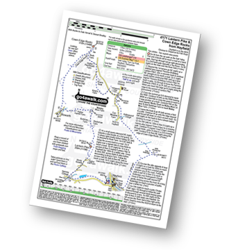
Route Summary:
Hayfield - Sett Valley Trail - Birch Vale - The River Sett - The Pennine Bridleway - Lantern Pike - Rowarth - Cown Edge Rocks - Chunal Road (Glossop) - Hollingwood Clough - Middle Moor (Hayfield) - The Snake Path - Hayfield
|
Vital Statistics:
| Length: | 8.75 miles (14 km) |
| Ascent: | 2,192ft (688m) |
| Time: | 5½ hrs |
| Grade: | |
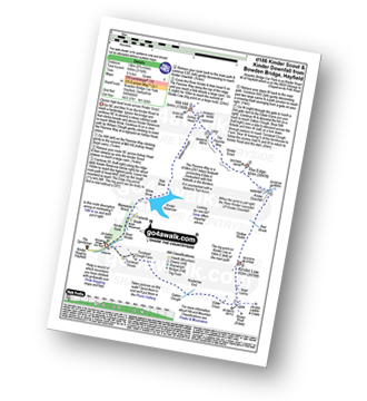
Route Summary:
Bowden Bridge - Hayfield - Booth Sheepwash - White Brow - Kinder Reservoir - Nab Brow - William Clough - Ashop Head - Mill Hill (Ashop Head) - The Pennine Way - Kinder Scout - The Edge (Kinder Scout) - Kinder Downfall - Red Brook - Cluther Rocks - Kinder Low (Kinder Scout) - Edale Cross - Kinderlow End - Oaken Clough - Tunstead House Farm - Bowden Bridge - Hayfield
|
Vital Statistics:
| Length: | 10.5 miles (17 km) |
| Ascent: | 2,468ft (752m) |
| Time: | 6.25hrs |
| Grade: | |
Route Summary:
Hayfield - Sett Valley Trail - Birch Vale - Morland Road - Ollersett - New Allotments - Cracken Edge - Chinley Churn - Chinley Head - Dry Clough Farm - Chinley - Naze House - Greystead - Alder Ling - Wicken House - Andrews Farm - South Head (Hayfield) - Mount Famine - Elle Bank - Pennine Bridleway - Tunstead House - Bowden Bridge - Hayfield
|
Vital Statistics:
| Length: | 9.5 miles (15 km) |
| Ascent: | 2,074ft (632m) |
| Time: | 5½ hrs |
| Grade: | |
Route Summary:
Hayfield - Sett Valley Trail - Birch Vale - The River Sett - The Pennine Bridleway - Lantern Pike - Matley Moor - Burnt Hill - Mill Hill (Ashop Head) - The Pennine Way - William Clough - Kinder Reservoir - Snake Path - Middle Moor - Hayfield
|
Vital Statistics:
| Length: | 13.5 miles (21.5 km) |
| Ascent: | 2,914ft (888m) |
| Time: | 7.75hrs |
| Grade: |  |
Route Summary:
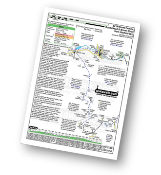
Hayfield - Sett Valley Trail - Birch Vale - Morland Road - Ollersett - New Allotments - Chinley Head - Mount Famine - South Head (Hayfield) - Brown Knoll (Edale) - Edale Cross - Oaken Clough - Coldwell Clough - Tunstead House - Bowden Bridge - Hayfield


