Ten easy to follow pub walks from The White Lion, Ambleside, The Lake District, Cumbria, England
To reach The White Lion, Ambleside, in-car SatNav users should select the Latitude/Longitude (Lat Lon) screen and enter:
Lat = N54.43101 and Lon = W 2.96207
Get directions to The White Lion in Ambleside
Ten easy to follow pub walks from The White Lion, Ambleside, The Lake District, Cumbria, England
To reach The White Lion, Ambleside, in-car SatNav users should select the Latitude/Longitude (Lat Lon) screen and enter:
Lat = N54.43101 and Lon = W 2.96207
Get directions to The White Lion in Ambleside
Scroll down the list of walks below & click on each walk title (in blue) to locate it on the map above.
   |
Vital Statistics:
| Length: | 8.75 miles (14 km) |
| Ascent: | 558ft (170m) |
| Time: | 3½ hrs |
| Grade: |  |
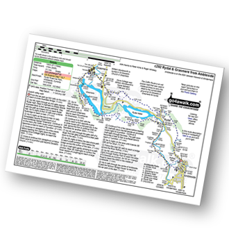
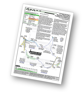
Route Summary:
Ambleside - Scandale Beck - Rydal Park - Rydal Hall - Rydal - Rydal Mount - Rydal Water - Coffin Route - Dove Cottage - Grasmere Village - Silverhowe - The Lea - Grasmere - Red Bank - Rydal Cave - Jobson Close - Rough Intake - Pelter Bridge - Foxghyll - River Rothay - Rothay Park - Ambleside
|
Vital Statistics:
| Length: | 3.25 miles (5 km) |
| Ascent: | 1,428ft (435m) |
| Time: | 2½ hrs |
| Grade: | |
|
Vital Statistics:
| Length: | 6 miles (9.5 km) |
| Ascent: | 1,401ft (427m) |
| Time: | 3½ hrs |
| Grade: |  |
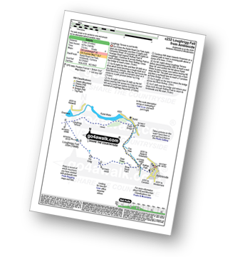
Route Summary:
Ambleside - Rothay Park - Ivy Fell - Loughrigg Fell - Loughrigg Terrace - Rydal Water - Loughrigg Caves - River Rothay - Pelter Bridge - Ambleside
|
Vital Statistics:
| Length: | 5 miles (8 km) |
| Ascent: | 1,769ft (539m) |
| Time: | 3.75hrs |
| Grade: | |
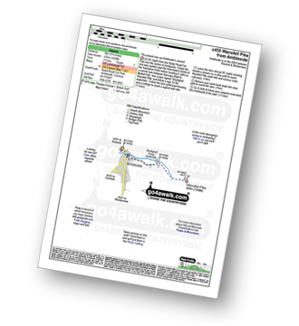
Route Summary:
Ambleside - Stockghyll Force - Wansfell Pike - Baystones (Wansfell) - Wansfell Pike - Stockghyll Force - Ambleside
|
Vital Statistics:
| Length: | 6 miles (9.5 km) |
| Ascent: | 2,192ft (668m) |
| Time: | 5 hrs |
| Grade: |  |
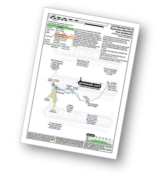
Route Summary:
Ambleside - Stockghyll Force - Wansfell Pike - Baystones (Wansfell) - The Hundreds - Nanny Lane - Troutbeck - Robin Lane - High Skelghyll Farm - Skelghyll Wood - Jenkin Crag - Ambleside
|
Vital Statistics:
| Length: | 7.5 miles (12 km) |
| Ascent: | 2,519ft (768m) |
| Time: | 5.25hrs |
| Grade: |  |
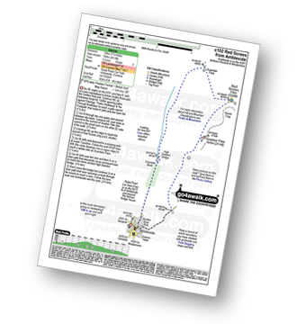
Route Summary:
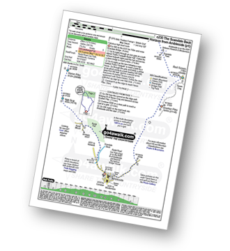
Ambleside - Snarker Pike - Red Screes - Scandale Pass - High Sweden Bridge - Ambleside
|
Vital Statistics:
| Length: | 9.75 miles (15.5 km) |
| Ascent: | 3,551ft (1,082m) |
| Time: | 7.25hrs |
| Grade: |  |
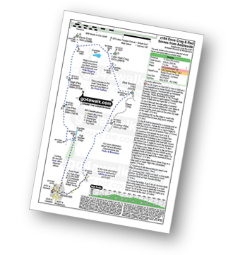
Route Summary:
Ambleside - Snarker Pike - Red Screes - Scandale Pass - Little Hart Crag - Dove Crag - High Pike (Scandale) - Low Pike (Scandale) - High Sweden Bridge - Ambleside
|
Vital Statistics:
| Length: | 11 miles (17.5 km) |
| Ascent: | 3,633ft (1,107m) |
| Time: | 7.75hrs |
| Grade: | |
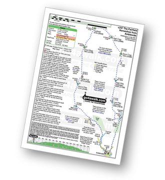
Route Summary:
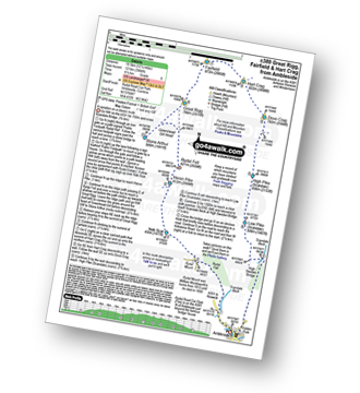
Ambleside - Rydal - Nab Scar - Heron Pike - Rydal Fell (Heron Pike North Top) - Great Rigg - Fairfield - Rydal Head - Hart Crag - Dove Crag - High Pike (Scandale) - Low Pike (Scandale) - High Sweden Bridge - High Sweden Coppice - Ambleside
|
Vital Statistics:
| Length: | 12.5 miles (20 km) |
| Ascent: | 3,411ft (1,040m) |
| Time: | 8 hrs |
| Grade: |  |
Route Summary:
Ambleside - Rydal - Nab Scar - Heron Pike - Rydal Fell (Heron Pike North Top) - Great Rigg - Fairfield - Rydal Head - Hart Crag - Dove Crag - Little Hart Crag - Scandale Pass - Red Screes - Snarker Pike - Ambleside
|
Vital Statistics:
| Length: | 12.25 miles (19.5 km) |
| Ascent: | 3,984ft (1,214m) |
| Time: | 8½ hrs |
| Grade: | |
Route Summary:
Ambleside - Rydal - Nab Scar - Heron Pike - Rydal Fell (Heron Pike North Top) - Greenhead Gill Head - Stone Arthur - Great Rigg - Fairfield - Rydal Head - Hart Crag - Dove Crag - High Pike (Scandale) - Low Pike (Scandale) - High Sweden Bridge - High Sweden Coppice - Ambleside


