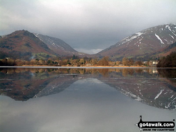
Helm Crag & Steel Fell (left), Grasmere Village & Dunmail Raise (centre) and Seat Sandal (right) beautifully reflected in Grasmere
The Lake District National Park,
Cumbria, England
See views like this by using any of these 13 easy-to-follow circular walk route maps:
   |
Vital Statistics:
| Length: | 8.75 miles (14 km) |
| Ascent: | 558ft (170m) |
| Time: | 3½ hrs |
| Grade: |  |
Route Summary:
Ambleside - Scandale Beck - Rydal Park - Rydal Hall - Rydal - Rydal Mount - Rydal Water - Coffin Route - Dove Cottage - Grasmere Village - Silverhowe - The Lea - Grasmere - Red Bank - Rydal Cave - Jobson Close - Rough Intake - Pelter Bridge - Foxghyll - River Rothay - Rothay Park - Ambleside
|
Vital Statistics:
| Length: | 3.75 miles (6 km) |
| Ascent: | 1,201ft (366m) |
| Time: | 3 hrs |
| Grade: | |
Route Summary:
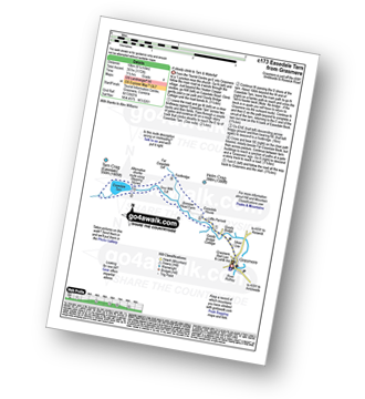
Grasmere - Goody Bridge - Wainwright's Coast to Coast Walk - Easedale House - High Raven Crag - Helm Crag - The Lion and The Lamb - The Howitzer - Goody Bridge - Grasmere
|
Vital Statistics:
| Length: | 4.5 miles (7.5 km) |
| Ascent: | 1,296ft (395m) |
| Time: | 3 hrs |
| Grade: |  |
|
Vital Statistics:
| Length: | 6.25 miles (10 km) |
| Ascent: | 1,172ft (357m) |
| Time: | 3½ hrs |
| Grade: | |
Route Summary:
Grasmere - Goody Bridge - Easedale Beck - Sourmilk Gill - Brinhowe Crag - Easedale - Sourmilk Falls - Easedale Tarn - Far Easedale Gill - Stythwaite Steps - Grasmere
|
Vital Statistics:
| Length: | 8.75 miles (14 km) |
| Ascent: | 2,212ft (674m) |
| Time: | 5½ hrs |
| Grade: |  |
Route Summary:
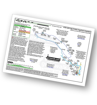
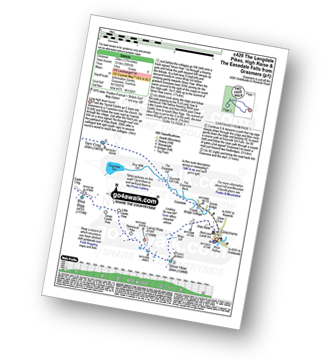
Grasmere - Goody Bridge - High Raven Crag - Helm Crag - The Lion and The Lamb - The Howitzer - Gibson Knott - Calf Crag - Wainwright's Coast to Coast Walk - Brownrigg Moss - Moor Moss - Far Easdale Gill - Goody Bridge - Grasmere
|
Vital Statistics:
| Length: | 8.5 miles (13.5 km) |
| Ascent: | 2,402ft (732m) |
| Time: | 5½ hrs |
| Grade: | |
Route Summary:
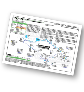
Grasmere - Castle How - Blea Rigg - Easedale Tarn - Sour Milk Gill - Easedale - Goody Bridge - Grasmere
|
Vital Statistics:
| Length: | 7 miles (11 km) |
| Ascent: | 2,661ft (811m) |
| Time: | 5.25hrs |
| Grade: | |
Route Summary:
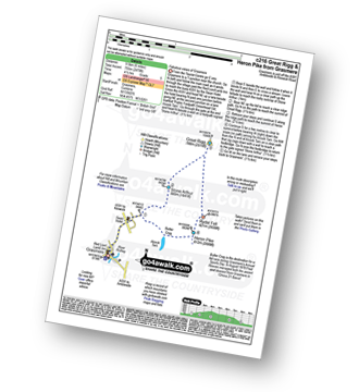
Grasmere - River Rothay - Grasmere (A591) - Stone Arthur - Great Rigg - Rydal Fell (Heron Pike North Top) - Heron Pike - Butter Crag - Alcock Tarn - Brackenfell - Dove Cottage - Grasmere (A591) - Grasmere
|
Vital Statistics:
| Length: | 7.5 miles (12 km) |
| Ascent: | 3,116ft (950m) |
| Time: | 6 hrs |
| Grade: | |
Route Summary:
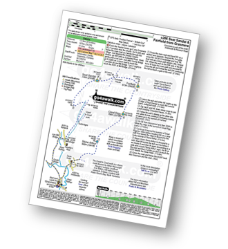
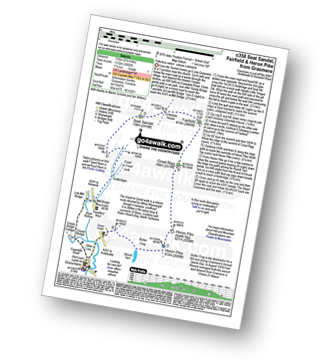
Grasmere - Wainwright's Coast to Coast Walk - Mill Bridge - Little Tongue - Seat Sandal - Grisedale Tarn - Fairfield - Rydal Head - Great Rigg - Stone Arthur - Grasmere
|
Vital Statistics:
| Length: | 8.5 miles (13.5 km) |
| Ascent: | 2,435ft (742m) |
| Time: | 5½ hrs |
| Grade: | |
Route Summary:
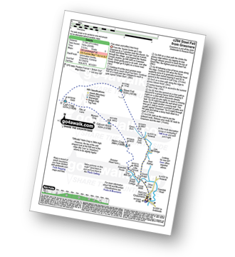
Grasmere - Goody Bridge - Ghyll Foot Farm - Green Burn - Greenburn Bottom - Contra Breast - Dead Pike - Steel Fell (Dead Pike) - Brownrigg Moss - Calf Crag - Gibson Knott - Helm Crag - The Lion and The Lamb - The Howitzer - High Raven Crag - Grasmere
|
Vital Statistics:
| Length: | 10 miles (16 km) |
| Ascent: | 2,936ft (895m) |
| Time: | 6½ hrs |
| Grade: |  |
Route Summary:
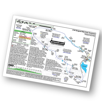
Grasmere - Sour Milk Gill - Sourmilk Gill Falls - Tarn Crag (Easedale) - Sergeant Man - Blea Rigg - Great Castle How - Little Castle How - Raw Pike - Swinescar Pike - Lang How - Silver How - Spedding Crag - Dow Bank - Huntingstile Crag - Grasmere
|
Vital Statistics:
| Length: | 10.25 miles (16.5 km) |
| Ascent: | 3,128ft (953m) |
| Time: | 6.75hrs |
| Grade: | |
Route Summary:
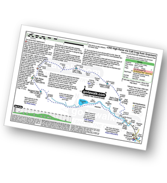
Grasmere - Goody Bridge - High Raven Crag - Helm Crag - The Lion and The Lamb - The Howitzer - Gibson Knott - Calf Crag - Brownrigg Moss - Greenup Edge - High Raise (Langdale) - Sergeant Man - Belles Knott - Coledale Tarn - Easedale Tarn - Sour Milk Gill - Easedale - Grasmere
|
Vital Statistics:
| Length: | 9.5 miles (15 km) |
| Ascent: | 3,682ft (1,122m) |
| Time: | 7.25hrs |
| Grade: | |
Route Summary:
Grasmere - Mill Bridge - Little Tongue - Seat Sandal - Grisedale Tarn - Fairfield - Rydal Head - Great Rigg - Rydal Fell (Heron Pike North Top) - Heron Pike - Alcock Tarn - Grasmere
|
Vital Statistics:
| Length: | 13.75 miles (22 km) |
| Ascent: | 3,991ft (1,216m) |
| Time: | 9 hrs |
| Grade: |  |
Route Summary:
Grasmere - Allan Bank - Wray Gill - Silver How - Lang How - Sinescar Pike - Little Castle How - Great Castle How - Blea Rigg - Sergeant Man - Thunacar Knott - Pavey Ark - Harrison Stickle - Loft Crag - Pike of Stickle (Pike O' Stickle) - High Raise (Langdale) - Codale Head - Tarn Crag (Easedale) - Far Easedale Gill - Sourmilk Falls - Far Easedale Beck - Goody Bridge - Grasmere
Send us your photographs and pictures of walks and hikes in the British countryside
If you would like to see your digital photographs as part of this collection, please send them as email attachments (configured for any computer) along with your name to:
and we shall do our best to publish them.
(Guide Resolution = 300dpi. At least = 587 pixels (wide) x 440 pixels (high).)

You can also submit photos via our Facebook Page.
NB. Please indicate where each photo was taken.
NB. To see photographs and pictures from a particular walk choose your walk from Walks or use our Walk Search facility.
To see photographs and pictures on, of or from a particular Mountain, Peak, Top or Hill select from Peaks & Mountains' or enter the Mountain, Peak, Top or Hill Name into our 'Photo Search facility.


