The Shropshire Hills - a fully detailed list of all the Peaks, Tops and Hills (Page 1 of 3)
The Shropshire Hills are located in Central England covering the south western part of Shropshire.
If you include all the Deweys, the Marilyns, the Bridgets (Hills) and all the Mountains, Tops, Peaks and Hills with a Trig Point on them there are 71 tops to climb, bag & conquer and the highest point is Brown Clee Hill (Abdon Burf) at 540m (1,772ft).
To see these Mountains, Peaks, Tops and Hills displayed in different ways - see the options in the left-hand column and towards the bottom of this page.
![]() Your Personal Bagging Record for The Shropshire Hills
Your Personal Bagging Record for The Shropshire Hills
LOG ON and RELOAD this page to show which Mountains, Peaks, Tops and Hills you have already climbed, bagged & conquered [. . . more details]
See this list in: Alphabetical Order‡
| Height Order
To reverse the order select the link again.
Mountain, Peak, Top or Hill:
Bagged

![]()
1. Yearlet
466m (1,529ft)
Yearlet is on interactive maps:
Yearlet is on downloadable PDF you can Print or Save to your Phone: |
![]()
2. Wolverton Wood
255m (836ft)
Wolverton Wood is on interactive maps:
Wolverton Wood is on downloadable PDF you can Print or Save to your Phone: |

![]()
3. Wart Hill
324m (1,063ft)
Wart Hill is on interactive maps:
Wart Hill is on downloadable PDF you can Print or Save to your Phone: |

![]()
4. View Edge (Weo Edge)
321m (1,054ft)
View Edge (Weo Edge) is on interactive maps:
View Edge (Weo Edge) is on downloadable PDF you can Print or Save to your Phone: |
![]()
5. Topley Plantation
301m (987ft)
Topley Plantation is on interactive maps:
Topley Plantation is on downloadable PDF you can Print or Save to your Phone: |

![]()
6. Titterstone Clee Hill
533m (1,749ft)
Titterstone Clee Hill is on interactive maps:
Titterstone Clee Hill is on downloadable PDF you can Print or Save to your Phone: |

![]()
7. The Wrekin
407m (1,335ft)
The Wrekin is on interactive maps:
The Wrekin is on downloadable PDF you can Print or Save to your Phone: |
![]()
8. The Lawley
377m (1,237ft)
The Lawley is on interactive maps:
The Lawley is on downloadable PDF you can Print or Save to your Phone: |
![]()
9. Switchback Hill
373m (1,224ft)
Switchback Hill is on interactive maps:
Switchback Hill is on downloadable PDF you can Print or Save to your Phone: |
![]()
10. Sunnyhill
393m (1,289ft)
Sunnyhill is on interactive maps:
Sunnyhill is on downloadable PDF you can Print or Save to your Phone: |
![]()
11. Stow Hill
441m (1,447ft)
Stow Hill is on interactive maps:
Stow Hill is on downloadable PDF you can Print or Save to your Phone: |
![]()
12. Stiperstones (Manstone Rock)
536m (1,759ft)
Stiperstones (Manstone Rock) is on interactive maps:
Stiperstones (Manstone Rock) is on downloadable PDF you can Print or Save to your Phone: |
![]()
13. Steppleknoll
365m (1,197ft)
Steppleknoll is on interactive maps:
Steppleknoll is on downloadable PDF you can Print or Save to your Phone: |
![]()
14. Stapeley Hill
403m (1,322ft)
Stapeley Hill is on interactive maps:
Stapeley Hill is on downloadable PDF you can Print or Save to your Phone: |
![]()
15. Short Wood
313m (1,027ft)
Short Wood is on interactive maps:
Short Wood is on downloadable PDF you can Print or Save to your Phone: |
![]()
16. Shelve Hill
381m (1,250ft)
Shelve Hill is on interactive maps:
Shelve Hill is on downloadable PDF you can Print or Save to your Phone: |
![]()
17. Roveries Wood
262m (859ft)
Roveries Wood is on interactive maps:
Roveries Wood is on downloadable PDF you can Print or Save to your Phone: |
![]()
18. Roman Bank
279m (915ft)
Roman Bank is on interactive maps:
Roman Bank is on downloadable PDF you can Print or Save to your Phone: |
![]()
19. Ragleth Hill
398m (1,306ft)
Ragleth Hill is on interactive maps:
Ragleth Hill is on downloadable PDF you can Print or Save to your Phone: |
![]()
20. Radnor Wood
325m (1,066ft)
Radnor Wood is on interactive maps:
Radnor Wood is on downloadable PDF you can Print or Save to your Phone: |
![]()
21. Pole Wood
302m (991ft)
Pole Wood is on interactive maps:
Pole Wood is on downloadable PDF you can Print or Save to your Phone: |
![]()
22. Pole Bank (Long Mynd)
516m (1,693ft)
Pole Bank (Long Mynd) is on interactive maps:
Pole Bank (Long Mynd) is on downloadable PDF you can Print or Save to your Phone: |
![]()
23. Oaker Wood
243m (797ft)
Oaker Wood is on interactive maps:
Oaker Wood is on downloadable PDF you can Print or Save to your Phone: |
![]()
24. Oakeley Mynd
309m (1,014ft)
Oakeley Mynd is on interactive maps:
|
![]()
25. Nover's Hill
305m (1,001ft)
Nover's Hill is on interactive maps:
Nover's Hill is on downloadable PDF you can Print or Save to your Phone: |
![]()
26. Norton Camp
294m (964ft)
Norton Camp is on interactive maps:
|
![]()
27. Norbury Hill (Linley Hill)
411m (1,348ft)
Send it in and we'll publish it here.
Norbury Hill (Linley Hill) is on interactive maps:
Norbury Hill (Linley Hill) is on downloadable PDF you can Print or Save to your Phone: |
![]()
28. Nick Knolls
374m (1,227ft)
Nick Knolls is on interactive maps:
Nick Knolls is on downloadable PDF you can Print or Save to your Phone: |
![]()
29. Mucklewick Hill
371m (1,217ft)
Mucklewick Hill is on interactive maps:
Mucklewick Hill is on downloadable PDF you can Print or Save to your Phone: |
![]()
30. Mogg Forest
289m (948ft)
Mogg Forest is on interactive maps:
Mogg Forest is on downloadable PDF you can Print or Save to your Phone: |
View these 71 Mountains, Peaks, Tops and Hills:
- On a Downloadable PDF you can Print or Save to your Phone#
- On an Interactive Google Map (loads faster)
- On an Interactive Google Map with a list of tops below it.
(makes it easier to locate a particular top) - On a Detailed List in:
Alphabetical Order | Height Order - On one page with 'yet-to-be-bagged' listed 1st & then 'already-bagged' tops listed 2nd in:
Alphabetical Order | Height Order - On one page with 'already-bagged' tops listed 1st & then 'yet-to-be-bagged' tops listed 2nd in:
Alphabetical Order | Height Order
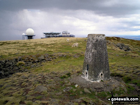
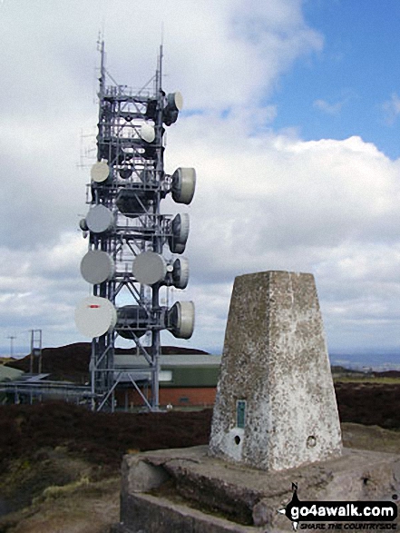 The summit of Brown Clee Hill (Abdon Burf) in The Shropshire Hills
Photo: Bruce McDowell
# Whether you print a copy or download it to your phone, this Peak Baggers' Map will prove incredibly useful if you want to know what's what when you are up in the mountains and cannot get a phone signal.
Is there a Mountain, Peak, Top or Hill missing from the above google map or list?
Let us know an we will add it to our database.
To contribute to go4awalk.com or to contact us about anything at all - see Talk To Us.
For help see Help.
go4awalk.com and go4awalk.co.uk are registered trademarks of TMDH Limited.
Copyright © 2000-2025 TMDH Limited. All rights reserved.
Copyright Terms & Conditions Privacy Statement
A - Z Walks Home Log On/Accounts Photo Gallery Walk Ideas and Collections Fell Facts Hill Skills Walking Questions and Answers Your Stories News Competitions Product Reviews/Gear Tests Walking Gear Guides Peaks and Mountains Peak Bagging Find New Walking Friends Camping GPS Waypoints for Walking Contents Walk Search Talk To Us go4awalk.com Help Free Example Walks Newsletter


