All the Mountains, Peaks, Tops and Hills in The North Pennines with all the tops you are yet to climb first & then the ones you have already bagged second
The North Pennines is located in Northern England covering parts of Cumbria, County Durham and Northumberland.
If you include the Marilyns, the Bridgets (Hills) and all the Mountains, Tops, Peaks and Hills with a Trig Point on them there are 59 tops to climb, bag & conquer and the highest point is Cross Fell at 893m (2,931ft).
To see these Mountains, Peaks, Tops and Hills displayed in different ways - see the options in the left-hand column and towards the bottom of this page.
![]() Your Personal Bagging Record for The North Pennines
Your Personal Bagging Record for The North Pennines
When logged on, you can mark each Mountain, Peak, Top or Hill as 'bagged' by either:
- if you opt to display the tops in this area using a google map, click or tap on its symbol on the map below. This will open a text window. Click or tap on the 'Record [mountain name] as Bagged, Climbed & Conquered' link towards the bottom of the text window, or
- if you opt to display the tops in this area as a list, click or tap on the red 'not yet' symbol to the right of the name of each 'top'
Either method will open a new page where you can complete all your details such as:
- when you bagged the Mountain, Peak, Top or Hill;
- which route you took
- who you went with
- what the weather was like
- any other comment that will remind you of the day
Once you have completed your details and click or tap the submit button, you will automatically return to this page and the top you bagged will show with a green tick.
NB. None of the above fields are 'mandatory' - you can leave them blank if you wish.
NNB. You also have the option whether to display your peak bagging exploits to other users of this site or keep them private so only you can see them when you are logged on.
Furthermore, since you can also access your Personal Mountain & Hill Bagging Record via go4awalk Mobile you can quickly & easily record, edit and view your achievements - whether you are at home/work on your desktop computer or in the pub/at the top of a mountain with your Mobile Phone. (You can even download your Personal Mountain & Hill Bagging Record as a .csv file for importing into and saving with spreadsheet software like Excel or NeoOffice!)
This facility costs one credit to initially access your personal bagging record. Once accessed, all other interactions, such as recording other Mountains, Peaks, Tops and Hills as 'bagged' or altering an existing bagging record, are free.
Click REGISTER to register and purchase credits.
LOG ON and RELOAD this page to show which Mountains, Peaks, Tops and Hills you have already climbed, bagged & conquered. [ . . . remove this text]
Scroll down this list of mountains, peaks, tops & hills below and tap/click on each name (in blue) to locate it on the map above.
See this list in: Alphabetical Order | Height Order‡
To reverse the order select the link again.
Top yet to be climbed, bagged & conquered:
Bagged

![]()
1. Cross Fell
893m (2931ft)
Marilyn and Trig Point
See more details, photos, trip reports and easy-to-follow walks up Cross Fell

![]()
2. Great Dun Fell
848m (2783ft)
Trig Point
See more details, photos, trip reports and easy-to-follow walks up Great Dun Fell

![]()
3. Mickle Fell
788m (2586ft)
Marilyn
See more details, photos, trip reports and easy-to-follow walks up Mickle Fell
![]()
4. Meldon Hill (Dufton Fell)
767m (2517ft)
Trig Point
See more details, photos, trip reports and easy-to-follow walks up Meldon Hill (Dufton Fell)

![]()
5. Mickle Fell (East Top)
758m (2487ft)
Bridget and Trig Point
See more details, photos, trip reports and easy-to-follow walks up Mickle Fell (East Top)
![]()
6. Little Fell (Burton Fell)
748m (2455ft)
Trig Point
See more details, photos, trip reports and easy-to-follow walks up Little Fell (Burton Fell)
![]()
7. Burnhope Seat
747m (2452ft)
Marilyn and Trig Point
See more details, photos, trip reports and easy-to-follow walks up Burnhope Seat
![]()
8. Great Stony Hill
708m (2323ft)
Trig Point
See more details, photos, trip reports and easy-to-follow walks up Great Stony Hill
![]()
9. Backstone Edge (Dufton Fell)
699m (2294ft)
Trig Point
See more details, photos, trip reports and easy-to-follow walks up Backstone Edge (Dufton Fell)
![]()
10. Fendrith Hill
697m (2287ft)
Trig Point
See more details, photos, trip reports and easy-to-follow walks up Fendrith Hill
![]()
11. Hard Hill (Gilburn Forest)
678m (2225ft)
Bridget and Trig Point
See more details, photos, trip reports and easy-to-follow walks up Hard Hill (Gilburn Forest)
![]()
12. Westernhope Moor
675m (2215ft)
Trig Point
See more details, photos, trip reports and easy-to-follow walks up Westernhope Moor
![]()
13. Killhope Law
673m (2208ft)
Trig Point
See more details, photos, trip reports and easy-to-follow walks up Killhope Law
![]()
14. Black Fell (Haresceugh Fell)
664m (2179ft)
Trig Point
See more details, photos, trip reports and easy-to-follow walks up Black Fell (Haresceugh Fell)
![]()
15. Nine Standards Rigg
662m (2172ft)
Marilyn and Trig Point
See more details, photos, trip reports and easy-to-follow walks up Nine Standards Rigg
![]()
16. Grey Nag
656m (2153ft)
Trig Point
See more details, photos, trip reports and easy-to-follow walks up Grey Nag
![]()
17. Highwatch Currick
639m (2097ft)
Bridget and Trig Point
See more details, photos, trip reports and easy-to-follow walks up Highwatch Currick
![]()
18. Fiend's Fell
634m (2081ft)
Trig Point
See more details, photos, trip reports and easy-to-follow walks up Fiend's Fell
![]()
19. Cold Fell Pike (Geltsdale)
621m (2038ft)
Marilyn and Trig Point
See more details, photos, trip reports and easy-to-follow walks up Cold Fell Pike (Geltsdale)
![]()
20. Flinty Fell
614m (2016ft)
Trig Point
See more details, photos, trip reports and easy-to-follow walks up Flinty Fell
![]()
21. Middlehope Moor
612m (2008ft)
Trig Point
See more details, photos, trip reports and easy-to-follow walks up Middlehope Moor
![]()
22. Renwick Fell (Thack Moor)
609m (2000ft)
Trig Point
See more details, photos, trip reports and easy-to-follow walks up Renwick Fell (Thack Moor)

![]()
23. Benty Hill
609m (1998ft)
Bridget
See more details, photos, trip reports and easy-to-follow walks up Benty Hill
![]()
24. Watch Hill (Graystone Edge)
602m (1975ft)
Bridget
See more details, photos, trip reports and easy-to-follow walks up Watch Hill (Graystone Edge)
![]()
25. Brownber Head
600m (1969ft)
Bridget
See more details, photos, trip reports and easy-to-follow walks up Brownber Head
![]()
26. Staneshaw Rigg
596m (1956ft)
Bridget and Trig Point
See more details, photos, trip reports and easy-to-follow walks up Staneshaw Rigg
![]()
27. Murton Pike
594m (1950ft)
Trig Point
See more details, photos, trip reports and easy-to-follow walks up Murton Pike
![]()
28. Blotting Raise (Croglin Fell)
591m (1940ft)
Trig Point
See more details, photos, trip reports and easy-to-follow walks up Blotting Raise (Croglin Fell)
![]()
29. Raven Seat (Harnisha Hill)
589m (1933ft)
Bridget and Trig Point
See more details, photos, trip reports and easy-to-follow walks up Raven Seat (Harnisha Hill)
![]()
30. Middle Fell (Alston Moor)
580m (1904ft)
Trig Point
See more details, photos, trip reports and easy-to-follow walks up Middle Fell (Alston Moor)
![]()
31. Dry Rigg (Redburn Common)
566m (1857ft)
Trig Point
See more details, photos, trip reports and easy-to-follow walks up Dry Rigg (Redburn Common)
![]()
32. Monk's Moor
565m (1854ft)
Bridget
See more details, photos, trip reports and easy-to-follow walks up Monk's Moor
![]()
33. Blackhill Edge (Westernhope Moor)
559m (1834ft)
Bridget and Trig Point
See more details, photos, trip reports and easy-to-follow walks up Blackhill Edge (Westernhope Moor)
![]()
34. Windy Hill (Lintzgarth Common)
554m (1818ft)
Bridget and Trig Point
See more details, photos, trip reports and easy-to-follow walks up Windy Hill (Lintzgarth Common)
![]()
35. Hard Rigg (Mohope Moor)
546m (1792ft)
Trig Point
See more details, photos, trip reports and easy-to-follow walks up Hard Rigg (Mohope Moor)
![]()
36. Bolt's Law (Hunstanworth)
541m (1776ft)
Trig Point
See more details, photos, trip reports and easy-to-follow walks up Bolt's Law (Hunstanworth)
![]()
37. Bollihope Carrs
541m (1775ft)
Bridget and Trig Point
See more details, photos, trip reports and easy-to-follow walks up Bollihope Carrs
![]()
38. Brownley Hill (Kevelin Moor)
533m (1749ft)
Trig Point
See more details, photos, trip reports and easy-to-follow walks up Brownley Hill (Kevelin Moor)
![]()
39. Green Hill (Redburn Common)
529m (1736ft)
Bridget and Trig Point
See more details, photos, trip reports and easy-to-follow walks up Green Hill (Redburn Common)
![]()
40. Pike Rigg (Whitfield Common)
525m (1723ft)
Trig Point
See more details, photos, trip reports and easy-to-follow walks up Pike Rigg (Whitfield Common)
![]()
41. High Greygrits (Grey Grit)
522m (1713ft)
Trig Point
See more details, photos, trip reports and easy-to-follow walks up High Greygrits (Grey Grit)
![]()
42. Raven Hills (Monk's Moor)
522m (1713ft)
Bridget and Trig Point
See more details, photos, trip reports and easy-to-follow walks up Raven Hills (Monk's Moor)
![]()
43. Horseshoe Hill
519m (1703ft)
Trig Point
See more details, photos, trip reports and easy-to-follow walks up Horseshoe Hill
![]()
44. Collier Law
517m (1697ft)
Trig Point
See more details, photos, trip reports and easy-to-follow walks up Collier Law
![]()
45. Great Knipe
515m (1690ft)
Trig Point
See more details, photos, trip reports and easy-to-follow walks up Great Knipe
![]()
46. Park Fell (Gilderdale Forest)
511m (1677ft)
Trig Point
See more details, photos, trip reports and easy-to-follow walks up Park Fell (Gilderdale Forest)
![]()
47. Carr Brow Moor
504m (1654ft)
Bridget and Trig Point
See more details, photos, trip reports and easy-to-follow walks up Carr Brow Moor
![]()
48. Harwood Side
502m (1647ft)
Bridget and Trig Point
See more details, photos, trip reports and easy-to-follow walks up Harwood Side
![]()
49. Islington Hill
492m (1614ft)
Bridget
See more details, photos, trip reports and easy-to-follow walks up Islington Hill
![]()
50. Eggleston Common
488m (1601ft)
Bridget
See more details, photos, trip reports and easy-to-follow walks up Eggleston Common
![]()
51. Cardunneth Pike (Cumrew Fell)
482m (1581ft)
Bridget and Trig Point
See more details, photos, trip reports and easy-to-follow walks up Cardunneth Pike (Cumrew Fell)
![]()
52. Dufton Pike
481m (1579ft)
Marilyn
See more details, photos, trip reports and easy-to-follow walks up Dufton Pike
![]()
53. Five Pikes
478m (1568ft)
Bridget and Trig Point
See more details, photos, trip reports and easy-to-follow walks up Five Pikes
![]()
54. Grey Carrs (Eggleston Moor)
461m (1513ft)
Bridget and Trig Point
See more details, photos, trip reports and easy-to-follow walks up Grey Carrs (Eggleston Moor)
![]()
55. Shacklesborough
454m (1490ft)
Bridget and Trig Point
See more details, photos, trip reports and easy-to-follow walks up Shacklesborough
![]()
56. Bulbeck Common
427m (1401ft)
Bridget and Trig Point
See more details, photos, trip reports and easy-to-follow walks up Bulbeck Common
![]()
57. Catterick Moss
426m (1398ft)
Bridget and Trig Point
See more details, photos, trip reports and easy-to-follow walks up Catterick Moss
![]()
58. Knock Pike (Dufton)
398m (1306ft)
Bridget
See more details, photos, trip reports and easy-to-follow walks up Knock Pike (Dufton)
![]()
59. Talkin Fell (Kelky Fell)
381m (1250ft)
Bridget and Trig Point
See more details, photos, trip reports and easy-to-follow walks up Talkin Fell (Kelky Fell)
Mountain, Peak, Top or Hill already bagged:
Bagged
![]() Your Personal Bagging Record for The North Pennines
Your Personal Bagging Record for The North Pennines
When logged on, you can mark each Mountain, Peak, Top or Hill as 'bagged' by either:
- if you opt to display the tops in this area using a google map, click or tap on its symbol on the map below. This will open a text window. Click or tap on the 'Record [mountain name] as Bagged, Climbed & Conquered' link towards the bottom of the text window, or
- if you opt to display the tops in this area as a list, click or tap on the red 'not yet' symbol to the right of the name of each 'top'
Either method will open a new page where you can complete all your details such as:
- when you bagged the Mountain, Peak, Top or Hill;
- which route you took
- who you went with
- what the weather was like
- any other comment that will remind you of the day
Once you have completed your details and click or tap the submit button, you will automatically return to this page and the top you bagged will show with a green tick.
NB. None of the above fields are 'mandatory' - you can leave them blank if you wish.
NNB. You also have the option whether to display your peak bagging exploits to other users of this site or keep them private so only you can see them when you are logged on.
Furthermore, since you can also access your Personal Mountain & Hill Bagging Record via go4awalk Mobile you can quickly & easily record, edit and view your achievements - whether you are at home/work on your desktop computer or in the pub/at the top of a mountain with your Mobile Phone. (You can even download your Personal Mountain & Hill Bagging Record as a .csv file for importing into and saving with spreadsheet software like Excel or NeoOffice!)
This facility costs one credit to initially access your personal bagging record. Once accessed, all other interactions, such as recording other Mountains, Peaks, Tops and Hills as 'bagged' or altering an existing bagging record, are free.
Click REGISTER to register and purchase credits.
LOG ON and RELOAD this page to show which Mountains, Peaks, Tops and Hills you have already climbed, bagged & conquered. [ . . . remove this text]
View these 59 Mountains, Peaks, Tops and Hills:
- On a Downloadable PDF you can Print or Save to your Phone#
- On an Interactive Google Map with a list of tops below it.
(makes it easier to locate a particular top) - On a Detailed List in:
Alphabetical Order | Height Order - On one page with 'yet-to-be-bagged' listed 1st
& then 'already-bagged' tops listed 2nd in:
Alphabetical Order | Height Order - On one page with 'already-bagged' tops listed 1st
& then 'yet-to-be-bagged' tops listed 2nd in:
Alphabetical Order | Height Order
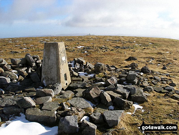 The summit of Cross Fell in The North Pennines
Photo: Ryan Pearson
# Whether you print a copy or download it to your phone, this Peak Baggers' Map will prove incredibly useful if you want to know what's what when you are up in the mountains and cannot get a phone signal.
Is there a Mountain, Peak, Top or Hill missing from the above google map or list?


