
![]()
Meldon Hill (Dufton Fell)
767m (2517ft)
The North Pennines, Cumbria, England
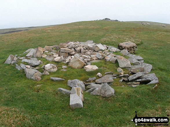
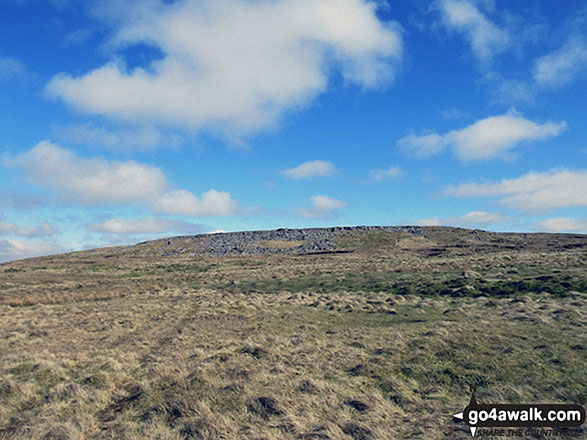
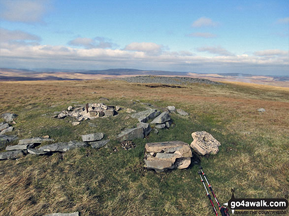
The summit of Meldon Hill (Dufton Fell) is marked by an Ordnance Survey Trig Point.
Not familiar with this top?
   |
|---|
Vital Statistics:
| Length: | 15.75ml (23.5km) |
|---|---|
| Ascent: | 1,835ft (559m) |
| Time: | 7.25hrs |
| Grade: |  (Hard) (Hard) |
Route Summary:
Cow Green Reservoir - Widdybank Fell - Cauldron Snout - The Pennine Way - Birkdale Farm - Grain Beck - Rasp Hill - Maize Beck - High Cup - High Cup Nick - Stake Beck - Meldon Hill (Dufton Fell) - Force Burn - River Tees - Backside Fell Bothy - Cow Green Reservoir
See Meldon Hill (Dufton Fell) and the surrounding tops on our free-to-access 'Google Style' Peak Bagging Map:
The North Pennines
Less data - quicker to download
See Meldon Hill (Dufton Fell) and the surrounding tops on our downloadable Peak Bagging Map in PDF format:

NB: Whether you print off a copy or download it to your phone, this PDF Peak Baggers' Map might prove incredibly useful when your are up there on the tops and you cannot get a phone signal.
You can find Meldon Hill (Dufton Fell) & all the walks that climb it on these unique free-to-access Interactive Walk Planning Maps:
1:25,000 scale OS Explorer Maps (orange/yellow covers):
1:50,000 scale OS Landranger Map (pink/magenta covers):
 Fellow go4awalkers who have already walked, climbed, summited & bagged Meldon Hill (Dufton Fell)
Caroline Winter walked up Meldon Hill (Dufton Fell) on July 19th, 2022 [from/via/route] Cow Green reservoir car park, route via Cauldron Snout & Birkdale Farm [with] Solo [weather] Hottest recorded day - 37 degrees in Middleton in Teesdale - Ventured as far north as I could drive to get away from blistering heat of 40 degrees at home. Tarmac track all the way to the farm (most remote in England)did not help in the heat, & already short on water before climbing Meldon hill. The farmer, allowed my access, even though it was closed today & he suggested I check on the Crows act, before walking in the Pennines in future. He watched my progress to the top. I sent him a few jars of our honey to thank him. He directed me to the shooters hut & then take a track to the right of the hut,to make way to the top of the shooters tracks. Unfortunately, the turn off to the right is not obvious, so I found myself on a faint route up the dried peaty hillside, & it was hard going. Broken trig at the top. Plunged into Cauldron snout on return & gulped down 2 litres of peaty river water.
Mark Davidson climbed Meldon Hill (Dufton Fell) on June 2nd, 2008 [from/via/route] Walk du144 High Cup Nick & Meldon Hill from Cow Green Reservoir [with] Alone [weather] High white cloud - tops were clear
Kevin Foster bagged Meldon Hill (Dufton Fell) on April 30th, 2018 [from/via/route] Knock Fell [with] Henry [weather] Sunny with partial cloud (cold breeze at times) - I started this next section of the walk with some trepidation. The guide book talked about 3 miles of pathless walking along the broad ridge linking Knock Fell to Meldon Hill. But the weather was glorious, I had many hours of daylight remaining & no problems with route finding...or so I thought. The walk started easy enough over grass but got progressively worse & worse. The peat hags became more & more frequent & were the only route finding problem in the end. I would definitely not recommend this route in anything other than dry conditions & clear visibility. Eventually, Meldon Hill got closer & the terrain became firmer under foot as limestone started to appear again. The summit was certainly worth the effort it took to get there. The views all round but especially in the direction of Cow Green reservoir were fantastic. Also, the full length side view of Mickle Fell. The descent was a further two miles of very rough walking through heather & bog but eventually I reached Maize Beck & was able to cross it dry shod before realising I'd overshot the foot bridge by only a couple of hundred yards. After half a mile of delightful walking on grass I reached the wonder that is High Cup Nick, a stunning example of a glaciated valley. the walk along the western rim looking down into the depths & the walk back to Dufton along The Pennine Way in glorious late afternoon sunshine will remain a memory for a long time. A very tough but ultimately satisfying walk.
Darren Mortimer hiked Meldon Hill (Dufton Fell) on April 21st, 2018 [from/via/route] Murton [with] Dermot Palmer [weather] Sunny warm & overcast at times - This walk is best done from the Pennine way & up Rasp Hill in a straight line following the grouse butts. The trig point isn't intact any more which is a shame.
Christine Shepherd summited Meldon Hill (Dufton Fell) on April 7th, 2017 [from/via/route] Walked from Dufton using part of walk du 144 [with] On my own [weather] Dull but clear enough for good views. - Got a bit disoriented in the peat hags. Easier coming down as I just headed for High Cup Nick. This fell marks a milestone as it was my 500th fell since I started logging them in 2005
Ray O'hara conquered Meldon Hill on June 26th, 2013 [from/via/route] Tagged onto the end of walk C419, walked up from High Cup Nick [weather] Fine & warm - Once off the beaten track it's a slog across unpleasant ground
Patrick Rogozinski and Trevor Williams have both walked, climbed & bagged Meldon Hill.
To add (or remove) your name and experiences on this page - Log On and edit your Personal Mountain Bagging Record
More Photographs & Pictures of views from, on or of Meldon Hill (Dufton Fell)
Send us your photographs and pictures on, of, or from Meldon Hill (Dufton Fell)
If you would like to add your walk photographs and pictures featuring views from, on or of Meldon Hill (Dufton Fell) to this page, please send them as email attachments (configured for any computer) along with your name to:
and we shall do our best to publish them.
(Guide Resolution = 300dpi. At least = 660pixels (wide) x 440 pixels (high).)

You can also submit photos via our Facebook Page.
NB. Please indicate where each photo was taken and whether you wish us to credit your photos with a Username or your First Name/Last Name.
Not familiar with this top?


