UK Postcode PE3 - The 30 nearest easy-to-follow, circular walk route maps to you
The thirty nearest easy-to-follow, circular walk route maps to you in UK Postcode PE3 in Walk Grade Order
The UK cities, towns and villages in Cambridgeshire, England that have PE3 in their UK Postcode include:
• Longthorpe •
Not familiar with the area around PE3?
See these 30 nearest walks to UK Postcode PE3 on a google map
   |
Vital Statistics:
| Length: | 7.25 miles (11.5 km) |
| Ascent: | 515ft (157m) |
| Time: | 3 hrs |
| Grade: |  |
|
Vital Statistics:
| Length: | 4.5 miles (7 km) |
| Ascent: | 295ft (90m) |
| Time: | 2 hrs |
| Grade: |  |
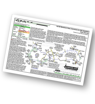
Route Summary:
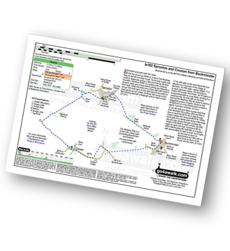
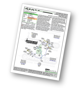
Little Gransden - Waresley - Waresley Wood - Waresley Dean Brook - Gransden Wood - Squirrels' Grove - Gransden Park - Great Gransden - Home Dole Brook - Little Gransden
|
Vital Statistics:
| Length: | 8.5 miles (13.5 km) |
| Ascent: | 246ft (75m) |
| Time: | 3½ hrs |
| Grade: | |
|
Vital Statistics:
| Length: | 6.5 miles (10 km) |
| Ascent: | 328ft (100m) |
| Time: | 2½ hrs |
| Grade: | |
Route Summary:
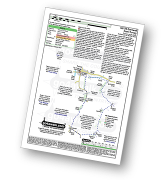
Turvey - Turvey Abbey - Priory Farm - Grotto Plantation - Hill Spinney - Ramacre Wood - Gorewell - The Milton Keynes Boundary Walk - Gullet Wood - Keepers (Church's) Cottage - Woodside - Turvey
|
Vital Statistics:
| Length: | 6.5 miles (10 km) |
| Ascent: | 82ft (25m) |
| Time: | 2½ hrs |
| Grade: |  |
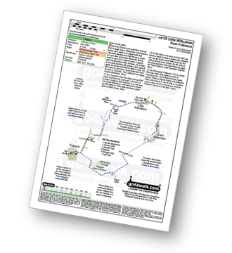
Route Summary:
Fulbourn - Harcamlow Way - Cole's Bridge - New Cut Drain - Hawk Mill Farm - Little Wilbraham - Great Wilbraham - Fleam Dyke - Fulbourn
|
Vital Statistics:
| Length: | 5.25 miles (8.5 km) |
| Ascent: | 292ft (89m) |
| Time: | 2.25hrs |
| Grade: | |
|
Vital Statistics:
| Length: | 6.5 miles (10.5 km) |
| Ascent: | 338ft (103m) |
| Time: | 2.75hrs |
| Grade: | |
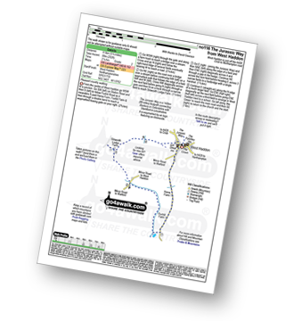
Route Summary:
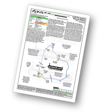
West Haddon - Foxhill Farm - Watford - The Jurassic Way - Barleypiece Spinney - Long Spinney - Flavell's Lodge - Silsworth Lodge Farm - West Haddon
|
Vital Statistics:
| Length: | 5 miles (8 km) |
| Ascent: | 345ft (105m) |
| Time: | 2.25hrs |
| Grade: | |
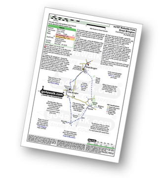
Route Summary:
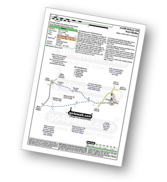
Great Brington - Nobottle Wood - The Midshires Way - Nobottle - The Macmillan Way - Little Brington - Great Brington
|
Vital Statistics:
| Length: | 5.75 miles (9 km) |
| Ascent: | 226ft (69m) |
| Time: | 2½ hrs |
| Grade: | |
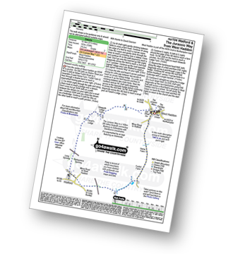
Route Summary:
Watford - The Jurassic Way - Barleypiece Spinney - Long Spinney - Watford Covert - Flavell's Lodge - Silsworth Lodge Farm - Cherry Lodge - Watford
|
Vital Statistics:
| Length: | 8.75 miles (14 km) |
| Ascent: | 36ft (11m) |
| Time: | 3 hrs |
| Grade: | |
Route Summary:
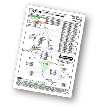
Bardney - Bardney Abbey - Young Wood - Southrey Wood - Tupholme Abbey - Southrey - The Viking Way - Bardney
|
Vital Statistics:
| Length: | 5.5 miles (9 km) |
| Ascent: | 499ft (152m) |
| Time: | 2½ hrs |
| Grade: | |
|
Vital Statistics:
| Length: | 7 miles (11 km) |
| Ascent: | 771ft (235m) |
| Time: | 3.25hrs |
| Grade: |  |
Route Summary:
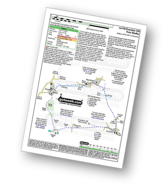
Badby - Knightley Way - Badby Wood - Badby Down - Fawsley Hall - Everdon Hill - Everdon - Little Everdon - The Nene Way - River Nene - Newnham - Badby
|
Vital Statistics:
| Length: | 6.25 miles (70 km) |
| Ascent: | 240ft (73m) |
| Time: | 2½ hrs |
| Grade: | |

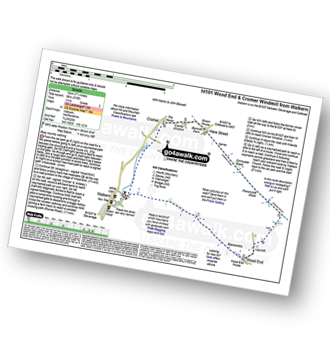
Route Summary:
Ardeley - Wood End - Roman Road - Hare Street - Roman Road - Hare Street - Cromer Windmill - Ardeley
|
Vital Statistics:
| Length: | 4.75 miles (7.5 km) |
| Ascent: | 249ft (76m) |
| Time: | 2 hrs |
| Grade: | |

|
Vital Statistics:
| Length: | 7.5 miles (12 km) |
| Ascent: | 315ft (96m) |
| Time: | 3 hrs |
| Grade: | |
Not familiar with the area around PE3?
See these 30 nearest walks to UK Postcode PE3 on a google map
|
Vital Statistics:
| Length: | 2.25 miles (3.5 km) |
| Ascent: | 72ft (22m) |
| Time: | 1 hrs |
| Grade: | |
|
Vital Statistics:
| Length: | 6.5 miles (10.5 km) |
| Ascent: | 637ft (194m) |
| Time: | 3 hrs |
| Grade: | |
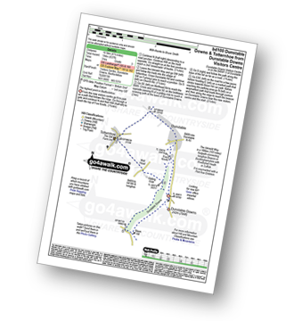
Route Summary:
Dunstable Downs Visitors Centre - The Icknield Way - Five Knolls - Drovers Way - Totternhoe - Well Head - Bison Hill - Dunstable Downs Visitors Centre
|
Vital Statistics:
| Length: | 6.5 miles (10 km) |
| Ascent: | 722ft (220m) |
| Time: | 3 hrs |
| Grade: | |
Route Summary:
Dagnall - Chlitern Farm - Former Radio Station - Gallows Hill - Ivinghoe Beacon - The Ridgeway - Ivinghoe Hills - Steps Hill - Down Farm - Clipperdown Cottage - Clipper Down - Ward's Hurst Farm - Hog Hall - Hog Hall Lane - Dagnall
|
Vital Statistics:
| Length: | 9 miles (14.5 km) |
| Ascent: | 256ft (78m) |
| Time: | 3.75hrs |
| Grade: | |
Route Summary:
Takeley - Hope End Green - Cow Common - Hellman's Cross - Taverners Green - Hatfield Broad Oak - Three Forests Way - Pincy Brook - Bush End - Harcamlow Way - The Flitch Way - Takeley
|
Vital Statistics:
| Length: | 3.5 miles (5.5 km) |
| Ascent: | 289ft (88m) |
| Time: | 1.75hrs |
| Grade: | |
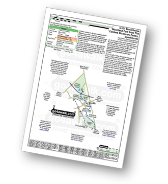
Route Summary:
Conkers Discovery Centre - Swadlincote - Conkers Waterside - Ashby Woulds Heritage Trail - Donisthorpe - Donisthorpe Woodland Park - Ashby De La Zouch Canal - Moira Lock - Moira Furnace Museum - Moira - Sarah's Wood - Conkers Waterside - Conkers Discovery Centre - Swadlincote.
|
Vital Statistics:
| Length: | 7.75 miles (12.5 km) |
| Ascent: | 295ft (90m) |
| Time: | 3.25hrs |
| Grade: | |

|
Vital Statistics:
| Length: | 6.75 miles (10 km) |
| Ascent: | 256ft (78m) |
| Time: | 2.75hrs |
| Grade: | |
|
Vital Statistics:
| Length: | 4.5 miles (7 km) |
| Ascent: | 407ft (124m) |
| Time: | 2 hrs |
| Grade: | |
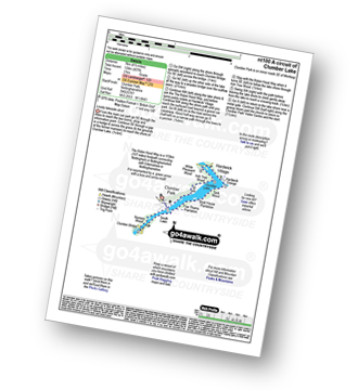
Route Summary:
Clumber Park - Clumber Lake - Nursery Wood - Clumber Bridge - South Lawn - Five Thorns Plantation - Boat House Plantation - Tank Wood - Hardwick Grange - Hardwick Village - White Pleasant Wood - Ash Tree Wood - Clumber Park
|
Vital Statistics:
| Length: | 5.25 miles (8.5 km) |
| Ascent: | 177ft (54m) |
| Time: | 2.25hrs |
| Grade: | |
Route Summary:
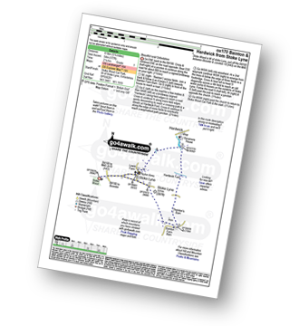
Stoke Wood - Stoke Lyne - Bainton - Hardwick Ford - Hardwick - Stoke Bushes - Stoke Lyne - Stoke Wood
|
Vital Statistics:
| Length: | 6.5 miles (10.5 km) |
| Ascent: | 230ft (70m) |
| Time: | 2½ hrs |
| Grade: | |
Route Summary:
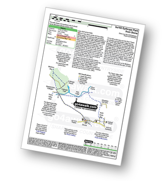
Stone - Hartwell Church - Upper Hartwell - Whaddon Hill Farm - The North Bucks Way - River Thame - Thame Valley Walk - The Midshires Way - Weir Lodge - Bridge Lodge - Eythrope Park - Beachendon Cottages - Eythrope House - Aylesbury Ring - Stone
|
Vital Statistics:
| Length: | 9 miles (14.5 km) |
| Ascent: | 328ft (100m) |
| Time: | 3½ hrs |
| Grade: | |
Route Summary:
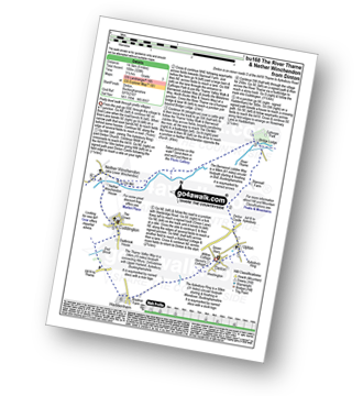
Dinton - Upton - The Aylsebury Ring - Dinton Castle - Starveall Farm - Eythrope Park - The Midshires Way - The North Bucks Way - The Swans Way - Bridge Lodge - The River Thame - The Bernwood Jubilee Way - The Thame Valley Way - Nether Winchendon - Lower Winchendon - Cuddington - Haddenham - Dad Brook - Townsend - Haddenham - Westington - Dinton
|
Vital Statistics:
| Length: | 5.5 miles (9 km) |
| Ascent: | 853ft (260m) |
| Time: | 3 hrs |
| Grade: | |
Route Summary:
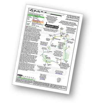
Butler's Cross - Monument Hill (Coombe Hill) - The Ridgeway - Linton's Wood - Goodmerhill Wood - Chisley Wood - The Icknield Way - Chequers - Pond Wood - Pulpit Wood - The North Bucks Way - The Midshires Way - Chequers Knap - Whorley Wood - Ellesborough Warren - Boxtree Wood - Beacon Hill (Ellesborough) - Ellesborough - The Aylesbury Ring - Springs Farm - Butler's Cross
|
Vital Statistics:
| Length: | 4.75 miles (7.5 km) |
| Ascent: | 476ft (145m) |
| Time: | 2.25hrs |
| Grade: | |
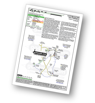
Route Summary:
Piddington - Muswell Hill - Oakcroft Farm - Little Wood - Piddington Wood - Widnell Park - Piddington
|
Vital Statistics:
| Length: | 7.5 miles (12 km) |
| Ascent: | 252ft (77m) |
| Time: | 3 hrs |
| Grade: | |
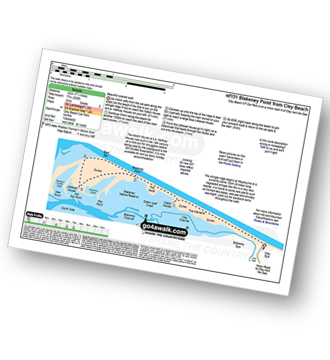
Route Summary:
Cley Beach Car Park - The Marrams - Watch House (Halfway House) - The Hood - Blakeney Point - Lifeboat House - East Bar - Blakeney Point - The Hood - Watch House (Halfway House) - The Marrams - Cley Beach Car Park
|
Vital Statistics:
| Length: | 8.25 miles (13 km) |
| Ascent: | 919ft (280m) |
| Time: | 4 hrs |
| Grade: | |
Route Summary:
The Lee - Kiln Cottage - Lee Gate - The Chiltern Way - Durham Farm - Wendoverdean Farm - Wendover Dean - Mayortorne Manor - Russell Farm - Dunsmore - Scrub Wood - Hampdenleaf Wood - The Icknield Way - Little Hampden Common - Little Hampden - The South Bucks Way - Cobblershill Farm - The Chiltern Way - Cockshoots Wood - Mayortorne Manor - Spinney Cottage - The Lee
Not familiar with the area around PE3?
See these 30 nearest walks to UK Postcode PE3 on a google map


