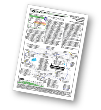
Reach Your Peak in Snowdonia with
 &
&

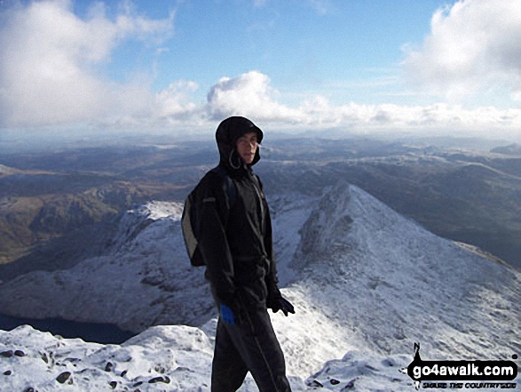
My Boyfriend, Oli Booth on Snowdon,
overlooking the Crib Goch ridge
Snowdonia Gwynedd Wales
"We climbed Snowdon in the snow in January this year. It was well worth it!" – Sarah Barley
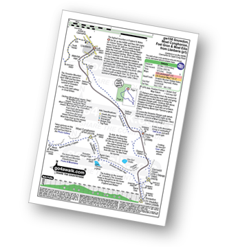
See views like this by using any of these 12 easy-to-follow circular walk route maps:
   |
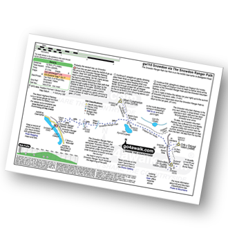
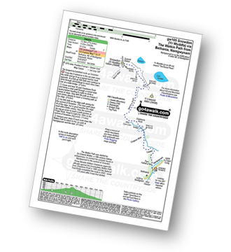
Vital Statistics:
| Length: | 7.5 miles (12 km) |
| Ascent: | 3,034ft (925m) |
| Time: | 6 hrs |
| Grade: |  |
Route Summary:
Pen-y-Pass - Pyg Track - Bwlch y Moch - Craig Fach - Miners' Track - Snowdon Mountain Railway - Snowdon (Yr Wyddfa) - Miners' Track - Glaslyn - Llyn Llydaw - Pen-y-Pass
|
Vital Statistics:
| Length: | 7 miles (11 km) |
| Ascent: | 3,805ft (1,160m) |
| Time: | 6.25hrs |
| Grade: | |
Route Summary:
Pen-y-Pass - Pyg Track - Bwlch y Moch - Craig Fach - Crib Goch - Garnedd Ugain (Crib y Ddysgl) - Snowdon Mountain Railway - Snowdon (Yr Wyddfa) - The Scree Path - Bwlch y Saethau - Bwlch Ciliau - Y Lliwedd - Y Lliwedd (East Top) - Lliwedd Bach - Miners' Track - Pen-y-Pass
|
Vital Statistics:
| Length: | 6.5 miles (10.5 km) |
| Ascent: | 2,938ft (895m) |
| Time: | 5½ hrs |
| Grade: | |
Route Summary:
Pen-y-Pass - Pyg Track - Bwlch y Moch - Miners' Track - Snowdon Mountain Railway - Snowdon (Yr Wyddfa) - Miners' Track - Pyg Track - Bwlch y Moch - Pen-y-Pass
|
Vital Statistics:
| Length: | 7.75 miles (12.5 km) |
| Ascent: | 3,200ft (975m) |
| Time: | 6.25hrs |
| Grade: | |
Route Summary:
Snowdon Ranger Car Park - Snowdon Ranger Railway Station - Llwyn Onn - Maen Bras - Snowdon Ranger Path - Bwlch Cwm Brwynog - Clogwyn Du'r Arddu - Snowdon Mountain Railway - Snowdon (Yr Wyddfa) - Snowdon Ranger Path - Snowdon Ranger Car Park
|
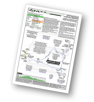
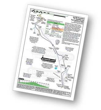
Vital Statistics:
| Length: | 8 miles (12 km) |
| Ascent: | 3,131ft (954m) |
| Time: | 7.75hrs |
| Grade: | |
Route Summary:
Rhyd-Ddu - The Rhyd-Ddu Path - Pen Ar Lon - Bwlch Main - Snowdon (Yr Wyddfa) - Bwlch Main - Llechog (Rhydd Ddu Path) - Pen Ar Lon - The Rhyd-Ddu Path - Rhyd-Ddu,.
|
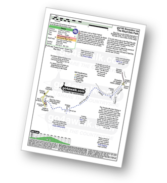
Vital Statistics:
| Length: | 9 miles (14.5 km) |
| Ascent: | 3,982ft (1,214m) |
| Time: | 7½ hrs |
| Grade: |  |
Route Summary:
Rhyd-Ddu - Rhyd-Ddu Path - Pen Ar Lon - Bwlch Main - Snowdon (Yr Wyddfa) - Allt Maenderyn - Bwlch Cwm Llan - Yr Aran - Pen Ar Lon - Rhyd-Ddu
|
Vital Statistics:
| Length: | 9.5 miles (14.5 km) |
| Ascent: | 4,517ft (1,377m) |
| Time: | 8 hrs |
| Grade: | |
Route Summary:
Nantgwynant - Bethania - Castell - Gladstone Rock - The Watkin Path - Bwlch Ciliau - Bwlch y Saethau - The Scree Path - Snowdon (Yr Wyddfa) - Rydd Ddu Path - Clogwyn Du - Allt Maenderyn - Yr Aran - Clogwyn Birth - Nantgwynant
|
Vital Statistics:
| Length: | 7.5 miles (12 km) |
| Ascent: | 4,100ft (1,250m) |
| Time: | 6½ hrs |
| Grade: | |
Route Summary:
Pen-y-Pass - Pyg Track - Bwlch y Moch - Craig Fach - Crib Goch - Garnedd Ugain (Crib y Ddysgl) - Snowdon Mountain Railway - Snowdon (Yr Wyddfa) - The Scree Path - Bwlch y Saethau - Bwlch Ciliau - Y Lliwedd - Y Lliwedd (East Top) - Lliwedd Bach - Gallt y Wenallt - Afon Glaslyn - Miners' Track - Pen-y-Pass
|
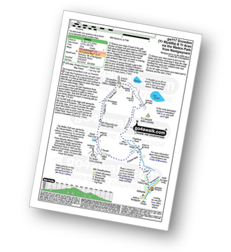
Vital Statistics:
| Length: | 7.75 miles (12.5 km) |
| Ascent: | 3,682ft (1,122m) |
| Time: | 6½ hrs |
| Grade: | |
Route Summary:
Nantgwynant - Bethania - Castell - Gladstone Rock - The Watkin Path - Bwlch Ciliau - Bwlch y Saethau - The Scree Path - Snowdon (Yr Wyddfa) - The Scree Path - Bwlch y Saethau - Bwlch Ciliau - The Watkin Path - Gladstone Rock - Castell - Bethania - Nantgwynant
|
Vital Statistics:
| Length: | 9 miles (14.5 km) |
| Ascent: | 3,344ft (1,019m) |
| Time: | 6.75hrs |
| Grade: | |
Route Summary:
Snowdon Mountain Railway Llanberis Station - Cader Ellyll - Llanberis Path - Halfway Station - Clogwyn Station - Bwlch Glas - Snowdon (Yr Wyddfa) - Bwlch Glas - Clogwyn Station - Halfway Station - Llanberis Path - Cader Ellyll - Llanberis.
|
Vital Statistics:
| Length: | 11.5 miles (18.5 km) |
| Ascent: | 4,179ft (1,346m) |
| Time: | 8.75hrs |
| Grade: |  |
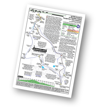
Route Summary:
Snowdon Mountain Railway Llanberis Station - Cader Ellyll - Llanberis Path - Halfway Station - Llechog (Llanberis Path) - Clogwyn Station - Garnedd Ugain (Crib y Ddysgl) - Bwlch Glas - Snowdon (Yr Wyddfa) - Clogwyn Du'r Arddu Path - Snowdon Ranger Path - Moel Cynghorion - Bwlch Maesgwm - Llanberis.
|
Vital Statistics:
| Length: | 13.25 miles (21 km) |
| Ascent: | 5,651ft (1,723m) |
| Time: | 10½ hrs |
| Grade: |  |
Route Summary:
Snowdon Mountain Railway Llanberis Station - Cader Ellyll - Llanberis Path - Halfway Station - Llechog (Llanberis Path) - Clogwyn Station - Garnedd Ugain (Crib y Ddysgl) - Bwlch Glas - Snowdon (Yr Wyddfa) - Clogwyn Du'r Arddu Path - Snowdon Ranger Path - Moel Cynghorion - Bwlch Maesgwm - Foel Goch (Snowdon) - Foel Gron - Moel Eilio (Llanberis) - Llanberis.
Send us your photographs and pictures of walks and hikes in the British countryside
If you would like to see your digital photographs as part of this collection, please send them as email attachments (configured for any computer) along with your name to:
and we shall do our best to publish them.
(Guide Resolution = 300dpi. At least = 587 pixels (wide) x 440 pixels (high).)

You can also submit photos via our Facebook Page.
NB. Please indicate where each photo was taken.
NB. To see photographs and pictures from a particular walk choose your walk from Walks or use our Walk Search facility.
To see photographs and pictures on, of or from a particular Mountain, Peak, Top or Hill select from Peaks & Mountains' or enter the Mountain, Peak, Top or Hill Name into our 'Photo Search facility.


