
![]()
Mardale Ill Bell
760m (2494ft)
The Far Eastern Fells, The Lake District, Cumbria, England
Not familiar with this top?
   |
|---|
Vital Statistics:
| Length: | 7.25ml (11.5km) |
|---|---|
| Ascent: | 2,745ft (837m) |
| Time: | 5½ hrs |
| Grade: |  (Hard) (Hard) |
Route Summary:
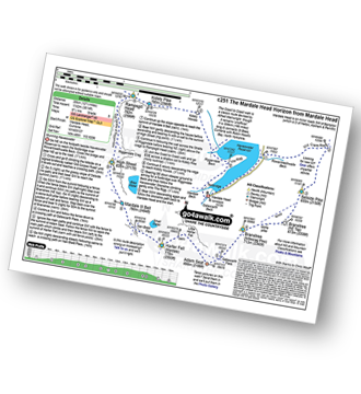
Mardale Head - Haweswater Reservoir - The Rigg - Dudderwick - Swine Crag (Riggindale) - Heron Crag (Riggindale) - Rough Crag (Riggindale) - Caspel Gate - Riggindale Crag - Long Stile - High Street - Mardale Ill Bell - Nan Bield Pass - Harter Fell (Mardale) - Adam Seat - Gatescarth Pass - Mardale Head
|
|---|
Vital Statistics:
| Length: | 11.25ml (18km) |
|---|---|
| Ascent: | 3,436ft (1,047m) |
| Time: | 7½ hrs |
| Grade: | (Hard) |
Route Summary:
Mardale Head - Haweswater Reservoir - Rowantreethwaite Beck - Old Corpse Road - Selside Pike - Branstree (North East Top) - Branstree (Artlecrag Pike) - Gatescarth Pass - Adam Seat - Harter Fell (Mardale) - Nan Bield Pass - Mardale Ill Bell - High Street - Riggindale Crag - Caspel Gate - Rough Crag (Riggindale) - Eagle Crag (Riggindale) - Heron Crag (Riggindale) - Swine Crag (Riggindale) - Dudderwick - The Rigg - Mardale Head
|
|---|
Vital Statistics:
| Length: | 11.5ml (18.5km) |
|---|---|
| Ascent: | 3,378ft (1,030m) |
| Time: | 7½ hrs |
| Grade: | (Hard) |
Route Summary:
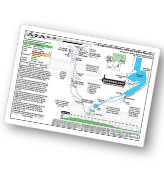
Kentmere - Garburn Pass - Yoke - Ill Bell - Froswick - Thornthwaite Crag - Mardale Ill Bell - Nan Bield Pass - Harter Fell (Mardale) - Kentmere Pike - Brookstones - Kentmere
|
|---|
Vital Statistics:
| Length: | 12.5ml (20km) |
|---|---|
| Ascent: | 3,814ft (1,162m) |
| Time: | 8½ hrs |
| Grade: |  (Hard) (Hard) |
Route Summary:
Mardale Head - Haweswater - Rowantreethwaite Beck - Old Corpse Road - Selside Pike - Branstree (North East Top) - Branstree (Artlecrag Pike) - Gatescarth Pass - Adam Seat - Harter Fell (Mardale) - Nan Bield Pass - Mardale Ill Bell - High Street - Riggindale - Rampsgill Head - Wainwright's Coast to Coast Walk - Kidsty Pike - Kidsty Howes - Bowderthaite Bridge - The Rigg - Mardale Head
|
|---|
Vital Statistics:
| Length: | 14.5ml (23km) |
|---|---|
| Ascent: | 3,364ft (1,025m) |
| Time: | 8½ hrs |
| Grade: | (Hard) |
Route Summary:
Mardale Head (Haweswater Reservoir) - Small Water - Nan Bield Pass - Mardale Ill Bell - High Street - Straits of Riggindale - The Knott - Rampsgill Head - Kidsty Pike - High Raise (Mardale) - Raven Howe - Red Crag - Keasgill Head - Wether Hill (South Top) - Wether Hill - Bampton Common - Low Kop - Measand Beck - Haweswater Reservoir - Wainwright's Coast to Coast Walk - Bowderthwaite Bridge - The Rigg - Mardale Head
See Mardale Ill Bell and the surrounding tops on our free-to-access 'Google Style' Peak Bagging Maps:
The Far Eastern Fells of The Lake District National Park
Less data - quicker to download
The Whole of The Lake District National Park
More data - might take a little longer to download
See Mardale Ill Bell and the surrounding tops on our downloadable Peak Bagging Maps in PDF format:

NB: Whether you print off a copy or download it to your phone, these PDF Peak Baggers' Maps might prove incredibly useful when your are up there on the tops and you cannot get a phone signal.
*This version is marked with the walk routes you need to follow to Walk all 214 Wainwrights in just 59 walks.
You can find Mardale Ill Bell & all the walks that climb it on these unique free-to-access Interactive Walk Planning Maps:
1:25,000 scale OS Explorer Maps (orange/yellow covers):
1:50,000 scale OS Landranger Map (pink/magenta covers):
 Fellow go4awalkers who have already walked, climbed, summited & bagged Mardale Ill Bell
Pete George walked up Mardale Ill Bell on September 27th, 2025 [from/via/route] Mardale [with] Roco [weather] Chilly & foggy on tops, pleasant down below
James Hughes climbed Mardale Ill Bell on September 18th, 2024 [from/via/route] c251 The Mardale Head Horizon from Mardale Head [weather] Beautiful clear warm day. - Walked in reverse. Climbed from Kidsty Pike. Tired after walk preceding day. Included Adam's Seat. Descent from Selside Pike boggy on Old Corpse Road. Poor expensive pint of Mary Jane at Haweswater Hotel.
Christine Shepherd bagged Mardale Ill Bell during August, 2004 [from/via/route] Kentmere [with] Rebecca and Will [weather] Dull & Damp with rain on the descent. - Visited the summit again with Garry & Jonathan on 8.2.08 from Mardale Head. Then on my own on 24.5.10 in glorious sunshine as part of the Mardale Head Horizon walk c251 & 24.2.11 with my daughter Hannah in very misty conditions from Kentmere. Bagged again with Jenny 07-09-2019. Did The Kentmere Horseshoe solo on 6.3.22.
Steve Cookson hiked Mardale Ill Bell on March 23rd, 2022 [with] Gillie [weather] Misty
Martyn Howarth summited Mardale Ill Bell on August 15th, 2023 [from/via/route] From Kentmere Institute, as part of the Kentmere Horseshoe. [with] Tilly Howarth. [weather] Gorgeous August day, after some dreadful weather the days before! - Tough 14.5 mile walk - 3600ft of ascent! Brilliant effort by 14 yr old Tilly!
Adrian Howard conquered Mardale Ill Bell on June 12th, 2023 [from/via/route] From Mardale Head - Small water - Nan Bield Pass - Mardale Ill Bell - High Street - Kidsty Pike - kidsty Howes - Mardale Head
Paul Macey scaled Mardale Ill Bell on July 24th, 2018 [from/via/route] From Brothers Water using walks c251 & c204
Angeline Grieveson walked up Mardale Ill Bell on December 3rd, 2022 [with] Dotty & Paul
Martyn Atherton climbed Mardale Ill Bell on June 18th, 2022 [from/via/route] c362 Selside Pike, Branstree (Artlecrag pike), Harter Fell (Mardale), Mardale III Bell, Rough Crag (Riggendale) & High Street [with] Self [weather] Very Sunny & Warm - Fantastic Route 7 hrs
Chris Faulkner bagged Mardale Ill Bell on March 13th, 2022 [from/via/route] Troutbeck [with] Michelle Chandler [weather] Bright & blustery. - Yoke with Ill Bell, Froswick & Thornthwaite Crag
To add (or remove) your name and experiences on this page - Log On and edit your Personal Mountain Bagging Record
. . . [see more walk reports]
More Photographs & Pictures of views from, on or of Mardale Ill Bell
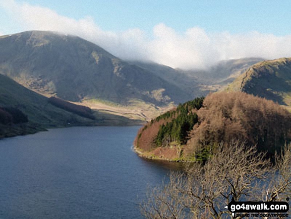
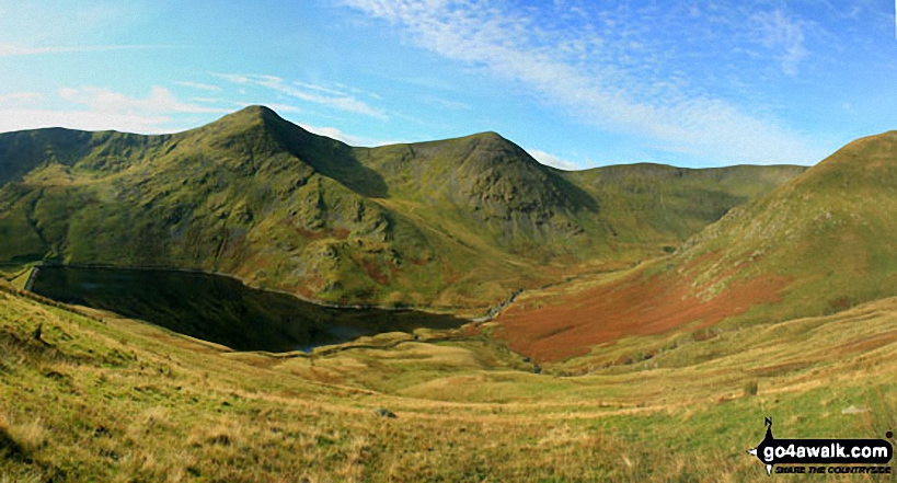
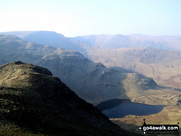
Harter Fell (left) and Mardale Ill Bell (in cloud) seen from above Haweswater Reservoir near Rowantreethwaite Beck
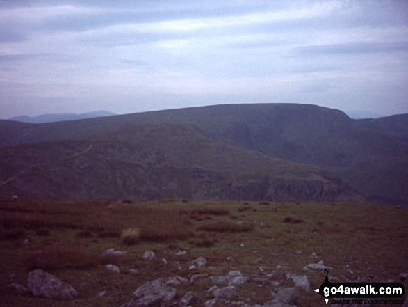
Yoke, Ill Bell, Froswick and the shoulder of Lingmell End (Mardale Ill Bell) above Kentmere Reservoir from Harter Fell (Mardale)
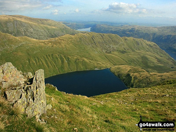
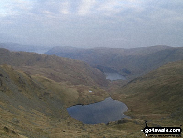
Rough Crag beyond Blea Water from above Blea Water Crag between High Street and Mardale Ill Bell
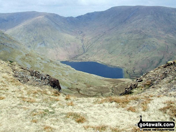
Mardale Ill Bell, High Street and Rough Crag (Riggindale) above Blea Tarn from Nan Bield Pass
Mardale Ill Bell (left) Nan Bield Pass and Harter Fell (Mardale)(right) with Kentmere Reservoir below from the summit of Yoke
Send us your photographs and pictures on, of, or from Mardale Ill Bell
If you would like to add your walk photographs and pictures featuring views from, on or of Mardale Ill Bell to this page, please send them as email attachments (configured for any computer) along with your name to:
and we shall do our best to publish them.
(Guide Resolution = 300dpi. At least = 660pixels (wide) x 440 pixels (high).)

You can also submit photos via our Facebook Page.
NB. Please indicate where each photo was taken and whether you wish us to credit your photos with a Username or your First Name/Last Name.
Not familiar with this top?


