
![]()
Kentmere Pike
730m (2396ft)
The Far Eastern Fells, The Lake District, Cumbria, England
The summit of Kentmere Pike is marked by an Ordnance Survey Trig Point.
Not familiar with this top?
You can walk/hike to the top of Kentmere Pike by using either of these 2 easy‑to‑follow route maps:
Walk c204 The Longsleddale Horizon from Stockdale
Superb mountain walk
   |
|---|
Vital Statistics:
| Length: | 10.5ml (17km) |
|---|---|
| Ascent: | 3,417ft (1,041m) |
| Time: | 7.25hrs |
| Grade: |  (Hard) (Hard) |

Route Summary:
Stockdale - Sadgill Bridge - Stockdale Beck - Great Howe - Grey Crag (Sleddale) - Tarn Crag (Sleddale) - Sleddale Fell - Selside Brow - Branstree (Artlecrag Pike) - Gatescarth Pass - Adam Seat - Harter Fell (Mardale) - Kentmere Pike - Goat Scar - Shipman Knotts - Wray Crag - Stockdale
Walk c257 The Kentmere Skyline from Kentmere
A classic lakeland horseshoe walk
|
|---|
Vital Statistics:
| Length: | 11.5ml (18.5km) |
|---|---|
| Ascent: | 3,378ft (1,030m) |
| Time: | 7½ hrs |
| Grade: | (Hard) |

Route Summary:
Kentmere - Garburn Pass - Yoke - Ill Bell - Froswick - Thornthwaite Crag - Mardale Ill Bell - Nan Bield Pass - Harter Fell (Mardale) - Kentmere Pike - Brookstones - Kentmere
See Kentmere Pike and the surrounding tops on our free-to-access 'Google Style' Peak Bagging Maps:
The Far Eastern Fells of The Lake District National Park
Less data - quicker to download
The Whole of The Lake District National Park
More data - might take a little longer to download
See Kentmere Pike and the surrounding tops on our unique, downloadable, PDF Peak Bagging Maps:

NB: Whether you print off a copy or download it to your phone, these PDF Peak Baggers' Maps might prove incredibly useful when your are up there on the tops and you cannot get a phone signal.
*This version is marked with the walk routes you need to follow to Walk all 214 Wainwrights in just 59 walks.
You can find Kentmere Pike & all the walks that climb it on these unique free-to-access Interactive Walk Planning Maps:
1:25,000 scale OS Explorer Map (orange/yellow covers):
1:50,000 scale OS Landranger Map (pink/magenta covers):
 Fellow go4awalkers who have already walked, climbed, scaled, summited, hiked & bagged Kentmere Pike
Tim Winn walked up Kentmere Pike on June 2nd, 2025 [from/via/route] Kentmere [with] Rachel and Helen [weather] Dry. Sunny.
Richard Holmes climbed it on April 8th, 2025 [from/via/route] Brockstones [with] Myself. [weather] Hot, not a cloud in the sky.
James Hughes bagged it on June 24th, 2024 [from/via/route] c204 The Longsleddale Horizon from Stockdale Bridge [weather] Beautiful warm sunny day - Very warm day with bad start hiking through Bracken.
Martyn Howarth hiked Kentmere Pike on August 15th, 2023 [from/via/route] From Kentmere Institute, as part of the Kentmere Horseshoe. [with] Tilly Howarth. [weather] Gorgeous August day, after some dreadful weather the days before! - Tough 14.5 mile walk - 3600ft of ascent! Brilliant effort by 14 yr old Tilly!
Christine Shepherd summited on March 15th, 2009 [from/via/route] I walked from Stockdale using walk c204 'The Longsleddale Horizon' [with] On my own [weather] Dry but rather overcast. - Climbed again using the same route in similar conditions on 16.7.20 Summitted Kentmere Pike again on 6.3.22 as part of The Kentmere Skyline. Finally did walk c204 in sunshine on 24.5.23 Such much easier when you can see the paths & the ground is dry.
To add (or remove) your name and experiences on this page - Log On and edit your Personal Mountain Bagging Record
. . . [see more walk reports]
More Photographs & Pictures of views from, on, or of, Kentmere Pike

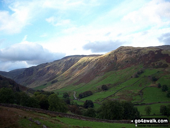
The Kentmere Horseshoe (Yoke, Ill Bell, Froswick, Thornthwaite Crag, Kentmere Pike and Shipman Knotts) from Hollow Moor
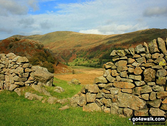

Harter Fell (Kentmere), Kentmere Pike and Shipman Knotts from Hall Wood in the Kentmere Valley
Send us your photographs and pictures on, of, or from Kentmere Pike
If you would like to add your walk photographs and pictures to this page, please send them as email attachments (configured for any computer) along with your name to:
and we shall do our best to publish them.
(Guide Resolution = 300dpi. At least = 660pixels (wide) x 440 pixels (high).)

You can also submit photos via our Facebook Page.
NB. Please indicate where each photo was taken and whether you wish us to credit your photos with a Username or your First Name/Last Name.


