
![]()
Pen Allt-mawr
719m (2362ft)
The Black Mountains, The Brecon Beacons, Powys, Wales
Tap/mouse over a coloured circle (1-3 easy walks, 4-6 moderate walks, 7-9 hard walks) and click to select.
The summit of Pen Allt-mawr is marked by an Ordnance Survey Trig Point.
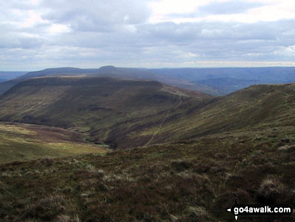
Pen Cerrig-calch, Pen Allt-mawr, Tal-Trwynau, Pen Twyn Glas, Mynydd Llysiau and Pen Trumau from Waun Fach
Not familiar with this top?
   |
|---|
Vital Statistics:
| Length: | 6.25ml (10km) |
|---|---|
| Ascent: | 1,879ft (573m) |
| Time: | 4.25hrs |
| Grade: |  (Moderate) (Moderate) |
Route Summary:
Neuadd-fawr - Llanbedr - Ty-Croes Farm - Table Mountain (Pen Cerrig-calch) - Trwyn Ysgwrfa - Pen Cerrig-calch - Pen Allt-mawr - Pen Twyn Glas - Tal Trwynau - Darren Fach - Neuadd-fawr.
|
|---|
Vital Statistics:
| Length: | 11ml (17.5km) |
|---|---|
| Ascent: | 2,430ft (741m) |
| Time: | 6½ hrs |
| Grade: |  (Moderate) (Moderate) |
Route Summary:
Nuadd-fawr - Llanbedr - Table Mountain (Pen Cerrig-calch) - Trwyn Ysgwrfa - Pen Cerrig-calch - Pen Allt-mawr - Pen Twyn Glas - Mynydd Llysiau - Tal-y-maes Bridge - Hermitage Bridge - Cwm Farm - Nuadd-fawr
|
|---|
Vital Statistics:
| Length: | 13.5ml (21.5km) |
|---|---|
| Ascent: | 3,175ft (968m) |
| Time: | 8 hrs |
| Grade: |  (Hard) (Hard) |
Route Summary:
Nuadd-fawr - Llanbedr - Table Mountain (Pen Cerrig-calch) - Trwyn Ysgwrfa - Pen Cerrig-calch - Pen Allt-mawr - Pen Twyn Glas - Mynydd Llysiau - Pen Trumau - Waun Fach - Pen y Gadair Fawr - Pen Twyn Mawr - Pen Gwyllt Meirch - Nantyrychain - Cwm Farm - Nuadd-fawr
See Pen Allt-mawr and the surrounding tops on our free-to-access 'Google Style' Peak Bagging Maps:
The Black Mountains Area of Bannau Brycheiniog (The Brecon Beacons National Park)
Less data - quicker to download
The Whole of Bannau Brycheiniog (The Brecon Beacons National Park)
More data - might take a little longer to download
See Pen Allt-mawr and the surrounding tops on our downloadable Peak Bagging Map in PDF format:

NB: Whether you print off a copy or download it to your phone, this PDF Peak Baggers' Map might prove incredibly useful when your are up there on the tops and you cannot get a phone signal.
You can find Pen Allt-mawr & all the walks that climb it on these unique free-to-access Interactive Walk Planning Maps:
1:25,000 scale OS Explorer Map (orange/yellow covers):
1:50,000 scale OS Landranger Map (pink/magenta covers):
 Fellow go4awalkers who have already walked, climbed, summited & bagged Pen Allt-mawr
Craig Barrell walked up Pen Allt-mawr on September 13th, 2025 [with] solo [weather] sunny
Melfyn Parry climbed Pen Allt-mawr on July 16th, 2024 [from/via/route] Followed go4awalk route PO153 - Pen Cerrig Calch & Waun Fach from Neuadd Fawr. Once on the ridge the walk is relatively easy, good paths. There are some areas that are quite boggy, so be prepared if following this route after lots of rain. The first peak was hard going, lots of tall bracken & bilberry bushes to fight your way through, I was so glad to reach the top of Pen Cerrig Calch. The final path from the cairn to the minor road leading back to the car park was also overgrown with bracken & the public footpath part was seriously neglected from a maintenance perspective, although the stiles looked almost new the path itself was overgrown with nettle, bramble & even more bracken making the last leg of the walk hard work. [with] On my own [weather] Sunny spells & generally dry. For a mid July walk it was quite cool at times. - Best to avoid this walk when the bracken is in season. If you have to walk in the summer months & especially after rain, waterproofs are a must as the grasses & bracken don't dry out at their base & you can get seriously wet even though you think it's a dry day.
Paul Roddam bagged Pen Allt-mawr on April 14th, 2024 [from/via/route] Hairpin up from LLanbedr [with] solo [weather] Spring sun
Jonathan Morris hiked Pen Allt-mawr on February 17th, 2024 [from/via/route] Llanthony Priory [with] Mi Madre [weather] Wet & Windy
Donovan Suddell summited Pen Allt-mawr on May 8th, 2023 [from/via/route] Crickhowell [with] Wife [weather] warm but cloudy most of the day
Mark Davidson conquered Pen Allt-mawr on April 10th, 2005 [from/via/route] Walk po153 Pen Cerrig-calch & Waun Fach from Nuadd-fawr [with] Theresa [weather] Dry but rather cloudy - tops were clear though
Sion Britton scaled Pen Allt-mawr on April 11th, 2021 [from/via/route] O O Llanbedr. Horseshoe Route. [with] Solo [weather] Braf/ Cymylog
Mary Norris walked up Pen Allt-mawr on September 27th, 2020 [from/via/route] From Crickhowell via Table Mountain . [with] Betsie and WYWS [weather] Beautiful sunny day, really warm. - Beautiful clear views.
Simon Burgess climbed Pen Allt-mawr on August 23rd, 2020 [from/via/route] Pen Cerrig-Calch, Pen Allt Mawr, Pen Twyn Glas [with] Solo [weather] Everything in one day
Dale Tyler bagged Pen Allt-mawr on August 30th, 2017 [from/via/route] 2nd peak on the Waun Fach horseshoe from Cwmdu to Crickhowell [weather] Mostly glorious, two short sharp showers at the beginning of the walk-enough convince me to reproof my jacket! - 19 mile walk followed by a well deserved pint & meal in Crickhowell. Sticky toffee pudding, mmmmm!
To add (or remove) your name and experiences on this page - Log On and edit your Personal Mountain Bagging Record
. . . [see more walk reports]
Send us your photographs and pictures on, of, or from Pen Allt-mawr
If you would like to add your walk photographs and pictures featuring views from, on or of Pen Allt-mawr to this page, please send them as email attachments (configured for any computer) along with your name to:
and we shall do our best to publish them.
(Guide Resolution = 300dpi. At least = 660pixels (wide) x 440 pixels (high).)

You can also submit photos via our Facebook Page.
NB. Please indicate where each photo was taken and whether you wish us to credit your photos with a Username or your First Name/Last Name.
Not familiar with this top?


