UK Postcode CW3 - The 30 nearest easy-to-follow, circular walk route maps to you
The thirty nearest easy-to-follow, circular walk route maps to you in UK Postcode CW3 in Walk Grade Order
The UK cities, towns and villages in Cheshire, England that have CW3 in their UK Postcode include:
• Audlem • Betley • Buerton • Coxbank • Hankelow • Lightwood Green • Madeley • Madeley Heath • Onneley • Swanbach • Woore • Wrinehill •
Not familiar with the area around CW3?
See these 30 nearest walks to UK Postcode CW3 on a google map
   |
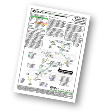
Vital Statistics:
| Length: | 8.25 miles (13 km) |
| Ascent: | 295ft (90m) |
| Time: | 3½ hrs |
| Grade: |  |
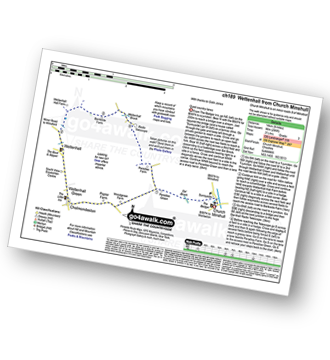
Route Summary:
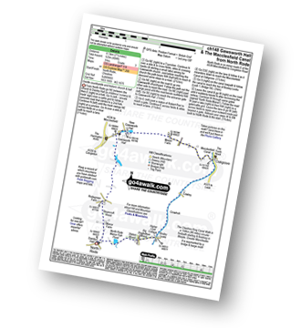
Church Minshull - Sunnyside - Eel Brook - Paradise Green - Paradise Wood - Wettenhall Green - Wettenhall - Stockerlane - Bankside Farm - Brookside Wood - Wettenhall Brook - Darnall Radio Telescope - Paradise Farm - Paradise Green - Eel Brook - Sunnyside - Church Minshull
|
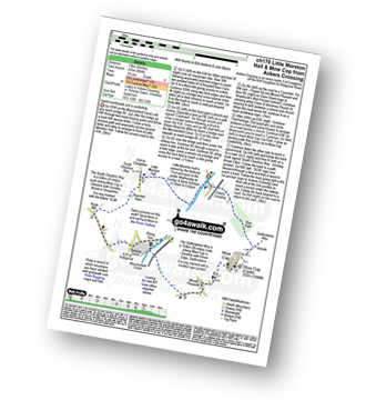
Vital Statistics:
| Length: | 5.5 miles (9 km) |
| Ascent: | 115ft (35m) |
| Time: | 2.25hrs |
| Grade: |  |
Route Summary:
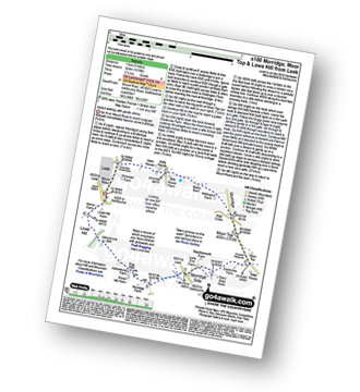
Ackers Crossing - The Macclesfield Canal - The Cheshire Ring Canal Walk - Little Moreton Hall - Boarded Barn Farm - Rode Mill - Claphatches - Scholar Green - The Macclesfield Canal - Ackers Crossing
|
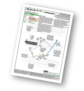
Vital Statistics:
| Length: | 5.5 miles (9 km) |
| Ascent: | 689ft (215m) |
| Time: | 2.75hrs |
| Grade: | |
Route Summary:
Ackers Crossing - The Macclesfield Canal - The Cheshire Ring Canal Walk - Scholar Green - Mount Pleasant - Mow Cop (Old Man of Mow) - The Gritstone Trail - The Staffordshire Way - The South Cheshire Way - Quarry Wood - Hanging Wood - Roe Park - Ackers Crossing
|
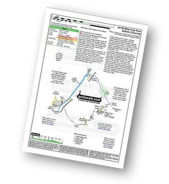
Vital Statistics:
| Length: | 8.25 miles (13 km) |
| Ascent: | 804ft (245m) |
| Time: | 3.75hrs |
| Grade: |  |
Route Summary:
Ackers Crossing - The Macclesfield Canal - The Cheshire Ring Canal Walk - Little Moreton Hall - Boarded Barn Farm - Rode Mill - Claphatches - Scholar Green - Mount Pleasant - Mow Cop (Old Man of Mow) - The Gritstone Trail - The Staffordshire Way - The South Cheshire Way - Quarry Wood - Hanging Wood - Roe Park - Ackers Crossing
|
Vital Statistics:
| Length: | 5 miles (8 km) |
| Ascent: | 542ft (165m) |
| Time: | 2½ hrs |
| Grade: | |
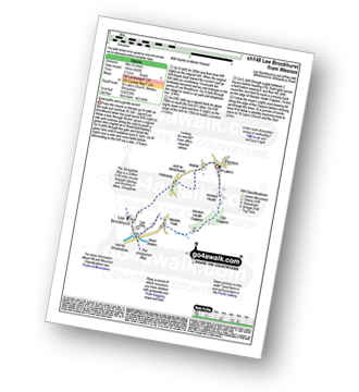
Route Summary:
Weston - Wixhill - Lee Brockhurst - The Shropshire Way - Weston Heath Coppice - Weston Heath - Weston
|
Vital Statistics:
| Length: | 3.5 miles (5.5 km) |
| Ascent: | 286ft (87m) |
| Time: | 1.75hrs |
| Grade: |  |
Route Summary:
Tiverton - The Shropshire Union Canal - Wharton's Lock - The Sandstone Trail - Beeston Castle - Beeston - Beeston Hall Farm - Tiverton
|
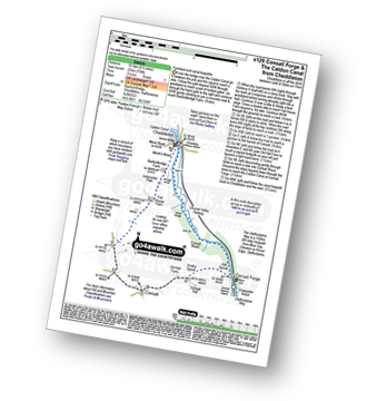
Vital Statistics:
| Length: | 4.75 miles (7.5 km) |
| Ascent: | 515ft (157m) |
| Time: | 2.25hrs |
| Grade: | |
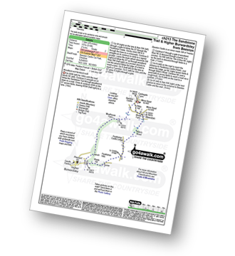
Route Summary:
Beeston - Beeston Castle - The Sandstone Trail - Peckforton Woods - Higher Burwardsley - Waste Hill - Peckforton Hills - Peckforton Castle Lodge - Willis's Wood - Beeston
|
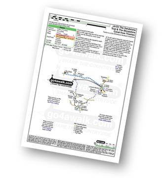
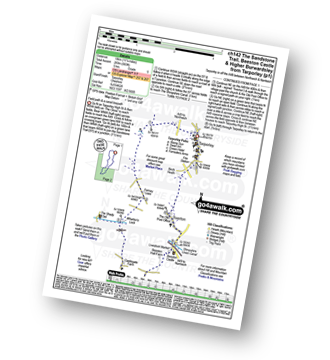
Vital Statistics:
| Length: | 9.5 miles (15 km) |
| Ascent: | 1,831ft (558m) |
| Time: | 5.25hrs |
| Grade: |  |
Route Summary:
Higher Burwardsley - The Sandstone Trail - Bulkeley Hill - Raw Head (Rawhead) - Chiflik Farm - Gallantry Bank - Bickerton - Bickerton Hill - Maiden Castle (Bickerton Hill) - Brown Knowl - Fullers Moor - Harthill - Burwardsley - Higher Burwardsley
|
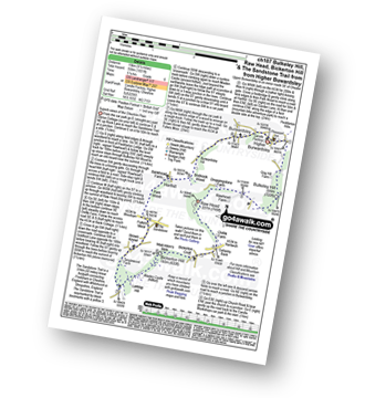
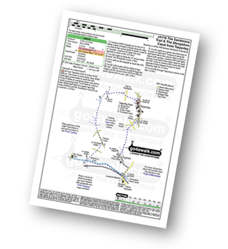
Vital Statistics:
| Length: | 5.5 miles (8.5 km) |
| Ascent: | 1,050ft (320m) |
| Time: | 3 hrs |
| Grade: | |
Route Summary:
Higher Burwardsley - The Sandstone Trail - Bulkeley Hill - Raw Head (Rawhead) - Bodnook Wood - Burwardsley Hill - Burwardsley - Higher Burwardsley
|
Vital Statistics:
| Length: | 9 miles (14.5 km) |
| Ascent: | 1,208ft (368m) |
| Time: | 4½ hrs |
| Grade: |  |
Route Summary:
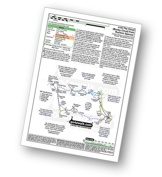
Timbersbrook - The Gritstone Trail - Pool Bank - The Staffordshire Way - Folly Cottage - Cloud Plantation - The Cloud (Bosley Cloud) - Avona - The Dane Valley Way - River Dane - The Macclesfield Canal - The Cheshire Ring Canal Walk - Buglawton - Brook House Farm - Pool Bank - Timbersbrook
|
Vital Statistics:
| Length: | 4 miles (6.5 km) |
| Ascent: | 791ft (241m) |
| Time: | 2.25hrs |
| Grade: | |
Route Summary:
Timbersbrook - The Gritstone Trail - Pool Bank - The Staffordshire Way - Folly Cottage - Cloud Plantation - The Cloud (Bosley Cloud) - Avona - Cloud Side Farm - Bridgestones Farm - Bridestones Burial Chamber - Timbersbrook
|
Vital Statistics:
| Length: | 7.5 miles (12 km) |
| Ascent: | 1,359ft (414m) |
| Time: | 4.25hrs |
| Grade: | |
Route Summary:
Timbersbrook - The Gritstone Trail - Pool Bank - The Staffordshire Way - Folly Cottage - Cloud Plantation - The Cloud (Bosley Cloud) - Avona - The Dane Valley Way - Raven's Clough - Ravensclough Brook - Rushton Spencer - Oulton - Woodhouse Green - Bridgestones Farm - Bridestones Burial Chamber - Timbersbrook
|
Vital Statistics:
| Length: | 6.5 miles (10.5 km) |
| Ascent: | 6ft (421m) |
| Time: | 2.75hrs |
| Grade: | |
Route Summary:
Duckington - Bickerton Hill - Brown Knowl - Fullers Moor - Harthill - Bodnook Wood - Droppingstone Farm - The Sandstone Trail - Raw Head (Rawhead) - Chiflik Farm - Gallantry Bank - Bickerton - Bickerton Hill - Maiden Castle (Bickerton Hill) - Duckington
|
Vital Statistics:
| Length: | 11.25 miles (18 km) |
| Ascent: | 883ft (269m) |
| Time: | 5 hrs |
| Grade: | |
Route Summary:
Tarpoley - The Sandstone Trail - Ferney Lees - Wharton's Bridge - The Shorpshire Union Canal - Wharton's Lock - Beeston Castle - Beeston - Peckforton Woods - Higher Burwardsley - Waste Hill - Peckforton Hills - Peckforton Castle Lodge - Willis's Wood - Beeston - A49 - Tiverton - Tarpoley
|
Vital Statistics:
| Length: | 6 miles (9.5 km) |
| Ascent: | 295ft (90m) |
| Time: | 2½ hrs |
| Grade: | |
Route Summary:
Tarpoley - The Sandstone Trail - Ferney Lees - Wharton's Bridge - The Shorpshire Union Canal - Wharton's Lock - A49 - Tiverton - Tarpoley
Not familiar with the area around CW3?
See these 30 nearest walks to UK Postcode CW3 on a google map
|
Vital Statistics:
| Length: | 6.5 miles (10.5 km) |
| Ascent: | 738ft (225m) |
| Time: | 3.25hrs |
| Grade: | |
Route Summary:
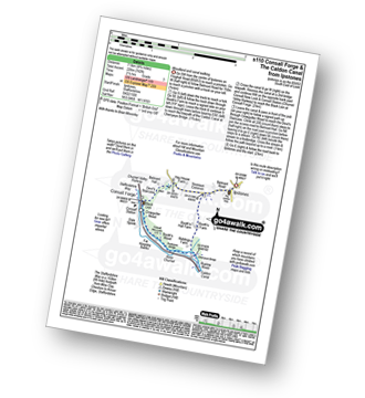
Cheddleton - Basford Bridge - Monk's Wood - Basfordbridge Farm - Felt House Farm - Consall - Consall Forge - River Churnet - Churnet Valley Railway - Caldon Canal - The Staffordshire Way - Consall Wood - Cheddleton
|
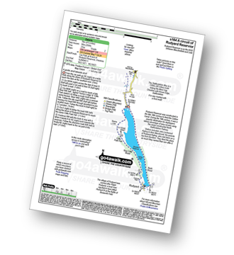
Vital Statistics:
| Length: | 10 miles (16 km) |
| Ascent: | 1,404ft (428m) |
| Time: | 5 hrs |
| Grade: | |
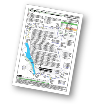
Route Summary:
Rudyard Reservoir - The Staffordshire Way - Ryecroft Gate - Rushton Spencer - Heaton Lodge Farm - Weathercock Farm - Gun End House - Gun (Staffordshire) - Fould Farm - Fould Villa - Poolend - Willgate Farm - Rudyard - Black Wood - Rudyard Reservoir
|
Vital Statistics:
| Length: | 4.5 miles (7 km) |
| Ascent: | 295ft (90m) |
| Time: | 2 hrs |
| Grade: | |
Route Summary:
Rudyard Reservoir - The Staffordshire Way - Rudyard - Rea Cliffe Wood - Cliffe Park Hall - Rudyard Reservoir
|
Vital Statistics:
| Length: | 6.25 miles (10 km) |
| Ascent: | 295ft (90m) |
| Time: | 2½ hrs |
| Grade: | |
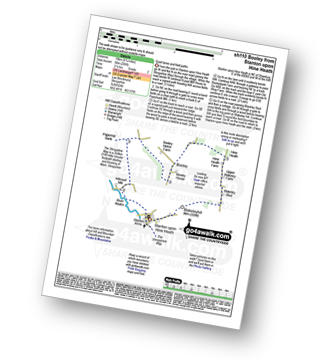
Route Summary:
Stanton Upon Hine Heath - The Shropshire Way - River Roden - Harcourt Mill - Paperbank Mill - Hardcourt Farm - The Woodlands - Booley - Old Shop Farm - Quarry Coppice - Megan's Coppice - Hine Heath - Hine Heath Farm - Upper Blakeley Farm - Blakeley Stud - Blakeleyhill - Stanton Upon Hine Heath
|
Vital Statistics:
| Length: | 5.25 miles (8.5 km) |
| Ascent: | 417ft (127m) |
| Time: | 2½ hrs |
| Grade: | |
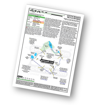
Route Summary:
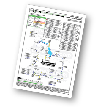
Whitegate - New Pool - Petty Pool - Pettypool Wood - Newchurch Common - Whitegate Way (Dismantled Railway) - Whitegate Station - Martonsands - Foxwist Green - Whitegate
|
Vital Statistics:
| Length: | 7.25 miles (11.5 km) |
| Ascent: | 404ft (123m) |
| Time: | 3 hrs |
| Grade: | |
Route Summary:
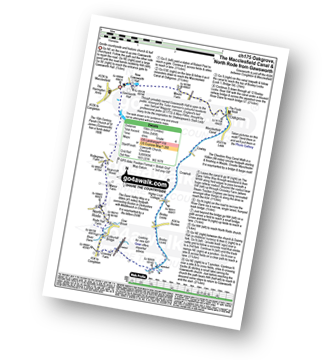
North Rode - Gawsworth - Oakgrove - The Macclesfield Canal - The Cheshire Ring Canal Walk - Bosley Locks - Big Dogbottom Wood - Station Wood - North Rode Manor Fish Pond - North Rode
|
Vital Statistics:
| Length: | 5.5 miles (8.5 km) |
| Ascent: | 896ft (273m) |
| Time: | 3 hrs |
| Grade: | |
Route Summary:
Rushton Spencer - Oulton - Woodhouse Green - Wood Common Farm - Avona - The Staffordshire Way - The Gritstone Trail - The Cloud (Bosley Cloud) - Bosley Cloud - Avona - The Dane Valley Way - Raven's Clough - Ravensclough Brook - Rushton Spencer
|
Vital Statistics:
| Length: | 9 miles (14.5 km) |
| Ascent: | 1,178ft (359m) |
| Time: | 4½ hrs |
| Grade: | |
Route Summary:
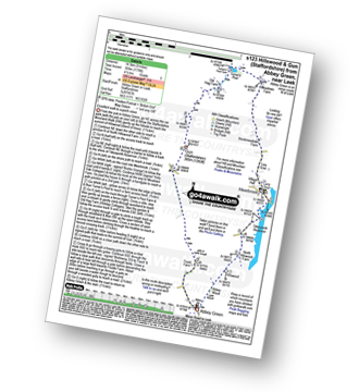
Abbey Green - Abbey Wood - Hillswood - North Hillswood Farm - Tittesworth Reservoir - Meerbrook - Lea End - Stockmeadows Farm - Meadows Farm - Turner's Pool - Old Hag Farm - Gun (Staffordshire) - Fould Farm - Abbey Green
|
Vital Statistics:
| Length: | 4.5 miles (7 km) |
| Ascent: | 341ft (104m) |
| Time: | 2 hrs |
| Grade: | |
Route Summary:
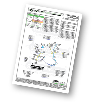
Bosley Locks - The Macclesfield Canal - The Cheshire Ring Canal Walk - River Dane Aquaduct - Railway Viaduct - Crossley Farm - Colleymill Bridge - North Rode - North Rode Manor Fish Pond - Station Wood - Big Dogbottom Wood - Bosley Locks
|
Vital Statistics:
| Length: | 7 miles (11 km) |
| Ascent: | 1,076ft (328m) |
| Time: | 3½ hrs |
| Grade: | |
Route Summary:
Leek - Mount Road - Holly House - Beely Barn - Morridge - Moor Top - Morridge Side - Egg Well - Roost Hill - Ashenhurst Mill - Lowe Hill - Leek
|
Vital Statistics:
| Length: | 7.5 miles (12 km) |
| Ascent: | 197ft (60m) |
| Time: | 3 hrs |
| Grade: | |
Route Summary:
Redes Mere - Redes Mere Nature Reserve - Fanshawe - Hills Green Farm - Hazelwall Farm - Henshaw Hall Farm - Heskey Wood - Snape Brook - Moss Wood - Crabtree Moss Farm - Marton Gate Farm - Northwood Farm - Sandbank Farm - Mere Moss Wood - Siddington Heath - Holly Cottage - Blake House Farm - Capesthorne Hall - Redes Mere
|
Vital Statistics:
| Length: | 4.75 miles (7.5 km) |
| Ascent: | 742ft (226m) |
| Time: | 2½ hrs |
| Grade: | |
Route Summary:
Ipstones - Booth's Hall Farm - Cherryeye Bridge - Caldon Canal - The Staffordshire Way - Podmores Bridge - Booth's Wood - Consall New Lock - Crowgutter Wood - Churnet Valley Railway - Consall Forge - River Churnet - Devil's Staircase - Belmont Hall - Noonsun Common - Ipstones
|
Vital Statistics:
| Length: | 9.25 miles (15 km) |
| Ascent: | 545ft (166m) |
| Time: | 4 hrs |
| Grade: | |
Route Summary:
Gawsworth - Oakgrove - The Macclesfield Canal - The Cheshire Ring Canal Walk - Bosley Locks - River Dane Aquaduct - Railway Viaduct - Crossley Farm - Colleymill Bridge - North Rode - Manor Farm - Beancroft Wood - Rodegreen Farm - Gawsworth
|
Vital Statistics:
| Length: | 9.5 miles (15 km) |
| Ascent: | 358ft (109m) |
| Time: | 3.75hrs |
| Grade: | |
Route Summary:
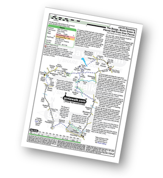
Over Peover - Peover Hall - Great Wood - Peover Eye - Woodend Farm - Blackden Heath - Redlion Brook - Goostrey - The Bongs - Swanwick Hall Farm - Booth Bed Lane - Boots Green - Meadowbank Farm - Long Lane - Peover Hall - Peover Hall Church - Peover Village Hall - Over Peover
|
Vital Statistics:
| Length: | 4 miles (6.5 km) |
| Ascent: | 830ft (253m) |
| Time: | 2.25hrs |
| Grade: | |
Route Summary:
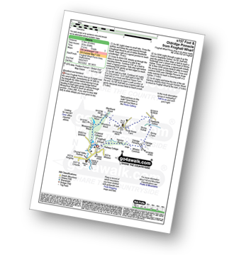
Froghall Wharf - Moseymoor Wood - Whieldon's Wood - Cloughead Wood - Blackbank Brook - Foxt - Newfields Gallery - Shirley Hollow - Oldridge Pinnacle - Harston Wood - Oldridge - Froghall Wharf
Not familiar with the area around CW3?
See these 30 nearest walks to UK Postcode CW3 on a google map


