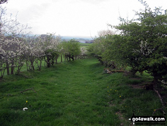
The delightful path by Swindale Beck back to Dufton
The North Pennines,
Cumbria, England
See views like this by using any of these 7 easy-to-follow circular walk route maps:
   |
Vital Statistics:
| Length: | 5 miles (8 km) |
| Ascent: | 703ft (214m) |
| Time: | 2½ hrs |
| Grade: |  |
Route Summary:
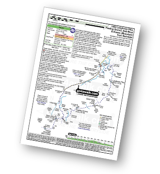
Dufton - The Pennine Way - Eller Beck - Church Bridge - Knock Church - Swindale Beck - Knock - Cosca Hill - Great Rundale Beck - Pisgill House - Dufton
|
Vital Statistics:
| Length: | 6.25 miles (10 km) |
| Ascent: | 1,352ft (412m) |
| Time: | 3.75hrs |
| Grade: |  |
Route Summary:
Swindale - Swindale Foot Farm - Swindale Beck - Starling Gill - Stubby Hest - Bracken Howe - Thiefstead - Langhowe Pike - High Katelade - Rowantree Crag - Blea Moss - Stone Howe - Glede Howe - Willy Winder Hill - Haskew Beck - Fewling Stones - Swindale Common - Mosedale Beck (Swindale) - Dodd Bottom - Hobgrumble Gill - Swindale Head Farm - Truss Gap - Swindale Foot Farm - Swindale
|
Vital Statistics:
| Length: | 7 miles (11 km) |
| Ascent: | 1,381ft (421m) |
| Time: | 4 hrs |
| Grade: |  |
Route Summary:
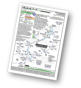
Hilton Town Head - Hilton Beck - Warcop Training Area - Swindale Brow - Swindale Beck - Swindale Edge - Marn Gill - Christy Bank - Siss Gill - Tinside Rigg - Long Fell - Howgill Fold - Cringle Beck - Lycum Sike - East Moor - Hilton Sike - Hilton Town Head
|
Vital Statistics:
| Length: | 8.5 miles (13.5 km) |
| Ascent: | 1,952ft (595m) |
| Time: | 5 hrs |
| Grade: |  |
Route Summary:
Swindale - Swindale Foot Farm - Swindale Beck - Starling Gill - Stubby Hest - Bracken Howe - Thiefstead - Langhowe Pike - High Katelade - Rowantree Crag - Blea Moss - Stone Howe - Glede Howe - Willy Winder Hill - Haskew Beck - Fewling Stones - Swindale Common - Mosedale Beck (Swindale) - Nabs Moor - Nabs Crag - Howes (Mosedale) - Nabs Crag - Nabs Moor - Dodd Bottom - Hobgrumble Gill - Swindale Head Farm - Truss Gap - Swindale Foot Farm - Swindale
|
Vital Statistics:
| Length: | 11.25 miles (18 km) |
| Ascent: | 2,629ft (801m) |
| Time: | 6.75hrs |
| Grade: |  |
Route Summary:
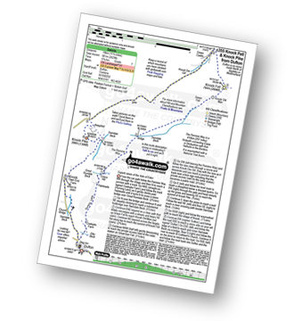
Dufton - The Pennine Way - Coatsyke Farm (Coatsike Farm) - Halsteads - Great Rundale Beck - Cosca Hill - Swindale Beck - Knock Old Man - Knock Fell - Green Castle - Knock Ore Gill - Knock Pike - Swindale Beck - Knock Village - Knock Church - Dufton
|
Vital Statistics:
| Length: | 11 miles (17.5 km) |
| Ascent: | 2,655ft (809m) |
| Time: | 6.75hrs |
| Grade: | |
Route Summary:
Swindale - Swindale Foot Farm - Swindale Beck - Starling Gill - Stubby Hest - Bracken Howe - Thiefstead - Langhowe Pike - High Katelade - Rowantree Crag - Blea Moss - Stone Howe - Glede Howe - Willy Winder Hill - Haskew Beck - Fewling Stones - Swindale Common - Mosedale Beck (Swindale) - Nabs Moor - Nabs Crag - Howes (Mosedale) - Captain Whelter Bog - Branstree (North East Top) - Branstree (Artlecrag Pike) - Swirle Crag - Selside Pike - High Blake Dodd - Selside End - High Birkin Knott - Low Birkin Knott - Old Corpse Road - Thorny Knott - Swindale Head Farm - Truss Gap - Swindale Foot Farm - Swindale
|
Vital Statistics:
| Length: | 15.75 miles (25 km) |
| Ascent: | 2,918ft (889m) |
| Time: | 8.75hrs |
| Grade: |  |
Route Summary:
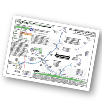
Hilton Town Head - Hilton Beck - Warcop Training Area - Swindale Brow - Swindale Beck - Swindale Edge - Marn Gill - Christy Bank - Siss Gill - Burton Fell - Little Fell (Burton Fell) - Hilton Fell - Arnside Rake - King's Pot - Mickle Fell - Fisher Sike - Maize Beck - Swarth Beck - Master Sike - Murton Fell - Murton Fell (SE Top) - Scordale - Lowfield Hush - Hilton Town Head
Send us your photographs and pictures of walks and hikes in the British countryside
If you would like to see your digital photographs as part of this collection, please send them as email attachments (configured for any computer) along with your name to:
and we shall do our best to publish them.
(Guide Resolution = 300dpi. At least = 587 pixels (wide) x 440 pixels (high).)

You can also submit photos via our Facebook Page.
NB. Please indicate where each photo was taken.
NB. To see photographs and pictures from a particular walk choose your walk from Walks or use our Walk Search facility.
To see photographs and pictures on, of or from a particular Mountain, Peak, Top or Hill select from Peaks & Mountains' or enter the Mountain, Peak, Top or Hill Name into our 'Photo Search facility.


