
![]()
Low Saddle (Coldbarrow Fell)
656m (2153ft)
The Central Fells, The Lake District, Cumbria, England
Not familiar with this top?
   |
|---|
Vital Statistics:
| Length: | 7.75ml (12.5km) |
|---|---|
| Ascent: | 2,419ft (737m) |
| Time: | 5.25hrs |
| Grade: |  (Moderate) (Moderate) |
Route Summary:
Stonethwaite - Stonethwaite Bridge - Stonethwaite Beck - The Cumbria Way - Wainwright's Coast to Coast Walk - Galleny Force - Greenup Gill - Lining Crag - Greenup Edge - Ullscarf - High Saddle (Coldbarrow Fell) - Low Saddle (Coldbarrow Fell) - Lord's How - Green Combe - Dock Tarn - Great Crag - Willygrass Gill - Stonethwaite
|
|---|
Vital Statistics:
| Length: | 7.75ml (12.5km) |
|---|---|
| Ascent: | 2,247ft (685m) |
| Time: | 5 hrs |
| Grade: | (Moderate) |
Route Summary:
Watendlath - High Tove - Middle Crag - Shivery Man - Shivery Knott - Long Moss - Blea Tarn (Watendlath Fell) - Ullscarf - High Saddle (Coldbarrow Fell) - Low Saddle (Coldbarrow Fell) - Lord's How - Green Combe - Dock Tarn - Great Crag - Watendlath
|
|---|
Vital Statistics:
| Length: | 11.25ml (18km) |
|---|---|
| Ascent: | 3,371ft (1,027m) |
| Time: | 7½ hrs |
| Grade: |  (Hard) (Hard) |
Route Summary:
Rosthwaite - Stonethwaite - Wainwright's Coast to Coast Walk - Stonethwaite Beck - Galleny Force - The Cumbria Way - Langstrath Beck - Eagle Crag - Sergeant's Crag - High Raise (Langdale) - Low White Stones - Greenup Edge - Ullscarf - High Saddle (Coldbarrow Fell) - Low Saddle (Coldbarrow Fell) - Lord's How - Dock Tarn - Willygrass Gill - Great Crag - Rosthwaite
|
|---|
Vital Statistics:
| Length: | 12ml (19km) |
|---|---|
| Ascent: | 3,502ft (1,067m) |
| Time: | 7.75hrs |
| Grade: |  (Hard) (Hard) |
Route Summary:
Stonethwaite - Wainwright's Coast to Coast Walk - Stonethwaite Beck - Galleny Force - The Cumbria Way - Langstrath Beck - Stake Pass - Pike of Stickle (Pike O' Stickle) - Harrison Stickle - Thunacar Knott - High Raise (Langdale) - Low White Stones - Greenup Edge - Ullscarf - Low Saddle (Coldbarrow Fell) - Willygrass Gill - Dock Tarn.
|
|---|
Vital Statistics:
| Length: | 12.25ml (19.5km) |
|---|---|
| Ascent: | 3,781ft (1,152m) |
| Time: | 8½ hrs |
| Grade: | (Hard) |
Route Summary:
Rosthwaite - The Cumbria Way - Stonethwaite - Wainwright's Coast to Coast Walk - Stonethwaite Beck - Galleny Force - The Cumbria Way - Langstrath Beck - Eagle Crag - Sergeant's Crag - High Raise (Langdale) - Low White Stones - Greenup Edge - Ullscarf - Low Saddle (Coldbarrow Fell) - Lord's How - Dock Tarn - Great Crag - Puddingstone Bank - Jopplety How - Joppletyhow Moss - Grange Fell (Brund Fell) - King's How - Rosthwaite
See Low Saddle (Coldbarrow Fell) and the surrounding tops on our free-to-access 'Google Style' Peak Bagging Maps:
The Central Fells of The Lake District National Park
Less data - quicker to download
The Whole of The Lake District National Park
More data - might take a little longer to download
See Low Saddle (Coldbarrow Fell) and the surrounding tops on our downloadable Peak Bagging Maps in PDF format:

NB: Whether you print off a copy or download it to your phone, these PDF Peak Baggers' Maps might prove incredibly useful when your are up there on the tops and you cannot get a phone signal.
*This version is marked with the walk routes you need to follow to Walk all 214 Wainwrights in just 59 walks.
You can find Low Saddle (Coldbarrow Fell) & all the walks that climb it on these unique free-to-access Interactive Walk Planning Maps:
1:25,000 scale OS Explorer Map (orange/yellow covers):
1:50,000 scale OS Landranger Maps (pink/magenta covers):
 Fellow go4awalkers who have already walked, climbed, summited & bagged Low Saddle (Coldbarrow Fell)
Kevin Foster walked up Low Saddle (Coldbarrow Fell) on May 27th, 2020 [from/via/route] Ullscarf. [with] Diana and Henry. [weather] Sunny & hot. - Steps were retraced to the fence corner on Coldbarrow Fell (reached on the ascent of Ullscarf). Then began a long descent northwards first over High Saddle then Low Saddle with superb views of Derwent water & Lake Bassenthwaite framed by the North Western Fells (left) & the Skiddaw range (right). A sweeping diversion to the left (west) to take in the sublime Dock Tarn is highly recommended on the return to Watlendlath rather than the direct route back if you have time. A fantastic day's walking which left me wanting to come back soon to this secluded area of The Lakes.
Mark Davidson climbed Low Saddle (Coldbarrow Fell) on October 11th, 2005 [with] Mike [weather] Typical October Day in The Lakes - a bit grey
Christine Shepherd bagged Low Saddle (Coldbarrow Fell) on May 25th, 2008 [from/via/route] Walked from Borrowdale using walk c243 [with] On my own [weather] Warm but overcast.
Iain Taylor hiked Low Saddle (Coldbarrow Fell) on May 22nd, 2011 [from/via/route] Wythburn NY 32084 12942)
Matthew Thomas and Mike Walker have both walked, climbed & bagged Low Saddle (Coldbarrow Fell).
To add (or remove) your name and experiences on this page - Log On and edit your Personal Mountain Bagging Record
More Photographs & Pictures of views from, on or of Low Saddle (Coldbarrow Fell)
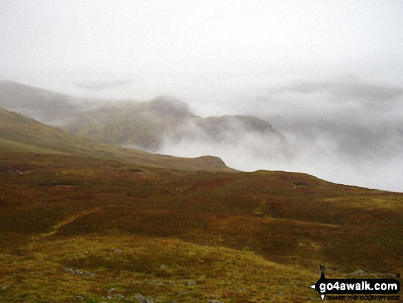
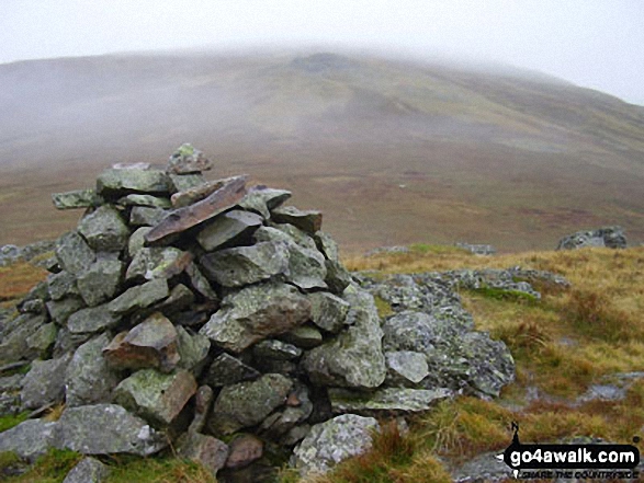
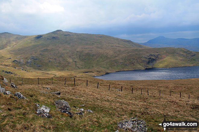
Green Combe, Lord's How and Blea Tarn from Low Saddle (Coldbarrow Fell)
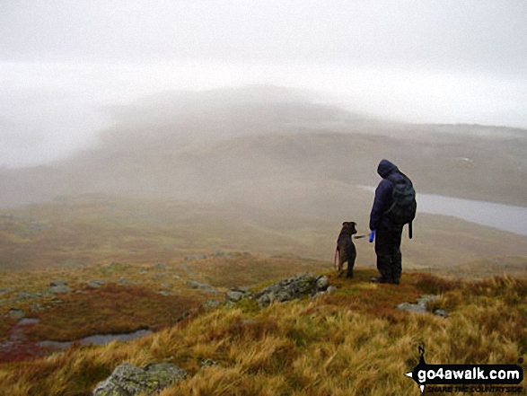
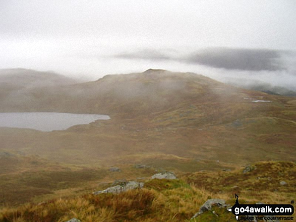
High Saddle (Coldbarrow Fell) (left) and Low Saddle (Coldbarrow Fell) from Bell Crags (Watendlath Fell)
Send us your photographs and pictures on, of, or from Low Saddle (Coldbarrow Fell)
If you would like to add your walk photographs and pictures featuring views from, on or of Low Saddle (Coldbarrow Fell) to this page, please send them as email attachments (configured for any computer) along with your name to:
and we shall do our best to publish them.
(Guide Resolution = 300dpi. At least = 660pixels (wide) x 440 pixels (high).)

You can also submit photos via our Facebook Page.
NB. Please indicate where each photo was taken and whether you wish us to credit your photos with a Username or your First Name/Last Name.
Not familiar with this top?


