
![]()
Low White Stones
733m (2406ft)
The Central Fells, The Lake District, Cumbria, England
Not familiar with this top?
You can walk/hike to the top of Low White Stones by using any of these 5 easy‑to‑follow route maps:
Walk c189 High Raise from Rosthwaite
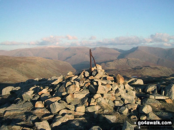
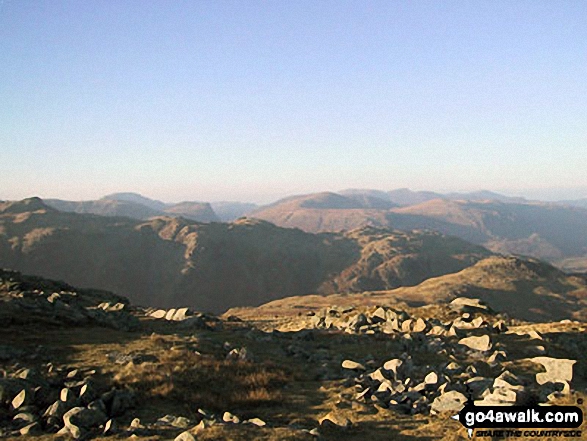
Superb view of Borrowdale
   |
|---|
Vital Statistics:
| Length: | 9ml (14.5km) |
|---|---|
| Ascent: | 2,780ft (847m) |
| Time: | 6 hrs |
| Grade: |  (Moderate) (Moderate) |
Route Summary:
Rosthwaite - Stonethwaite - Wainwright's Coast to Coast Walk - Stonethwaite Beck - Galleny Force - The Cumbria Way - Langstrath Beck - Eagle Crag - Sergeant's Crag - High Raise (Langdale) - Low White Stones - Greenup Edge - Lining Crag - Greenup Gill - Stonethwaite Beck - Stonethwaite - Rosthwaite
Walk c218 Ullscarf and High Raise from Thirlmere
Fine high level - can be boggy
|
|---|
Vital Statistics:
| Length: | 10ml (16km) |
|---|---|
| Ascent: | 2,635ft (803m) |
| Time: | 6.25hrs |
| Grade: | (Moderate) |

Route Summary:
Dob Gill Car Park (Thirlmere) - Harrop Tarn - Standing Crag - Ullscarf - Greenup Edge - Low White Stones - High Raise (Langdale) - Sergeant Man - Codale Head - Broadstone Head - Mere Beck - Brownrigg Moss - Calf Crag - Wyth Burn - Stockhow Bridge - Thirlmere
Walk c243 High Raise and Ullscarf from Rosthwaite
Fine views though N of Ullscarf - can be boggy
|
|---|
Vital Statistics:
| Length: | 11.25ml (18km) |
|---|---|
| Ascent: | 3,371ft (1,027m) |
| Time: | 7½ hrs |
| Grade: |  (Hard) (Hard) |

Route Summary:
Rosthwaite - Stonethwaite - Wainwright's Coast to Coast Walk - Stonethwaite Beck - Galleny Force - The Cumbria Way - Langstrath Beck - Eagle Crag - Sergeant's Crag - High Raise (Langdale) - Low White Stones - Greenup Edge - Ullscarf - High Saddle (Coldbarrow Fell) - Low Saddle (Coldbarrow Fell) - Lord's How - Dock Tarn - Willygrass Gill - Great Crag - Rosthwaite
Walk c329 The Langdale Pikes and High Raise from Stonethwaite
Superb ridge walk with magnificent views
|
|---|
Vital Statistics:
| Length: | 12ml (19km) |
|---|---|
| Ascent: | 3,502ft (1,067m) |
| Time: | 7.75hrs |
| Grade: |  (Hard) (Hard) |

Route Summary:
Stonethwaite - Wainwright's Coast to Coast Walk - Stonethwaite Beck - Galleny Force - The Cumbria Way - Langstrath Beck - Stake Pass - Pike of Stickle (Pike O' Stickle) - Harrison Stickle - Thunacar Knott - High Raise (Langdale) - Low White Stones - Greenup Edge - Ullscarf - Low Saddle (Coldbarrow Fell) - Willygrass Gill - Dock Tarn.
Walk c369 High Raise, Ullscarf and Grange Fell from Rosthwaite
Good views though N of Ullscarf can be boggy
|
|---|
Vital Statistics:
| Length: | 12.25ml (19.5km) |
|---|---|
| Ascent: | 3,781ft (1,152m) |
| Time: | 8½ hrs |
| Grade: | (Hard) |
Route Summary:
Rosthwaite - The Cumbria Way - Stonethwaite - Wainwright's Coast to Coast Walk - Stonethwaite Beck - Galleny Force - The Cumbria Way - Langstrath Beck - Eagle Crag - Sergeant's Crag - High Raise (Langdale) - Low White Stones - Greenup Edge - Ullscarf - Low Saddle (Coldbarrow Fell) - Lord's How - Dock Tarn - Great Crag - Puddingstone Bank - Jopplety How - Joppletyhow Moss - Grange Fell (Brund Fell) - King's How - Rosthwaite
See Low White Stones and the surrounding tops on our free-to-access 'Google Style' Peak Bagging Maps:
The Central Fells of The Lake District National Park
Less data - quicker to download
The Whole of The Lake District National Park
More data - might take a little longer to download
See Low White Stones and the surrounding tops on our unique, downloadable, PDF Peak Bagging Maps:

NB: Whether you print off a copy or download it to your phone, these PDF Peak Baggers' Maps might prove incredibly useful when your are up there on the tops and you cannot get a phone signal.
*This version is marked with the walk routes you need to follow to Walk all 214 Wainwrights in just 59 walks.
You can find Low White Stones & all the walks that climb it on these unique free-to-access Interactive Walk Planning Maps:
1:25,000 scale OS Explorer Maps (orange/yellow covers):
1:50,000 scale OS Landranger Maps (pink/magenta covers):
 Fellow go4awalkers who have already walked, climbed, scaled, summited, hiked & bagged Low White Stones
Simon Myerscough walked up Low White Stones on September 20th, 2009 [from/via/route] C369 [with] Martin [weather] Warm & sunny, no wind - Large shelter for dinner on High Raise. 4pm & still beautiful.
Graham Coules climbed it on September 19th, 2017 [from/via/route] Grasmere [weather] Sunny & misty
Mark Davidson bagged it on December 11th, 2002 [with] Mike [weather] Cold but with clear blue skies - just wonderful - Made a detour to visit Low White Stones
David Lane hiked Low White Stones on July 28th, 2006 [with] Kelly
Iain Taylor summited on April 3rd, 2011 [from/via/route] Langdale (NY 29589 06415)
Les Wrightson conquered it on July 21st, 2012 [from/via/route] rosthwaite [with] tan c369 [weather] good
Christine Shepherd scaled it on April 4th, 2007 [from/via/route] Walked from Grasmere using walk c302 [with] On my own [weather] Cold but bright & clear - I have reached Low White Stones several times from both Grasmere & Borrowdale. It is nearly always boggy here but is a crossing point for lots of great walks.
David Buttress has walked, climbed & bagged Low White Stones.
To add (or remove) your name and experiences on this page - Log On and edit your Personal Mountain Bagging Record
More Photographs & Pictures of views from, on, or of, Low White Stones
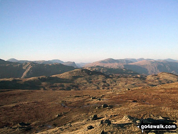

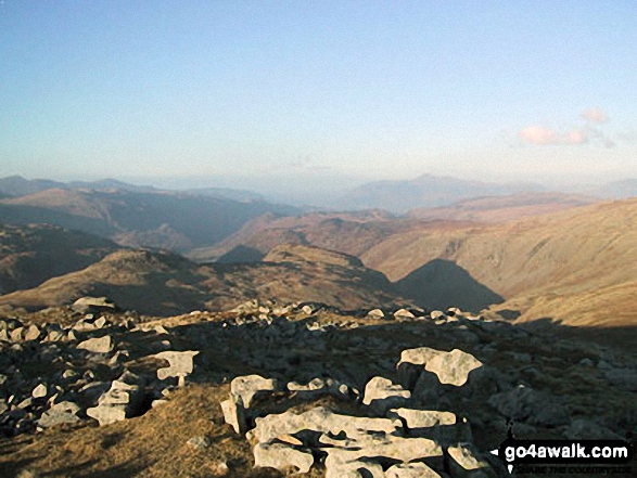
Low White Stones (foreground) with Borrowdale beyond from High Raise (Langdale)
Send us your photographs and pictures on, of, or from Low White Stones
If you would like to add your walk photographs and pictures to this page, please send them as email attachments (configured for any computer) along with your name to:
and we shall do our best to publish them.
(Guide Resolution = 300dpi. At least = 660pixels (wide) x 440 pixels (high).)

You can also submit photos via our Facebook Page.
NB. Please indicate where each photo was taken and whether you wish us to credit your photos with a Username or your First Name/Last Name.


