
![]()
Angletarn Pikes
567m (1861ft)
The Far Eastern Fells, The Lake District, Cumbria, England
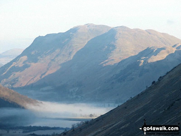
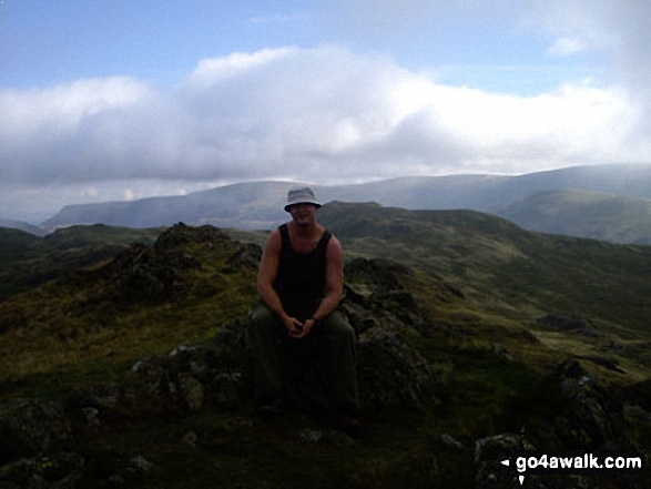
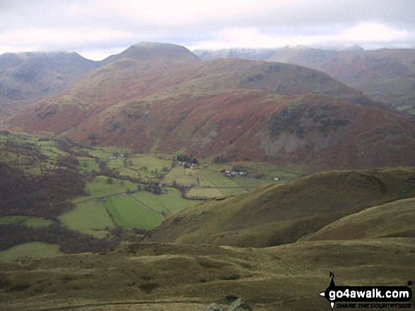
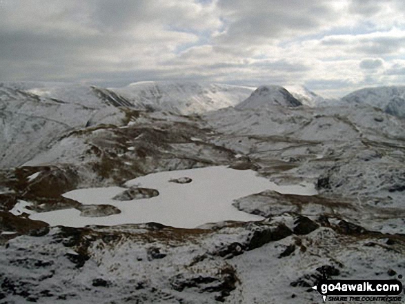
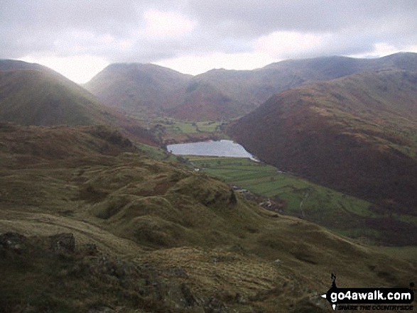
Brothers Water under mist with Angletarn Pikes and Place Fell beyond from the Kirkstone Pass
Not familiar with this top?
   |
|---|
Vital Statistics:
| Length: | 9ml (14.5km) |
|---|---|
| Ascent: | 2,619ft (798m) |
| Time: | 6 hrs |
| Grade: |  (Moderate) (Moderate) |
Route Summary:
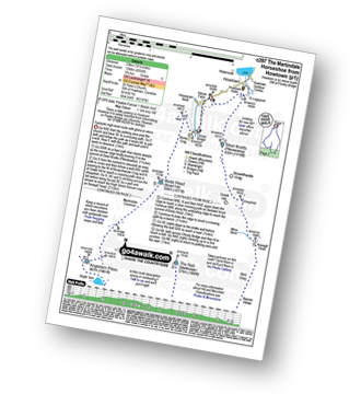
Patterdale - Side Farm - Boredale Hause - Angletarn Pikes - Angle Tarn (Martindale) - Satura Crag - Brock Crags - Satura Crag - The Knott - Hayeswater Reservoir - Hayeswater Gill - Hartsop - Dubhow - Beckstones - Crookabeck - Rooking - Side Farm - Patterdale
|
|---|
Vital Statistics:
| Length: | 9.75ml (15.5km) |
|---|---|
| Ascent: | 3,470ft (1,058m) |
| Time: | 7 hrs |
| Grade: |  (Hard) (Hard) |
Route Summary:
St Peter's Church (Martindale) - Howtown - Howegrain Beck - Christy Bridge - Beda Head (Beda Fell) - Martindale Common - Angletarn Pikes - Angle Tarn (Martindale) - Boredale Hause - Steel Edge - Place Fell - High Dodd (Sleet Fell) - Sandwick - Hallinhag Wood - Geordies Crag - Hallin Fell (Martindale) - Howtown
|
|---|
Vital Statistics:
| Length: | 12.5ml (20km) |
|---|---|
| Ascent: | 3,889ft (1,185m) |
| Time: | 8½ hrs |
| Grade: |  (Hard) (Hard) |
Route Summary:
Cow Bridge - Brothers Water - Hartsop - Hartsop Dodd - Stony Cove Pike - Caudale Head - Caudale Moor - Stony Cove Pike (Caudale Moor) - Threshthwaite Mouth - Thornthwaite Crag - High Street - Straits of Riggindale - The Knott - Angle Tarn (Martindale) - Angletarn Pikes - Boredale Hause - Patterdale
|
|---|
Vital Statistics:
| Length: | 14.5ml (23km) |
|---|---|
| Ascent: | 4,555ft (1,388m) |
| Time: | 9.75hrs |
| Grade: |  (Very Hard) (Very Hard) |
Route Summary:
St Peter's Church (Martindale) - Howtown - Steel Knotts (Pikeawassa) - Keasgill Head - High Raise (Mardale) - Kidsty Pike - Rampsgill Head - The Knott - Rest Dodd - The Nab - Satura Crag - Brock Crags - Angle Tarn (Martindale) - Angletarn Pikes - Bedafel Knott - Beda Head (Beda Fell) - Winter Crag - Christy Bridge - Howegrain Beck - Martindale - St Peter's Church (Martindale) - Howtown
|
|---|
Vital Statistics:
| Length: | 15.5ml (25km) |
|---|---|
| Ascent: | 4,293ft (1,308m) |
| Time: | 10 hrs |
| Grade: | (Very Hard) |
Route Summary:
Patterdale - Rooking - Crookabeck - Beckstones - Dubhow - Hartsop - Hayswater Gill - Hayswater - The Knott - Brock Crags - Angle Tarn (Martindale) - Angletarn Pikes - Boredale Hause - Place Fell - High Dodd (Sleet Fell) - Sandwick - Long Crag - Silver Point - Ullswater - Blowick - Rooking - Side Farm - Patterdale
See Angletarn Pikes and the surrounding tops on our free-to-access 'Google Style' Peak Bagging Maps:
The Far Eastern Fells of The Lake District National Park
Less data - quicker to download
The Whole of The Lake District National Park
More data - might take a little longer to download
See Angletarn Pikes and the surrounding tops on our downloadable Peak Bagging Maps in PDF format:

NB: Whether you print off a copy or download it to your phone, these PDF Peak Baggers' Maps might prove incredibly useful when your are up there on the tops and you cannot get a phone signal.
*This version is marked with the walk routes you need to follow to Walk all 214 Wainwrights in just 59 walks.
You can find Angletarn Pikes & all the walks that climb it on these unique free-to-access Interactive Walk Planning Maps:
1:25,000 scale OS Explorer Map (orange/yellow covers):
1:50,000 scale OS Landranger Map (pink/magenta covers):
 Fellow go4awalkers who have already walked, climbed, summited & bagged Angletarn Pikes
Mr M A Blanchard walked up Angletarn Pikes on October 30th, 2025 [with] The mutts
Geoff Hand climbed Angletarn Pikes on July 25th, 2025 [from/via/route] Walk 304. Walked from St Peters Church to Christy Bridge then along the ridge to Beda Head, carried on South from there to Angletarn Pikes,(2 pikes) then heading North Again & upto Place Fell. Down & up took us to High Dodd then down to Sandwick & into Hallinhag Wood. We finally climbed through the ferns to reachHallin Fell. [with] Richard MaCillwaine. [weather] Cloud increasing as the morning progressed ending up foggy & drissly on Place fell, then clearing as we reduced height. - Last of the fells completed in the Far East section.
James Hughes bagged Angletarn Pikes on September 17th, 2024 [from/via/route] c159 The Nab & Rest Dodd from Christy Bridge [weather] Beautiful clear warm day. - Long day added Beda Fell & Angletarn Pikes to start of walk. Slight variations up to Brock Crags & the Nab. Nab very boggy in places. Stags & Bucks mating calls in valley. Parked at Church at the Coombs below Hallin Hill. Stayed at Waterside Campsite.
Angeline Grieveson hiked Angletarn Pikes on July 21st, 2024 [with] Dotty & Rick
Vincent Clarke summited Angletarn Pikes on May 4th, 2024 [from/via/route] Patterdale [with] Austin [weather] Great hike up To angle tarn
Martin Hartshorne conquered Angletarn Pikes on March 22nd, 2024 [from/via/route] St Peters church [with] finley [weather] Blue skies & clouds super windy on the tops, stayed dry tho!
Sarah Wild scaled Angletarn Pikes on November 3rd, 2023 [from/via/route] With AnnewithBrock Crags from Hartsop [with] Anne [weather] Sun & cloud - 2 today
Steve Lucas walked up Angletarn Pikes on October 30th, 2021 [with] On my own
Pete George climbed Angletarn Pikes on March 26th, 2023 [from/via/route] Howtown [with] Roco, Pete and Poppy [weather] Clear, cool. Snow flurries - With another vizsla too
Caroline Winter bagged Angletarn Pikes on December 2nd, 2022 [from/via/route] Martindale church, Place Fell, Angle tarn Pikes, ridge down to Martindale [with] Neil and Shaker [weather] Clear, sunny, & cold - Great little ridge walk. Enjoyed a cuppa after Place fell on the new log burner cooker
Ian Ashton hiked Angletarn Pikes on November 19th, 2022 [with] With JPH
Christine Shepherd summited Angletarn Pikes on February 19th, 2010 [from/via/route] Walk 304 from Howtown [with] On my own [weather] Freezing & grey. - This is probably one of the eeriest walks I have done. I saw no-one & the frozen summits looked like a moonscape. Angle Tarn was frozen & covered in a layer of snow. I didn't do the whole walk as I decided it was safer to turn back after bagging this peak. Bagged this again on a lovely hot day on 9.7.17 Climbed for a third time on 10.08.22. I walked to Howtown from Patterdale over Place Fell & back over Beda Fell. After climbing to the summit of The Pikes I had a wonderful swim in Angle Tarn to cool off after a very hot walk.
John Ramsbottom conquered Angletarn Pikes on May 2nd, 2022 [from/via/route] Howtown, walk c304 [with] Skratch and Lola [weather] misty then fine weather - solo walk with dogs
Simon Burgess scaled Angletarn Pikes on June 27th, 2021 [from/via/route] Overnight Camp [with] Solo
Tim Winn walked up Angletarn Pikes on August 10th, 2021 [from/via/route] Cow Bridge Car Park, Brothers Water [with] Louise and Barry [weather] Good
John Bryers climbed Angletarn Pikes on July 11th, 2021 [from/via/route] Parked at Cow Bridge car park near Hartsop. Set off at 8:45am in low mist & light rain. Walked along bridleway towards Patterdale & veared upwards along a track to Boredale Hause. Turning right to Angletarn Pikes. Walked to top of each pike to make sure I'd completed the Wainright. [with] With Mya my faithful 14 yeara old Patterdale Terrier. [weather] Light rain & mist across most tops at start of walk. Cleared to be a lovely warm day overall. - Wore waterproof for 15 minutes during climb to Angletarn pikes & tarn. Around 5 tents camped along the shores. A nice plave to camp!
Richard Marshall bagged Angletarn Pikes on May 26th, 2021 [from/via/route] RM super route from Martindale 19 miles 6300ft ascent [with] Roxy & Bo [weather] Showers,fog, sun & very wet underfoot
Neil Heywood hiked Angletarn Pikes on April 17th, 2021 [with] logan Heywood Ellis Heywood
Tony Kenny summited Angletarn Pikes on July 20th, 2011 [from/via/route] From Brotherswater, wild camp at Angle Tarn [with] Kitty
Adrian Howard conquered Angletarn Pikes on June 10th, 2019 [from/via/route] Deepdale Bridge, Patterdale
Gill Bates scaled Angletarn Pikes on June 25th, 2016 [from/via/route] from Howtown
Andrew Johnson walked up Angletarn Pikes on November 19th, 2019 [from/via/route] Hartsop [weather] Beautiful day, clear skies.
Michael Nolan climbed Angletarn Pikes on October 22nd, 2019 [from/via/route] Hartsop [with] Morag [weather] fine & sunny
Robin Thorne bagged Angletarn Pikes during May, 2018 [from/via/route] Coast to Coast Walk [with] Jon Thorne [weather] Sunny
Richard Marchant hiked Angletarn Pikes during July, 1988 [from/via/route] This was a two week trip Whilst walking the Coast to Coast footpath from St Bees to Robin Hoods Bay & this particular day I camped overnight next to Angle Tarn. The next day I took in the Wainwrights of Angletarn Crag, The Knott, Rampsgill Head, Kidsty Pike & descended to Haweswater & merrily made my way along on the C2C walk where I met my good friend Ray Collins from Sunderland & we are still walking together most of the time to this day. [with] On my own for this trip [weather] Mainly fine weather for the two weeks - It was on this trip I met my life long good friend Ray Collins from Sunderland
Wayne Baxter summited Angletarn Pikes on May 12th, 2019 [from/via/route] Patterdale to Shap on the coast to coast walk [with] Sue, Wendy & Trevor [weather] Sunny
Tom Mcbeath conquered Angletarn Pikes on November 10th, 2018 [from/via/route] Hartsop Fold lodges to Boredale House, Anglepike Tarn & the onto The Knott [with] Ursula [weather] Very windy on top but clear skies on top - Views were fantastic. Could see the cloud line & the rain coming in from the direction of theKirkstone Pass.
Chris Sheard scaled Angletarn Pikes on September 26th, 2018 [from/via/route] Up from Cow Bridge. [with] George [weather] Started with mist & high winds finished calm & warm - NOT what the weathermen said - Again over some of the Coast to coast route. Two young Korean girls doing coast to coast using footprint. Windy misty & micro climate day - best area in lake district that day
Julian Parry walked up Angletarn Pikes on June 22nd, 2018 [from/via/route] C304 [with] Nuno Malo
Christina Lander climbed Angletarn Pikes on June 7th, 2018 [from/via/route] Martindale - Steel Knotts - High Raise - Kidsty Pike - Rampsgill Head - The Knott - Rest Dodd - Angletarn Pikes - Beda Fell - Martindale [with] Dick [weather] A perfect sunny day on the fells
Phillip Bulley bagged Angletarn Pikes on May 6th, 2018 [from/via/route] Via Brock Crags [with] Judith and Ruby. [weather] Sunny but breezy.
Simon Myerscough hiked Angletarn Pikes on July 30th, 2006 [from/via/route] C304 [with] Martin [weather] Warm sunshine, cool breeze
Paul Macey summited Angletarn Pikes on August 13th, 2017 [from/via/route] C304 Glenridding
Beth Webster conquered Angletarn Pikes on May 29th, 2017 [with] Hannah phillips & Cocoa
John Tippins scaled Angletarn Pikes on April 11th, 2017 [from/via/route] Howtown [with] Alone [weather] Almost complete cloud cover, but above the highest peaks until mid-afternoon when it started to get misty lower down. Dry day & a bit blustery, bit chilly at times. - First day out after electricity failure the previous day.
Elaine Evans walked up Angletarn Pikes on March 3rd, 2017 [from/via/route] From Martindale old church, up to Angle Tarn, Angletarn Pikes, then along Beda Fell before descending & returning to car. [with] Sue [weather] Dry & mild for most of the day, light rain started just as we began the descent off Beda. - Lots of deer to be seen on the ridges & in the valleys.
Mark Davidson climbed Angletarn Pikes on November 28th, 2004 [with] Mike [weather] Bit grey & gloomy
John Walter bagged Angletarn Pikes on October 26th, 2016 [from/via/route] Howtown [with] Tricia Sandra jennifer
David Watson hiked Angletarn Pikes on August 24th, 2016 [from/via/route] Patterdale via Boredale Hause [with] Tilda Watson [weather] Sunny
John Almond summited Angletarn Pikes on August 26th, 2016 [from/via/route] Solo walk from from St Peter's Church, Howtown - Beda Head - Angletarn Pikes - Hallin Fell [weather] Good
Jon Mapp conquered Angletarn Pikes on July 30th, 2016 [from/via/route] c304/159 combined as we had done some of the peaks before we used these walks [with] Suzzann� [weather] Dry & warm, cloudy later, with a little rain - Nice walk, good climb to Beda Head, a little boggy to Angletarn Pikes - with a good path to the turn off to Brock Crags then bog again. Rest Dodd is a good climb but the top appeared sooner than expected, the walk to The Nab was very boggy, it must be really bad in wetter weather. Cheated by coming down a small path off The Nab to Christy Bridge.
Richard Fulcher scaled Angletarn Pikes on June 3rd, 2016 [from/via/route] Howtown c304 [with] Alone [weather] Fine - Missed the lower pike & view of Angle Tarn
Dave Eyes walked up Angletarn Pikes on April 16th, 2016 [from/via/route] Walked in from Hartsop [with] Christine Eyes, John and Martine Power [weather] Sunny & clear but a cold wind & occasional snow flurries
Anthony Scott climbed Angletarn Pikes on April 18th, 2016 [from/via/route] Martindale church [with] me [weather] Bitingly cold wind, cloudy & drizzle - Walk c304 used. Very easy to follow.
Tracey Cowell bagged Angletarn Pikes on March 25th, 2016 [from/via/route] Bridge end/Boredale Hause/ Angletarn Pikes/Angle tarn/Hartsop/Bridge End. [with] Solo [weather] Sunny/Cloudy/Cold Wind approx 25/30mph on summits.
Charlie Housley hiked Angletarn Pikes on January 1st, 2016 [from/via/route] From Bridgend via Stoney Rigg & up the West flank. [with] Joanna and Candy. [weather] Frosty, windy & sunless. Great walking weather.
Michael Smyth summited Angletarn Pikes on October 14th, 2015 [from/via/route] Hartsop [with] Brampton Fell Walkers [weather] Sunny perfect conditions - A good walk in good company
Tony Rogerson conquered Angletarn Pikes on May 6th, 2010 [from/via/route] Angle Tarn Camp from Howtown [with] John [weather] High cloud, sunny spells
Nick Dobson scaled Angletarn Pikes on September 23rd, 2015 [from/via/route] hartsop via brock crags [with] Ralph [weather] overcast with strong winds & showers
Victoria Bates walked up Angletarn Pikes on September 3rd, 2015 [from/via/route] c297 with Wether Hill & Loadpot Hill [with] Mark
Steve Frank climbed Angletarn Pikes on July 12th, 2015 [from/via/route] How Town
Les Wrightson bagged Angletarn Pikes on August 8th, 2015 [from/via/route] c304 from howtown [with] tanya [weather] sunny/warm
David Fearn hiked Angletarn Pikes on June 23rd, 2015 [from/via/route] From the Howtown Hotel via walk c304 [with] Alone [weather] Beautiful day fantastic views of Ullswater, Brothers Water & surrounding Fells - Walked from Howtown Hotel up the Howtown zig zags passed St Peters Church, Ascended via Beda Head, continued on to Place Fell descended to Sandwick, Did not climb Hallin Fell returned to Howtown Hotel.
David Baines summited Angletarn Pikes on May 2nd, 2015 [from/via/route] Patterdale-Boredale Hause [with] Alone [weather] Bright start. Deteriorated on top, some snow flurries, light rain back at start. - Bit of scrambling required just below summit.
Craig Steeland conquered Angletarn Pikes on April 21st, 2015 [from/via/route] From Howtown via Beda Head [with] On my own [weather] Sunny & warm with no wind - Great traverse from Beda head with views of The Nab & the deer park. Saw dozens of red deer down in Martindale & on the surrounding hillsides. Fantastic views from the summit, including Hayeswater.
David Noble scaled Angletarn Pikes on April 2nd, 2015 [from/via/route] Howtown [weather] Sunny Day great views - Climbed up front of summit
Kevin Parnham walked up Angletarn Pikes on September 20th, 2014 [from/via/route] Beda Head [with] Jo [weather] Clear & generally sunny - Great views of Brothers Water
Ann Davis climbed Angletarn Pikes on July 26th, 2014 [from/via/route] patterdale [weather] hot & humid
Keith Eastman bagged Angletarn Pikes on July 1st, 2014 [from/via/route] c304
Simon Boddy hiked Angletarn Pikes on June 10th, 2014 [from/via/route] Howtown [with] Girlfriend [weather] Sunny, windy
Clive Ward summited Angletarn Pikes on May 2nd, 2014 [from/via/route] Hartsop, Boredale Hause, Brock Crags, down via reservoir [with] Hazel [weather] Dry, part cloud, quite cool - On way to lodge
Harry Meijer conquered Angletarn Pikes on June 17th, 2014 [from/via/route] The Martindale Skyline [with] The Lake District Walker
Lee Maddison scaled Angletarn Pikes on February 27th, 2014 [from/via/route] Walk c304 - Beda Head & Place Fell from Howtown [with] Solo [weather] Sunny - moderate wind on summit
Darren Wilson walked up Angletarn Pikes on October 13th, 2013 [from/via/route] Martindale Round Wether Hill, Red Crag, High Raise, Satura Crag, Angletarn Pike [with] Mike Wilson [weather] sunny dry & windy
Darren Gallagher climbed Angletarn Pikes on October 29th, 2013 [from/via/route] Patterdale
Martin Leighfield bagged Angletarn Pikes on September 13th, 2012 [from/via/route] Coast to Coast Walk [with] Andrew Leighfield [weather] Sunny
Tim Buckley hiked Angletarn Pikes on June 2nd, 2011 [from/via/route] From Patterdale. Started at 10.30 returned to Patterdale by 2.30. [with] Lynne. [weather] Hot & sunny. - Angle Tarn is a lovely place to visit.
Dale Verrall summited Angletarn Pikes on September 13th, 2012 [from/via/route] Pooley Bridge to Patterdale [with] Amber [weather] Wet windy
Iain Taylor conquered Angletarn Pikes on March 6th, 2011 [from/via/route] Hause Farm
Darren Mortimer scaled Angletarn Pikes on August 19th, 2012 [from/via/route] Martindale [with] Dermot Palmer [weather] Sunny at first then wet
Chris Bramley walked up Angletarn Pikes on June 10th, 2012 [from/via/route] Hartsop [with] Jan,Daz and Harry [weather] Warm showery
Stephen Littlewood climbed Angletarn Pikes on June 11th, 2009 [from/via/route] from Martindale
Christine Knowles bagged Angletarn Pikes on March 19th, 2011 [from/via/route] Brotherswater [with] Graham, Sheila, Jeff [weather] Lovely
Beverley Kelly hiked Angletarn Pikes on October 16th, 2009 [from/via/route] Roughly Walk C304 Beda Head, Angletarn, Place Fell, High Dodd, Sleet Fell back to Martindale Church [with] Iris [weather] Beautifull mainly sunny day, warm for time of year - Ruttinf Deer on Beda Fell. Loved the walk although we took a long time & had to rescue Iris from Bridge End as her Knees had given up.
Stephen Byrne, Katherine Bonner, Patrick Rogozinski, Andrew Martin, Matthew Thomas, Alex Jones, David Hallam, Adrian Roberts, Dale Sexton, Wendy Sockett, Melanie Dunn, Jane Wilkinson, Jenny Godfrey, David Kelley, Jo Dixon, David Kelley, Louise Sandwith, David Shaw, Louis Smith, Claire Rigg, Edward Wells, David Butterfield, Wendy Haycock, Patricia Dilley, Jonathan Tobin, Simon Duerden, Colin Egan, Sarah Lowe, Paul Booth, Mark Smith, David Buttress, Linda Mckeogh, Trevor Williams, Jeff Ansell, Paul Henderson, John Cuthbert, Patrick Buckland, Rob Barklamb, Stephen Millington, Chris Bede, Mike Walker, Jeanette Coward, Jacqui Smith, Ray O'hara, Linda Walker, Libby Burns and John Southward have all walked, climbed & bagged Angletarn Pikes.
To add (or remove) your name and experiences on this page - Log On and edit your Personal Mountain Bagging Record
. . . [see less walk reports]
More Photographs & Pictures of views from, on or of Angletarn Pikes
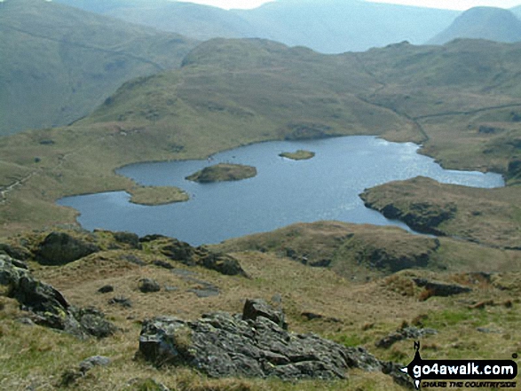
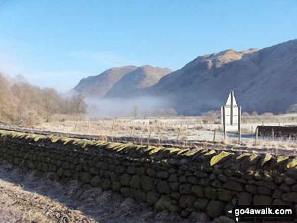
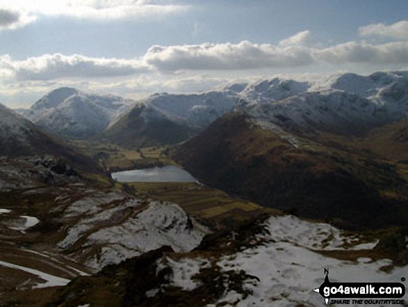
Early Morning Mist nr Hartsop Village with The Angletarn Pikes and Place Fell in the background
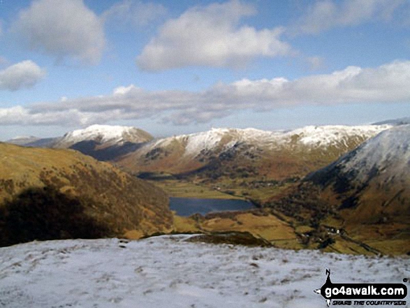
Place Fell and Angletarn Pikes above Brothers Water from High Hartsop Dodd
Send us your photographs and pictures on, of, or from Angletarn Pikes
If you would like to add your walk photographs and pictures featuring views from, on or of Angletarn Pikes to this page, please send them as email attachments (configured for any computer) along with your name to:
and we shall do our best to publish them.
(Guide Resolution = 300dpi. At least = 660pixels (wide) x 440 pixels (high).)

You can also submit photos via our Facebook Page.
NB. Please indicate where each photo was taken and whether you wish us to credit your photos with a Username or your First Name/Last Name.
Not familiar with this top?


