Walk The Glen Etive Hills (West) area of Scottish Region 3: Loch Leven to Connel Bridge, Strath of Orchy and Glen Lochy, Scotland - 10 Mountains, Tops, Peaks and Hills
The Glen Etive Hills (West) area of Loch Leven to Connel Bridge, Strath of Orchy and Glen Lochy region of Scotland is the area enclosed by an imaginary line connecting:
- Elleric to Gualachulain via Glen Ure to the North
- Gualachulain to Taynuilt via Loch Etive to the South East
- Taynuilt to the Lynn of Lorn via Loch Etive to the South
- Lynn of Lorn to Elleric via Loch Creran, Creagan & Glen Creran to the North West
There are 10 'tops' to walk up, bag and conquer, the highest point is Beinn Sgulaird and the area includes:
| 1 | Munro | |
| 2 | Corbetts | |
| 3 | Grahams | |
| 0 | Donalds | |
| 1 | Murdo | |
| 10 | Marilyns | |
| 0 | Hills (aka Bridgets) and | |
| 4 | Mountains, Tops, Peaks or Hills with a Trig Point on or near the top |
See these 10 Mountains, Tops, Peaks and Hills:-
- On a Special PDF Peak Baggers Map# you can download and print or save to your phone detailing all these tops.
- On an Interactive Google Map with a list of tops below it
- On a Detailed List
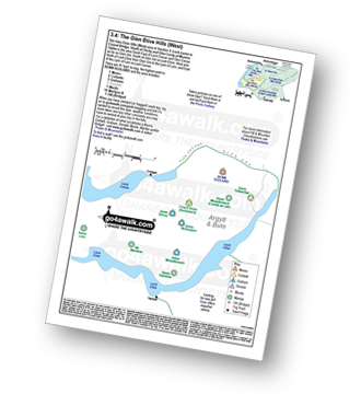 Peak Baggers Map you can Print or Save to your Phone detailing The Glen Etive Hills (West) area of Section 3.4: Loch Leven to Connel Bridge, Strath of Orchy and Glen Lochy
# Whether you print a copy or download it to your phone, this Peak Baggers' Map will be essential if you want to know what's what when you are up in the hills and mountains and cannot get a phone signal.


