Walk Scottish Region 4: Fort William and Loch Linnhe to Loch Ericht, Scotland - 80 Mountains, Tops, Peaks and Hills
Fort William and Loch Linnhe to Loch Ericht region of Scotland is the area enclosed by an imaginary line connecting:
- Fort William to Gairlochy via the River Lochy to the North West
- Gairlochy to Newtonmore via the B8004 to the Commando Memorial, the A82 to Spean Bridge and then the A86 through Roy Bridge, Glen Spean, Loch Laggan & Strath Mashie to the North
- Newtonmore to Rannoch Station via the A9 through Glen Truim to Dalwhinnie and then Loch Ericht to the South East
- Rannoch Station to Onich via Black Water, Loch Leven, Glencoe, North Ballachulish & Loch Linnhe to the South
- Onich to Fort William via Loch Linnhe to the West
There are 80 'tops' to walk up, bag and conquer, the highest point is Ben Nevis and the area includes:
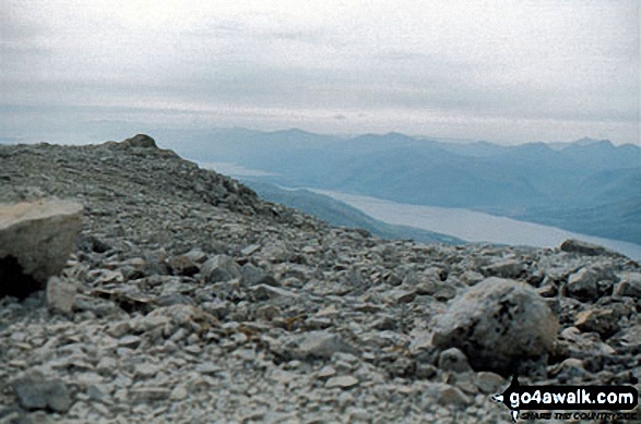 The summit of Ben Nevis
Photo: John Reed
| 34 | Munros | |
| 7 | Corbetts | |
| 8 | Grahams | |
| 0 | Donalds | |
| 57 | Murdos | |
| 46 | Marilyns | |
| 1 | Hill (aka Bridget) and | |
| 9 | Mountains, Tops, Peaks or Hills with a Trig Point on or near the top |
See these 80 Mountains, Tops, Peaks and Hills:-
- On an Interactive Google Map with a list of tops below it
- On a Detailed List in:
Alphabetical Order | Height Order - On one page with 'yet-to-be-bagged' listed 1st
& then 'already-bagged' tops listed 2nd in:
Alphabetical Order | Height Order - On one page with 'already-bagged' tops listed 1st
& then 'yet-to-be-bagged' tops listed 2nd in:
Alphabetical Order | Height Order


