Walk Scottish Region 7: The East Mounth - Glen Shee and Mount Keen to Montrose, Scotland - 56 Mountains, Tops, Peaks and Hills
The East Mounth - Glen Shee and Mount Keen to Montrose region of Scotland is the area enclosed by an imaginary line connecting:
- Braemar to Aberdeen via the A93 through Ballater, Aboyne, Banchory and Peterculter to the North
- Aberdeen to Stonehaven via the North Sea to the East
- Stonehaven to Blairgowrie and Rattray via the A926 through Laurencekirk, Brechin, Kirriemuir & Alyth to the South East
- Blairgowrie and Rattray to Braemar via the A9 through Bridge of Cally, Cray, Spittal of Glenshee, and Glen Shee to the West
There are 56 'tops' to walk up, bag and conquer, the highest point is Lochnagar (Cac Carn Beag) and the area includes:
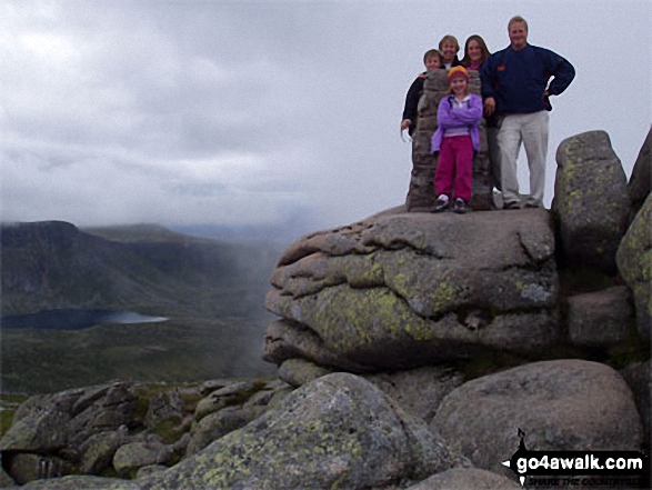 The summit of Lochnagar (Cac Carn Beag) the highest point in the The East Mounth - Glen Shee and Mount Keen to Montrose region of Scotland
Photo: Garry Mitchell
| 14 | Munros | |
| 5 | Corbetts | |
| 6 | Grahams | |
| 0 | Donalds | |
| 20 | Murdos | |
| 26 | Marilyns | |
| 13 | Hills (aka Bridgets) and | |
| 26 | Mountains, Tops, Peaks or Hills with a Trig Point on or near the top |
See these 56 Mountains, Tops, Peaks and Hills:-
- On an Interactive Google Map with a list of tops below it.
(makes it easier to locate a particular top) - On a Detailed List in:
Alphabetical Order | Height Order - On one page with 'yet-to-be-bagged' listed 1st
& then 'already-bagged' tops listed 2nd in:
Alphabetical Order | Height Order - On one page with 'already-bagged' tops listed 1st
& then 'yet-to-be-bagged' tops listed 2nd in:
Alphabetical Order | Height Order


