Mynyddoedd Cambria (The Cambrian Mountains) - a fully detailed list of all the Mountains, Peaks, Tops and Hills (Page 1 of 3)
The South Western Area of The South Western Area of Mynyddoedd Cambria (The Cambrian Mountains), Carmarthenshire, Ceredigion and Powys is the area enclosed by:
- the A44 from Aberystwyth to Llangurig to the North; the A470 from Llangurig via Rhayader to Builth Wells to the East;
- the A483 from Builth Wells to Llandovery, and then the Brecon Beacons National Park boundary to Ffairfach to the South East;
- the B4300 from Ffairfach to Caerfyrddin/Carmarthen to the South; the A484 from Caerfyrddin/Carmarthen to Cynwy Elfed, the B4333 to Newcastle Emlyn and then the A484 to Ceredigion/Cardigan to the South West;
- the Irish Sea from Ceredigion/Cardigan to Aberystwyth to the West;
If you include all the Mountains (Hewitts), the Deweys, the Nuttalls, the Marilyns, the Bridgets (Hills) and all the Mountains, Tops, Peaks and Hills with a Trig Point on them there are 66 tops to climb, bag & conquer and the highest point is Drygarn Fawr at 645m (2,116ft).
To see these Mountains, Peaks, Tops and Hills displayed in different ways - see the options in the left-hand column and towards the bottom of this page.
![]() Your Personal Bagging Record for The South Western Area of The South Western Area of Mynyddoedd Cambria (The Cambrian Mountains)
Your Personal Bagging Record for The South Western Area of The South Western Area of Mynyddoedd Cambria (The Cambrian Mountains)
LOG ON and RELOAD this page to show which Mountains, Peaks, Tops and Hills you have already climbed, bagged & conquered [. . . more details]
See this list in: Alphabetical Order‡
| Height Order
To reverse the order select the link again.
Mountain, Peak, Top or Hill:
Bagged

![]()
1. Y Garth
433m (1,421ft)
Y Garth is on interactive maps:
|

![]()
2. Y Gamriw
604m (1,982ft)
Y Gamriw is on interactive maps:
Y Gamriw is on downloadable PDF you can Print or Save to your Phone: |

![]()
3. Taliaris Hill
291m (955ft)
Taliaris Hill is on interactive maps:
|

![]()
4. Rhos Ymryson
327m (1,073ft)
Rhos Ymryson is on interactive maps:
A downloadable go4awalk.com PDF Peak Bagging Map featuring Rhos Ymryson will be available soon. |

![]()
5. Priddellau (Esgair Nantybeddau)
533m (1,749ft)
Send it in and we'll publish it here.
Priddellau (Esgair Nantybeddau) is on interactive maps:
A downloadable go4awalk.com PDF Peak Bagging Map featuring Priddellau (Esgair Nantybeddau) will be available soon. |
![]()
6. Penrhiw-wen
510m (1,673ft)
Penrhiw-wen is on interactive maps:
A downloadable go4awalk.com PDF Peak Bagging Map featuring Penrhiw-wen will be available soon. |

![]()
7. Pen-crug-melyn (Lan)
326m (1,070ft)
Send it in and we'll publish it here.
Pen-crug-melyn (Lan) is on interactive maps:
A downloadable go4awalk.com PDF Peak Bagging Map featuring Pen-crug-melyn (Lan) will be available soon. |
![]()
8. Pen y Garn-goch
487m (1,598ft)
Pen y Garn-goch is on interactive maps:
A downloadable go4awalk.com PDF Peak Bagging Map featuring Pen y Garn-goch will be available soon. |

![]()
9. Pen y Garn (Bryn Garw)
611m (2,002ft)
Pen y Garn (Bryn Garw) is on interactive maps:
A downloadable go4awalk.com PDF Peak Bagging Map featuring Pen y Garn (Bryn Garw) will be available soon. |
![]()
10. Pen Lan-fawr
526m (1,726ft)
Pen Lan-fawr is on interactive maps:
A downloadable go4awalk.com PDF Peak Bagging Map featuring Pen Lan-fawr will be available soon. |
![]()
11. Pant-llwyd
549m (1,801ft)
Pant-llwyd is on interactive maps:
A downloadable go4awalk.com PDF Peak Bagging Map featuring Pant-llwyd will be available soon. |
![]()
12. Mynydd Trawsnant
517m (1,696ft)
Mynydd Trawsnant is on interactive maps:
A downloadable go4awalk.com PDF Peak Bagging Map featuring Mynydd Trawsnant will be available soon. |
![]()
13. Mynydd Trawsnant
517m (1,696ft)
Mynydd Trawsnant is on interactive maps:
|
![]()
14. Mynydd Pencarreg (Mynydd Pen Carreg)
415m (1,362ft)
Send it in and we'll publish it here.
Mynydd Pencarreg (Mynydd Pen Carreg) is on interactive maps:
A downloadable go4awalk.com PDF Peak Bagging Map featuring Mynydd Pencarreg (Mynydd Pen Carreg) will be available soon. |
![]()
15. Mynydd Llanybyther
408m (1,339ft)
Mynydd Llanybyther is on interactive maps:
|
![]()
16. Mynydd Llansadwrn
345m (1,132ft)
Mynydd Llansadwrn is on interactive maps:
|
![]()
17. Mynydd Figyn
328m (1,076ft)
Mynydd Figyn is on interactive maps:
A downloadable go4awalk.com PDF Peak Bagging Map featuring Mynydd Figyn will be available soon. |
![]()
18. Mynydd Figyn
328m (1,076ft)
Mynydd Figyn is on interactive maps:
|
![]()
19. Mynydd Cynros
329m (1,080ft)
Mynydd Cynros is on interactive maps:
A downloadable go4awalk.com PDF Peak Bagging Map featuring Mynydd Cynros will be available soon. |
![]()
20. Moelfryn (Cerrig Cochion)
522m (1,713ft)
Send it in and we'll publish it here.
Moelfryn (Cerrig Cochion) is on interactive maps:
A downloadable go4awalk.com PDF Peak Bagging Map featuring Moelfryn (Cerrig Cochion) will be available soon. |
![]()
21. Moel Bylchau
396m (1,299ft)
Moel Bylchau is on interactive maps:
|
![]()
22. Llyn Du (Mynydd Tywi) (East Top)
545m (1,788ft)
Send it in and we'll publish it here.
Llyn Du (Mynydd Tywi) (East Top) is on interactive maps:
A downloadable go4awalk.com PDF Peak Bagging Map featuring Llyn Du (Mynydd Tywi) (East Top) will be available soon. |
![]()
23. Llyn Du (Mynydd Tywi)
548m (1,798ft)
Send it in and we'll publish it here.
Llyn Du (Mynydd Tywi) is on interactive maps:
A downloadable go4awalk.com PDF Peak Bagging Map featuring Llyn Du (Mynydd Tywi) will be available soon. |
![]()
24. Llechwedd Ddu (Carnbwlchcloddiau)
559m (1,834ft)
Send it in and we'll publish it here.
Llechwedd Ddu (Carnbwlchcloddiau) is on interactive maps:
A downloadable go4awalk.com PDF Peak Bagging Map featuring Llechwedd Ddu (Carnbwlchcloddiau) will be available soon. |

![]()
25. Llan Ddu Fawr (Waun Claerddu)
594m (1,949ft)
Send it in and we'll publish it here.
Llan Ddu Fawr (Waun Claerddu) is on interactive maps:
A downloadable go4awalk.com PDF Peak Bagging Map featuring Llan Ddu Fawr (Waun Claerddu) will be available soon. |
![]()
26. Lan Ddu Cilwenau
328m (1,076ft)
Lan Ddu Cilwenau is on interactive maps:
|
![]()
27. Hafod Ithel
361m (1,185ft)
Hafod Ithel is on interactive maps:
A downloadable go4awalk.com PDF Peak Bagging Map featuring Hafod Ithel will be available soon. |

![]()
28. Gorllwyn (Pen y Gorllwyn)
613m (2,012ft)
Gorllwyn (Pen y Gorllwyn) is on interactive maps:
A downloadable go4awalk.com PDF Peak Bagging Map featuring Gorllwyn (Pen y Gorllwyn) will be available soon. |
![]()
29. Gopa Uchaf
509m (1,670ft)
Gopa Uchaf is on interactive maps:
A downloadable go4awalk.com PDF Peak Bagging Map featuring Gopa Uchaf will be available soon. |
![]()
30. Geifas
572m (1,877ft)
Geifas is on interactive maps:
A downloadable go4awalk.com PDF Peak Bagging Map featuring Geifas will be available soon. |
View these 66 Mountains, Peaks, Tops and Hills:
- On an Interactive Google Map (loads faster)
- On an Interactive Google Map with a list of tops below it.
(makes it easier to locate a particular top) - On a Detailed List in:
Alphabetical Order | Height Order - On one page with 'yet-to-be-bagged' listed 1st & then 'already-bagged' tops listed 2nd in:
Alphabetical Order | Height Order - On one page with 'already-bagged' tops listed 1st & then 'yet-to-be-bagged' tops listed 2nd in:
Alphabetical Order | Height Order
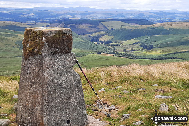
 Drygarn Fawr in The South Western Area of Mynyddoedd Cambria (The Cambrian Mountains)
Photo: Colin France
Is there a Mountain, Peak, Top or Hill missing from the above google map or list?
Let us know an we will add it to our database.

To contribute to go4awalk.com or to contact us about anything at all - see Talk To Us.
For help see Help.
go4awalk.com and go4awalk.co.uk are registered trademarks of TMDH Limited.
Copyright © 2000-2025 TMDH Limited. All rights reserved.
Copyright Terms & Conditions Privacy Statement
A - Z Walks Home Log On/Accounts Photo Gallery Walk Ideas and Collections Fell Facts Hill Skills Walking Questions and Answers Your Stories News Competitions Product Reviews/Gear Tests Walking Gear Guides Peaks and Mountains Peak Bagging Find New Walking Friends Camping GPS Waypoints for Walking Contents Walk Search Talk To Us go4awalk.com Help Free Example Walks Newsletter


