The Mountains, Peaks, Tops and Hills in South West of with all the tops you are yet to climb first & then the ones you have already bagged in second.
South West of region of England comprises the traditional counties of Cornwall, Devon, Somerset and Dorset and includes Dartmoor National Park and Exmoor National Park.
If you include all the Mountains (Hewitts), the Deweys, the Nuttalls, the Marilyns, the Bridgets (Hills) and all the Mountains, Tops, Peaks and Hills with a Trig Point on them there are 123 tops to climb, bag & conquer and the highest point is High Willhays at 622m (2,041ft).
To see these Mountains, Peaks, Tops and Hills displayed in different ways - see the options in the left-hand column and towards the bottom of this page.
![]() Your Personal Bagging Record for South West of
Your Personal Bagging Record for South West of
When logged on, you can mark each Mountain, Peak, Top or Hill as 'bagged' by either:
- if you opt to display the tops in this area using a google map, click or tap on its symbol on the map below. This will open a text window. Click or tap on the 'Record [mountain name] as Bagged, Climbed & Conquered' link towards the bottom of the text window, or
- if you opt to display the tops in this area as a list, click or tap on the red 'not yet' symbol to the right of the name of each 'top'
Either method will open a new page where you can complete all your details such as:
- when you bagged the Mountain, Peak, Top or Hill;
- which route you took
- who you went with
- what the weather was like
- any other comment that will remind you of the day
Once you have completed your details and click or tap the submit button, you will automatically return to this page and the top you bagged will show with a green tick.
NB. None of the above fields are 'mandatory' - you can leave them blank if you wish.
NNB. You also have the option whether to display your peak bagging exploits to other users of this site or keep them private so only you can see them when you are logged on.
Furthermore, since you can also access your Personal Mountain & Hill Bagging Record via go4awalk Mobile you can quickly & easily record, edit and view your achievements - whether you are at home/work on your desktop computer or in the pub/at the top of a mountain with your Mobile Phone. (You can even download your Personal Mountain & Hill Bagging Record as a .csv file for importing into and saving with spreadsheet software like Excel or NeoOffice!)
This facility costs one credit to initially access your personal bagging record. Once accessed, all other interactions, such as recording other Mountains, Peaks, Tops and Hills as 'bagged' or altering an existing bagging record, are free.
Click REGISTER to register and purchase credits.
LOG ON and RELOAD this page to show which Mountains, Peaks, Tops and Hills you have already climbed, bagged & conquered. [ . . . remove this text]
Scroll down this list of mountains, peaks, tops & hills below and tap/click on each name (in blue) to locate it on the map above.
See this list in: Alphabetical Order‡ | Height Order
To reverse the order select the link again.
Top yet to be climbed, bagged & conquered:
Bagged

![]()
1. Yes Tor
619m (2031ft)
Nuttall and Trig Point
See more details, photos, trip reports and easy-to-follow walks up Yes Tor

![]()
2. Worlebury Hill
109m (357ft)
Bridget
See more details, photos, trip reports and easy-to-follow walks up Worlebury Hill
![]()
3. Woodbury Castle (Woodbury Common)
183m (600ft)
Bridget
See more details, photos, trip reports and easy-to-follow walks up Woodbury Castle (Woodbury Common)

![]()
4. Wills Neck (Bagborough Hill)
386m (1266ft)
Marilyn and Trig Point
See more details, photos, trip reports and easy-to-follow walks up Wills Neck (Bagborough Hill)
![]()
5. Wigford Down
273m (895ft)
Bridget
See more details, photos, trip reports and easy-to-follow walks up Wigford Down
![]()
6. White Tor
468m (1535ft)
Bridget
See more details, photos, trip reports and easy-to-follow walks up White Tor

![]()
7. White Ridge
506m (1660ft)
Dewey
See more details, photos, trip reports and easy-to-follow walks up White Ridge
![]()
8. White Down (White Down Copse)
167m (548ft)
Bridget
See more details, photos, trip reports and easy-to-follow walks up White Down (White Down Copse)
![]()
9. Weston Down
112m (368ft)
Bridget
See more details, photos, trip reports and easy-to-follow walks up Weston Down

![]()
10. Wavering Down
211m (692ft)
Bridget and Trig Point
See more details, photos, trip reports and easy-to-follow walks up Wavering Down
![]()
11. Watch Croft (White Downs)
252m (827ft)
Marilyn and Trig Point
See more details, photos, trip reports and easy-to-follow walks up Watch Croft (White Downs)
![]()
12. Waddles Down
248m (813ft)
Bridget and Trig Point
See more details, photos, trip reports and easy-to-follow walks up Waddles Down
![]()
13. Ugborough Beacon
378m (1240ft)
Bridget
See more details, photos, trip reports and easy-to-follow walks up Ugborough Beacon
![]()
14. Tregonning Hill
194m (636ft)
Bridget and Trig Point
See more details, photos, trip reports and easy-to-follow walks up Tregonning Hill
![]()
15. Top Tor
432m (1417ft)
Bridget
See more details, photos, trip reports and easy-to-follow walks up Top Tor
![]()
16. Three Barrows (Ugborough Moor)
464m (1522ft)
Bridget and Trig Point
See more details, photos, trip reports and easy-to-follow walks up Three Barrows (Ugborough Moor)
![]()
17. The Verne (Portland Bill)
149m (489ft)
Bridget
See more details, photos, trip reports and easy-to-follow walks up The Verne (Portland Bill)
![]()
18. The Beacon (Corton Hill)
196m (643ft)
Bridget and Trig Point
See more details, photos, trip reports and easy-to-follow walks up The Beacon (Corton Hill)
![]()
19. Telegraph Hill (Minterne Magna)
267m (876ft)
Bridget
See more details, photos, trip reports and easy-to-follow walks up Telegraph Hill (Minterne Magna)
![]()
20. Swyre Head
208m (682ft)
Bridget and Trig Point
See more details, photos, trip reports and easy-to-follow walks up Swyre Head
![]()
21. Stoke Hill
162m (531ft)
Bridget
See more details, photos, trip reports and easy-to-follow walks up Stoke Hill
![]()
22. Steeperton Tor
532m (1746ft)
Dewey
See more details, photos, trip reports and easy-to-follow walks up Steeperton Tor
![]()
23. Staple Hill
315m (1033ft)
Marilyn and Trig Point
See more details, photos, trip reports and easy-to-follow walks up Staple Hill
![]()
24. Stalldown Barrow
415m (1362ft)
Bridget
See more details, photos, trip reports and easy-to-follow walks up Stalldown Barrow
![]()
25. St Rayn Hill
238m (781ft)
Bridget and Trig Point
See more details, photos, trip reports and easy-to-follow walks up St Rayn Hill
![]()
26. South Hessary Tor
450m (1476ft)
Bridget
See more details, photos, trip reports and easy-to-follow walks up South Hessary Tor
![]()
27. Sourton Tors
440m (1444ft)
Bridget and Trig Point
See more details, photos, trip reports and easy-to-follow walks up Sourton Tors
![]()
28. Sittaford Tor
538m (1765ft)
Bridget
See more details, photos, trip reports and easy-to-follow walks up Sittaford Tor
![]()
29. Sheeps Tor (Yellowmead Down)
369m (1211ft)
Bridget
See more details, photos, trip reports and easy-to-follow walks up Sheeps Tor (Yellowmead Down)
![]()
30. Sharpitor (Peek Hill)
401m (1316ft)
Bridget
See more details, photos, trip reports and easy-to-follow walks up Sharpitor (Peek Hill)
![]()
31. Sharp Tor
380m (1247ft)
Bridget
See more details, photos, trip reports and easy-to-follow walks up Sharp Tor
![]()
32. Shaptor Rock (Shaptor Down)
268m (879ft)
Bridget
See more details, photos, trip reports and easy-to-follow walks up Shaptor Rock (Shaptor Down)
![]()
33. Selworthy Beacon
308m (1010ft)
Marilyn and Trig Point
See more details, photos, trip reports and easy-to-follow walks up Selworthy Beacon

![]()
34. Ryder's Hill
515m (1690ft)
Dewey and Trig Point
See more details, photos, trip reports and easy-to-follow walks up Ryder's Hill
![]()
35. Roos Tor
454m (1490ft)
Bridget
See more details, photos, trip reports and easy-to-follow walks up Roos Tor
![]()
36. Rippon Tor
473m (1552ft)
Bridget and Trig Point
See more details, photos, trip reports and easy-to-follow walks up Rippon Tor
![]()
37. Ridgeway Hill
198m (653ft)
Bridget
See more details, photos, trip reports and easy-to-follow walks up Ridgeway Hill
![]()
38. Riddon Ridge
380m (1247ft)
Bridget
See more details, photos, trip reports and easy-to-follow walks up Riddon Ridge
![]()
39. Quickbeam Hill
481m (1578ft)
Bridget
See more details, photos, trip reports and easy-to-follow walks up Quickbeam Hill
![]()
40. Prestonbury Common
249m (817ft)
Bridget
See more details, photos, trip reports and easy-to-follow walks up Prestonbury Common
![]()
41. Periton Hill
297m (974ft)
Marilyn and Trig Point
See more details, photos, trip reports and easy-to-follow walks up Periton Hill
![]()
42. Pepperdon Down
353m (1158ft)
Bridget
See more details, photos, trip reports and easy-to-follow walks up Pepperdon Down
![]()
43. Penhale Hill
179m (587ft)
Bridget
See more details, photos, trip reports and easy-to-follow walks up Penhale Hill
![]()
44. North Hessary Tor
517m (1696ft)
Dewey and Trig Point
See more details, photos, trip reports and easy-to-follow walks up North Hessary Tor
![]()
45. Nine Barrow Down (Coringdon)
199m (653ft)
Marilyn and Trig Point
See more details, photos, trip reports and easy-to-follow walks up Nine Barrow Down (Coringdon)
![]()
46. Natterdon Common
333m (1092ft)
Bridget
See more details, photos, trip reports and easy-to-follow walks up Natterdon Common
![]()
47. Monkham Hill (Withycombe Common)
382m (1253ft)
Bridget and Trig Point
See more details, photos, trip reports and easy-to-follow walks up Monkham Hill (Withycombe Common)
![]()
48. Meldon Hill (Dartmoor)
390m (1279ft)
Bridget and Trig Point
See more details, photos, trip reports and easy-to-follow walks up Meldon Hill (Dartmoor)
![]()
49. Mardon Down
356m (1168ft)
Bridget
See more details, photos, trip reports and easy-to-follow walks up Mardon Down
![]()
50. Lyscombe Hill
262m (859ft)
Bridget
See more details, photos, trip reports and easy-to-follow walks up Lyscombe Hill
![]()
51. Lype Hill
423m (1388ft)
Bridget and Trig Point
See more details, photos, trip reports and easy-to-follow walks up Lype Hill
![]()
52. Loxton Hill (Bleadon Hill)
176m (577ft)
Bridget and Trig Point
See more details, photos, trip reports and easy-to-follow walks up Loxton Hill (Bleadon Hill)

![]()
53. Lewesdon Hill
279m (915ft)
Marilyn
See more details, photos, trip reports and easy-to-follow walks up Lewesdon Hill
![]()
54. Leedon Tor
389m (1276ft)
Bridget
See more details, photos, trip reports and easy-to-follow walks up Leedon Tor
![]()
55. Lee Moor (Penn Moor)
492m (1614ft)
Bridget and Trig Point
See more details, photos, trip reports and easy-to-follow walks up Lee Moor (Penn Moor)
![]()
56. Laployd Hill
323m (1060ft)
Bridget
See more details, photos, trip reports and easy-to-follow walks up Laployd Hill
![]()
57. Lambert's Castle Hill
256m (840ft)
Bridget and Trig Point
See more details, photos, trip reports and easy-to-follow walks up Lambert's Castle Hill
![]()
58. Kitty Tor (Amicombe Hill)
585m (1919ft)
Dewey
See more details, photos, trip reports and easy-to-follow walks up Kitty Tor (Amicombe Hill)
![]()
59. Kit Hill
334m (1096ft)
Marilyn and Trig Point
See more details, photos, trip reports and easy-to-follow walks up Kit Hill
![]()
60. Kilmar Tor (Twelve Men's Moor)
390m (1279ft)
Bridget and Trig Point
See more details, photos, trip reports and easy-to-follow walks up Kilmar Tor (Twelve Men's Moor)
![]()
61. Kestor Rock (Changford Common)
437m (1434ft)
Bridget
See more details, photos, trip reports and easy-to-follow walks up Kestor Rock (Changford Common)
![]()
62. Hunter's Tor
326m (1069ft)
Bridget
See more details, photos, trip reports and easy-to-follow walks up Hunter's Tor
![]()
63. Hound Tor (Bonehill Down)
414m (1358ft)
Bridget
See more details, photos, trip reports and easy-to-follow walks up Hound Tor (Bonehill Down)
![]()
64. Hoodown
179m (587ft)
Bridget and Trig Point
See more details, photos, trip reports and easy-to-follow walks up Hoodown
![]()
65. Holne Chase
198m (649ft)
Bridget
See more details, photos, trip reports and easy-to-follow walks up Holne Chase
![]()
66. Higher White Tor
525m (1723ft)
Dewey
See more details, photos, trip reports and easy-to-follow walks up Higher White Tor

![]()
67. High Willhays
622m (2041ft)
Mountain (Hewitt), Nuttall and Marilyn
See more details, photos, trip reports and easy-to-follow walks up High Willhays
![]()
68. Hensbarrow Beacon
312m (1023ft)
Marilyn and Trig Point
See more details, photos, trip reports and easy-to-follow walks up Hensbarrow Beacon
![]()
69. Heltor Rock
312m (1023ft)
Bridget
See more details, photos, trip reports and easy-to-follow walks up Heltor Rock
![]()
70. Haytor Rocks
457m (1499ft)
Bridget
See more details, photos, trip reports and easy-to-follow walks up Haytor Rocks
![]()
71. Hayne Down (Bowerman's Nose)
391m (1283ft)
Bridget
See more details, photos, trip reports and easy-to-follow walks up Hayne Down (Bowerman's Nose)
![]()
72. Hardown Hill
207m (679ft)
Marilyn
See more details, photos, trip reports and easy-to-follow walks up Hardown Hill
![]()
73. Hangingstone Hill (Dartmoor)
603m (1979ft)
Dewey
See more details, photos, trip reports and easy-to-follow walks up Hangingstone Hill (Dartmoor)
![]()
74. Hanger Down
233m (764ft)
Bridget
See more details, photos, trip reports and easy-to-follow walks up Hanger Down
![]()
75. Hameldown Tor (Hamel Down)
532m (1746ft)
Dewey and Trig Point
See more details, photos, trip reports and easy-to-follow walks up Hameldown Tor (Hamel Down)
![]()
76. Hambledon Hill
192m (630ft)
Bridget and Trig Point
See more details, photos, trip reports and easy-to-follow walks up Hambledon Hill
![]()
77. Hadborough (Haddon Hill)
355m (1165ft)
Bridget and Trig Point
See more details, photos, trip reports and easy-to-follow walks up Hadborough (Haddon Hill)
![]()
78. Gutter Tor (Ringmoor Down)
350m (1148ft)
Bridget and Trig Point
See more details, photos, trip reports and easy-to-follow walks up Gutter Tor (Ringmoor Down)
![]()
79. Gripper's Hill
398m (1306ft)
Bridget
See more details, photos, trip reports and easy-to-follow walks up Gripper's Hill
![]()
80. Great Staple Tor
455m (1493ft)
Bridget
See more details, photos, trip reports and easy-to-follow walks up Great Staple Tor
![]()
81. Great Mis Tor
539m (1768ft)
Dewey
See more details, photos, trip reports and easy-to-follow walks up Great Mis Tor
![]()
82. Great Links Tor
587m (1926ft)
Dewey and Trig Point
See more details, photos, trip reports and easy-to-follow walks up Great Links Tor
![]()
83. Great Hill (Torquay)
180m (590ft)
Bridget and Trig Point
See more details, photos, trip reports and easy-to-follow walks up Great Hill (Torquay)
![]()
84. Gogwell Farm (Bingwell Hill)
237m (777ft)
Bridget and Trig Point
See more details, photos, trip reports and easy-to-follow walks up Gogwell Farm (Bingwell Hill)
![]()
85. Glastonbury Tor
158m (518ft)
Bridget and Trig Point
See more details, photos, trip reports and easy-to-follow walks up Glastonbury Tor
![]()
86. Gibbet Hill (Dartmoor)
353m (1158ft)
Bridget and Trig Point
See more details, photos, trip reports and easy-to-follow walks up Gibbet Hill (Dartmoor)
![]()
87. Fursdon Hill
254m (833ft)
Bridget
See more details, photos, trip reports and easy-to-follow walks up Fursdon Hill
![]()
88. Failand Hill
164m (538ft)
Bridget
See more details, photos, trip reports and easy-to-follow walks up Failand Hill
![]()
89. Eggardon Hill
252m (827ft)
Bridget and Trig Point
See more details, photos, trip reports and easy-to-follow walks up Eggardon Hill
![]()
90. Easdon Tor
439m (1440ft)
Bridget and Trig Point
See more details, photos, trip reports and easy-to-follow walks up Easdon Tor

![]()
91. Dunkery Beacon
519m (1703ft)
Dewey, Marilyn and Trig Point
See more details, photos, trip reports and easy-to-follow walks up Dunkery Beacon
![]()
92. Dundry (Dundry Down)
233m (764ft)
Marilyn and Trig Point
See more details, photos, trip reports and easy-to-follow walks up Dundry (Dundry Down)
![]()
93. Cut Hill
603m (1979ft)
Dewey and Trig Point
See more details, photos, trip reports and easy-to-follow walks up Cut Hill
![]()
94. Cranbook Castle (Uppacott Down)
337m (1106ft)
Bridget
See more details, photos, trip reports and easy-to-follow walks up Cranbook Castle (Uppacott Down)
![]()
95. Cox Tor
442m (1450ft)
Bridget and Trig Point
See more details, photos, trip reports and easy-to-follow walks up Cox Tor
![]()
96. Cosdon Hill (Cawsand Hill)
551m (1808ft)
Dewey and Trig Point
See more details, photos, trip reports and easy-to-follow walks up Cosdon Hill (Cawsand Hill)
![]()
97. Corndon Tor
434m (1424ft)
Bridget
See more details, photos, trip reports and easy-to-follow walks up Corndon Tor
![]()
98. Colleywell Top
253m (830ft)
Bridget
See more details, photos, trip reports and easy-to-follow walks up Colleywell Top
![]()
99. Christ Cross
261m (856ft)
Marilyn and Trig Point
See more details, photos, trip reports and easy-to-follow walks up Christ Cross
![]()
100. Chinkwell Tor
452m (1483ft)
Bridget
See more details, photos, trip reports and easy-to-follow walks up Chinkwell Tor
![]()
101. Carnmenellis
252m (827ft)
Marilyn and Trig Point
See more details, photos, trip reports and easy-to-follow walks up Carnmenellis
![]()
102. Butterdon Hill
365m (1197ft)
Bridget and Trig Point
See more details, photos, trip reports and easy-to-follow walks up Butterdon Hill
![]()
103. Butterdon Down
351m (1151ft)
Bridget
See more details, photos, trip reports and easy-to-follow walks up Butterdon Down
![]()
104. Bulverton Hill
212m (695ft)
Bridget
See more details, photos, trip reports and easy-to-follow walks up Bulverton Hill
![]()
105. Bulbarrow Hill
274m (899ft)
Bridget and Trig Point
See more details, photos, trip reports and easy-to-follow walks up Bulbarrow Hill
![]()
106. Brown Willy
420m (1378ft)
Marilyn and Trig Point
See more details, photos, trip reports and easy-to-follow walks up Brown Willy
![]()
107. Brent Tor
334m (1096ft)
Bridget and Trig Point
See more details, photos, trip reports and easy-to-follow walks up Brent Tor
![]()
108. Brent Knoll
139m (456ft)
Bridget and Trig Point
See more details, photos, trip reports and easy-to-follow walks up Brent Knoll
![]()
109. Brent Hill (Beara Common)
311m (1020ft)
Bridget and Trig Point
See more details, photos, trip reports and easy-to-follow walks up Brent Hill (Beara Common)
![]()
110. Blackingstone Rock
355m (1165ft)
Bridget
See more details, photos, trip reports and easy-to-follow walks up Blackingstone Rock
![]()
111. Black Hill (Quantocks)
358m (1174ft)
Bridget and Trig Point
See more details, photos, trip reports and easy-to-follow walks up Black Hill (Quantocks)
![]()
112. Black Hill (Dartmoor)
412m (1352ft)
Bridget
See more details, photos, trip reports and easy-to-follow walks up Black Hill (Dartmoor)
![]()
113. Black Down (Hardy Monument)
239m (784ft)
Bridget and Trig Point
See more details, photos, trip reports and easy-to-follow walks up Black Down (Hardy Monument)
![]()
114. Bin Down
200m (656ft)
Bridget and Trig Point
See more details, photos, trip reports and easy-to-follow walks up Bin Down
![]()
115. Belstone Tor
479m (1572ft)
Bridget
See more details, photos, trip reports and easy-to-follow walks up Belstone Tor
![]()
116. Bellever Tor
443m (1453ft)
Bridget and Trig Point
See more details, photos, trip reports and easy-to-follow walks up Bellever Tor
![]()
117. Beardown Tors
512m (1680ft)
Dewey
See more details, photos, trip reports and easy-to-follow walks up Beardown Tors
![]()
118. Beacon Hill (Quantocks)
310m (1017ft)
Bridget and Trig Point
See more details, photos, trip reports and easy-to-follow walks up Beacon Hill (Quantocks)
![]()
119. Beacon Hill (Lundy)
142m (466ft)
Bridget
See more details, photos, trip reports and easy-to-follow walks up Beacon Hill (Lundy)
![]()
120. Beacon Hill (Buttshill Cross)
196m (643ft)
Bridget and Trig Point
See more details, photos, trip reports and easy-to-follow walks up Beacon Hill (Buttshill Cross)
![]()
121. Beacon Batch (Mendip Hills)
325m (1066ft)
Marilyn and Trig Point
See more details, photos, trip reports and easy-to-follow walks up Beacon Batch (Mendip Hills)
![]()
122. Bathford Hil
205m (672ft)
Bridget and Trig Point
See more details, photos, trip reports and easy-to-follow walks up Bathford Hil
![]()
123. Auswell Rocks
325m (1066ft)
Bridget
See more details, photos, trip reports and easy-to-follow walks up Auswell Rocks
Mountain, Peak, Top or Hill already bagged:
Bagged
![]() Your Personal Bagging Record for South West of
Your Personal Bagging Record for South West of
When logged on, you can mark each Mountain, Peak, Top or Hill as 'bagged' by either:
- if you opt to display the tops in this area using a google map, click or tap on its symbol on the map below. This will open a text window. Click or tap on the 'Record [mountain name] as Bagged, Climbed & Conquered' link towards the bottom of the text window, or
- if you opt to display the tops in this area as a list, click or tap on the red 'not yet' symbol to the right of the name of each 'top'
Either method will open a new page where you can complete all your details such as:
- when you bagged the Mountain, Peak, Top or Hill;
- which route you took
- who you went with
- what the weather was like
- any other comment that will remind you of the day
Once you have completed your details and click or tap the submit button, you will automatically return to this page and the top you bagged will show with a green tick.
NB. None of the above fields are 'mandatory' - you can leave them blank if you wish.
NNB. You also have the option whether to display your peak bagging exploits to other users of this site or keep them private so only you can see them when you are logged on.
Furthermore, since you can also access your Personal Mountain & Hill Bagging Record via go4awalk Mobile you can quickly & easily record, edit and view your achievements - whether you are at home/work on your desktop computer or in the pub/at the top of a mountain with your Mobile Phone. (You can even download your Personal Mountain & Hill Bagging Record as a .csv file for importing into and saving with spreadsheet software like Excel or NeoOffice!)
This facility costs one credit to initially access your personal bagging record. Once accessed, all other interactions, such as recording other Mountains, Peaks, Tops and Hills as 'bagged' or altering an existing bagging record, are free.
Click REGISTER to register and purchase credits.
LOG ON and RELOAD this page to show which Mountains, Peaks, Tops and Hills you have already climbed, bagged & conquered. [ . . . remove this text]
View these 123 Mountains, Peaks, Tops and Hills:
- On an Interactive Google Map (loads faster)
- On an Interactive Google Map with a list of tops below it.
(makes it easier to locate a particular top) - On a Detailed List in:
Alphabetical Order | Height Order - On one page with 'yet-to-be-bagged' listed 1st & then 'already-bagged' tops listed 2nd in:
Alphabetical Order | Height Order - On one page with 'already-bagged' tops listed 1st & then 'yet-to-be-bagged' tops listed 2nd in:
Alphabetical Order | Height Order
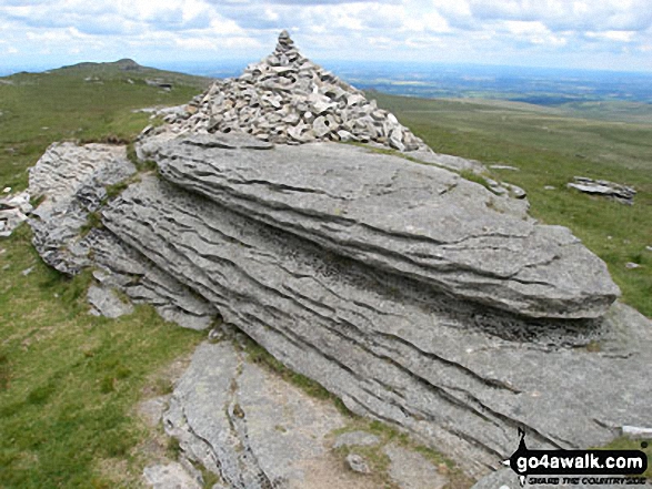 The summit of High Willhays in South West
Photo: David Rodgers
Is there a Mountain, Peak, Top or Hill missing from the above google map or list?


