UK Postcode SA62 - The 30 nearest easy-to-follow, circular walk route maps to you
The thirty nearest easy-to-follow, circular walk route maps to you in UK Postcode SA62 in Walk Grade Order
The UK cities, towns and villages in Pembrokeshire, Wales that have SA62 in their UK Postcode include:
• Abercastle • Abereiddy • Ambleston • Berea • Boulston • Brawdy • Broad Haven • Broadway • Caer Farchell • Camrose • Castle Morris • Castlebythe • Croesgoch • Crundale • Dale • Dreenhill • Druidston • Folly • Ford • Freystrop Cross • Granston • Greenway • Haroldston West • Hasguard • Hayscastle • Hayscastle Cross • Hook • Johnston • Jordanston • Keeston • Lambston • Letterston • Leweston • Little Haven • Little Newcastle • Llandeloy • Llangwm • Llanreithan • Llanrhian • Llethr • Lower Freystrop • Marloes • Mathry • Middle Mill • Mountain Water • Newbridge • Newgale • Newton • Nolton • North Johnston • Pelcomb Bridge • Pelcomb Cross • Penycwm • Pope Hill • Portfield Gate • Porthgain • Poyston Cross • Puncheston • Ratford Bridge • Rhodiad • Rhosson • Rinaston • Roch • Rosepool • Rudbaxton • Sandy Haven • Scolton • Solva • Spittal • St Brides • St David's • St Dogwells • St Ishmael's • Sutton • Talbenny • Tangiers • The Rhos • Tiers Cross • Trecwn • Tre-ddiog • Treffgarne • Treffynnon • Trefgarn Owen • Treglemais • Treleddyd-fawr • Tretio • Trevine • Uzmaston • Wallis • Walton West • Walwyns Castle • Welsh Hook • Whitchurch • Wiston • Wolf's Castle • Wolfsdale •
Not familiar with the area around SA62?
See these 30 nearest walks to UK Postcode SA62 on a google map
   |
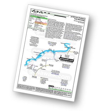
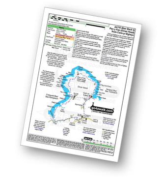
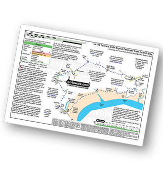
Vital Statistics:
| Length: | 10.75 miles (17 km) |
| Ascent: | 1,748ft (533m) |
| Time: | 5.75hrs |
| Grade: |  |
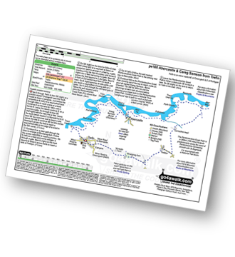
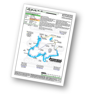
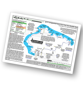
Route Summary:
Trefin - Rhoslanog-fach - Mynedd-hwnt - Trefelyn - Carnachen-lwyd Farm - Mynydd Morfa - The Pembrokeshire Coast Path - Aber Mawr - Penmorfa - Trwyn Llwynog - Porth Glastwr - Pwllstrodur - Aber Yw - Ynys y Castell - Abercastle - Careg Samson (Burial Chamber) - Pwll Whiting - Pwll Llong - Pwll Olfa - Trwyn Llwyd - Aber Draw - Trefin Mill - Trefin
|
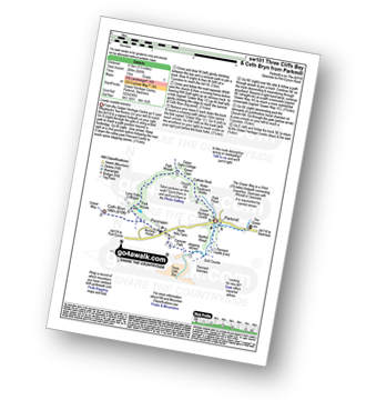
Vital Statistics:
| Length: | 6 miles (9.5 km) |
| Ascent: | 1,086ft (331m) |
| Time: | 3.25hrs |
| Grade: |  |
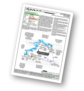
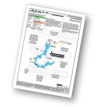
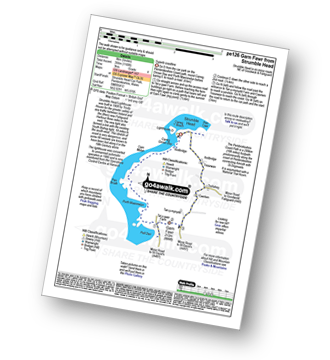
Route Summary:
Trefin - Rhoslanog-fach - Trefelyn - Carnachen-lwyd - The Pembrokeshire Coast Path - Aber Mawr - Penmorfa - Trwyn Llwynog - Porth Glastwr - Pwllstrodur - Aber Yw - Ynys y Castell - Abercastle - Careg Samson (Burial Chamber) - Pwll Whiting - Pwll Llong - Pwll Olfa.
|
Vital Statistics:
| Length: | 4.5 miles (7 km) |
| Ascent: | 686ft (209m) |
| Time: | 2½ hrs |
| Grade: |  |
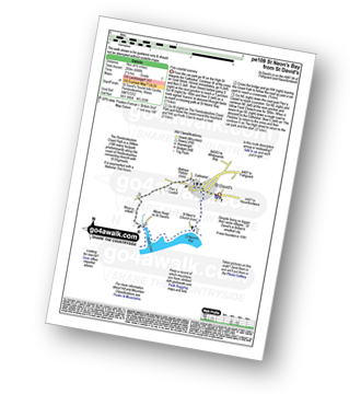
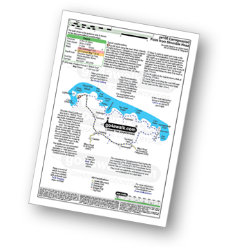
Route Summary:
St David's - St Non's Church - St Non's Bay - The Pembrokeshire Coast Path - Porth Clais - Rhos-y-cribed - Bishops Palace - St David's Cathedral - St David's
|
Vital Statistics:
| Length: | 6.25 miles (10 km) |
| Ascent: | 1,174ft (358m) |
| Time: | 3½ hrs |
| Grade: | |
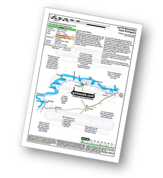
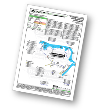
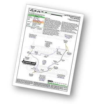
Route Summary:
Porthgain - The Pembrokeshire Coast Path - Porth-gain - Porth Ffynnon - Penclegyr - Porth Dwfn - Porth Egr - Traeth Llyfn - Trwyncastell - Abereiddi Bay - Abereiddy - Portheiddy - Llanrhian' - Swyn-y-Don - Pwll Crochan - Porthgain
|
Vital Statistics:
| Length: | 7.5 miles (11.5 km) |
| Ascent: | 1,427ft (435m) |
| Time: | 4 hrs |
| Grade: |  |
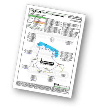
Route Summary:
Abereiddy - The Pembrokeshire Coast Path - Aber-pwll - Stacan Barcucan - Aberdinas - Carreg-gwylan-fach - Carreg-gwylan-fach - Porth y Rhaw - Penclegyr - Carn Pembury - Rhosygilwen - Rhosygilwen Farm - Abereiddy
|
Vital Statistics:
| Length: | 7.25 miles (11.5 km) |
| Ascent: | 1,352ft (412m) |
| Time: | 5 hrs |
| Grade: | |
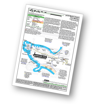
Route Summary:
Marloes - Marloes Beacon - Black Cliff - Musselwick Sands - The Pembrokeshire Coast Path - Howney Stone - High Point - Martin's Haven - Haven Point - Wooltack Point - Mouse's Haven - The Anvil - The Deer Park - Renney Slip - Deadman's Bay - Pitting Gales Point - Rainy Lock - Little Coastle Bay - Victoria Bay - Watery Bay - Albion Sands - Gateholm Island - Raggle Rocks - Marloes Sands - Green Mire Cottage - Marloes
|
Vital Statistics:
| Length: | 6.25 miles (10 km) |
| Ascent: | 1,660ft (506m) |
| Time: | 4 hrs |
| Grade: | |
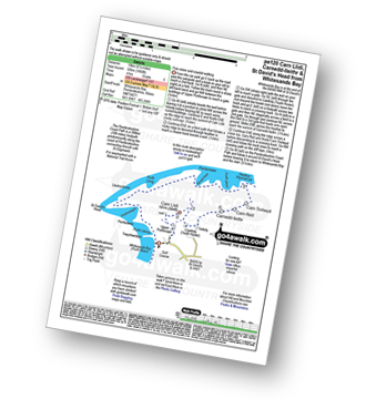
Route Summary:
Whitesands Bay (Porth Mawr) - Upper Porthmawr - Carn Llidi - Trefelly - Carnedd-lleithr - Carn-ffald - Carn Treliwyd - The Pembrokeshire Coast Path - Porth Llong - Llechenhinen - St David's Head - Porthmelgan - Penlledwen - Porth Lleuog - Trwynhwrddyn - Whitesands Bay.
|
Vital Statistics:
| Length: | 3.75 miles (6 km) |
| Ascent: | 1,043ft (318m) |
| Time: | 2½ hrs |
| Grade: | |
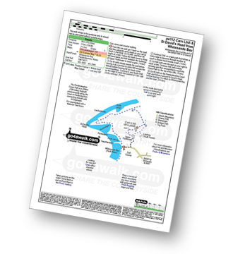
Route Summary:
Whitesands Bay (Porth Mawr) - Upper Porthmawr - Carn Llidi - The Pembrokeshire Coast Path - Porth Llong - Llechenhinen - St David's Head - Porthmelgan - Penlledwen - Porth Lleuog - Trwynhwrddyn - Whitesands Bay.
|
Vital Statistics:
| Length: | 6.25 miles (10 km) |
| Ascent: | 1,138ft (347m) |
| Time: | 3½ hrs |
| Grade: | |
Route Summary:
Porthstinian - The Pembrokeshire Coast Path - St Justinian's Lifeboat Station - Maen Bachaua - Ramsey Sound - Carn Ar Wig - Penmaen Melyn - The Bitches - Pen Dal-aderyn - Porthaflod - Pen Pedol - Porthlysgi Bay - St Brides Bay - Porth Clais - Pen-porth-clais - Rhos-y-cribed - Clegyr-Boia - Waun Rhosson - Rhosson Farm - Rhosson Ganol - Porthstinian
|
Vital Statistics:
| Length: | 3.75 miles (6 km) |
| Ascent: | 699ft (204m) |
| Time: | 2 hrs |
| Grade: | |
Route Summary:
Porthstinian - The Pembrokeshire Coast Path - St Justinian's Lifeboat Station - Maen Bachaua - Ramsey Sound - Carn Ar Wig - Penmaen Melyn - The BItches - Pen Dal-aderyn - Porthaflod - Pen Pedol - Porthlysgi Bay - St Brides Bay - Treginnis-isaf Farm - Porthstinian
|
Vital Statistics:
| Length: | 4.75 miles (8.5 km) |
| Ascent: | 1,007ft (307m) |
| Time: | 3 hrs |
| Grade: | |
Route Summary:
Llanwnda - Cwm Felin - Carregwastad Point - Aber Felin - The Pembrokeshire Coast Path - Pant y Dwr - Porth Maen - Anglas Bay - Pen Anglas - Crincoed Point - Pwll Hir - Goodwick - Llanwnda
|
Vital Statistics:
| Length: | 4.75 miles (7.5 km) |
| Ascent: | 863ft (263m) |
| Time: | 2½ hrs |
| Grade: | |
Route Summary:
Llanwnda - Cwm Felin - Carregwastad Point - The Pembrokeshire Coast Path - Aber Felin - Carn Helen - Y Globa Fawr - Pen Capel Degan - Treneewydd - Garn Folch - Llanwnda
|
Vital Statistics:
| Length: | 8.5 miles (13.5 km) |
| Ascent: | 2,060ft (628m) |
| Time: | 5.25hrs |
| Grade: | |
Route Summary:
Strumble Head - The Pembrokeshire Coast Path - Porthsychan - Carregwastad Point - Aber Felin - Cwm Felin - Garn Folch - Garn Fawr (Strumble Head) - Pwll Deri - Porth Maenmelyn - Pen Brush - Carn Melyn - Carreg Onnen Bay - Strumble Head
|
Vital Statistics:
| Length: | 5 miles (8 km) |
| Ascent: | 1,168ft (356m) |
| Time: | 3 hrs |
| Grade: | |
Route Summary:
Strumble Head - The Pembrokeshire Coast Path - Carreg Onnen Bay - Carn Melyn - Pen Brush - Porth Maenmelyn - Pwll Deri - Garn Fawr (Strumble Head) - Trefisheg - Tresirwen - Strumble Head
|
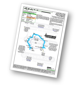
Vital Statistics:
| Length: | 6 miles (9.5 km) |
| Ascent: | 1,187ft (362m) |
| Time: | 3½ hrs |
| Grade: | |
Route Summary:
Strumble Head - The Pembrokeshire Coast Path - Porthsychan - Carregwastad Point - Aber Felin - Cwm Felin - Treneewydd - Trefisheg - Tresirwen - Strumble Head
Not familiar with the area around SA62?
See these 30 nearest walks to UK Postcode SA62 on a google map
|
Vital Statistics:
| Length: | 6.25 miles (10 km) |
| Ascent: | 1,096ft (334m) |
| Time: | 3½ hrs |
| Grade: | |
Route Summary:
Sychbant - (Ffald-y-brenin) - Bedd Morris - Mynydd Caregog - Carn Edward - Mynydd Carningli - Doirannig - Llanerch - Sychbant
|
Vital Statistics:
| Length: | 5.75 miles (9 km) |
| Ascent: | 1,397ft (426m) |
| Time: | 3½ hrs |
| Grade: | |
Route Summary:
Cwm-yr-Eglwys - The Pembrokeshire Coast Path - Bryn-henllan - Dinas Cross - Aber Bach - Pwllgwaelod - Pen Castell - Pen Sidan - Aber Careg-y-Fran - Cafnau - Aber Pen-clawdd - Pen y Fan (Dinas Head) - Llech Isaf - Pell Glas - Needle Rock - Aber Pig-y-baw - Cwm-yr-Eglwys
|
Vital Statistics:
| Length: | 3 miles (5 km) |
| Ascent: | 735ft (224m) |
| Time: | 2 hrs |
| Grade: |  |
Route Summary:
Cwm-yr-Eglwys - The Pembrokeshire Coast Path - Aber Pig-y-baw - Needle Rock - Llech Isaf - Pen y Fan (Dinas Head) - Aber Pen-clawdd - Cafnau - Aber Careg-y-Fran - Pen Sidan - Pen Castell - Pwllgwaelod - Cwm-yr-Eglwys
|
Vital Statistics:
| Length: | 7 miles (11 km) |
| Ascent: | 1,437ft (438m) |
| Time: | 4 hrs |
| Grade: | |
Route Summary:
Newport - Newport Sands - The Pembrokeshire Coast Path - Cat Rock - Aber Step - Aber Rhigian - Hendre Farm - Mynydd Carningli - Castle Hill - Newport
|
Vital Statistics:
| Length: | 4.75 miles (7.5 km) |
| Ascent: | 643ft (196m) |
| Time: | 2½ hrs |
| Grade: | |
Route Summary:
Newport - Newport Sands - The Pembrokeshire Coast Path - Cat Rock - Aber Step - Aber Rhigian - Newport
|
Vital Statistics:
| Length: | 5.25 miles (8.5 km) |
| Ascent: | 807ft (246m) |
| Time: | 2.75hrs |
| Grade: | |
Route Summary:
Newport - Newport Sands - The Pembrokeshire Coast Path - Cat Rock - Aber Step - Aber Rhigian - Hendre Farm - Hill House - Castle Hill - Newport
|
Vital Statistics:
| Length: | 4.75 miles (7.5 km) |
| Ascent: | 765ft (233m) |
| Time: | 2½ hrs |
| Grade: | |
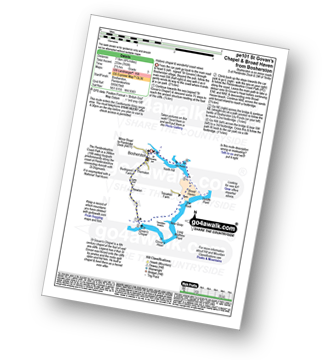
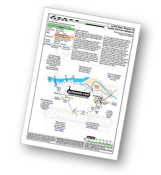
Route Summary:
Bosherston - Castlemartin Firing Range - The Pembrokeshire Coastal Path - St Govan's Chapel - St Govan's Head - Long Matthew Point - Trevallen Downs - New Quay - Broad Haven - Bosheston Lily Ponds - Bosheston.
|
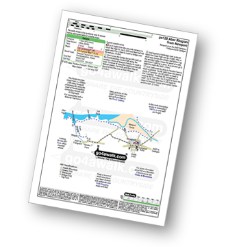
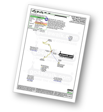
Vital Statistics:
| Length: | 4 miles (6 km) |
| Ascent: | 830ft (253m) |
| Time: | 2.25hrs |
| Grade: | |
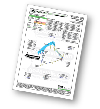
Route Summary:
Moylgrove - Cwm Trewyddel - Ceibwr Bay - The Pembrokeshire Coast Path - Careg Wylan - Traeth Bach - Careg Yspar - Cwm Flynnon-alwm - Treriffith Farm - Moylgrove
|
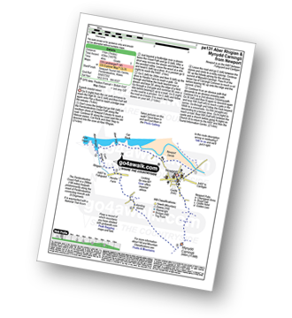
Vital Statistics:
| Length: | 3.5 miles (5.5 km) |
| Ascent: | 460ft (140m) |
| Time: | 1.75hrs |
| Grade: | |
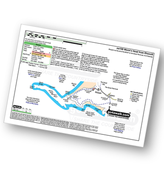
Route Summary:
Rhossili - The Gower Way - Middleton - Mewslade Bay - Fall Bay - The Gower Coast National Nature Reserve - Tears Point - Worms Head - Kitchen Corner - Rhossili Bay - Rhossili
|
Vital Statistics:
| Length: | 8 miles (12.5 km) |
| Ascent: | 1,182ft (360m) |
| Time: | 4 hrs |
| Grade: | |
Route Summary:
Oxwich Bay - Oxwich - Oxwich Marsh - Penrice - Mill Wood - Penrice Castle - Perriswood - The Gower Way - Cefn Bryn - Penmaen - Three Cliffs Bay - Penmaen Burrows - Nicholaston Burrows - Oxwich Bay - Oxwich Burrows - Oxwich.
|
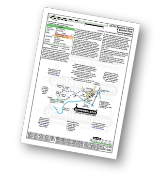
Vital Statistics:
| Length: | 5.5 miles (8.5 km) |
| Ascent: | 945ft (288m) |
| Time: | 3 hrs |
| Grade: | |
Route Summary:
Parkmill - Pennard Castle - The Gower - Three Cliffs Bay - Penmaen - The Gower Way - Cefn Bryn - Park Woods - Green Cwm - Cathole Rock - Parkmill
|
Vital Statistics:
| Length: | 3.75 miles (6 km) |
| Ascent: | 499ft (152m) |
| Time: | 2 hrs |
| Grade: | |
Route Summary:
Llandeilo - Llandeilo Bridge - River Towy - Afon Tywi - Pen Lan-fawr - Castle Wood - Dinefwr Castle/Dynevor Castle - Bog Wood - Newton House - Dinefwr Park - Llandeilo
|
Vital Statistics:
| Length: | 1.5 miles (2.5 km) |
| Ascent: | 440ft (134m) |
| Time: | 1 hrs |
| Grade: |  |
|
Vital Statistics:
| Length: | 8.5 miles (13.5 km) |
| Ascent: | 2,914ft (888m) |
| Time: | 6 hrs |
| Grade: | |
Route Summary:
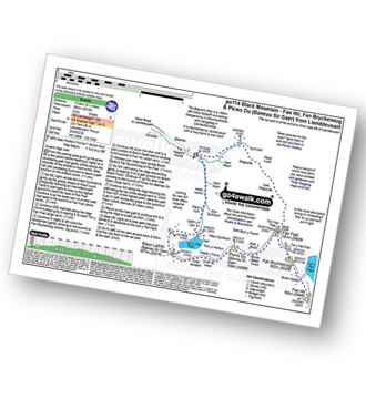
Car Park SE of Llanddeusant - Nant Melyn - Sychnant - Disgwylfa - Cefn Disgwylfa - Tro'r Fan Foel - Fan Foel - The Beacons Way - Twr y Fan Foel - Fan Brycheiniog - Fan Hir - Fan Brycheiniog (Twr y Fan Foel) - Fan Foel - Bwlch Blaen Twrch - Pant y Bwlch - Picws Du (Bannau Sir Gaer) - Glastir y Picws - Cwar Du Mawr - Cwar Du Bach - Waun Lefrith (Bannau Sir Gaer) - Llyn y Fan Fach - Llethr y Llyn - Waun y Llyn - Nant Coch - Car Park SE of Llanddeusant
|
Vital Statistics:
| Length: | 6.25 miles (10 km) |
| Ascent: | 2,130ft (649m) |
| Time: | 4½ hrs |
| Grade: | |
Route Summary:
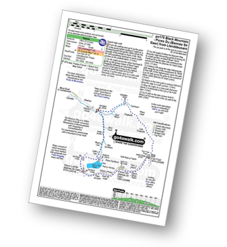
Car Park SE of Llanddeusant - Nant Melyn - Sychnant - Disgwylfa - Cefn Disgwylfa - Tro'r Fan Foel - Fan Foel - The Beacons Way - Twr y Fan Foel - Bwlch Blaen Twrch - Pant y Bwlch - Picws Du (Bannau Sir Gaer) - Glastir y Picws - Cwar Du Mawr - Cwar Du Bach - Waun Lefrith (Bannau Sir Gaer) - Llyn y Fan Fach - Llethr y Llyn - Waun y Llyn - Nant Coch - Car Park SE of Llanddeusant
Not familiar with the area around SA62?
See these 30 nearest walks to UK Postcode SA62 on a google map


