Two easy to follow pub walks from The Moorfield Arms, Rowarth, The Peak District, Derbyshire, England
To reach The Moorfield Arms, Rowarth, in-car SatNav users should select the Latitude/Longitude (Lat Lon) screen and enter:
Lat = N53.40067 and Lon = W 1.99963
Tap/mouse over a coloured circle (1-3 easy walks, 4-6 moderate walks, 7-9 hard walks) and click to select.
Tap/mouse over a coloured circle (1-3 easy walks, 4-6 moderate walks, 7-9 hard walks) and click to select.
Two easy to follow pub walks from The Moorfield Arms, Rowarth, The Peak District, Derbyshire, England
Scroll down the list of walks below & click on each walk title (in blue) to locate it on the map above.
   |
Vital Statistics:
| Length: | 9.5 miles (15 km) |
| Ascent: | 1,696ft (517m) |
| Time: | 5.25hrs |
| Grade: |  |
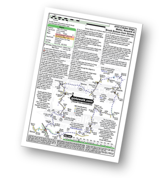
Route Summary:
Strines Station - Lower Cliffe Cottage - Higher Banks Cottage - Cobden Edge - Mellor Moor - Mellor - Mellor Church - Hilltop Farm - Shiloh Hall Farm - Ringstones Farm - Ayton Farm - Rowarth - Thornsett Fields Farm - New Mills - Whitle - Brook Bottom - The Goyt Way - The Midshires Way - Strines Station
|
Vital Statistics:
| Length: | 10.5 miles (17 km) |
| Ascent: | 2,055ft (626m) |
| Time: | 6 hrs |
| Grade: | |
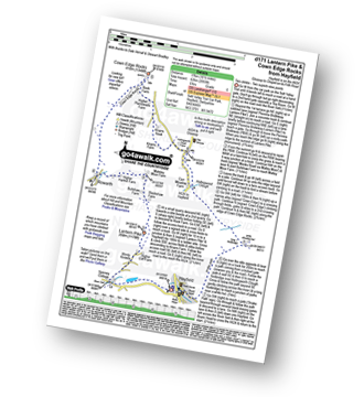
Route Summary:
Hayfield - Sett Valley Trail - Birch Vale - The River Sett - The Pennine Bridleway - Lantern Pike - Rowarth - Cown Edge Rocks - Chunal Road (Glossop) - Hollingwood Clough - Middle Moor (Hayfield) - The Snake Path - Hayfield


