Nineteen easy to follow walks from Holme Farm Campsite, Horton In Ribblesdale, The Yorkshire Dales, North Yorkshire, England
To reach Holme Farm Campsite, Horton In Ribblesdale, in-car SatNav users should select the Latitude/Longitude (Lat Lon) screen and enter:
Lat = N54.14607 and Lon = W2.2936 or postcode: BD24 0HD
Tap/mouse over a coloured circle (1-3 easy walks, 4-6 moderate walks, 7-9 hard walks) and click to select.
Tap/mouse over a coloured circle (1-3 easy walks, 4-6 moderate walks, 7-9 hard walks) and click to select.
Nineteen easy to follow walks from Holme Farm Campsite, Horton In Ribblesdale, The Yorkshire Dales, North Yorkshire, England
Scroll down the list of walks below & click on each walk title (in blue) to locate it on the map above.
   |
Vital Statistics:
| Length: | 4.75 miles (7.5 km) |
| Ascent: | 984ft (300m) |
| Time: | 3 hrs |
| Grade: |  |
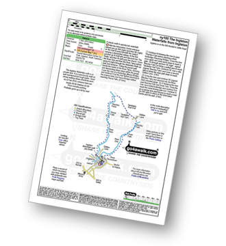
Route Summary:
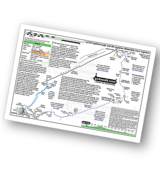
Ingleton - The Ingleton Waterfalls Trail - River Twiss - Swilla Glen - The Money Tree - Helks - Mount - Manor Bridge - Constitution Hill - Pecca Bridge - Pecca Falls - Thornton Force - Raven Ray Bridge - Kingsdale - Twistleton Hall - River Doe - Beezley Falls - Rival Falls - Snow Falls - Ingleton
|
Vital Statistics:
| Length: | 5 miles (8 km) |
| Ascent: | 961ft (293m) |
| Time: | 3 hrs |
| Grade: | |
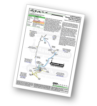
Route Summary:
Ingleton - Thornton Hall Farm - Kingsdale - River Dow - The Ingleton Waterfalls Trail Beezley Falls - Rival Falls - Snow Falls - Ingleton
| |
Vital Statistics:
| Length: | 4.5 miles (7 km) |
| Ascent: | 977ft (298m) |
| Time: | 2.75hrs |
| Grade: | |
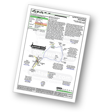
Route Summary:
Settle - Constitution Hill - Attermire - Attermire Scar - Warrendale Knotts - Victoria Cave - Clay Pits Plantation - Blua Crags - Settle
|
Vital Statistics:
| Length: | 6 miles (9.5 km) |
| Ascent: | 1,175ft (358m) |
| Time: | 3½ hrs |
| Grade: |  |
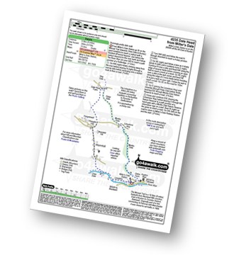
Route Summary:
Miller's Dale Station - The Monsal Trail - River Wye - Wormhill - Dale Head - Peter Dale - Monk's Dale - Miller's Dale - Miller's Dale Station
|
Vital Statistics:
| Length: | 6.25 miles (10 km) |
| Ascent: | 1,640ft (489m) |
| Time: | 4 hrs |
| Grade: |  |
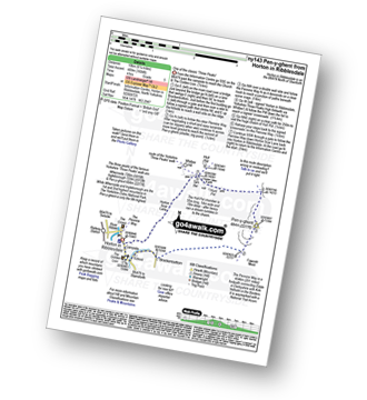
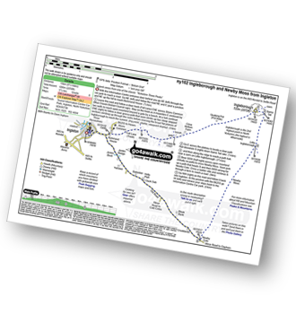
Route Summary:
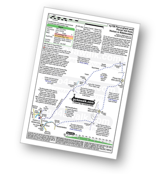
Horton in Ribblesdale - Brackenbottom - Gavel Rigg - The Pennine Way - Pen-y-ghent - Hunt Pot - Hull Pot - Horton in Ribblesdale.
|
Vital Statistics:
| Length: | 8.25 miles (13 km) |
| Ascent: | 1,279ft (390m) |
| Time: | 4.25hrs |
| Grade: | |
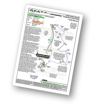
Route Summary:
Settle - Constitution Hill - Attermire - Attermire Scar - Victoria Cave - Clay Pits Plantation - Upper Winskill - Catrigg Force (waterfall) - Stainforth - Langcliffe - Settle
|
Vital Statistics:
| Length: | 9 miles (14.5 km) |
| Ascent: | 1,644ft (501m) |
| Time: | 5 hrs |
| Grade: | |
Route Summary:
Ribblehead - (Railway Station - After Train Journey From Horton in Ribblesdale) - B6255 - Old Hill Inn - Chapel-le-Dale - Braithwaite Wife Hole - Ingleborough - Pen-y-ghent Cafe - Horton in Ribblesdale.
|
Vital Statistics:
| Length: | 12.75 miles (20.5 km) |
| Ascent: | 1,959ft (597m) |
| Time: | 6.75hrs |
| Grade: |  |
Route Summary:
Peak Forest - Dam Dale - Hay Dale - Dale Head - Peter Dale - Monk's Dale - Miller's Dale - The Monsal Trail - Litton Mill - Tideswell Dale - Tideswell - Brook Bottom (Tideswell) - Batham Gate - Old Peak - Peak Forest
|
Vital Statistics:
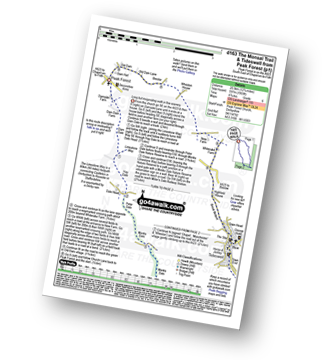
| Length: | 9.5 miles (15 km) |
| Ascent: | 2,250ft (686m) |
| Time: | 5½ hrs |
| Grade: | |
Route Summary:
Ingleton - Ingleton Information Centre - Richmond House - Fell Lane - Crina Bottom Farm - Quaking Pot - Ingleborough - Little Ingleborough - Newby Moss - Newby Cote - Bleak Bank - Duck Dub - Holly Platt - Slatenber - Jenkin Bridge - Ingleton
|
Vital Statistics:
| Length: | 10 miles (16 km) |
| Ascent: | 1,663ft (506m) |
| Time: | 5 hrs |
| Grade: | |
Route Summary:
Dale Head - The Pennine Way - Gavel Rigg - Pen-y-ghent - Plover Hill - Foxup Moor - Foxup Road - Low Bergh - Littondale - Pen-y-ghent Gill - Dale Head
|
Vital Statistics:
| Length: | 11.5 miles (18.5 km) |
| Ascent: | 1,961ft (598m) |
| Time: | 6.25hrs |
| Grade: | |
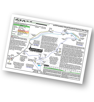
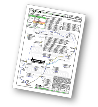
Route Summary:
Dale Head - The Pennine Way - Fountains Fell - Fountains Fell (South Top) - Fountains Fell Tarn - Darnbrook Fell - Wilson's Pasture - River Skirfare - Nether Hesleden Farm - Pen-y-ghent Gill - Dale Head
|
Vital Statistics:
| Length: | 10.5 miles (17 km) |
| Ascent: | 1,566ft (477m) |
| Time: | 5½ hrs |
| Grade: | |
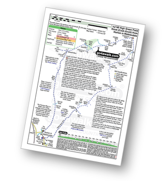
Route Summary:
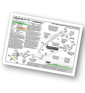
Horton In Ribblesdale - The Pennine Way - Sell Gill Holes - Sell Gill Beck - Red Moss Pot - Birkwith Moor - Birkwith Common - Green Haw Moor - Cosh Knott Well - Cosh Outside (Cosh Knott) - High Green Field Knott (Cosh Knott) - Cosh Beck Head - Lante Shop Caves - Cosh Water Gap - Black Banks - Turpen Horton Moor - Hull Pot Beck - Hull Pot - Hunt Pot - Horton Scar Lane - Horton In Ribblesdale
|
Vital Statistics:
| Length: | 10 miles (16 km) |
| Ascent: | 2,244ft (684m) |
| Time: | 5.75hrs |
| Grade: | |
Route Summary:
Ingleton - Fell Lane - Crina Bottom Farm - Quaking Pot - Ingleborough - Humphrey Bottom - Ingleborough Nature Reserve - Braithwaite Wife Hole - Souther Scales Farm - Chapel-le-Dale - Twistleton Scars - Oddies Lane - The Ingleton Waterfalls Trail - Beezley Falls - Snow Falls - Ingleton
|
Vital Statistics:
| Length: | 8.75 miles (14 km) |
| Ascent: | 1,827ft (557m) |
| Time: | 5 hrs |
| Grade: | |
Route Summary:
Horton In Ribblesdale - Brackenbottom - Gavel Rigg - The Pennine Way - Pen-y-ghent - Plover Hill - Foxup Moor - Swarth Gill Gate - Black Banks - Turpen - Horton Moor - Hull Pot - The Pennine Way - Horton Scar Lane - Horton In Ribblesdale
|
Vital Statistics:
| Length: | 9.5 miles (15 km) |
| Ascent: | 2,362ft (720m) |
| Time: | 5.75hrs |
| Grade: | |
Route Summary:
Ingleton - Ingleton Tourist Information Centre - Fell Lane - Crina Bottom Farm - Quaking Pot - Ingleborough - Humphrey Bottom - Ingleborough Nature Reserve - Raven Scar - High Howeth - Harry Hallam's Moss - White Scars - Ingleton
|
Vital Statistics:
| Length: | 16.5 miles (26 km) |
| Ascent: | 2,447ft (746m) |
| Time: | 8½ hrs |
| Grade: |  |
Route Summary:
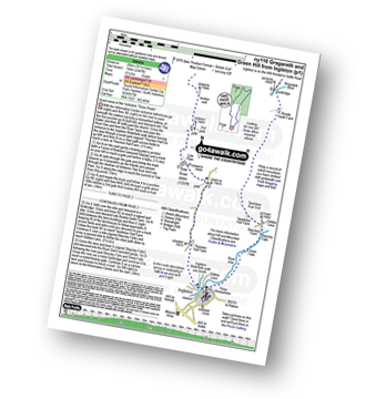
Ingleton - Thornton Hall Farm - Tow Scar - Gragareth - Green Hill (Gragareth) - Lancashire County Stone - High Pike - Kingsdale Beck - Braida Garth Farm - Twistleton Hall Farm - The Ingleton Waterfalls Trail - Beezley Falls - River Doe - Snow Falls - Ingleton
|
Vital Statistics:
| Length: | 14 miles (22.5 km) |
| Ascent: | 2,562ft (781m) |
| Time: | 7½ hrs |
| Grade: | |
Route Summary:
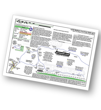
Settle - Constitution Hill - Attermire Scar - Victoria Cave - Stickdale Farm - Malham - Malham Cove - Limestone Pavement - Watlowes - Langscar Gate - Outside - Gorbeck - Jubilee Cave - Clay Pits Plantation - Settle
|
Vital Statistics:
| Length: | 14 miles (22.5 km) |
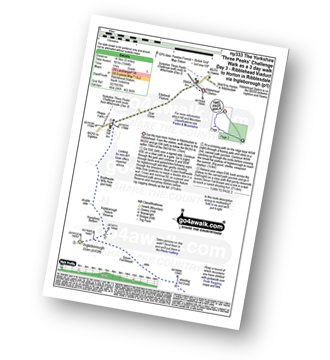
| Ascent: | 3,207ft (977m) |
| Time: | 8½ hrs |
| Grade: |  |
Route Summary:
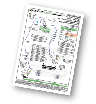
Horton in Ribblesdale - Railway Station - Train Journey - Ribblehead Railway Station - Ribblehead - Blea Moor - Whernside - Broadrake Farm - Ribblehead - Blea Moor - Whernside - Broadrake Farm - Chapel-le-Dale - Braithwaite Wife Hole - Ingleborough - Pen-y-ghent Cafe - Horton in Ribblesdale.
|
Vital Statistics:
| Length: | 24 miles (38.5 km) |
| Ascent: | 5,297ft (1,614m) |
| Time: | 14 hrs |
| Grade: |  |
Route Summary:
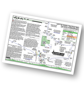
Horton in Ribblesdale - Pen-y-ghent Cafe - Brackenbottom - Gavel Rigg - The Pennine Way - Pen-y-ghent - Hunt Pot - Hull Pot - Whitber Hill - God's Bridge - Brow Gill Beck - Nether Lodge - River Ribble - Lodge Hall (or Ingman Lodge) - Ribblehead - Blea Moor - Whernside - Broadrake Farm - Chapel-le-Dale - Braithwaite Wife Hole - Ingleborough - Pen-y-ghent Cafe - Horton in Ribblesdale.


