
![]()
Hobcarton End
634m (2081ft)
The North Western Fells, The Lake District, Cumbria, England
Tap/mouse over a coloured circle (1-3 easy walks, 4-6 moderate walks, 7-9 hard walks) and click to select.
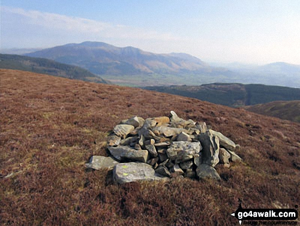
The summit of Hobcarton End is marked by a cairn.
After a survey by The Environment Agency Geomatics team in January 2021, Hobcarton End was demoted from being classified as a 'Nuttall' due to insufficient prominence.
Not familiar with this top?
   |
|---|
Vital Statistics:
| Length: | 6.5ml (10.5km) |
|---|---|
| Ascent: | 2,573ft (784m) |
| Time: | 5 hrs |
| Grade: |  (Moderate) (Moderate) |
Route Summary:
Revelin Moss - Whinlatter Forest Park - Hobcarton End - Grisedale Pike - Hobcarton Crag - Hopegill Head - Ladyside Pike - Swinside Plantation - Whinlatter Pass - Hobcarton Plantation - Revelin Moss
See Hobcarton End and the surrounding tops on our free-to-access 'Google Style' Peak Bagging Maps:
The North Western Fells of The Lake District National Park
Less data - quicker to download
The Whole of The Lake District National Park
More data - might take a little longer to download
See Hobcarton End and the surrounding tops on our downloadable Peak Bagging Maps in PDF format:

NB: Whether you print off a copy or download it to your phone, these PDF Peak Baggers' Maps might prove incredibly useful when your are up there on the tops and you cannot get a phone signal.
*This version is marked with the walk routes you need to follow to Walk all 214 Wainwrights in just 59 walks.
You can find Hobcarton End & all the walks that climb it on these unique free-to-access Interactive Walk Planning Maps:
1:25,000 scale OS Explorer Map (orange/yellow covers):
1:50,000 scale OS Landranger Maps (pink/magenta covers):
 Fellow go4awalkers who have already walked, climbed, summited & bagged Hobcarton End
Kevin Foster walked up Hobcarton End on March 4th, 2020 [from/via/route] Thornthwaite. [with] Henry. [weather] Cloudy with light snow showers. - What a nice approach to Hobcarton End & the start of my walk en route to Grisedale Pike (through Thornthwaite Forest via Whinlatter visitor centre).
Mark Davidson climbed Hobcarton End on March 11th, 2014 [with] Alone [weather] Gloriously sunny
Christine Shepherd bagged Hobcarton End on April 17th, 2015 [from/via/route] Walked from Revelin Moss car park using walk c169 [with] On my own [weather] Perfect walking weather. Clear, not too hot with a cool breeze. - I really enjoyed this route up Grisedale Pike. As much of the ascent was in the forest it was pleasantly cool & I was distracted by lots of beautiful birdsong.
Graham Coules hiked Hobcarton End on May 18th, 2014 [from/via/route] Grisedale Pike from Whinlatter [with] Dale [weather] Sunny
Ray O'hara summited Hobcarton End on February 28th, 2014 [from/via/route] Whinlatter Pass, Hobcarton End, Grisdale Pike, Hopegill Head, Whiteside, Hopegill Head, Ladyside Pike, Whinlatter Pass [weather] Clear blue skies, no wind & light powdery snow from about 1800' upwards. Utterly perfect, the sort of day you dream about.
Iain Taylor conquered Hobcarton End on December 26th, 2010 [from/via/route] Braithwaite (NY 23296 23665)
Patrick Rogozinski, Louise Sandwith and Leon Potts have all walked, climbed & bagged Hobcarton End.
To add (or remove) your name and experiences on this page - Log On and edit your Personal Mountain Bagging Record
More Photographs & Pictures of views from, on or of Hobcarton End
Send us your photographs and pictures on, of, or from Hobcarton End
If you would like to add your walk photographs and pictures featuring views from, on or of Hobcarton End to this page, please send them as email attachments (configured for any computer) along with your name to:
and we shall do our best to publish them.
(Guide Resolution = 300dpi. At least = 660pixels (wide) x 440 pixels (high).)

You can also submit photos via our Facebook Page.
NB. Please indicate where each photo was taken and whether you wish us to credit your photos with a Username or your First Name/Last Name.
Not familiar with this top?


