
![]()
Crag Fell
523m (1716ft)
The Western Fells, The Lake District, Cumbria, England
Tap/mouse over a coloured circle (1-3 easy walks, 4-6 moderate walks, 7-9 hard walks) and click to select.
Not familiar with this top?
   |
|---|
Vital Statistics:
| Length: | 7.75mls (12.5km) |
|---|---|
| Ascent: | 2,028ft (618m) |
| Time: | 5½ hrs |
| Grade: |  (Moderate) (Moderate) |
Route Summary:
Scaly Moss - Blackely Moss - Heckbarley Wood - Red Moss - Grike - Crag Fell - Black Pots - Whoap - Lank Rigg - Whoap Beck - Lankrigg Moss - Stinking Gill - Blackeley Raise - Whorl Gill - Scaly Moss
|
|---|
Vital Statistics:
| Length: | 11.75ml (19km) |
|---|---|
| Ascent: | 2,970ft (905m) |
| Time: | 7½ hrs |
| Grade: |  (Hard) (Hard) |
Route Summary:
Ennerdale Weir - Ennerdale Water - Silver Cove Beck - Woundell Beck - Caw Fell - Silver Cove - Iron Crag - Crag Fell - Grike - Ennerdale Weir
|
|---|
Vital Statistics:
| Length: | 15.25ml (24.5km) |
|---|---|
| Ascent: | 4,125ft (1,257m) |
| Time: | 9.75hrs |
| Grade: |  (Very Hard) (Very Hard) |
Route Summary:
Ennerdale Weir - Ennerdale Water - Silver Cove Beck - Woundell Beck - Little Gowder Crag - Haycock - Caw Fell - Silver Cove - Iron Crag - Whoap - Lank Rigg - Crag Fell - Grike - Ennerdale Weir
See Crag Fell and the surrounding tops on our free-to-access 'Google Style' Peak Bagging Maps:
The Western Fells of The Lake District National Park
Less data - quicker to download
The Whole of The Lake District National Park
More data - might take a little longer to download
See Crag Fell and the surrounding tops on our downloadable Peak Bagging Maps in PDF format:

NB: Whether you print off a copy or download it to your phone, these PDF Peak Baggers' Maps might prove incredibly useful when your are up there on the tops and you cannot get a phone signal.
*This version is marked with the walk routes you need to follow to Walk all 214 Wainwrights in just 59 walks.
You can find Crag Fell & all the walks that climb it on these unique free-to-access Interactive Walk Planning Maps:
1:25,000 scale OS Explorer Map (orange/yellow covers):
1:50,000 scale OS Landranger Map (pink/magenta covers):
 Fellow go4awalkers who have already walked, climbed, summited & bagged Crag Fell
Geoff Hand walked up Crag Fell on July 1st, 2025 [from/via/route] Walked from Scaly Moss to Grike, then onto Crag Fell, over Whoap & onto Lank Rigg. Back to the car by Whoap beck to Blakeley raise. [with] none [weather] Started off Sunny then cloud, mist & light rain caught me up at Crag Fell - When I got back to my car, the key fob wouldn't work. Eventually it worked & I had to high tail it to Workington to get a new barrey installed in the key.
Neil Heywood climbed Crag Fell on September 10th, 2014 [with] Logan Heywood Mike Hills
Ian Ashton bagged Crag Fell on August 11th, 2024 [with] Solo - Ì
Christine Shepherd hiked Crag Fell on August 13th, 2010 [from/via/route] Walked from Scaly Moss using walk c340 Climbed again on 31.8.20 using the same walk. Climbed for a third time on 28.4.24 did the same walk but added on Caw Fell [with] On my own [weather] A bit overcast . - There is a great view of Ennerdale from this summit.
Pete George summited Crag Fell on March 31st, 2024 [from/via/route] Scaly Moss, Enerdale [with] Roco [weather] Warm spring day
Charlotte Hewson conquered Crag Fell on May 7th, 2023 [from/via/route] Cold fell [with] Emma and Vicky [weather] CLOUD - Walk in the clouds
Simon Boddy scaled Crag Fell on May 2nd, 2023 [from/via/route] Bleach Green car park, Ennerdale [with] My girlfriend [weather] Fair
Richard Marchant walked up Crag Fell on November 4th, 2022 [from/via/route] Roadside parking just up from Blakeley Stone Circle. From here it was Eastward on a footpath/track up to the Grike from here it was a short ridge round to Crag Fell. From Crag Fell I headed South dropping down gradually before ascending up on to Whoap & finally ridging round to a short climb up on to Lank Rigg. I then back tracked down to the source of Whoap Beck & dropped down into the valley & basically followed the stream when it became the River Calder & veered off to join the road I parked on & followed it for a short distance back to my car. [with] On my Own [weather] Sun Shine & Showers sort of Day with a slight breeze & cold
Richard Fulcher climbed Crag Fell on July 31st, 2022 [from/via/route] Parked on the side of the road at Scaly Moss near Ennerdale Bridge. Set off along the old mine road turning off to climb Grike. From Grike to Crag Fell via a boggy path . Good view of Ennerdale from the edge of the fell. We then descended Crag Fell & then climbed up to Whoap then down to a col & up to Lank Rigg. After viewing Sellafield we descended back down to the col & then followed Whoap Beck around Blakeley & then down the road to the car. [with] Jen [weather] Warm, light breeze, cloudy & some blue sky.
Claire Murray bagged Crag Fell on July 9th, 2022 [from/via/route] Park at stone circle, clearly marked path up to Grike, Crag Fell, Whoap & Lank Rigg. Lots of beautiful Fell Ponies. [with] Vitor - Lots of Fell Ponies at the stone circle
To add (or remove) your name and experiences on this page - Log On and edit your Personal Mountain Bagging Record
. . . [see more walk reports]
More Photographs & Pictures of views from, on or of Crag Fell
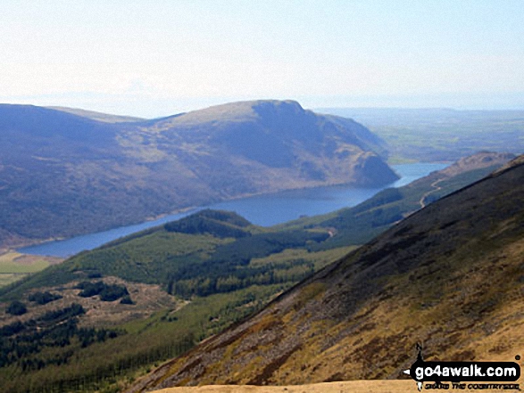
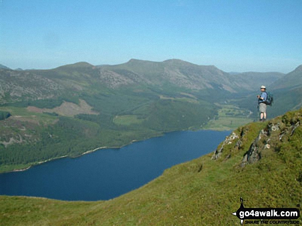
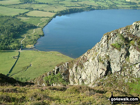
Iron Crag, Whoap, Crag Fell and Grike tower over Ennerdale Water from the summit of Red Pike (Buttermere)
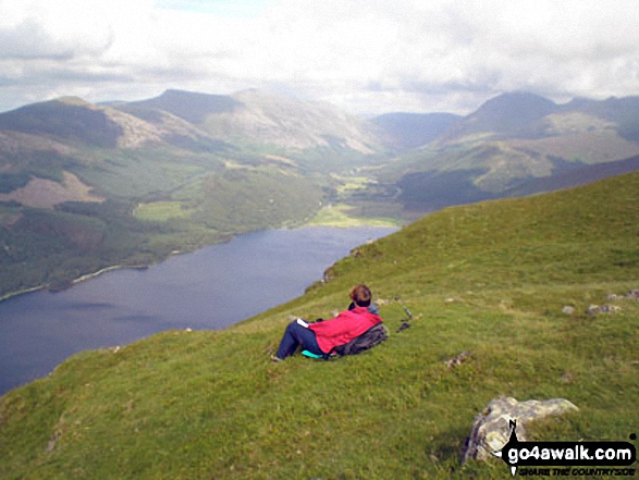
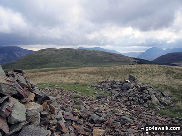
Starling Dodd (left), Red Pike (Buttermere), High Stile and Pillar (right) and Ennerdale Water from the summit of Crag Fell
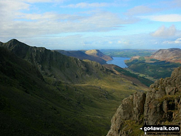
Steeple and Long Crag with Crag Fell (sunlit in the distance), Ennerdale Water and Great Borne from Pillar
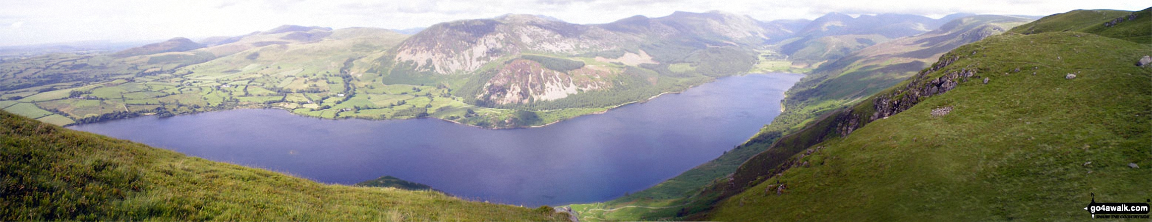
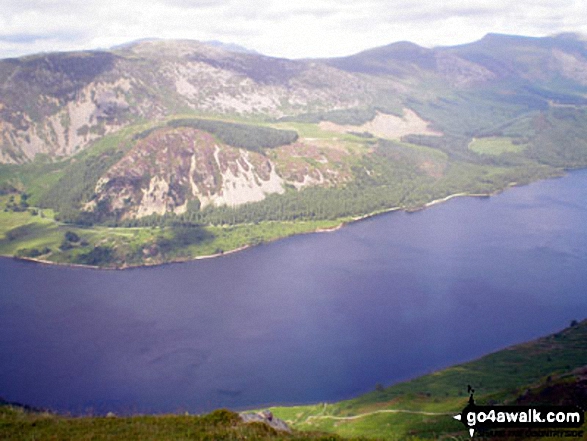
Ennerdale Bridge, Bowness Knott, Great Bourne, Starling Dodd, Red Pike (Buttermere), High Stile and Pillar sourrounding Ennerdale Water from the summit of Crag Fell
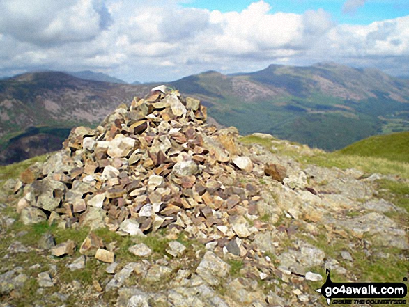
Crag Fell summit cairn with Great Borne (left), Starling Dodd (centre), Red Pike (Buttermere) and High Stile in the distance
Send us your photographs and pictures on, of, or from Crag Fell
If you would like to add your walk photographs and pictures featuring views from, on or of Crag Fell to this page, please send them as email attachments (configured for any computer) along with your name to:
and we shall do our best to publish them.
(Guide Resolution = 300dpi. At least = 660pixels (wide) x 440 pixels (high).)

You can also submit photos via our Facebook Page.
NB. Please indicate where each photo was taken and whether you wish us to credit your photos with a Username or your First Name/Last Name.
Not familiar with this top?


