
![]()
Caw Fell
697m (2288ft)
The Western Fells, The Lake District, Cumbria, England
Not familiar with this top?
   |
|---|
Vital Statistics:
| Length: | 11.25ml (18km) |
|---|---|
| Ascent: | 3,275ft (998m) |
| Time: | 7½ hrs |
| Grade: |  (Hard) (Hard) |
Route Summary:
Bowness Knott Car Park Ennerdale Water - Char Dub - Silver Cove Beck - Woundell Beck - Caw Fell - Little Gowder Crag - Haycock - Great Scoat Fell - Scoat Fell (Little Scoat Fell) - Steeple - Long Crag - Moss Dub - Lingmell Plantation - Bowness Knott Car Park Ennerdale Water.
|
|---|
Vital Statistics:
| Length: | 11.75ml (19km) |
|---|---|
| Ascent: | 2,970ft (905m) |
| Time: | 7½ hrs |
| Grade: | (Hard) |
Route Summary:
Ennerdale Weir - Ennerdale Water - Silver Cove Beck - Woundell Beck - Caw Fell - Silver Cove - Iron Crag - Crag Fell - Grike - Ennerdale Weir
|
|---|
Vital Statistics:
| Length: | 15.25ml (24.5km) |
|---|---|
| Ascent: | 4,125ft (1,257m) |
| Time: | 9.75hrs |
| Grade: |  (Very Hard) (Very Hard) |
Route Summary:
Ennerdale Weir - Ennerdale Water - Silver Cove Beck - Woundell Beck - Little Gowder Crag - Haycock - Caw Fell - Silver Cove - Iron Crag - Whoap - Lank Rigg - Crag Fell - Grike - Ennerdale Weir
See Caw Fell and the surrounding tops on our free-to-access 'Google Style' Peak Bagging Maps:
The Western Fells of The Lake District National Park
Less data - quicker to download
The Whole of The Lake District National Park
More data - might take a little longer to download
See Caw Fell and the surrounding tops on our downloadable Peak Bagging Maps in PDF format:

NB: Whether you print off a copy or download it to your phone, these PDF Peak Baggers' Maps might prove incredibly useful when your are up there on the tops and you cannot get a phone signal.
*This version is marked with the walk routes you need to follow to Walk all 214 Wainwrights in just 59 walks.
You can find Caw Fell & all the walks that climb it on these unique free-to-access Interactive Walk Planning Maps:
1:25,000 scale OS Explorer Map (orange/yellow covers):
1:50,000 scale OS Landranger Map (pink/magenta covers):
 Fellow go4awalkers who have already walked, climbed, summited & bagged Caw Fell
Geoff Hand walked up Caw Fell on September 23rd, 2025 [from/via/route] Walk c130 from Ennerdale Water upto Caw, then double back to Gowder & Haycock. return by Scout Fell & Steeple & long crag.and Lingmell. [with] Richard Macilwaine [weather] Another bright clear sunny day, bit of a cool breeze on the tops. Sunny & warm in the valley. - Had to do a bit of wading across Woundell Beck on the way back as the footbridge was being replaced.
Ian Ashton climbed Caw Fell on January 25th, 2025 [with] Ella
Tim Winn bagged Caw Fell on October 26th, 2024 [from/via/route] Ennerdale [with] Barry, Paul and Roger [weather] Dry.
Christine Shepherd hiked Caw Fell on February 17th, 2008 [from/via/route] Walked from Bowness Knott Car park, Ennerdale using walk c130 Bagged again 16.04.14 using the start of walk 267 Climbed again with Louise on 28.4.24 adding this fell to The c340 walk to Grike, Crag fell & Lank Rigg. [with] On my own [weather] Beautiful, bright winter sunshine. - A wonderful start to a glorious day's walking.
John Tippins summited Caw Fell on May 5th, 2023 [from/via/route] From Bowness Knott car park [with] Alone [weather] Warm & sunny to start with. Just before reaching the top it started raining. Heavy rain, moderately strong winds & thick cloud for the next couple of hours. Stopped raining, still misty until halfway down to the valley floor, then warm & sunny again.
Sarah Moore conquered Caw Fell on April 8th, 2023 [from/via/route] c130 / Caw Fell, Haycock & Steeple... with extra! from Ennerdale YHA [with] On my own [weather] Great day for it - almost too hot at points - clear for miles & sunny & beautiful - Couldn't believe how quiet it was for an Easter weekend - remote but incredible
Richard Marchant scaled Caw Fell on September 24th, 2022 [from/via/route] Parked at the forest car park below Bowness Knot & walk up the side of Ennerdale Water heading East & at the end I headed South on a Forestry track then a footpath through the woods & up a ridge that finally brought me out to the col between Caw Fell & Haycock. I nipped up to Caw Fell & back along the ridge to Little Colder Crag & on to Haycock. Then across to Scoat Fell & descended down off there on to Steeple & carried on along Long Crag & eventually back to the bottom of Ennerdale & followed the Forest track back to my car. [with] On my Own [weather] Clear Sunny day with little or no breeze.
Kevin Foster walked up Caw Fell on June 15th, 2022 [from/via/route] Little Gowder Crag. [with] By myself. [weather] Dry & sunny. - After rejoining the main path it's just a pleasant saunter over grass with little in the way of gradient to the next top Caw Fell. Important to cross the wall via the stile as the summit cairn is to the north of the wall. As you would expect from a flattish top with a big wall traversing it the views are not that impressive especially South.
Paul Macey climbed Caw Fell on August 19th, 2021 [from/via/route] C130 in reverse [weather] High cloud to start kow about 400 cloud base at end
Chris Sheard bagged Caw Fell on June 27th, 2021 [from/via/route] Up from Cold fell Road [with] George [weather] Warm, slight winds a bit sweaty in calm valleys - Nice mountain top, with impressive views all around
To add (or remove) your name and experiences on this page - Log On and edit your Personal Mountain Bagging Record
. . . [see more walk reports]
More Photographs & Pictures of views from, on or of Caw Fell
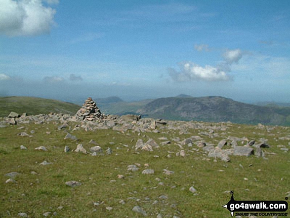
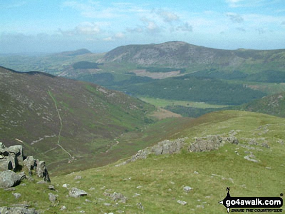
*From Left to right: Caw Fell, Seatallan, Red Pike, Pillar, Yewbarrow, Kirk Fell, Great Gable, Lingmell and Sca Fell and Wast Water (foreground) from Illgill Head (NB. Scafell Pike is largely hidden behind Sca Fell)
Send us your photographs and pictures on, of, or from Caw Fell
If you would like to add your walk photographs and pictures featuring views from, on or of Caw Fell to this page, please send them as email attachments (configured for any computer) along with your name to:
and we shall do our best to publish them.
(Guide Resolution = 300dpi. At least = 660pixels (wide) x 440 pixels (high).)

You can also submit photos via our Facebook Page.
NB. Please indicate where each photo was taken and whether you wish us to credit your photos with a Username or your First Name/Last Name.
Not familiar with this top?


