
![]()
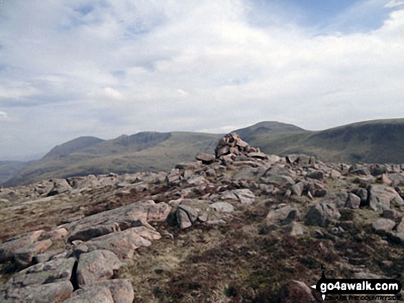
Iron Crag
640m (2100ft)
The Western Fells, The Lake District, Cumbria, England
Not familiar with this top?
   |
|---|
Vital Statistics:
| Length: | 11.75ml (19km) |
|---|---|
| Ascent: | 2,970ft (905m) |
| Time: | 7½ hrs |
| Grade: |  (Hard) (Hard) |
Route Summary:
Ennerdale Weir - Ennerdale Water - Silver Cove Beck - Woundell Beck - Caw Fell - Silver Cove - Iron Crag - Crag Fell - Grike - Ennerdale Weir
|
|---|
Vital Statistics:
| Length: | 15.25ml (24.5km) |
|---|---|
| Ascent: | 4,125ft (1,257m) |
| Time: | 9.75hrs |
| Grade: |  (Very Hard) (Very Hard) |
Route Summary:
Ennerdale Weir - Ennerdale Water - Silver Cove Beck - Woundell Beck - Little Gowder Crag - Haycock - Caw Fell - Silver Cove - Iron Crag - Whoap - Lank Rigg - Crag Fell - Grike - Ennerdale Weir
See Iron Crag and the surrounding tops on our free-to-access 'Google Style' Peak Bagging Maps:
The Western Fells of The Lake District National Park
Less data - quicker to download
The Whole of The Lake District National Park
More data - might take a little longer to download
See Iron Crag and the surrounding tops on our downloadable Peak Bagging Maps in PDF format:

NB: Whether you print off a copy or download it to your phone, these PDF Peak Baggers' Maps might prove incredibly useful when your are up there on the tops and you cannot get a phone signal.
*This version is marked with the walk routes you need to follow to Walk all 214 Wainwrights in just 59 walks.
You can find Iron Crag & all the walks that climb it on these unique free-to-access Interactive Walk Planning Maps:
1:25,000 scale OS Explorer Map (orange/yellow covers):
1:50,000 scale OS Landranger Map (pink/magenta covers):
 Fellow go4awalkers who have already walked, climbed, summited & bagged Iron Crag
Paul Macey walked up Iron Crag on June 5th, 2022 [from/via/route] C130 [with] Luke
Kevin Foster climbed Iron Crag on June 15th, 2022 [from/via/route] Caw Fell. [with] By myself. [weather] Dry & sunny. - The main thing I remember about this top was that it was a long 'out & back' from Caw Fell & the cairn was East of a very large & substantial wall with no obvious stile or gate nearby. Unless you like clambering 7ft drystone walls…you have been warned! NB. Walks: c199 Iron Crag & Grike from Ennerdale Water & c267 Haycock, Iron Crag, Lank Rigg & Grike from Ennerdale Water both have full details how to access the summit without climbing over any walls. Ed.
Caroline Winter bagged Iron Crag on September 1st, 2020 [from/via/route] Ennerdale water Bleach car park, Anglers Crag, Crag Fell, Iron Crag, return to Crag fell, Ben Gill [with] Becky [weather] Very good views. Warm day 12 degrees on tops - Easier ascent is Ben Gill. Long walk along wall line to Iron crag. Had to retract to gate in wall to cross to west side. Found ourselves on forest track below Crag Fell on return but found metal pipe to descend Ben Gill. Plantation being felled due to disease (also, trees removed below Crag Fell), & advise not to take diagonal track, but no alternative offered. We needed to take route through derelict mill to get back to CP
Chris Faulkner hiked Iron Crag on April 15th, 2018 [from/via/route] From Ennerdale. [with] Michelle Chandler [weather] Clear, blowy day.
Mark Davidson summited Iron Crag on June 11th, 2006 [with] Theresa [weather] Quite nice in the valleys but misty on the tops
Christine Shepherd conquered Iron Crag on April 16th, 2014 [from/via/route] Walked from Bowness Knott Car Park Ennerdale using part of walk c267 [with] On my own [weather] A clear Spring day with quite a breeze on the tops. - Came down to the lake beside a wall after bagging Iron Crag. Very steep & slow going but good to walk on the side of Ennerdale that I had had to give a miss on the Coast to Coast due to bad weather. Good to have bagged my last Hewitt in the Lakes.
Darren Mortimer scaled Iron Crag on October 5th, 2013 [from/via/route] c264 From Ennerdale water [with] Dermot Palmer [weather] Fine with misty tops
Iain Taylor walked up Iron Crag on July 31st, 2013 [from/via/route] Walked from Greendale near Wast Water NZ 14443 05610
Ray O'hara climbed Iron Crag on June 4th, 2012 [from/via/route] Wasdale Head - Looking Stead - Pillar - Black Crag - Scoat Fell - Steeple - Scoat Fell - Haycock - Caw Fell - Iron Crag - Caw Fell - Haycock - Scoat Fell - Red Pike (Wasdale) - Yewbarrow - Wasdale Head [weather] Glorious sunshine all the way. Best weather in an otherwise inclement week. - Love teh scramble up Dore Head onto Yewbarrow.... less keen on descending the scree slope at the Wastwater end.
Patrick Rogozinski, Paul Booth and Trevor Williams have all walked, climbed & bagged Iron Crag.
To add (or remove) your name and experiences on this page - Log On and edit your Personal Mountain Bagging Record
More Photographs & Pictures of views from, on or of Iron Crag
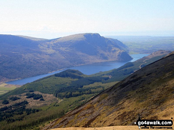
Iron Crag, Whoap, Crag Fell and Grike tower over Ennerdale Water from the summit of Red Pike (Buttermere)
Send us your photographs and pictures on, of, or from Iron Crag
If you would like to add your walk photographs and pictures featuring views from, on or of Iron Crag to this page, please send them as email attachments (configured for any computer) along with your name to:
and we shall do our best to publish them.
(Guide Resolution = 300dpi. At least = 660pixels (wide) x 440 pixels (high).)

You can also submit photos via our Facebook Page.
NB. Please indicate where each photo was taken and whether you wish us to credit your photos with a Username or your First Name/Last Name.
Not familiar with this top?


