
![]()
Stac Rhos
630m (2067ft)
The Berwyns, Snowdonia, Powys, Wales
Not familiar with this top?
   |
|---|
Vital Statistics:
| Length: | 10.5ml (17km) |
|---|---|
| Ascent: | 2,081ft (634m) |
| Time: | 6 hrs |
| Grade: |  (Moderate) (Moderate) |
Route Summary:
Hirnant Pass - Pen y Cerrig - Pen y Boncyn Trefeilw - Stac Rhos - Cefn Gwyntog - Foel Cedig - Cyrniau Nod - Y Groes Fagl - Pennllyn Forest - Ystrad-y-groes - Hirnant Pass
|
|---|
Vital Statistics:
| Length: | 12.75ml (20.5km) |
|---|---|
| Ascent: | 2,763ft (842m) |
| Time: | 7½ hrs |
| Grade: |  (Hard) (Hard) |
Route Summary:
Hirnant Pass - Foel Goch (Berwyns) - Trum y Gwrgedd - Trum y Gwragedd - Foel y Geifr (Berwyns) - Pen y Cerrig Duon - Pen y Boncyn Trefeilw - Stac Rhos - Cefn Gwyntog - Foel Cedig - Cyrniau Nod - Y Groes Fagl - Pennllyn Forest - Ystrad-y-groes - Hirnant Pass
See Stac Rhos and the surrounding tops on our free-to-access 'Google Style' Peak Bagging Maps:
The Berwyns of Snowdonia National Park
Less data - quicker to download
The Whole of Snowdonia National Park
More data - might take a little longer to download
See Stac Rhos and the surrounding tops on our downloadable Peak Bagging Map in PDF format:

NB: Whether you print off a copy or download it to your phone, this PDF Peak Baggers' Map might prove incredibly useful when your are up there on the tops and you cannot get a phone signal.
You can find Stac Rhos & all the walks that climb it on these unique free-to-access Interactive Walk Planning Maps:
1:25,000 scale OS Explorer Maps (orange/yellow covers):
An Interactive Walk Planning Map for OS Explorer 239 Lake Vyrnwy & Llanfyllin is not currently available
1:50,000 scale OS Landranger Map (pink/magenta covers):
 Fellow go4awalkers who have already walked, climbed, summited & bagged Stac Rhos
Christina Lander walked up Stac Rhos on July 30th, 2024 [from/via/route] Parking area next to the bridge by Foel y Ddinas on the Hirnant Pass - up the grassy ridge to Pen Cerrig Duon - Pen y Boncyn Trefeilw - Stac Rhos - Cefn Gwntog - Foel Cedig - Cyrniau Nod - Y Groes Fagl - through Penllyn Forest back to start [with] Dick [weather] A beautiful, hot sunny day - During our holiday staying at Y Gilfach, Bryn Melyn, Llandderfel
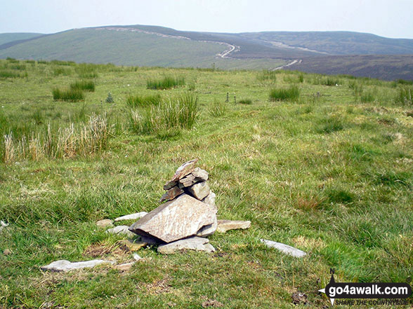
Stephanie Doyle climbed Stac Rhos on April 15th, 2023 [with] Friend [weather] Beautiful - No cairn
Mark Davidson bagged Stac Rhos on July 3rd, 2006 [from/via/route] Walk gw120 The Western Berwyns from Hirnant Pass [with] Alone [weather] Nice & sunny
Robert Taylor-Marriott hiked Stac Rhos on October 22nd, 2012 [from/via/route] Route 42: Pen y Boncyn Trefeilw & Stac Rhos (PBTSR). [with] Vence Wetton and Robert Taylor-Marriott. [weather] Cloudy.
Vince Wetton summited Stac Rhos on October 22nd, 2012 [with] RTM [weather] Cloud + Rain
Paul Booth and Richard Penney have both walked, climbed & bagged Stac Rhos.
To add (or remove) your name and experiences on this page - Log On and edit your Personal Mountain Bagging Record
More Photographs & Pictures of views from, on or of Stac Rhos
Send us your photographs and pictures on, of, or from Stac Rhos
If you would like to add your walk photographs and pictures featuring views from, on or of Stac Rhos to this page, please send them as email attachments (configured for any computer) along with your name to:
and we shall do our best to publish them.
(Guide Resolution = 300dpi. At least = 660pixels (wide) x 440 pixels (high).)

You can also submit photos via our Facebook Page.
NB. Please indicate where each photo was taken and whether you wish us to credit your photos with a Username or your First Name/Last Name.
Not familiar with this top?


