
![]()
Cyrniau Nod
666m (2185ft)
The Berwyns, Powys, Wales
*Cyrniau Nod is actually just outside of The National Park Boundary
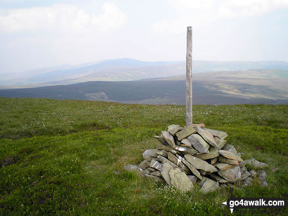
Cyrniau Nod lost its status as a Welsh Mountain (Hewitt), a 'Nuttall' and a 'Marilyn' in August, 2018 to Foel Cedig 800m to the NW which is slightly higher. Cyrniau Nod is now a 'Bridget'.
Not familiar with this top?
   |
|---|
Vital Statistics:
| Length: | 10.5ml (17km) |
|---|---|
| Ascent: | 2,081ft (634m) |
| Time: | 6 hrs |
| Grade: |  (Moderate) (Moderate) |
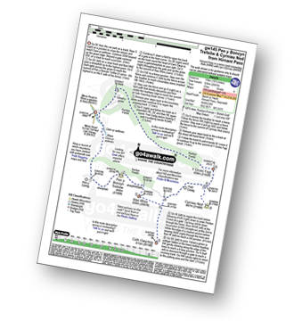
Route Summary:
Hirnant Pass - Pen y Cerrig - Pen y Boncyn Trefeilw - Stac Rhos - Cefn Gwyntog - Foel Cedig - Cyrniau Nod - Y Groes Fagl - Pennllyn Forest - Ystrad-y-groes - Hirnant Pass
|
|---|
Vital Statistics:
| Length: | 12.75ml (20.5km) |
|---|---|
| Ascent: | 2,763ft (842m) |
| Time: | 7½ hrs |
| Grade: |  (Hard) (Hard) |
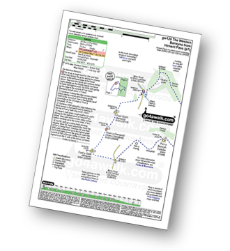
Route Summary:
Hirnant Pass - Foel Goch (Berwyns) - Trum y Gwrgedd - Trum y Gwragedd - Foel y Geifr (Berwyns) - Pen y Cerrig Duon - Pen y Boncyn Trefeilw - Stac Rhos - Cefn Gwyntog - Foel Cedig - Cyrniau Nod - Y Groes Fagl - Pennllyn Forest - Ystrad-y-groes - Hirnant Pass
See Cyrniau Nod and the surrounding tops on our free-to-access 'Google Style' Peak Bagging Map:
The Berwyns of Snowdonia National Park
Less data - quicker to download
See Cyrniau Nod and the surrounding tops on our downloadable Peak Bagging Map in PDF format:

NB: Whether you print off a copy or download it to your phone, this PDF Peak Baggers' Map might prove incredibly useful when your are up there on the tops and you cannot get a phone signal.
You can find Cyrniau Nod & all the walks that climb it on these unique free-to-access Interactive Walk Planning Maps:
1:25,000 scale OS Explorer Maps (orange/yellow covers):
An Interactive Walk Planning Map for OS Explorer 239 Lake Vyrnwy & Llanfyllin is not currently available
1:50,000 scale OS Landranger Map (pink/magenta covers):
 Fellow go4awalkers who have already walked, climbed, summited & bagged Cyrniau Nod
Stephanie Doyle walked up Cyrniau Nod on September 1st, 2023 [from/via/route] From campsite [weather] Beautiful - Great views
Donovan Suddell climbed Cyrniau Nod on April 1st, 2021 [from/via/route] GW120 [weather] Misty
David Lane bagged Cyrniau Nod on December 2nd, 2006 [with] Kelly
Vince Wetton hiked Cyrniau Nod on October 12th, 2012 [with] RTM [weather] Rain
Trevor Williams, Paul Booth and Richard Penney have all walked, climbed & bagged Cyrniau Nod.
To add (or remove) your name and experiences on this page - Log On and edit your Personal Mountain Bagging Record
Send us your photographs and pictures on, of, or from Cyrniau Nod
If you would like to add your walk photographs and pictures featuring views from, on or of Cyrniau Nod to this page, please send them as email attachments (configured for any computer) along with your name to:
and we shall do our best to publish them.
(Guide Resolution = 300dpi. At least = 660pixels (wide) x 440 pixels (high).)

You can also submit photos via our Facebook Page.
NB. Please indicate where each photo was taken and whether you wish us to credit your photos with a Username or your First Name/Last Name.
Not familiar with this top?


