All The Mountains, Peaks, Tops and Hills in Scottish Region 16: Assynt and The Far North as a detailed list
Scottish Region 16: Assynt and The Far North region is the area enclosed by an imaginary line connecting:
- Cape Wrath to John o' Groats via Durness, Loch Eriboll, Kyle of Tongue, Portskerra, Thurso and Dunnet to the North
- John o' Groats to Dornoch via Wick, Dunbeath and Helmsdale to the South East
- Dornoch to Rhue Lighthouse via Dornich Firth, the A949, Inveran, the A837, Linsidemore, Doune, Langwell, Oykel Bridge, Loubcroy, Ledmore, the A835, Elphin and Strathcanaird to the South
- Rhue Lighthouse to Cape Wrath to the North West
If you include all the Munros, the Corbetts, the Grahams, the Donalds, the Murdos, the Marilyns, the Bridgets (Hills) and all the Mountains, Tops, Peaks and Hills with a Trig Point on them there are 92 tops to climb, bag & conquer and the highest point is Ben More Assynt at 998m (3,275ft).
To see all Mountains, Peaks, Tops and Hills displayed in different ways - see the options in the left-hand column and towards the bottom of this page.
![]() Your Personal Bagging Record for Scottish Region 16: Assynt and The Far North
Your Personal Bagging Record for Scottish Region 16: Assynt and The Far North
When logged on, you can mark each Mountain, Peak, Top or Hill as 'bagged' by either:
- if you opt to display the tops in this area using a google map, click or tap on its symbol on the map below. This will open a text window. Click or tap on the 'Record [mountain name] as Bagged, Climbed & Conquered' link towards the bottom of the text window, or
- if you opt to display the tops in this area as a list, click or tap on the red 'not yet' symbol to the right of the name of each 'top'
Either method will open a new page where you can complete all your details such as:
- when you bagged the Mountain, Peak, Top or Hill;
- which route you took
- who you went with
- what the weather was like
- any other comment that will remind you of the day
Once you have completed your details and click or tap the submit button, you will automatically return to this page and the top you bagged will show with a green tick.
NB. None of the above fields are 'mandatory' - you can leave them blank if you wish.
NNB. You also have the option whether to display your peak bagging exploits to other users of this site or keep them private so only you can see them when you are logged on.
Furthermore, since you can also access your Personal Mountain & Hill Bagging Record via go4awalk Mobile you can quickly & easily record, edit and view your achievements - whether you are at home/work on your desktop computer or in the pub/at the top of a mountain with your Mobile Phone. (You can even download your Personal Mountain & Hill Bagging Record as a .csv file for importing into and saving with spreadsheet software like Excel or NeoOffice!)
This facility costs one credit to initially access your personal bagging record. Once accessed, all other interactions, such as recording other Mountains, Peaks, Tops and Hills as 'bagged' or altering an existing bagging record, are free.
Click REGISTER to register and purchase credits.
LOG ON and RELOAD this page to show which Mountains, Peaks, Tops and Hills you have already climbed, bagged & conquered. [ . . . remove this text]
See this list in: Alphabetical Order
| Height Order‡
To reverse the order select the link again.
Mountain, Peak, Top or Hill:
Bagged

![]()
61. Creag Riabhach
485m (1,592ft)
Creag Riabhach is on interactive maps:
A go4awalk.com Peak Bagging Map and Hill Tick List featuring Creag Riabhach will be available soon. |

![]()
62. Maiden Pap
484m (1,588ft)
Maiden Pap is on interactive maps:
A go4awalk.com Peak Bagging Map and Hill Tick List featuring Maiden Pap will be available soon. |
![]()
63. Beinn Sgeireach
476m (1,562ft)
Beinn Sgeireach is on interactive maps:
A go4awalk.com Peak Bagging Map and Hill Tick List featuring Beinn Sgeireach will be available soon. |
![]()
64. Creag Dhubh Bheag
472m (1,549ft)
Creag Dhubh Bheag is on interactive maps:
A go4awalk.com Peak Bagging Map and Hill Tick List featuring Creag Dhubh Bheag will be available soon. |
![]()
65. Meall an Fhuarain (Strath Vagastie)
472m (1,549ft)
Send it in and we'll publish it here.
Meall an Fhuarain (Strath Vagastie) is on interactive maps:
A go4awalk.com Peak Bagging Map and Hill Tick List featuring Meall an Fhuarain (Strath Vagastie) will be available soon. |
![]()
66. An Grianan (Strath Shinary)
467m (1,533ft)
Send it in and we'll publish it here.
An Grianan (Strath Shinary) is on interactive maps:
A go4awalk.com Peak Bagging Map and Hill Tick List featuring An Grianan (Strath Shinary) will be available soon. |
![]()
67. Feinne-bheinn Mhor
465m (1,526ft)
Feinne-bheinn Mhor is on interactive maps:
A go4awalk.com Peak Bagging Map and Hill Tick List featuring Feinne-bheinn Mhor will be available soon. |
![]()
68. Fashven
460m (1,510ft)
Fashven is on interactive maps:
A go4awalk.com Peak Bagging Map and Hill Tick List featuring Fashven will be available soon. |
![]()
69. Beinn Lunndaidh
447m (1,467ft)
Beinn Lunndaidh is on interactive maps:
A go4awalk.com Peak Bagging Map and Hill Tick List featuring Beinn Lunndaidh will be available soon. |
![]()
70. Cnoc an Liath-bhaid Mhoir
434m (1,424ft)
Send it in and we'll publish it here.
Cnoc an Liath-bhaid Mhoir is on interactive maps:
A go4awalk.com Peak Bagging Map and Hill Tick List featuring Cnoc an Liath-bhaid Mhoir will be available soon. |
![]()
71. Beinn Dearg (Cape Wrath)
424m (1,390ft)
Send it in and we'll publish it here.
Beinn Dearg (Cape Wrath) is on interactive maps:
A go4awalk.com Peak Bagging Map and Hill Tick List featuring Beinn Dearg (Cape Wrath) will be available soon. |
![]()
72. Braigh na h-Eaglaise
424m (1,390ft)
Send it in and we'll publish it here.
Braigh na h-Eaglaise is on interactive maps:
A go4awalk.com Peak Bagging Map and Hill Tick List featuring Braigh na h-Eaglaise will be available soon. |
![]()
73. Meall Meadhonach (Loch Eriboll)
423m (1,388ft)
Send it in and we'll publish it here.
Meall Meadhonach (Loch Eriboll) is on interactive maps:
A go4awalk.com Peak Bagging Map and Hill Tick List featuring Meall Meadhonach (Loch Eriboll) will be available soon. |
![]()
74. Beinn Dubhain
417m (1,369ft)
Beinn Dubhain is on interactive maps:
A go4awalk.com Peak Bagging Map and Hill Tick List featuring Beinn Dubhain will be available soon. |
![]()
75. Meadie Ridge
414m (1,358ft)
Meadie Ridge is on interactive maps:
A go4awalk.com Peak Bagging Map and Hill Tick List featuring Meadie Ridge will be available soon. |
![]()
76. Ben Hutig
408m (1,339ft)
Ben Hutig is on interactive maps:
A go4awalk.com Peak Bagging Map and Hill Tick List featuring Ben Hutig will be available soon. |
![]()
77. Creag Thoraraidh
405m (1,329ft)
Creag Thoraraidh is on interactive maps:
A go4awalk.com Peak Bagging Map and Hill Tick List featuring Creag Thoraraidh will be available soon. |

![]()
78. Beinn a' Mhadaidh
403m (1,323ft)
Beinn a' Mhadaidh is on interactive maps:
A go4awalk.com Peak Bagging Map and Hill Tick List featuring Beinn a' Mhadaidh will be available soon. |
![]()
79. Cnoc na Maoile
402m (1,319ft)
Cnoc na Maoile is on interactive maps:
A go4awalk.com Peak Bagging Map and Hill Tick List featuring Cnoc na Maoile will be available soon. |
![]()
80. Creag nam Fiadh
387m (1,270ft)
Creag nam Fiadh is on interactive maps:
A go4awalk.com Peak Bagging Map and Hill Tick List featuring Creag nam Fiadh will be available soon. |
![]()
81. Meall a' Chaise (Strath Brora)
372m (1,220ft)
Send it in and we'll publish it here.
Meall a' Chaise (Strath Brora) is on interactive maps:
A go4awalk.com Peak Bagging Map and Hill Tick List featuring Meall a' Chaise (Strath Brora) will be available soon. |
![]()
82. Sgribhis-bheinn
371m (1,218ft)
Sgribhis-bheinn is on interactive maps:
A go4awalk.com Peak Bagging Map and Hill Tick List featuring Sgribhis-bheinn will be available soon. |
![]()
83. An Socach (Strath Shinary)
362m (1,188ft)
Send it in and we'll publish it here.
An Socach (Strath Shinary) is on interactive maps:
A go4awalk.com Peak Bagging Map and Hill Tick List featuring An Socach (Strath Shinary) will be available soon. |
![]()
84. Cnoc an Daimh Mor
357m (1,171ft)
Cnoc an Daimh Mor is on interactive maps:
A go4awalk.com Peak Bagging Map and Hill Tick List featuring Cnoc an Daimh Mor will be available soon. |
![]()
85. Beinn Domhnaill
349m (1,145ft)
Beinn Domhnaill is on interactive maps:
A go4awalk.com Peak Bagging Map and Hill Tick List featuring Beinn Domhnaill will be available soon. |
![]()
86. Creag a' Ghobhair
346m (1,136ft)
Creag a' Ghobhair is on interactive maps:
A go4awalk.com Peak Bagging Map and Hill Tick List featuring Creag a' Ghobhair will be available soon. |
![]()
87. Meall nan Clach Ruadha
335m (1,099ft)
Send it in and we'll publish it here.
Meall nan Clach Ruadha is on interactive maps:
A go4awalk.com Peak Bagging Map and Hill Tick List featuring Meall nan Clach Ruadha will be available soon. |
![]()
88. Ghlas-bheinn
332m (1,090ft)
Ghlas-bheinn is on interactive maps:
A go4awalk.com Peak Bagging Map and Hill Tick List featuring Ghlas-bheinn will be available soon. |
![]()
89. Meall Dola
323m (1,060ft)
Meall Dola is on interactive maps:
A go4awalk.com Peak Bagging Map and Hill Tick List featuring Meall Dola will be available soon. |
![]()
90. Beinn Akie
288m (945ft)
Beinn Akie is on interactive maps:
A go4awalk.com Peak Bagging Map and Hill Tick List featuring Beinn Akie will be available soon. |
View all 91 Mountains, Peaks, Tops and Hills in Scottish Region 16: Assynt and The Far North:
- On an Interactive Google Map (loads faster)
- On an Interactive Google Map with a list of tops below it (makes it easier to locate a particular top)
- On a Detailed List in:
Alphabetical Order | Height Order - On one page with 'yet-to-be-bagged' listed 1st & then 'already-bagged' tops listed 2nd in:
Alphabetical Order | Height Order (must be logged on) - On one page with 'already-bagged' tops listed 1st & then 'yet-to-be-bagged' tops listed 2nd in:
Alphabetical Order | Height Order (must be logged on)
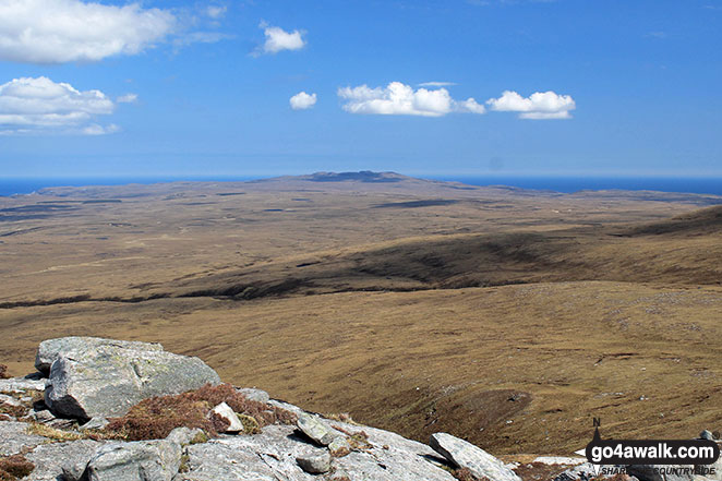
 Ben More Assynt in Assynt and The Far North
Photo: Elizabeth Maitland
Is there a Mountain, Peak, Top or Hill missing from the above google map or list?
Let us know an we will add it to our database.
To contribute to go4awalk.com or to contact us about anything at all - see Talk To Us.
For help see Help.
go4awalk.com and go4awalk.co.uk are registered trademarks of TMDH Limited.
Copyright © 2000-2025 TMDH Limited. All rights reserved.
Copyright Terms & Conditions Privacy Statement
A - Z Walks Home Log On/Accounts Photo Gallery Walk Ideas and Collections Fell Facts Hill Skills Walking Questions and Answers Your Stories News Competitions Product Reviews/Gear Tests Walking Gear Guides Peaks and Mountains Peak Bagging Find New Walking Friends Camping GPS Waypoints for Walking Contents Walk Search Talk To Us go4awalk.com Help Free Example Walks Newsletter


