Mynyddoedd Cambria (The Cambrian Mountains) - a fully detailed list of all the Mountains, Peaks, Tops and Hills (Page of 2)
The South Eastern Area of The South Eastern Area of Mynyddoedd Cambria (The Cambrian Mountains), Carmarthenshire and Powys is the area enclosed by:
- the A44 from Rhayder to the country border between Wales and England at Old Radnor to the North;
- the country border from Old Radnor to Hay-on Wye to the East; the Brecon Beacons National Park boundary from Hay-on-Wye to Llandovery to the South;
- the A489 from Llandovery to Builth Wells and then the A470 from Builth Wells to Rhayader to the West
If you include all the Mountains (Hewitts), the Deweys, the Nuttalls, the Marilyns, the Bridgets (Hills) and all the Mountains, Tops, Peaks and Hills with a Trig Point on them there are 31 tops to climb, bag & conquer and the highest point is Great Rhos at 660m (2,166ft).
To see these Mountains, Peaks, Tops and Hills displayed in different ways - see the options in the left-hand column and towards the bottom of this page.
![]() Your Personal Bagging Record for The South Eastern Area of The South Eastern Area of Mynyddoedd Cambria (The Cambrian Mountains)
Your Personal Bagging Record for The South Eastern Area of The South Eastern Area of Mynyddoedd Cambria (The Cambrian Mountains)
LOG ON and RELOAD this page to show which Mountains, Peaks, Tops and Hills you have already climbed, bagged & conquered [. . . more details]
Page 1 of 2 Go to page: 1 2 |
See this list in: Alphabetical Order‡
| Height Order
To reverse the order select the link again.
Mountain, Peak, Top or Hill:
Bagged

![]()
1. Aberedw Hill
451m (1,480ft)
Aberedw Hill is on interactive maps:
A downloadable go4awalk.com PDF Peak Bagging Map featuring Aberedw Hill will be available soon. |

![]()
2. Bache Hill
610m (2,002ft)
Bache Hill is on interactive maps:
A downloadable go4awalk.com PDF Peak Bagging Map featuring Bache Hill will be available soon. |

![]()
3. Banc y Celyn
472m (1,549ft)
Banc y Celyn is on interactive maps:
A downloadable go4awalk.com PDF Peak Bagging Map featuring Banc y Celyn will be available soon. |
![]()
4. Black Mixen
650m (2,133ft)
Black Mixen is on interactive maps:
A downloadable go4awalk.com PDF Peak Bagging Map featuring Black Mixen will be available soon. |
![]()
5. Carneddau (Radnor Forest)
445m (1,460ft)
Send it in and we'll publish it here.
Carneddau (Radnor Forest) is on interactive maps:
A downloadable go4awalk.com PDF Peak Bagging Map featuring Carneddau (Radnor Forest) will be available soon. |

![]()
6. Fron-wen
546m (1,791ft)
Fron-wen is on interactive maps:
A downloadable go4awalk.com PDF Peak Bagging Map featuring Fron-wen will be available soon. |
![]()
7. Garth (Builth Wells)
281m (922ft)
Send it in and we'll publish it here.
Garth (Builth Wells) is on interactive maps:
A downloadable go4awalk.com PDF Peak Bagging Map featuring Garth (Builth Wells) will be available soon. |
![]()
8. Gilwern Hill (Cambrian Mountains)
439m (1,440ft)
Send it in and we'll publish it here.
Gilwern Hill (Cambrian Mountains) is on interactive maps:
A downloadable go4awalk.com PDF Peak Bagging Map featuring Gilwern Hill (Cambrian Mountains) will be available soon. |
![]()
9. Glascwm Hill
522m (1,713ft)
Glascwm Hill is on interactive maps:
A downloadable go4awalk.com PDF Peak Bagging Map featuring Glascwm Hill will be available soon. |
![]()
10. Gors Lydan
528m (1,732ft)
Gors Lydan is on interactive maps:
A downloadable go4awalk.com PDF Peak Bagging Map featuring Gors Lydan will be available soon. |

![]()
11. Great Creigau
646m (2,120ft)
Great Creigau is on interactive maps:
A downloadable go4awalk.com PDF Peak Bagging Map featuring Great Creigau will be available soon. |

![]()
12. Great Rhos
660m (2,166ft)
Great Rhos is on interactive maps:
A downloadable go4awalk.com PDF Peak Bagging Map featuring Great Rhos will be available soon. |

![]()
13. Gwastedyn Hill
477m (1,565ft)
Gwastedyn Hill is on interactive maps:
A downloadable go4awalk.com PDF Peak Bagging Map featuring Gwastedyn Hill will be available soon. |

![]()
14. Gwaunceste Hill (Gwaun-Ceste Hill)
542m (1,778ft)
Send it in and we'll publish it here.
Gwaunceste Hill (Gwaun-Ceste Hill) is on interactive maps:
A downloadable go4awalk.com PDF Peak Bagging Map featuring Gwaunceste Hill (Gwaun-Ceste Hill) will be available soon. |

![]()
15. Llanfihangel Hill (Colva Hill)
532m (1,746ft)
Send it in and we'll publish it here.
Llanfihangel Hill (Colva Hill) is on interactive maps:
A downloadable go4awalk.com PDF Peak Bagging Map featuring Llanfihangel Hill (Colva Hill) will be available soon. |
![]()
16. Moelfre (Builth Wells)
442m (1,450ft)
Send it in and we'll publish it here.
Moelfre (Builth Wells) is on interactive maps:
A downloadable go4awalk.com PDF Peak Bagging Map featuring Moelfre (Builth Wells) will be available soon. |
![]()
17. Mwmffri
302m (991ft)
Mwmffri is on interactive maps:
A downloadable go4awalk.com PDF Peak Bagging Map featuring Mwmffri will be available soon. |
![]()
18. Mynydd Bwlch-y-Groes (Blaen-y-Glyn)
442m (1,450ft)
Send it in and we'll publish it here.
Mynydd Bwlch-y-Groes (Blaen-y-Glyn) is on interactive maps:
A downloadable go4awalk.com PDF Peak Bagging Map featuring Mynydd Bwlch-y-Groes (Blaen-y-Glyn) will be available soon. |
![]()
19. Mynydd Eppynt (Mynydd Epynt)
478m (1,568ft)
Send it in and we'll publish it here.
Mynydd Eppynt (Mynydd Epynt) is on interactive maps:
A downloadable go4awalk.com PDF Peak Bagging Map featuring Mynydd Eppynt (Mynydd Epynt) will be available soon. |
![]()
20. Noethgrug
412m (1,352ft)
Noethgrug is on interactive maps:
A downloadable go4awalk.com PDF Peak Bagging Map featuring Noethgrug will be available soon. |
![]()
21. Nyth-grug
538m (1,765ft)
Nyth-grug is on interactive maps:
A downloadable go4awalk.com PDF Peak Bagging Map featuring Nyth-grug will be available soon. |
![]()
22. Pool Hill
516m (1,693ft)
Pool Hill is on interactive maps:
A downloadable go4awalk.com PDF Peak Bagging Map featuring Pool Hill will be available soon. |
![]()
23. Red Hill (Rhulen)
509m (1,670ft)
Red Hill (Rhulen) is on interactive maps:
A downloadable go4awalk.com PDF Peak Bagging Map featuring Red Hill (Rhulen) will be available soon. |
![]()
24. Rhiw Gwraidd
442m (1,450ft)
Rhiw Gwraidd is on interactive maps:
A downloadable go4awalk.com PDF Peak Bagging Map featuring Rhiw Gwraidd will be available soon. |
![]()
25. Rhiw Gwraidd (East Top)
442m (1,450ft)
Send it in and we'll publish it here.
Rhiw Gwraidd (East Top) is on interactive maps:
A downloadable go4awalk.com PDF Peak Bagging Map featuring Rhiw Gwraidd (East Top) will be available soon. |
![]()
26. Stanky Hill
506m (1,660ft)
Stanky Hill is on interactive maps:
A downloadable go4awalk.com PDF Peak Bagging Map featuring Stanky Hill will be available soon. |
![]()
27. The Begwns
415m (1,362ft)
The Begwns is on interactive maps:
A downloadable go4awalk.com PDF Peak Bagging Map featuring The Begwns will be available soon. |
![]()
28. Twyn Disgwylfa
417m (1,368ft)
Twyn Disgwylfa is on interactive maps:
A downloadable go4awalk.com PDF Peak Bagging Map featuring Twyn Disgwylfa will be available soon. |
![]()
29. Warren Hill (Dildre Bank)
507m (1,663ft)
Send it in and we'll publish it here.
Warren Hill (Dildre Bank) is on interactive maps:
A downloadable go4awalk.com PDF Peak Bagging Map featuring Warren Hill (Dildre Bank) will be available soon. |
![]()
30. Whimble
599m (1,965ft)
Whimble is on interactive maps:
A downloadable go4awalk.com PDF Peak Bagging Map featuring Whimble will be available soon. |
Page 1 of 2 Go to page: 1 2 |
View these 31 Mountains, Peaks, Tops and Hills:
- On an Interactive Google Map (loads faster)
- On an Interactive Google Map with a list of tops below it.
(makes it easier to locate a particular top) - On a Detailed List in:
Alphabetical Order | Height Order - On one page with 'yet-to-be-bagged' listed 1st & then 'already-bagged' tops listed 2nd in:
Alphabetical Order | Height Order - On one page with 'already-bagged' tops listed 1st & then 'yet-to-be-bagged' tops listed 2nd in:
Alphabetical Order | Height Order
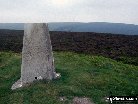
 The summit of Great Rhos in The South Eastern Area of Mynyddoedd Cambria (The Cambrian Mountains)
Photo: Bryn Owens
Is there a Mountain, Peak, Top or Hill missing from the above google map or list?
Let us know an we will add it to our database.
To contribute to go4awalk.com or to contact us about anything at all - see Talk To Us.
For help see Help.
go4awalk.com and go4awalk.co.uk are registered trademarks of TMDH Limited.
Copyright © 2000-2026 TMDH Limited. All rights reserved.
Copyright Terms & Conditions Privacy Statement
A - Z Walks Home Log On/Accounts Photo Gallery Walk Ideas and Collections Fell Facts Hill Skills Walking Questions and Answers Your Stories News Competitions Product Reviews/Gear Tests Walking Gear Guides Peaks and Mountains Peak Bagging Find New Walking Friends Camping GPS Waypoints for Walking Contents Walk Search Talk To Us go4awalk.com Help Free Example Walks Newsletter


