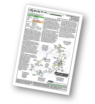
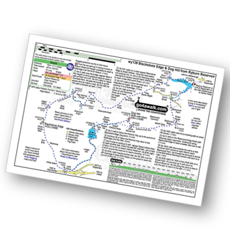
The 30 nearest, easy-to-follow, circular walks, routes & maps to UK Postcode HD8
The thirty nearest, easy-to-follow, circular walks, routes & maps to UK Postcode HD8 in Walk Grade Order
The UK cities, towns and villages in West Yorkshire, England that have HD8 in their UK Postcode include:
• Clayton West • Cowmes • Denby Dale • Emley • Highburton • Kirkburton • Lane Head • Lepton • Shelley • Shepley • Skelmanthorpe • Upper Denby •
Tap/mouse over a coloured circle (1-3 easy walks, 4-6 moderate walks, 7-9 hard walks) and click to select.
Scroll down the list of walks below & click on each walk title (in blue) to locate it on the map above.
   |
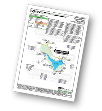
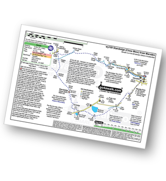
Vital Statistics:
| Length: | 6 miles (9.5 km) |
| Ascent: | 1,152ft (351m) |
| Time: | 3.25hrs |
| Grade: |  |
Route Summary:
Holmfirth - Nora Batty's House and Sid's Cafe (Last of The Summer Wine) - Malkin Farm - River Holme - Hinchliffe Mill - Hogley Green - Hogley Farm - Upperthong - Netherthong - Holmfirth
|
Vital Statistics:
| Length: | 11.5 miles (18.5 km) |
| Ascent: | 1,674ft (510m) |
| Time: | 6 hrs |
| Grade: |  |
Route Summary:
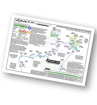
The Flouch Car Park - Crookland Wood - Swinden Lane - Fox Clough - Langsett Moors - Barmings - Hordron Road - Long Moor Clough - Hordron Clough - The Porter or Little Don River - Laund Clough - Harden Moor - Howden Edge - Hoar Stones - Horse Stone (Horse Stone Naze) - Stainery Clough Head - Howden Moors - Crow Stones - Crow Stones Edge - Outer Edge - Cut Gate End - Cut Gate Path - Mickleden Edge - Delf Edge - Langsett Reservoir - The Porter or Little Don River - The Flouch.
|
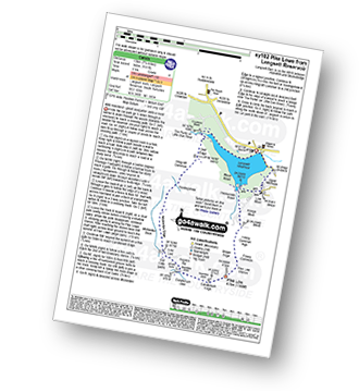
Vital Statistics:
| Length: | 12 miles (19 km) |
| Ascent: | 1,365ft (416m) |
| Time: | 5.75hrs |
| Grade: | |
Route Summary:
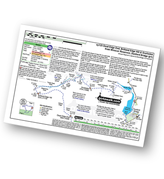
Winscar Reservoir - Dunford Bridge - The Barnsley Boundary Walk - Little Moor - The Trans Pennine Trail - The Longdendale Trail - Windle Edge - Bagshaw Ridge - Gallows Moss - Salter's Brook Moss - Long Side - Hawthorn Clough - Woodhead Railway Tunnel Air Shaft - Upper Head Dike - Dead Edge End - Upper Dead Edge - Grains Moss - Withins Edge - Britland Edge Hill - Bleakmires Moss - Twizle Head Moss - Lad Clough Knoll - Ramsden Clough - Snailsden - Upper Snailsden Moss - Harden Clugh - Harden Reservoir - Winscar Reservoir - Dunford Bridge.
|
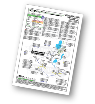
Vital Statistics:
| Length: | 5.5 miles (8.5 km) |
| Ascent: | 728ft (222m) |
| Time: | 2.75hrs |
| Grade: |  |
Route Summary:
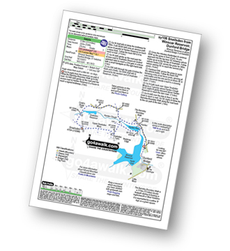
Winscar Reservoir - Dunford Bridge - Harden Reservoir - Harden Clough - Cook's Study Hill - Snailsden Reservoir - Snailsden - Upper Snailsden Moss - Harden Clugh - Harden Reservoir - Winscar Reservoir - Dunford Bridge.
|
Vital Statistics:
| Length: | 3.75 miles (6.5 km) |
| Ascent: | 673ft (205m) |
| Time: | 2.25hrs |
| Grade: | |
Route Summary:
Langsett Barn - Langsett - Langsett Reservoir Dam - Upper Midhope - Thickwoods - Thickwoods Brook - North America Farm - Delf Edge - Langsett Reservoir - The Porter or Little Don River - Crookland Wood - Langsett Reservoir - Langsett Barn
|
Vital Statistics:
| Length: | 7.5 miles (12 km) |
| Ascent: | 1,118ft (360m) |
| Time: | 4 hrs |
| Grade: | |
Route Summary:
Langsett Barn - Langsett - Langsett Reservoir - Langsett Reservoir Dam - Upper Midhope - Thickwoods - Thickwoods Brook - Fenny Common Ings - Fenny Common - Pike Lowe Stones - Pike Lowe - Candlerush Edge - Sugden Top - Lost Lad (Langsett) - Mickleden Edge (Langsett) - Haslingshaw Hingcliff Common - Delf Edge - Langsett Reservoir - The Porter or Little Don River - Crookland Wood - Langsett Reservoir - Langsett Barn
|
Vital Statistics:
| Length: | 5.25 miles (8.5 km) |
| Ascent: | 817ft (249m) |
| Time: | 2.75hrs |
| Grade: | |
Route Summary:
Winscar Reservoir - Dunford Bridge - The Barnsley Boundary Walk - Little Moor - The Trans Pennine Trail - The Longdendale Trail - Windle Edge - Upper Windleden Reservoir - Fiddlers Green - South Nab - Lady Cross - Salter's Brook Moss - Gallows Moss - Carr Top - Woodhead Railway Tunnel Air Shaft - Upper Grip Hill - Lower Grip Hill - Winscar Reservoir - Dunford Bridge.
|
Vital Statistics:
| Length: | 7.25 miles (11.5 km) |
| Ascent: | 896ft (273m) |
| Time: | 3.75hrs |
| Grade: |  |
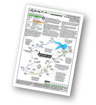
Route Summary:
Winscar Reservoir - Dunford Bridge - The Barnsley Boundary Walk - Little Moor - The Trans Pennine Trail - The Longdendale Trail - Windle Edge - Bagshaw Ridge - Gallows Moss - Salter's Brook Moss - Long Side (Woodhead) - Hawthorn Clough - Woodhead Railway Tunnel Air Shaft - Upper Head Dike - Dead Edge End - Upper Dead Edge - Grains Moss - Little Grains Clough - Winscar Reservoir - Dunford Bridge.
|
Vital Statistics:
| Length: | 8.75 miles (14 km) |
| Ascent: | 1,316ft (401m) |
| Time: | 4½ hrs |
| Grade: | |
Route Summary:
Meltham - Royd Edge - Meltham Moor - Cock Crowing Stone - West Nab - Hey Sike Clough - Horseley Head Moss - Wessenden - Binn Moor - Deer Hill Reservoir - Meltham
|
Vital Statistics:
| Length: | 9.75 miles (15.5 km) |
| Ascent: | 1,902ft (580m) |
| Time: | 5½ hrs |
| Grade: | |
Route Summary:
Wessenden Head - The Pennine Way - Wessenden Reservoir - Wessenden Lodge - Blakely Clough - Black Moss Reservoir - Black Hill (Soldier's Lump) - Wessenden Head
|
Vital Statistics:
| Length: | 10.5 miles (17 km) |
| Ascent: | 1,975ft (602m) |
| Time: | 5.75hrs |
| Grade: | |
Route Summary:
Woodhead Tunnel - Middle Black Clough - Bleaklow Stones (Bleaklow Hill) - Bleaklow Head (Bleaklow Hill) - The Wain Stones (or Kissing Stones) - The Pennine Way - Clough Edge - The Longdendale Trail - Crowden - Woodhead Reservoir - Woodhead Tunnel
|
Vital Statistics:
| Length: | 13.25 miles (21 km) |
| Ascent: | 2,081ft (634m) |
| Time: | 7 hrs |
| Grade: |  |
Route Summary:
Woodhead Tunnel - Far Black Clough - Swains Head - Swains Greave - Barrow Stones - Grinah Stones - Bleaklow Stones (Bleaklow Hill) - Bleaklow Head (Bleaklow Hill) - The Wain Stones (or Kissing Stones) - The Pennine Way - Joseph Patch - John Track Well - Torside Clough - Peaknaze Moor - Reaps Farm - The Longdendale Trail - Torside Reservoir - Woodhead Reservoir - Woodhead Tunnel
|
Vital Statistics:
| Length: | 8.5 miles (13.5 km) |
| Ascent: | 1,319ft (405m) |
| Time: | 4½ hrs |
| Grade: | |
Route Summary:
Marsden - Tunnel End - Hey Green - Close Gate Bridge - Stack End - Willkay Clough - Green Laitch - Wilmer Green Clough - Broad Wham - Haigh Gutter - The Pennine Way - Oldgate Moss - Haigh Gutter Moss - Blea Green - Northern Rotcher - Dinner Stone - Standedge (Close Moor) - Millstone Edge - Standedge - Brun Moor - Brun Clough Reservoir - Redbrook Rreservoir - The Standedge Trail - Carr Clough - Marsden
|
Vital Statistics:
| Length: | 5.25 miles (8.5 km) |
| Ascent: | 823ft (251m) |
| Time: | 2.75hrs |
| Grade: | |
Route Summary:
Crowden - The Pennine Way - Torside Reservoir - Rhodeswood Reservoir - The Longdendale Trail - The Pennine Way - Torside Reservoir - Crowden
|
Vital Statistics:
| Length: | 7.25 miles (11.5 km) |
| Ascent: | 1,515ft (562m) |
| Time: | 4.25hrs |
| Grade: | |
Route Summary:
Crowden - The Pennine Way - Torside Reservoir - Rhodeswood Reservoir - Higher Deepclough - Devil's Elbow - Ogden Clough - Nell's Pike - Bramah Edge - Peaknaze Moor - The Pennine Way - Torside Reservoir - Crowden
|
Vital Statistics:
| Length: | 8.5 miles (13.5 km) |
| Ascent: | 2,289ft (698m) |
| Time: | 5½ hrs |
| Grade: | |
Route Summary:
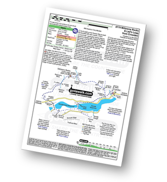
Crowden - The Pennine Way - Highstone Rocks - Lad's Leap - Millstone Rocks (Lad's Leap) - Rhodeswood Reservoir - Higher Deepclough - Devil's Elbow - Ogden Clough - Nell's Pike - Bramah Edge - Peaknaze Moor - The Pennine Way - Torside Reservoir - Crowden
|
Vital Statistics:
| Length: | 6.25 miles (10 km) |
| Ascent: | 1,610ft (491m) |
| Time: | 4 hrs |
| Grade: | |
Route Summary:
Crowden - The Pennine Way - Highstone Rocks - Lad's Leap - Millstone Rocks (Lad's Leap) - Rhodeswood Reservoir - The Longdendale Trail - The Pennine Way - Torside Reservoir - Crowden
|
Vital Statistics:
| Length: | 9 miles (14.5 km) |
| Ascent: | 1,746ft (532m) |
| Time: | 5 hrs |
| Grade: | |
Route Summary:
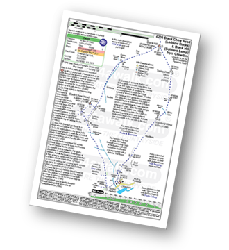
Crowden - Crowden Brook - The Pennine Way - Highstone Rocks - Span Gutter - Rakes Rocks - Oakenclough Brook - Laddow Moss - Black Chew Head (Laddow Rocks) - Near Broadslate - Sliddens - Dun Hill - Black Hill (Soldier's Lump) - Tooleyshaw Moss - Tooleyshaw Moor - White Low - Westend Moss - Hey Moss - Hey Edge - Crowden
|
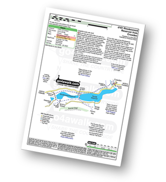
Vital Statistics:
| Length: | 3.75 miles (6 km) |
| Ascent: | 562ft (171m) |
| Time: | 2 hrs |
| Grade: |  |
Route Summary:
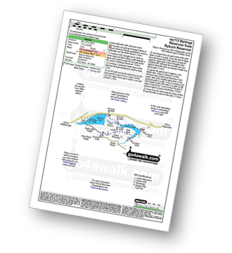
Ryburn Reservoir - River Ryburn - Baitings Reservoir - Back O'the Height - Hutch Brook - Ryburn Reservoir
|
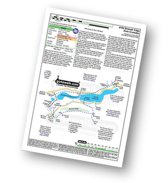
Vital Statistics:
| Length: | 7.5 miles (12 km) |
| Ascent: | 1,241ft (378m) |
| Time: | 4 hrs |
| Grade: | |
Route Summary:
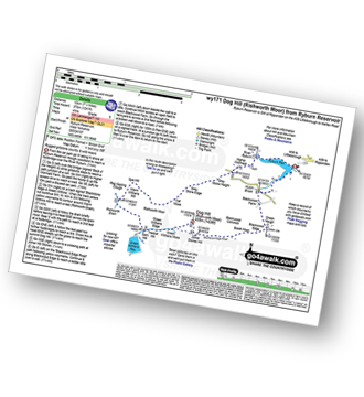
Ryburn Reservoir - River Ryburn - Higher Wormaid - Grey Stone Height - Cat Moss - Rishworth Moor - Warm Withens Hill - Rishworth Drain - Sam Hill - Green Withens Reservoir - Green Withens Moss - Dog Hill (Rishworth Moor) - Blackwood Edge - Blackwood Farm - Hutch Brook - Ryburn Reservoir
|
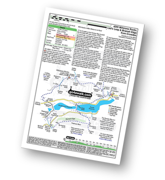
Vital Statistics:
| Length: | 11.25 miles (18 km) |
| Ascent: | 1,631ft (497m) |
| Time: | 5.75hrs |
| Grade: | |
Route Summary:
Ryburn Reservoir - River Ryburn - Higher Wormaid - Grey Stone Height - Cat Moss - Rishworth Moor - Warm Withens Hill - Rishworth Drain - Rag Sapling Clough - Blackstone Edge Moor - Old Packhorse Road - Dick Slack - The Aiggin Stone - The Pennine Way - Blackstone Edge - Robin Hoods Bed - Sun End - Redmires - White Isles - Lads Grave - M62 - Green Withens Reservoir - Green Withens Edge - Dog Hill (Rishworth Moor) - Blackwood Edge - Blackwood Farm - Hutch Brook - Ryburn Reservoir
|
Vital Statistics:
| Length: | 5 miles (8 km) |
| Ascent: | 607ft (246m) |
| Time: | 2½ hrs |
| Grade: | |
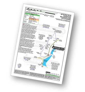
Route Summary:
Binn Green Car Park - Greenfield - The Oldham Way - Pots and Pans War Memorial - Dick Hill - Shaw Rocks - Slades Rocks - Saddleworth Moor - Saddleworth (Broadstone Hill) - Binn Green Car Park - Greenfield.
|
Vital Statistics:
| Length: | 7 miles (11 km) |
| Ascent: | 1,615ft (492m) |
| Time: | 4.25hrs |
| Grade: | |
Route Summary:
Dove Stone Reservoir - Greenfield - The Oldham Way - Chew Brook - Chew Reservoir - Stable Stones Brow (Hoarstone Edge) - Alphin Pike - Dove Stone Reservoir
|
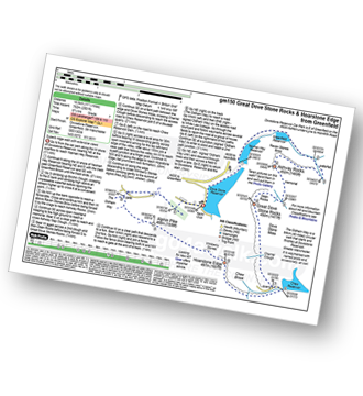
Vital Statistics:
| Length: | 8.5 miles (13.5 km) |
| Ascent: | 1,848ft (563m) |
| Time: | 5 hrs |
| Grade: | |
Route Summary:
Dove Stone Reservoir - Greenfield - The Oldham Way - Yeoman Hey Reservoir - Greenfield Reservoir - Birchin Clough - Raven Stones Brow - Ashway Rocks - Ashway Gap - Dean Rocks - Great Dove Stone Rocks - Dove Stone Moss - Chew Reservoir - Chew Brook - Dove Stone Reservoir
|
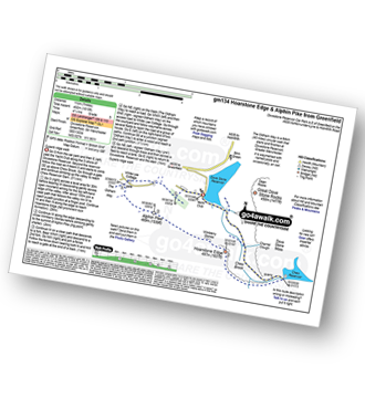
Vital Statistics:
| Length: | 6.25 miles (10 km) |
| Ascent: | 1,441ft (439m) |
| Time: | 3.75hrs |
| Grade: | |
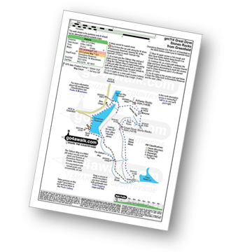
Route Summary:
Dove Stone Reservoir - Greenfield - The Oldham Way - Yeoman Hey Reservoir - Ashway Rocks - Ashway Gap - Dean Rocks - Great Dove Stone Rocks - Dove Stone Moss - Chew Reservoir - Chew Brook - Dove Stone Reservoir
|
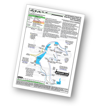
Vital Statistics:
| Length: | 4.5 miles (7 km) |
| Ascent: | 729ft (222m) |
| Time: | 2½ hrs |
| Grade: | |
Route Summary:
Dove Stone Reservoir - Greenfield - The Oldham Way - Yeoman Hey Reservoir - Dove Stone Reservoir
|
Vital Statistics:
| Length: | 11.5 miles (18.5 km) |
| Ascent: | 2,501ft (762m) |
| Time: | 6.75hrs |
| Grade: | |
Route Summary:
Dove Stone Reservoir - Greenfield - The Oldham Way - Yeoman Hey Reservoir - Greenfield Reservoir - Birchin Clough - Raven Stones Brow - Ashway Rocks - Dean Rocks - Great Dove Stone Rocks - Chew Reservoir - Stable Stones Brow (Hoarstone Edge) - Alphin Pike - Dove Stone Reservoir
|
Vital Statistics:
| Length: | 10 miles (16 km) |
| Ascent: | 2,368ft (722m) |
| Time: | 6 hrs |
| Grade: | |
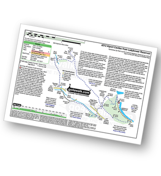
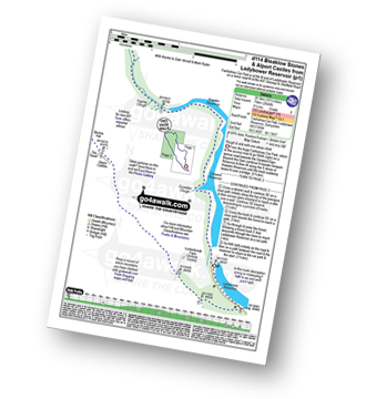
Route Summary:
Ladybower Reservoir - Fairholmes Car Park - Lockerbrook Farm - Lockerbrook Heights - Rowlee Pasture - Alport Castles - River Alport - Alport Dale - Alport Farm - Hayridge Farm - Upper Ashop - Blackley Clough - Hagg Farm - Hagg Side - Fairholmes Car Park - Ladybower Reservoir
|
Vital Statistics:
| Length: | 12.75 miles (20.5 km) |
| Ascent: | 2,094ft (638m) |
| Time: | 6.75hrs |
| Grade: | |
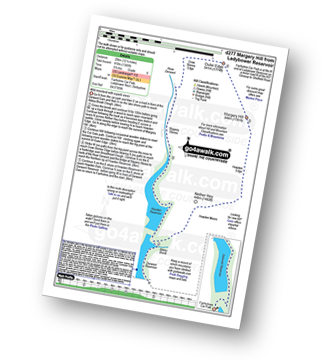
Route Summary:
Ladybower Reservoir - Fairholmes Car Park - Derwent Reservoir - Abbey Bank - Abbey Brook - Hey Bank (Nether Hey) - Howden Moors - Nether Hey (Howden Edge) - Row Top - Featherbed Moss (Howden Edge) - High Stones (Howden Moor) - Willfrey Edge - High Peak - Margery Stones - Margery Hill - Outer Edge - Crow Stones - Crow Stones Edge - Airspeed Consul TF-RPM Plane Wreckage - Broadhead Clough - Cranberry Bed - Swine Side - Cranberry Clough - Cold Side Oaks - Slippery Stones - Packhorse Bridge (River Derwent) - Howden Reservoir - Cold Side (Howden Reservoir) - Derwent Reservoir - Fairholmes Car Park - Ladybower Reservoir
|
Vital Statistics:
| Length: | 16.5 miles (26.5 km) |
| Ascent: | 2,604ft (794m) |
| Time: | 8½ hrs |
| Grade: |  |
Route Summary:
Ladybower Reservoir - Fairholmes Car Park - Derwent Reservoir - Howden Reservoir - Fagney Clough - Ridgewalk Moor - Barrow Stones - Bleaklow Stones (Bleaklow Hill) - Alport Moor - West End Moor - Birchin Hat - Alport Castles - Rowlee Pasture - Lockerbrook Heights - Lockerbrook Farm - Fairholmes Car Park - Ladybower Reservoir


