Four easy to follow pub walks from The Craven Arms Hotel, Craven Arms, Shropshire, England
To reach The Craven Arms Hotel, Craven Arms, in-car SatNav users should select the Latitude/Longitude (Lat Lon) screen and enter:
Lat = N52.43966 and Lon = W 2.83606
Get directions to The Craven Arms Hotel in Craven Arms
Scroll down the list of walks below & click on each walk title (in blue) to locate it on the map above.
   |
Vital Statistics:
| Length: | 6.5 miles (10.5 km) |
| Ascent: | 853ft (260m) |
| Time: | 3.25hrs |
| Grade: |  |
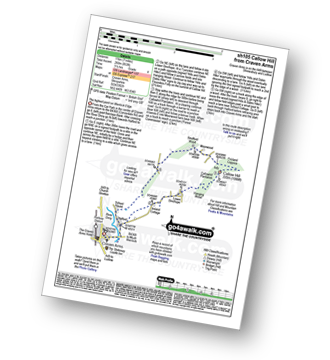
Route Summary:
Craven Arms - River Onny - Halford - Ireland Cottage - Hills and Dales Hike - Lower Dinchope - Hanging Wood - Callowhill Plantation - Wenlock Edge - Callow Hill (Little Stretton) - Flounders Folly - Frizland Coppice - Moorwood Farm - Strefford Wood - Berrymill Wood - Halford - Craven Arms
|
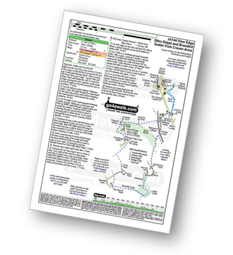
Vital Statistics:
| Length: | 7 miles (11 km) |
| Ascent: | 880ft (268m) |
| Time: | 3½ hrs |
| Grade: | |

Route Summary:
Craven Arms - River Onny - Hills and Dales Hike - Stokesay Castle - Clapping Wicket - View Edge (Weo Edge) - Aldon - Stokesay Castle - River Onny - Craven Arms
|
Vital Statistics:
| Length: | 9 miles (14.5 km) |
| Ascent: | 1,004ft (306m) |
| Time: | 4½ hrs |
| Grade: |  |
Route Summary:
Craven Arms - River Onny - Hills and Dales Hike - Stokesay Castle - Clapping Wicket - View Edge (Weo Edge) - Gorst Barn - Brandhill Gutter - Aldon Gutter - Aldon - Stokesay Castle - River Onny - Craven Arms
|
Vital Statistics:
| Length: | 10.25 miles (16.5 km) |
| Ascent: | 1,526ft (465m) |
| Time: | 5.25hrs |
| Grade: |  |
Route Summary:
Craven Arms - Ireland Cottage - Hills and Dales Hike - Lower Dinchope - Hanging Wood - Wenlock Edge - Callow Hill (Little Stretton) - Flounders Folly - Frizland Coppice - Westhope - Wenlock Edge - Alcaton Common - Strefford Wood - Halford - Craven Arms


